Cooper Canyon Falls, July 30, 2017: Buckhorn Campground, Pleasant View Ridge Wilderness, Burkhart Trail to Cooper Canyon Falls, Little Rock Creek (776 ft. +/-) 3.7 miles RT

Cooper Canyon Falls, July 30, 2017:  Buckhorn Campground, Pleasant View Ridge Wilderness, Burkhart Trail to Cooper Canyon Falls, Little Rock Creek (776 ft. +/-) 3.7 miles RT

This is a very pretty, very green trail that starts at Buckhorn Campground and leads you into the Pleasant View Ridge Wilderness via Burkhart trail down to Cooper Canyon Falls. This is an upside down trail, so if you do it as an out and back you'll gain your elevation on the way back going all uphill. The falls were just a trickle, but it was a beautiful hike and fun to explore the creek at the bottom of the canyon. 

We started our hike around 07:25 AM from Buckhorn Campground on the Burkhart Trail leading into Pleasant View Ridge Wilderness, 26,752 acres of protected land.  You do not need a permit to enter this wilderness.  The moment you step onto the trail, you are engrossed in a forest of lush green.  Oak, Douglas Fir, Jeffrey Pine and Incense Cedar offer a canopy of shade along almost the entire journey.  As you walk, you can see and hear Little Rock Creek far below.  It’s very peaceful with only the sounds of flowing water and morning songbirds.  Aside from the campground which was very full, the trail itself was quiet and we had it mostly to ourselves the entire hike.  The trail makes a steady descent downward into the canyon.  It’s an easy grade and not too steep, although as you get closer to the falls, it can get a little rocky with some loose gravel.  It's nothing too difficult, just watch your step.  Along the way we crossed over two creek beds which were nice for photography.  We took our time to explore the area and did a little boulder hopping along the creek.  

It seemed we’d traveled a bit further then we should have to get to the falls, and we still hadn’t seen them.  I got out my map to take a look to see where we were.  As suspected, we had actually passed the area where they were supposed to be.  At this point we headed back the way we came, and I found the use trail which is a short, but steep scramble to get to the bottom of the canyon where the falls would normally be had it not been summer.  At this time of year, however, they were just a trickle of running water on mossy rock which is why they were so easily missed.

Although there wasn’t a rushing waterfall to see, we were not at all disappointed.  This hike was beautiful.  Satisfied that we’d reached our destination, we now continued our ascent all uphill now back to the trailhead at Buckhorn Campground.  We took our time to enjoy the scenery and peaceful splendor of the wilderness.  

Read More

Under the Milky Way... Joshua Tree National Park, July 22 & 23, 2017

Under the Milky Way... Joshua Tree National Park, July 22 & 23, 2017

I love spending time in the desert.  Even in the middle of July.  If you take it easy, bring a lot of water with you and use common sense, you can still enjoy the park despite temperatures that are usually in the 100s.  This trip was all about shooting the night sky.  I have been wanting to get a halfway decent photo of the Milky Way for as long as I can remember.  It took some researching, but I was ready.  I even went so far as to purchase a good tripod and with my shooting style, I do NOT like using a tripod.  For night sky though, it is a must.  

We arrived at Campbell House, my absolute favorite place to stay when we’re in Twentynine Palms, a little after noon.  We checked in, packed plenty of water and headed into the park.  The temperature fluctuated between 90 and 108 depending on where we were.  I had decided to take advantage of the park being less crowded and see some of the more popular sites.  The first stop was Hidden Valley nature trail, an easy one mile loop.  There’s a passage through the rocks that open to a “hidden” valley enclosed by these incredible rock formations. It’s said that this area was once used by cattle thieves to hide their stolen cattle. As you walk along the trail, you’ll also see some beautiful pinyon pines.

After Hidden Valley, we drove to Keys View to take in the panoramic views of the Coachella Valley, Salton Sea and the San Andreas fault. At an elevation of 5,240 ft., it was about 10 degrees cooler (90) and there was a nice breeze. There were also a lot of bees flying around looking for moisture under the cars from the a/c. 

After Keys View, we stopped at Cap Rock, notable for being the place where the stolen corpse of singer, Gram Parsons was set on fire in 1973.  I took some photos there and we headed back to get cleaned up for dinner.

When in Twentynine Palms, we always have dinner at the Twentynine Palms Inn.  My husband always orders the prime rib, and I always get the lobster tail.  It never disappoints!

It was getting close to sunset so after dinner we headed back into the park.  I decided to go back to Cap Rock to settle in and get ready for the show and an evening of stargazing and Milky Way photography.  As the sun went down, it provided me with a surreal kaleidoscope of color; magnificent golds, yellow, orange, magenta and hypnotic blue.  Then, as the light faded away, the first stars began to appear.  Magic!  It was just after 9:30 when the Milky Way became clearly visible.  I was super stoked to be able to get some images.  I had timed this trip so we’d be there on a dark moon and we had a perfectly clear sky.  Mission accomplished!

I slept so good Saturday night.  The Campbell House is so cozy it’s like being in your own home.  I actually sleep better there than I do at my own house!  It’s so peaceful and quiet.

The next morning I decided to sleep in.  That would be 6 am for me.  I usually get up and drive into the park to see the sunrise, but the cottage was just a little too comfortable and I woke up just as the sun was starting to come up.

Around 7:30 we went to the great room to enjoy coffee and breakfast.  They always have something delicious and this time it was Tres Leche French Toast with Dulce de Leche on top!  Wow!  Supurb!  

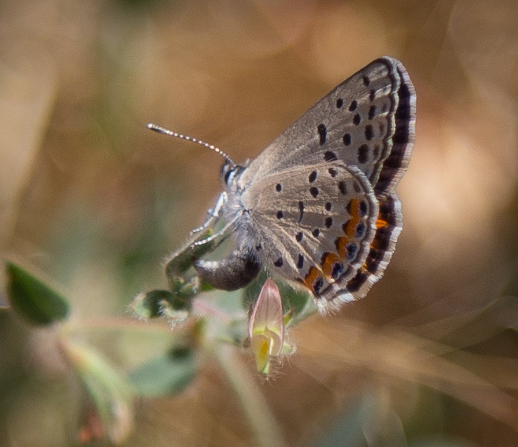
After a very enjoyable breakfast, we stopped by the Oasis of Mara.  All the times I’ve been to Joshua Tree and I’d never been there.  I’m glad I did because I was able to photography my first Western Pygmy Blue.  According to my field guide, it is the smallest butterfly in North America and also one of the smallest in the world at 3/8 - 3/4 inch!  

This was a really wonderful trip.  I came home with exactly what I wanted, a beautiful image of our fascinating Milky Way galaxy and an extra bonus of some new butterflies to add to my photographic collection!
 

Read More

Hiking Mt. Baden Powell, July 16, 2017 9,399 ft (2,800 ft +/-) 8 Miles RT

Hiking Mt. Baden Powell, July 16, 2017 9,399 ft (2,800 ft +/-) 8 Miles RT

I think when you grow up in Pennsylvania it’s in your blood to hike.  I can remember most of what I did when I lived there besides riding my horses was hiking the local trails and spending time in the forest.  In my 20s I drove to Virginia and hiked on the Appalachian trail along the Blue Ridge mountains in Shenandoah National Park.  It was beautiful.  This weekend my husband and I drove back up to Wrightwood to hike Mount Baden-Powell, a peak in the San Gabriel Mountains named for the founder of the World Scouting Movement, Robert Baden-Powell.  It’s also one of the highest peaks in Angeles National Forest standing at 9,399 ft.  Mount San Antonio aka Old Baldy or Mt. Baldy being the highest at 10,064 ft.  The trail begins at the Vincent Gap parking lot and follows along a section of the Pacific Crest Trail for a total of 8 miles out and back.  The only wrench in our plan was that Highway 2 has been closed since June because of a sinkhole, so we had to park at Grassy Hollow and walk almost 3 miles down the road just to get to the trailhead.  The Mt Baden Powell trail has an elevation gain of 2,800 ft. and a series of 41 switchbacks which begin to climb as soon as you start the hike.  But once you reach the top the views are sublime.  Another reward of this climb is once you’re at 9,000 ft. there’s a grove of ancient trees called limber pines, some of which are 1,000+ years old clinging to the slope.  It’s an amazing spectacle and well worth the work you have to do to get there.  If you click below on “read more” you can see some of the photos I took along the trail.

Read More

PCT: Inspiration Point from Lightning Ridge, Grassy Hollow to Jackson Flat Campground + Vincent Gap, Wrightwood, CA, (500 ft +/-), 6+ miles RT, July 9, 2017

PCT: Inspiration Point from Lightning Ridge, Grassy Hollow to Jackson Flat Campground + Vincent Gap, Wrightwood, CA, (500 ft +/-), 6+ miles RT, July 9, 2017

We started our hike today 2 miles west of Big Pines at Inspiration Point.  This hike can be made shorter by parking at the Grassy Hollow Visitors’ center, but we wanted the extra mileage so we parked at Inspiration Point and picked up the PCT trailhead located just behind the restrooms and up to the left.  Our destination was Jackson Flat Campground with an elevation gain of 500 (+/-) ft.  The walk along the PCT from Lightning Ridge immediately offered stunning views of Mount Baldy and Mount Baden Powell.  You can also see the Mojave on a clear day.  When you reach Grassy Hollow you can take a photo of the sign for the Pacific Crest Trail that shows arrows pointing to Mexico 373 miles south and to Canada 2,277 miles north.  There are switchbacks and and lot of up and downs so it’s not a steady climb the entire way.  I found this trail to be moderate.  Definitely not difficult and you also get a nice trek through the forest in the shade for part of it.  We reached the Jackson Flat Campground fairly quickly which is just up the hill and to the left of the first sign pointing to Jackson Lake.  We decided to continue along the PCT for another few miles almost to Vincent Gap.  You can also add another 2+ miles to this hike if you veer off the PCT and take the trail by the next sign pointing to Jackson Lake at the switchback.  We plan to do that next time.  On our way back we stopped at the Jackson Flat Campground to sit for a moment and enjoy the peace and quiet before continuing on.  When we started our hike in the morning it was cool and cloudy.  But by the time we started walking back, the sun was coming out and I started to see a lot of butterflies.  At the campground a pale swallowtail landed right in front of me on a pine tree. It held still for a while so I was excited to be able to get some nice shots.  There were many swallowtails in this area along the trail.  Lots of butterfly plants too including California Buckwheat and other wildflowers.  I also saw a good number of Painted Ladies flying up and down the slope just before reaching Grassy Hollow Visitors’ Center.  I’d say our hike today was about 6+ miles give or take.  I saw many butterflies on the way back between the Jackson Flat Campground back to Inspiration Point.  Definitely some good butterfly habitat in this area and a very pleasant hike.

Here is a list of some of my sightings:  

Gray Hairstreak
Hedgerow Hairstreak - still need to ID
Painted Lady - Was not able to get a clear shot but pretty sure on the ID. 
Marine Blue
Acmon or Lupine Blue - Still need to ID
Pale Swallowtail

Read More

Angeles National Forest, Grizzly Flat, July 3, 2017

Angeles National Forest, Grizzly Flat, July 3, 2017

Today was an exciting day on the Grizzly Flat trail.  I photographed my first Metalmark; Mormon Metalmark, Apodemia mormo!  

Here’s the list of what I saw today along with some photos.

Checkered White, Pontia protodice, Male
Pale Swallowtail, Papilio eurymedon
Gray Hairstreak, Strymon melinus pudica, female
Duskywing - I think this is Funereal.  I always have a hard time distinguishing the Funeral from the Mournful.
Hairstreak - Only one shot and too far away.  I think maybe a Hedgerow.
Bernardino Blue, Euphilotes bernardino - Saw lots of these.
 

Read More

Big Pines to Blue Ridge, Wrightwood, CA, (1,100 ft +/-), 4 miles RT, July 2, 2017

Big Pines to Blue Ridge, Wrightwood, CA, (1,100 ft +/-), 4 miles RT, July 2, 2017

Blue Ridge Trail is a 4 mile, moderate out and back trail that lies on a high divide of the San Gabriel Mountains near the town of Wrightwood.  The trail is mostly shaded and winds through a dense coniferous forest of pines, firs and oak.  This trail gives you a really great perspective of the back country of the San Gabriel Mountains.  It's a really enjoyable hike.
 
The trailhead is actually located across the street from the Big Pines Ranger Station.  Look for the sign near the restrooms.
 
Once you cross the wooden bridge, the trail begins to rise on a moderate grade slowly switching back up the mountain.  At about the one mile mark, you’ll pass a wooden bench.  This is the half-way marker to Blue Ridge.  At this point, you’ll still have more than half of the elevation gain to go.  The trail continues to climb steadily and you’ll continue to negotiate a few more switchbacks before it levels out at the junction of Blue Ridge and the Pacific Crest Trail (PCT) at the Blue Ridge Campground.  You'll also see the Mountain High Ski Resort.
 
 
The elevation averages about 7,500 feet and once you reach the campground, you’ll get some really pretty views.  From there you can either continue on to the PCT or you can return back the way you came.  On this day we decided to return and stop for lunch at the Grizzly Cafe in Wrightwood, which I highly recommend.
 
This is a really beautiful trail and I was happy to get some photos of butterflies (California Sister and Swallowtails) that were flying along the way.  

Read More

Angeles National Forest, Grizzly Flat, June 25, 2017

Angeles National Forest, Grizzly Flat, June 25, 2017

This weekend my husband and I were supposed to be in Joshua Tree, but with the soaring temperatures, we opted to remain local.  This morning we took a very short hike up Grizzly Flat Trailhead.  It was 92 degrees by 9 am, but we managed to get in a quick trek up the slope and I snapped just a few photos along the way.  There were swallowtails circling down and back up the summit, but they were too far away to get an image.  I did manage to catch a Bernardino Blue, as there were many on the California Buckwheat and also what I believe is a female Lupine Blue who appeared to be ovipositing.

Read More

A Butterfly Habitat in Angeles National Forest, Hiking Grizzly Flat, June 18, 2017

A Butterfly Habitat in Angeles National Forest, Hiking Grizzly Flat, June 18, 2017

This was an exciting weekend for me.  I experienced for the first time the natural butterfly habit that exists right here in Angeles National Forest.  It was incredible if not a little overwhelming.  Around 8 am we arrived at the trailhead and began our hike.  The weather was already heating up due to the current heatwave, and as we began our ascent up the slope we started to see all the activity.  Along the trail was an abundance of California Buckwheat which is both a host and nectar plant for many different species.  It was covered in different butterflies; Bernardino Blues, Hairstreaks and Chalcedon Checkerspot to name a few.  It was breathtaking seeing so many different butterflies all together in their natural habitat.  After I stopped “ohhh-ing and ahhh-ing” I did my best to get some images.  Photographing butterflies can be a real challenge unless they’re still warming up or they’re preoccupied sipping nectar.  I was so enamored “chasing butterflies” I hardly noticed how hot it was getting in the beating sun on the slope.  I could have stayed up there for hours observing and looking for different species.  It was the most amazing and educational day!  

Read More

Angeles National Forest, Charlton Flats to Vetter Mountain 3.8 miles RT (525 Ft +/-) & Silver Moccasin Trail

Angeles National Forest, Charlton Flats to Vetter Mountain 3.8 miles RT (525 Ft +/-)  & Silver Moccasin Trail

Angeles National Forest is practically in my backyard.  I’ve visited a few times in the past, but it wasn’t until recently when I discovered the work of David Horner, a Santa Monica based photographer who specializes in wild butterfly photography (solardarkroom.com) that my interest was piqued.  His California Butterfly Project (over 10 years in the making) includes over 100 species that he photographed in the wild from sea level to 10,000 ft. from the border to Sonora Pass in the Sierra Nevada.  I took notice that many of his sightings were located right here in the Angeles National Forest.  About two years ago, I started a butterfly garden, Since then I’ve become somewhat of a butterfly enthusiast mostly observing them in my backyard and on my visits to local public gardens.  When I saw the number of different butterfly species we have here in California on David’s website, I was inspired to revisit Angeles NF not only in the hopes of viewing butterflies in their natural habitats, but also to take advantage of the multitude of hiking trails.  Years ago when I lived in Pennsylvania, I did quite a bit of hiking on solitary trails surrounded by nothing but the birds, the trees, the wildlife and peace and quiet.  But now that I’ve been living in a big city, I didn’t really think too much about what else was available here aside from the overly populated locations such as runyon canyon or hiking up to the Hollywood sign.  This past weekend I recruited my husband as my hiking partner (since you should never hike alone) and we ventured into Angeles NF.  The drive alone up the winding roads offers such spectacular views.  I’d planned ahead and decided our destination would be to hike from Charlton Flats to the top of Vetter Mountain.  As we climbed up the trail, I was able to see first hand some of the damage done by the 2009 Station Fire which burned more than 161,000 acres.  I also noticed lots of poodle dog bush which is a plant that causes skin irritation similar to poison oak if touched.  Much of this was located within the burn area perimeter and as I later learned, it’s usually found in nearly all habitats that have been burned.  Winding up the mountain, the trail was nothing less then spectacular with breathtaking views and wildflowers.  We detoured off the main path to do an out and back trek along the Silver Moccasin trail which traversed upward and down through oak-lined canyons and high ridges.  One day I’d like to take that trial a little further, as I didn’t want to get too side tracked since our goal was to reach the top of Vetter Mountain.  After getting back on the main trail, we continued our journey until we reached the top of the fire lookout at Vetter Mountain.  There we shared friendly conversation with forest rangers who were happy to answer our questions about the location.  These people stand guard daily over our beautiful forest with nothing but a small shelter.  The actual lookout tower was burned in the Station Fire.  I have to give them credit for being up there all day watching out for us with the wind and colder temperatures on the 5,903 ft. sumit.  We then climbed to the top of what remains of the old lookout and stood for a moment to enjoy the 360 degree view of the San Gabriel Mountains.  With mission accomplished, it was time to head back.  Round trip with our Silver Moccasin detour we did about a 7 mile, 2.5 hour hike.  My hope for the day was to possibly photograph at least one wild butterfly.  My wish was granted by a little common branded skipper who I saw fluttering along the trail as we got closer to where we started at Charlton Flats.  It was a great morning and I will definitely be visiting Angeles NF more frequently to take advantage to all that it has to to offer including butterfly sightings and more hiking adventures.

Read More

Joshua Tree National Park, April 23 & 24, 2017

Joshua Tree National Park, April 23 & 24, 2017

I’ve been enamoured with the desert ever since the first time I saw it back in 2010.  I’ve been there in summer, fall and winter, but never had the opportunity to experience it in the spring.  After our last visit in January, I planned ahead and booked our room right away because I wanted to experience my first wildflower bloom in the desert.  The weekend finally arrived and my husband and I headed back to Joshua Tree.  After checking into the Campbell House, our favorite bed and breakfast in Twentynine Palms, we headed into the park through the North Entrance.  As soon as we began our drive up Utah Trail and onto Park Blvd., I began to see the blooms.  I could hardly contain myself!  Flowers everywhere!  We pulled the car over just barely a mile into the park, and as soon as I stepped out, I immediately saw some beautiful white-lined sphinx moth caterpillars munching away on the desert wildflowers.  The entire park was a flutter with butterflies; swallowtails, cabbage whites, checker whites and a number of others that I couldn’t identify.  I’d never seen the desert look so green before.  There was so much to see and it was so full of life!  We spent the whole day in the park sightseeing and hiking the trails.  

That afternoon we had an early dinner around 5 pm.  I knew the sun would be setting around 7 and I wanted to capture some of that gorgeous desert light.  We headed back into the park and decided to stop at Ryan Mountain to watch the show.  As we walked along the trail, white-lined sphinx moths were everywhere nectaring on the wildflowers.  Every time I stood still to take a picture, I could hear their wings fluttering close to my ear. I loved watching them buzzing from flower to flower feeding on the nectar.  As the sun went down, I took some photos of the amazing colors with a backdrop of rock formations and Joshua Trees.  We then headed to the Hidden Valley Trailhead near Intersection rock.  It was getting dark now, but it was just light enough to capture the beautiful yellows and blues.  In the sky, Jupiter, Venus and a waning crescent moon were visible.  After some photos of the Joshua Trees, we headed back to Park Blvd and drove until we found a quiet turnout where we could park the car, look up into the sky and get lost in the deep sea of a million stars.  I am captivated every time I see it.  Looking up into the stars with the soft desert wind is just one of those things you have to experience for yourself.  

After we had taken in the night sky, we headed back to our cottage to spend some time enjoying the cozy accommodations.  Usually, when I stay at Campbell House I sleep more soundly then I ever do at home; however, this time I was too excited.  I checked my star finder app to find out what time Sagittarius would be visible in the sky.  Sagittarius is in the core of the Milky Way and I wanted to see when it would be above the horizon so I could try and get a photo.  At 3:20 am, I woke up without an alarm, ran outside in pajamas, looked up in the sky and behold there was the Milky Way!  I get super excited about these things so of course I had to wake up my poor husband who was sound asleep to come look.  Besides the spectacular Milky Way, we were also able to see some of the Lyrid meteor shower.  A few big fireballs passed through the sky as we star gazed in the early morning hours.  

Obviously after all this excitement I could not possibly go back to sleep.  So I hopped in the shower, got dressed and out we went back into the desert to watch the magnificent sunrise from Skull Rock.  There is nothing quite like the experience of seeing the sun coming up in the desert.  The colors are out of this world and it’s simply magical!  We spent a few hours enjoying the views and taking photos before heading back to our cottage for a nap and some breakfast.

After a delicious breakfast as only the Campbell House can do, we relaxed on the back porch before the drive home.  There were a lot of doves nesting on the grounds so their cooing coupled with the sound of the desert wind was very soothing.  I didn’t want to leave.  It's always so hard!  On the way back we took Park Blvd. through the park one last time, and I took a few more photos as we headed out to highway 62.  We’ll be back again in June, and I’m hoping to try my hand at star photography and maybe even get another, even better shot of that gorgeous magical Milky Way!

Read More