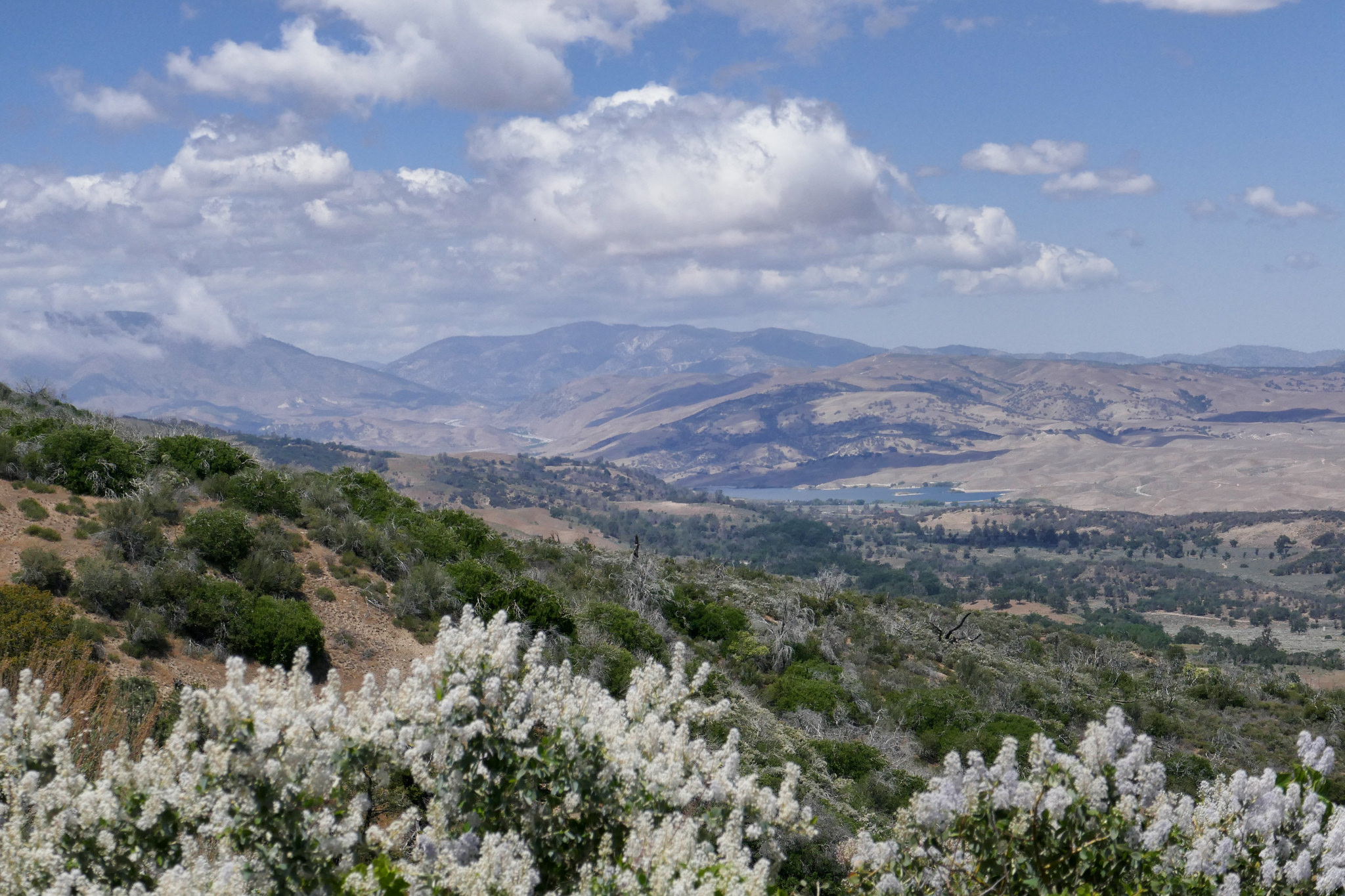
Today was a good day to brush up on our navigation skills and search for butterflies. The whole reason I started hiking to begin with was because I wanted to be able to photograph butterflies in the wild and not just the ones in my garden. So we did a leisurely loop hike from Jackson Lake to the Boy Scout Trail, then 3N26 to the PCT and returned along the Jackson Lake Trail. I had seen a lot of butterflies around some of these areas last year and wanted to see what was currently flying. The lupine was blooming and I saw many Boisduval's blues. There were also plenty of swallowtails, both pale and western tiger nectaring on the western wallflower at the Jackson Flat Campground. I also saw Pacific Azures. In addition to my search for butterflies, it was also a nice day to pull out the map, practice navigation and acquaint ourselves with the surrounding terrain. It’s been exactly one year since we started hiking and the more I hike, the more I realize how important it is to really know your paper map along with a compass and not just your electronics. Not to mention, having these skills opens you up to a world of other places to explore and not just the more popular routes. It was a day well spent.
Read MoreMount Pacifico 7,134', 2,398' +/-, 14 miles on the PCT from Mill Creek, June 3, 2018
I’m always looking to escape weekend crowds and find new trails to explore. This Sunday our hike was to the top of Mount Pacifico in the northern part of Angeles National Forest. We planned to start the hike at Mill Creek and follow the PCT which runs through this area. It looked like the trek would be around 12 to 14 miles depending on whether or not we did an out and back on the PCT or did a loop. The day was going to be hot, but I figured since we were heading up to a higher elevation, it might not be so bad on the ascent. If it got too hot, we would descend and save it for another time. The trail was very beautiful. There were many wildflowers and so much ceanothus (California lilac) which made for a very pleasant fragrance along the way. There was lots of wildlife activity too; squirrels, chipmunks, songbirds, bees, insects and butterflies. As we climbed higher, we started to see beautiful, tall pine trees. Much of the area was burned in the 2009 Station Fire, and we could see the effects of that as we hiked this route. But the area looks as though it’s been recovering nicely. Eventually, we reached a junction where we left the PCT and headed southeast to a jeep road that took us up to the summit. There are outstanding views of the surrounding mountain ranges along the way making the road more interesting. After about a mile or so we reached the summit. Mount Pacifico Campground is also here. There are picnic tables, a fire ring and vault toilets. That’s quite a luxury to have up on a summit! There are also a lot of very interesting rock formations to explore. There wasn’t anyone here today, so we took a good long rest and relaxed and enjoyed the peace and quiet. Soon it was time to head back and get ready for the heat as we descended to a lower elevation. We opted to come back the way we came on the PCT for a more scenic and enjoyable route. Both of us had been keeping well hydrated throughout the trip and we had no problems with it being so warm. We were even gifted with an occasional breeze as we hiked back down the mountain. I found this trail to be very nicely graded so although it was long, it was very pleasant. A very enjoyable hike!
Read More3 Peak Traverse: Mt. Baden Powell 9,406', Mt. Burnham 8,996', Throop Peak 9,137' via Dawson Saddle 10.4 Miles RT, 2,900' +/-, May 27, 2018
We wanted to try out a different route to Mount Baden-Powell, so we decided to start our hike from Dawson Saddle. It adds a little bit of extra mileage, but there are really great views along the route because much of this hike follows along the ridge once you reach the junction for the PCT. It's also less heavily trafficked then the route up from Vincent Gap. Since Baden-Powell was added to the Six Pack of Peaks Challenge, it's become increasingly popular. We actually only planned on hiking to Baden-Powell, but we had the time and decided to go up to Mount Burnham and Throop Peak which were close by. I should note that all of my photos were taken with my Android phone today. Somehow I managed to forget my camera which was a big disappointment because I love doing my photography along the way. I really enjoyed this route and trying out a new trail. After the hike we drove into Wrightwood for a bite to eat. On the way we passed by the trailhead at Vincent Gap and it was mobbed with cars! I couldn't believe how crowded it was. I was grateful we didn't go up that route today. Looks like we'll need to save the Vincent Gap route for a weekday when it's less busy. Baden-Powell is a lovely peak. It's also nice to say hello to the 1,500 year old Wally Waldron limber pine that sits on the ridge just below the summit. I'm sure he was pretty popular for photos today! It was another great day to be in the mountains!
Read MoreMount San Jacinto 10,834', 11 miles RT, 2,437' +/-, May 25, 2018
I took the day off on Friday so we could revisit San Jacinto Peak. We were thinking about hiking up from Marion Mountain, but first I wanted to try it again from Long Valley, so we made a fun day out of it by taking the Palm Springs Aerial Tramway way up to start the hike out at 8,516'. Just as I remembered, the San Jacinto Wilderness was absolutely breathtaking. Also, just as I remembered, the altitude kicked my butt! It was a slow and steady climb for me today, but with the beautiful forest and the amazing scenery I wasn't complaining about taking my time. As we approached the summit, the trail disappeared into the pile of boulders that I had been so nervous to climb last time we were here. This time, knowing what to expect, I had no problem. It was actually a lot of fun climbing up those rocks this time! We spent some time at the summit, had some lunch and enjoyed the expansive views. Hardly anyone up here today. It was so pretty with all the fluffy clouds passing just below the peak. After we were done soaking in the views, we began our descent and I made sure to take plenty of photos to remember the day. We hope to be back again sometime before the year is over to try this one from Marion Mountain.
Read MoreMount Baldy, 10,064', out & back on Baldy Bowl/Ski Hut Trail, 8.39 miles RT, 3,980' +/-, May 18, 2018
We were due for a visit to the top of good old Mount Baldy, so I took the day off on Friday to do it. This was our 3rd time to summit this mountain, and it’s always a nice challenge. We took our usual route up on the Baldy Bowl/Ski Hut Trail with a short break once we arrived at the Ski Hut. Then on we went through the Baldy Bowl boulder field and up through the steep switchbacks making our way through the pine forest and the short reprieve at the saddle. Then it was onto the manzanita maze of use trails to find our way to the top. Thankfully, the markers are all still intact since the last time I was up in December which made finding the trail easier. About a half a mile from the summit we stopped to chat and take a breather with a fellow hiker named Karen and her beautiful chocolate lab, Frankie. For the rest of the way, Frankie became my hiking buddy as she went back and forth between Karen and I. I could feel her nudge my leg with her head from time to time as if to say, “Come on lady! Hurry it up!” Soon enough, my husband who was ahead of us reached the summit and I was not too far behind along with Frankie and a moment later, Karen. No one was at the top but us! It was beautiful! The weather could not have been more perfect; sunshine and a nice breeze. I wandered around the empty summit taking my photos then sat for a bit to have a bite to eat and and chat with Karen and a few other hikers who had arrived. Eventually, all of them including Frankie headed down the Devil’s Backbone. Octavio and I were the only ones on top of Mount Baldy for a while. How cool is that considering the amount of traffic this summit sees! Soon it was time to begin our journey back. Instead of going down the Devil’s Backbone which has been our usual route, we opted for a change of scenery and decided to head back on the Baldy Bowl/Ski Hut Trail. We’d never seen it in the opposite direction before and although it’s quite steep, we wanted to give it a go. So down we went. The trek down was much harder than it was going up and definitely much steeper then going down the Devil’s Backbone. Thankfully, the scenery is so beautiful, it kind of takes your mind off your aching knees! We slowly made our way down trying as best we could to be careful not to slip on the sections of loose rock. We also had to be mindful not to lose the trail going through the manzanita maze just before reaching the saddle, as I’ve heard stories of people going off trail here and ending up in the bowl where there’s wreckage from a plane crash and then they had to climb their way back out. Finally, we made it back to the ski hut. We took a break here to rest our legs. As we sat, a very bold Stellar Jay came up pretty close to me to scope out my food situation. What a bum! You can tell the birds and also the chipmunks up at the summit are spoiled from so many people hiking here and feeding them their snacks. After our last rest, we began the final descent. It felt so good when we got back to Falls Road and I looked back up at the mountain we had just climbed. I wondered, as I often do, how we even make it up such a steep climb. I guess somehow you just do! It was another wonderful day on a most beautiful mountain!
Read MoreLiebre Mountain, 5783', 7.3 miles RT, 1,877 +/-, May 13, 2018
I was super excited to explore a new part of the Angeles National Forest this past Sunday! One of the first hiking books I’d ever purchased was “Trails of the Angeles” by the late John W. Robinson. This hike is hike #1 in his book. In addition, Casey Schreiner of ModernHiker.com, recently posted a trail report about this hike, making it sound even more appealing.
The trailhead is about an hour and 20 minute drive from our home and is in the northwestern section of the Angeles NF. It starts off on the PCT, and we did pass a number of thru hikers headed to the Sierras as we ascended the mountain southbound.
The first part of the trail took us up switchbacks that were surrounded by blooming ceanothus (wild lilac) as well as patches of yerba santa. As we made our way up, we had wonderful views of the Antelope Valley, the Ventura mountain ranges, the San Andres rift zone and the Tehachapis. It’s a very interesting contrast considering the mountain we were hiking on was so lush and green.
As we continued, we passed through an incredibly beautiful pine grove filled with purple lupines. Various wildflowers were numerous along the entire route. As we climbed upward, Liebre mountain turned into a sprawling oak savanna and the clouds began to roll over us as they made their way across the mountaintop. We reached a junction where the PCT headed east, but continued along the trail (which was now more of a fire road then a single track) to reach the highest point of Liebre Mountain. To find the high point which is marked with a wooden stake and a pile of large rocks, we had to leave the road and do a little searching. We stopped here to relax, have a snack and enjoy the scenery. We also did a some exploring around the top of the mountain before making our way back taking our time as we did. As we descended, the temperatures had warmed up a bit and there was more wildlife activity; lizards warming themselves in the sun and insects enjoying the wildflower blooms. I stopped for a while to get some photos of a Clearwing Hummingbird Moth nectaring on the yerba santa at about 4,300’. It was quite a sight! I’d never seen one of these before! This was a lovely hike and another great day to be in the mountains!
Read MoreLos Padres National Forest: Mt. Pinos 8,846', Sawmill Mountain 8,819', Grouse Mountain 8,582', 11 miles RT, 2,051 +/-, May 6, 2018
It was a beautiful overcast day in Los Padres National Forest. The weather at this higher elevation was a nice break from the warmer than normal temperatures we’d been having back home. Our plan was to hike to Mt. Pinos then Sawmill Mountain with the possibility of also climbing up Grouse Mountain if we felt up for it. We got to the trailhead just before 7:30 am and got started. The hike to Mt. Pinos took us through beautiful pine forests and wide open high elevation meadows. I can imagine how beautiful it must look here when more wildflowers are blooming. Mt. Pinos is easy enough to get to since it’s mostly hiking up a gentle fire road. At the top, there are some radio towers, but the views are great. It’s said that the Chumash Indians thought that Mt. Pinos was actually the center of the universe. Interesting that now we have a radio tower up there. After Mt. Pinos, we continued on the road to the Condor Observation Site. We didn’t see any condors today, but the views continued as we hopped on the single track Vincent Tunamait Trail and headed to Sawmill Mountain. The trail starts off with some long, gently graded switchbacks that make the descent quite enjoyable. You’ll be able to take in the surrounding views as you make your way down. Eventually that nice easy grade changes and the trail becomes steeper as you continue downward into the forest where it levels out again. I really enjoyed all the bendy Limber pines and also the vanilla scented Jeffery pines throughout this whole hike. After reaching the saddle, the trail climbed steeply upward and we eventually reached the spur trail for Sawmill Mountain. We made our way up to its wide, flat summit where there’s a really big rock carin with prayer flags that have been tattered by the winds. It was quite windy today making it a little chilly, but the views were incredible! We could see all the way out to the Sierras and could even spot Mount Whitney! Amazing! After Sawmill, we headed back down into the shelter of the forest and decided to continue on to Grouse Mountain. The trail descended again and eventually, we crossed the junction to Sheep Camp and a few other trails. Before long we found the spur trail heading up to Grouse Mountain. (The Vincent Tunamait Trail keeps on going and heads downward.) The spur trail to Grouse was steep and the trail was covered in soft pine needles, but it was easy enough to follow. At the summit, there’s a register hidden in the rocks that you can sign if you so choose. It was a lovely, peaceful place to break for lunch. After our break, it was time to start heading back. We knew we had a lot of up and down climbing left to do to get back to the car. It was an extremely relaxing day in this peaceful scenic forest and a very enjoyable hike.
Read MoreBig Morongo Canyon Preserve, April 29, 2018
Desert Adventures, Day 2 consisted of a visit to the Big Morongo Canyon Preserve which is easily accessed from the 62. You wouldn’t expect there to be so much green in the desert, but surprise! There’s lots of green here! This is because there’s a fault that runs through the canyon which causes water drainage from the surrounding mountains to form a marsh habitat. There are all kinds of birds here too; 254 species! If you’re a bird watcher, this is THE place to be!
There are trails here that are suitable for everyone. The Marsh Trail is an easy boardwalk that winds along the stream. It’s shaded by beautiful cottonwoods and willows. Yes shade! In the desert!! Lots of wildlife activity can be seen and heard here. The Yucca Ridge Trail takes you up to a higher elevation and is more exposed. From here you can look down into the preserve’s wetlands to appreciate just how green and lush it is. You’ll also have wonderful views of the surrounding peaks of Mount San Jacinto and San Gorgonio. If you have time and are looking for a longer hike, you can take the 9.76 mile round trip Canyon Trail. We didn’t have time to do this today, but I’d love to go back and try it when the weather is cooler.
To get an overall perspective of the preserve, we did a loop around it - Desert Willow Trail to Yucca Ridge to West Canyon Trail to Mesquite Trail and a loop around the Marsh Trail. There are maps and information at the kiosk at the trailhead. We saw so many critters en route, including a snake crossing over the trail. There were also many wildflowers in bloom. It was an enjoyable and relaxing way to wrap up the weekend.
Read MoreMojave National Preserve, Kelso Dunes, Amboy Crater, Joshua Tree National Park, April 28, 2018
Our desert adventures started with a trip to the Mojave National Preserve to hike the singing sands of the Kelso Dunes.
The hike starts out on a sandy track that heads straight. As you hike, the terrain is mostly flat until you get closer to the dunes where you’ll begin to cross many smaller dunes before arriving at the base. There really isn’t an established trail because the wind is constantly shifting the sand, but you can make out footprints where others have made their way up. Just keep heading towards the highest point, and try to avoid stepping on any vegetation. As you begin to ascend, hiking becomes more strenuous. Your feet sink into the deep sand and for every step you take forward, you’ll slide two steps back. It’s no easy task, but getting up to the top is totally worth it! Once you’re on top, follow the sandy spine all the way to the peak where it levels off. You’ll have a great place to sit and enjoy the surrounding views.
Now for the best part… When you’re done taking it all in, you’ll can slide your way down! If conditions are right, you’ll hear the dunes boom or sing and feel them vibrate underneath you. This phenomena is caused by sheets of sand cascading down and rubbing against the stationary sand below. It’s really something to experience and there are only 30 other dunes in the world that can do this. I was elated that we were able to hear them sing today!
Our next stop was Amboy Crater National Natural Landmark, just off Route 66. The crater is a cinder cone type of volcano that last erupted about 10,000 years ago. To get to it, you hike through a lava field and then up and into the crater where you can walk around its edge. It’s about a 3 mile round trip hike. Sadly, we were unable to hike all the way up today because the temperatures were already a scorching 90 degrees. It was still fun to see and it’s on our list for when the weather cools down.
After the Amboy Crater, we made our way down to Twentynine Palms where we spent the night. We had some dinner before heading into Joshua Tree National Park to relax and watch a gorgeous desert sunset before retiring for the evening.
It was a great day! I’m really looking forward to exploring more of the Mojave National Preserve. There’s so much to see!
Read MoreStoddard Peak, 4,324', 6 miles RT, 1,145' +/-, April 22, 2018
We thought we’d try one of the other hikes in the Mount Baldy area this past Sunday, so we choose Stoddard Peak. This hike starts off as an easy hike along a scenic fire road, but once you arrive at Stoddard Flat, get ready to do some bushwhacking, rock scrambling and climb over two false summits to get to your final destination. Once you reach the peak, the views are awesome. We had a perfectly clear day and a spectacular view of our majestic Mount Baldy. Being this is not one of the more popular hikes in the area, we only saw a few other hikers along the way and had the peak to ourselves. It was a fun day!
Read MoreStrawberry Peak via Redbox, 7.5 miles RT, 1,752’ +/-, April 20, 2018
Strawberry Peak is the tallest peak in the front range standing at 6,164’. It’s easy to spot along Angeles Crest Highway because it’s shaped like a Strawberry. We took the trail from Redbox, but there’s also a mountaineer’s route with a class 3 rock climb that you can access via Colby Canyon. We opted for the “easy” route. This was a fun hike which at times tested my fear of heights. Steep rock scrambles are more of a mental challenge for me then a physical one, so I had to push through some fears getting myself up there today. The expansive views as you hike along the ridge and make the steep climb to the top are absolutely worth the effort. And who knows, maybe someday I’ll work up the courage to do the mountaineer’s route! It was a fun, challenging and exciting day!
Read MoreSunday's 2nd Hike: Wildlife & Wildflowers at Grizzly Flat, 2.4 miles RT, 643 +/-, April 15, 2018
On the way back from Devil’s Canyon today, we stopped off at Grizzly Flat so I could take some butterfly photos with my DSLR. I don’t hike with my DSLR anymore because it’s too cumbersome on strenuous hikes. I also don’t want to ruin it when I need to climb up rocks or navigate through tall brush. I brought it along today just for this hike since it’s an easy one up a nice, wide trail. The sun was in and out so it was mostly cloudy, but the hike was very nice. There were lots of wildflowers in bloom, hence the butterflies were around them. I didn’t see a lot of activity today, but I did see a few as well as some other critters in the short time we were on the trail. One of these days I’d like to hike up this trail a little further although it’s hard when you’re searching for butterflies because you end up spending a lot of time just in one spot waiting for that perfect shot!
Read MoreDevil's Canyon, 5.3 miles RT, 1,357 +/-, April 15, 2018
We’ve been doing a lot of canyon hikes lately. Devil’s Canyon was another one I’ve had on my “to do” list since we’ve been driving past it on the way to other hikes. The trail takes you down into the rugged San Gabriel Wilderness. It follows a babbling brook into the heart of Devil’s Canyon where it opens up to flat, sandy trail next to sparkling pools, cascades and smooth boulders that make a great place to have lunch. There’s also a primitive backcountry campground that you can stay at just a little further up the trail. I liked this hike a lot. The trail is quite narrow in many spots so you need to stay focused, but it’s not sketchy. The grade is also gradual, so climbing up isn’t so bad since you’ll gain all your elevation on the way out.
Read MoreTrail Canyon Falls, 4.5 Miles RT, 981' +/-, April 8, 2018
It was 6:30 am Sunday morning and we were on the trail headed to Trail Canyon Falls, a beautiful waterfall cascading 30 feet down into a rugged canyon. What this hike lacks in distance, it makes up for in beautiful scenery. The trail to the falls winds through the canyon and crosses the creek several times before heading up to the top of the waterfall where you’ll have spectacular views looking straight down. If you’re feeling adventurous you can also descend a steep use trail where you can rock scramble your way down with the help of a rope tied to a tree to get to the base of the falls. Today the water was flowing beautifully, the wildflowers were blooming and butterflies were on the wing. Since we started so early, we shared the falls with only two other hikers. It was a very peaceful morning. As we headed back, I came upon a very hungry swallowtail who was so busy nectaring on Western Wallflower that he didn’t seem to mind me hovering over him with my camera to take some photos. Also, if you keep your eyes peeled, there’s a picnic table nestled away in the shade off to the side of the trail that makes for a great place for a snack break or even a picnic. We stopped there for a bite to eat before finishing up the hike. It was an absolutely perfect day with temperatures at about 65 degrees at 10:30 am when we arrived back at the trailhead.
Burkhart Trail from Devil's Punchbowl, 12 miles RT, 3,038' +/-, April 1, 2018
The Burkhart Trail from Devil’s Punchbowl has been on my bucket list ever since the first time we hiked to Devil’s Chair and the Punchbowl loop. I wanted to get this one out of my system before the weather got too hot knowing that much of the trail is exposed. This hike is kind of like two for the price of one. It has a lot of diversity along the way taking you from the desert floor to the alpine zone. The first part of this hike drops you down to Cruthers Creek which is lower then the elevation from which you started at the trailhead. This section is a beautiful trek unto itself, but you have to remember to save some fuel in the tank since you’ll have to hike back up out of the canyon later on. Next, you cross over Cruthers Creek and from here on out it’s a long, steep haul toward Burkhart Saddle. Personally, I didn’t find the climb all that difficult. BUT… what I didn’t expect were the lengthy sections of trail with loose rock on sometimes very narrow and mostly exposed slopes. This trail has all kinds of terrain to hold your attention from beginning to end. We encountered soft sand, loose scree, talus, and pine needle covered track. I really enjoyed hiking through the different plant communities in this unique transition zone. As we continued onward and upward, there was a nice, cool breeze coming up out of the canyon to keep us comfortable. The higher we went, the more the temperature cooled and trail seemed to become more and more rocky with very few breaks in between. At about 6 miles in, just one mile short of the saddle, we hit our turn around time. We looked over at the saddle which seemed so close, yet so far! Then we looked at the trail ahead of us... More rock! Ugh. We contemplated making the final push anyway, but we both agreed it would be even more slow going on the way down and decided we should start heading back. We also still had to make the climb up out of the canyon. Carefully we negotiated our way down the slope. My trekking poles came in handy here. When we arrived back at the creek, I got distracted by all the little Lotus Hairstreak butterflies. I spent some time chasing them around trying to get a good photo. (Or maybe I was just procrastinating the climb back up.) As I tried to focus my camera on the tiny green butterfly who was posing so patiently on a leaf, a hummingbird mistook my bright fuchsia tee shirt for a flower. He swooped so close I could feel the flutter of his tiny wings. He swiftly flew away when I looked over my shoulder at him and he realized he was mistaken. As we began the final climb up out of the canyon a hazy cloud cover kept the sun at bay, and I enjoyed snapping photos of the ever changing scenery on the trek back to the trailhead. Overall, I really enjoyed this hike and would do it again. Perhaps next time we’ll start a little earlier now that we know what to expect with the rugged terrain.
Read MoreCloudburst Summit to Cooper Canyon Falls via Pacific Crest Trail, 7.5 miles RT, 1,739’ +/-, March 25, 2018
What a great weekend to chase waterfalls! We took advantage of the recent rains and snow melt and set out to hike to Cooper Canyon Falls. From Cloudburst Summit we picked up the PCT. This hike is an “upside down” hike so you gain all your elevation on the way back. The trail starts off by dropping you down into the canyon and takes you through the Pleasant View Ridge Wilderness. The views are quite lovely as you make your way around Winston Peak. Eventually, you’ll reach Cooper Canyon Trail Camp. We hiked past the camp and continued on the PCT to the junction with the Burkhart Trail (another really pretty trail and actually a shorter route to the falls.) From here you have to keep your eyes peeled and find one of the use trails that will take you down to the bottom of the falls. The trails are very steep, but there’s a rope tied to a tree to assist with the final few feet of rock scramble. The waterfall was absolutely beautiful today. When we were here last summer, it was barely a trickle. After we’d gotten our waterfall fix, we found a nice spot in the warm sunshine and had some lunch before heading back.
Read MoreSnow Hike #2, Waterman Mountain 8,038’, 6.13 miles RT, 1,332 +/-, March 18, 2018
Sunday was another beautiful day for a snow hike. Although it was a little warmer than the last snow hike we did a few weeks ago, there was still plenty of snow to turn the forest into a magical winter wonderland. We packed our winter gear and headed up to Waterman mountain. We know this mountain pretty well by now, and I feel safe here. The trail is easily graded and there aren’t many narrow sections. There’s also an option to hike up a fire road if you so choose. We took the Waterman Trail from Buckhorn just off Angeles Crest Highway. The day started off with blue skies and few clouds, but by the time we finished more clouds were rolling in. There was a lot of water flowing from the rains we just had which formed beautiful icicles. The pines were heavy with pure white snow which made me feel like we were walking through a scene from a winter fairy tale. As last time, this trail was so quiet and peaceful. We took our time making our way up to the summit and enjoyed the picturesque forest. I'm not sure if we’ll get to experience this again this year since it’s just about Spring, but it really was wonderful and I can’t possibly think of a better way to spend a Sunday.
Read MoreJosephine Peak, 555,8', 8 miles RT, 1,841 +/-, March 11, 2018
We had quite a bit of rain over the past two days, but it wasn’t cold enough to bring the beautiful snow down to the lower elevations like we had last weekend. I didn’t want to take my chances slipping and sliding on muddy trails or contribute to trail erosion, so today seemed like a good day to check out Josephine Peak which you can get to by hiking up a fire road. As we drove up Angeles Crest Highway, we could see the clouds nestled in the mountains. There were patches of fog, but the visibility was still pretty good. We started the hike just across from the Clear Creek Ranger Station. The mountains looked so beautiful surrounded by the passing clouds. I spent a lot of time taking photos of it all as we hiked up on a nice steady grade. As the trail looped us around Josephine’s north face, the scenery got even prettier. Finally, we reached the single track that would take us straight up to the peak. Once at the top, we were engulfed in the clouds. There wasn’t much visibility, but just for a moment the clouds broke up a little and I was able to get some great photos. I’m glad I took a lot of pictures on the way up because as we headed down, the fog really began to roll in and I could barely see anything as far as views. I decided to have some fun by taking photos of my husband as he disappeared into the foggy mist. It felt like we were walking in a dream. The weather definitely made this one interesting!
Switzer Falls, Bear Canyon Trail Camp, 7.26 miles RT, 1,450 +/-, March 9, 2018
Our destination today was Switzer Falls with the option to continue on to Bear Canyon Trail Camp. This was such a fun hike with a lot going on! The hike to Switzer Falls starts off at the Switzer Picnic Area and follows the beautiful Arroyo Seco. The canyon is shaded by oak and alder trees, and the wildflowers were beginning to bloom. The trail eventually climbs out of the canyon and takes you up onto a sheer cliff where you can look across to see the ruins of an old chapel which was once part of a wilderness resort called Switzer-land. Next, you’ll drop back down into the canyon and follow some switchbacks to a junction with the trail to Switzer Falls and the Bear Canyon Trail. We hiked over to the falls first. There was no one there today, so we sat for a while, had a snack and enjoyed the sounds of rushing water. After the short break we made our way along the Bear Canyon Trail. This trail was definitely not as well maintained as the trail we had been on previously; however, it was definitely passable. We had to do some boulder hopping, route finding and navigating up and over downed trees. There were a lot of stream crossings on this trip. I counted 58 total there and back. It was an obstacle course for sure, but that’s what made it so fun! We passed by many fish pools and small cascades. I couldn't help myself. I just had to stop, take off my hiking boots and go wading in one of the pools. The water was cold, but refreshing. Eventually we reached the backcountry Bear Canyon Trail Camp. This campground is very remote. It has some picnic tables and wood burning stoves but not much else. We sat for a bit and enjoyed the peace and quiet before heading back the way we came. We didn’t see a single soul until we reached the junction with the falls. Just the way I like it! It was another beautiful day well spent!
Read MoreSnow Hiking on Waterman Mountain, 2018-03-04
What an incredible day in Angeles National Forest! I was hoping to get to see more snow before the winter was over, and today I got my wish! I woke up at 5 am and we headed up Angeles Crest Highway just after the sunrise. I didn’t want to leave too early not knowing what the driving conditions would be like. As we got higher up in elevation, we started to see the snow. The roads still had a very light covering, but the driving was fine and there was no ice. It was beautiful just driving along the highway. Our destination was Waterman Mountain. This trail is one of my favorites in the summer and seeing it for the first time in winter was a treat! The pine trees were heavy with snow and icicles. The forest was incredibly serene and peaceful. The only sounds we heard were the birds singing and the ice melting off the majestic pine trees. The air was fresh and the sky was crystal clear. It was a bluebird day for sure. Today was also the first time I’ve ever had the opportunity to photograph snow. When I lived in Pennsylvania, I hadn’t gotten into photography yet. Also, I was just so used to having snow in winter, that I really didn’t think much of it. Well that sure changes when you don’t get to see it anymore. I could not have asked for a more perfect day.