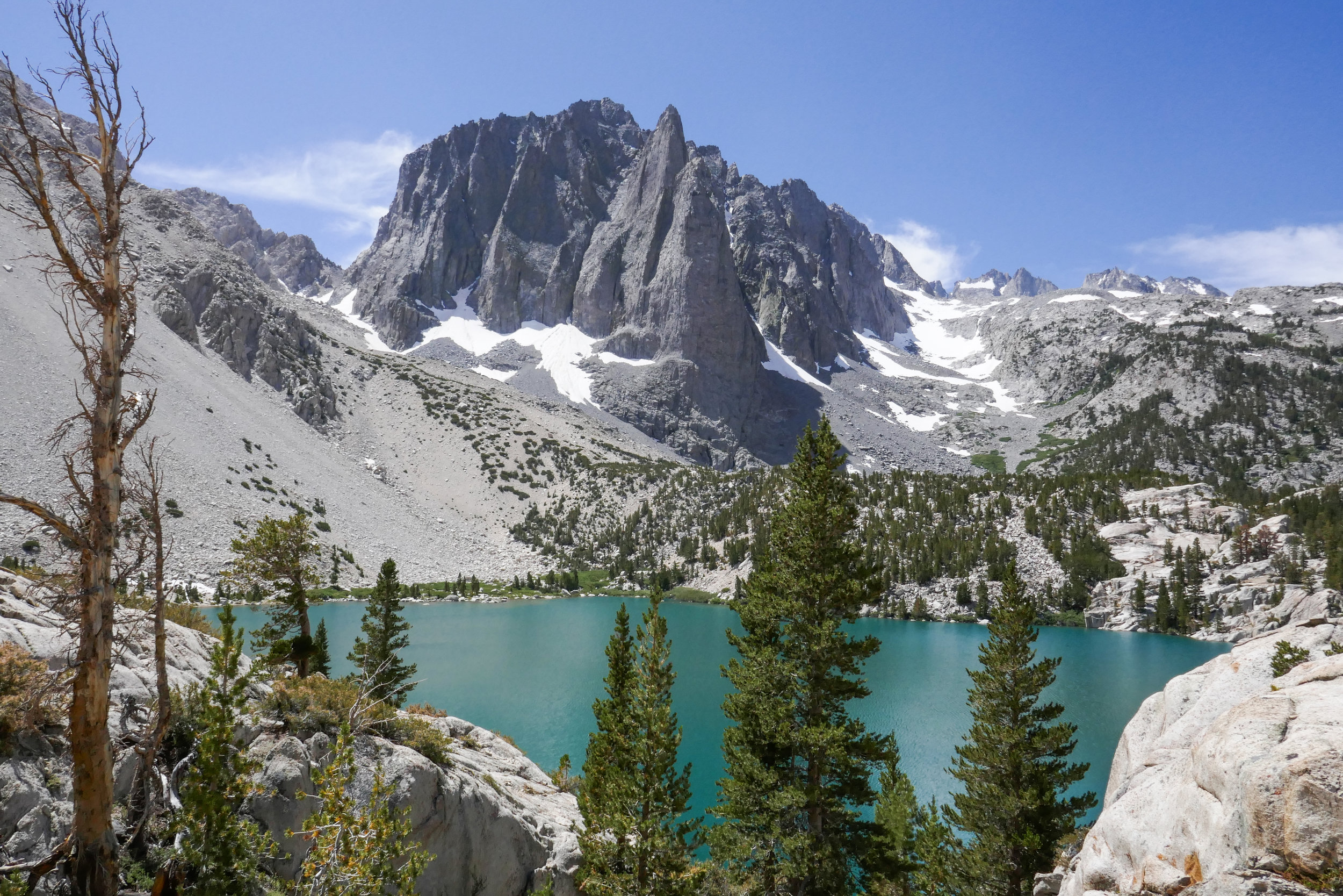
Our hike to Big Pine Lakes in the Eastern Sierra was one of the most beautiful hikes I’ve ever been on. There are seven lakes total and on this day, we hiked to the first three via the North Fork Trail. Since we weren’t backpacking, I had much less weight to carry then when we were in the Eastern Sierra last month backpacking the Mt. Whitney Trail. Most of the Big Pine Lakes hike follows along Big Pine Creek. We were next to the beautiful rushing waters most of the day. Early in the morning when we first got on the trail, we saw two doe and a fawn crossing the creek. There were plenty of wildflowers and butterflies to enjoy throughout the day as well. I took my time on this hike and spent a lot of time taking photos of it all. When we reached lake one we saw Temple Crag (popular with alpine rock climbers) towering over the incredible turquoise waters. The turquoise color comes from the glacial powder of Palisade Glacier. I also saw some trout swimming in the lake. This was a wonderful hike. We had to do some work climbing up in elevation to get to the lakes, but it was well worth the effort because the scenery was spectacular.
Read MoreMt. Whitney
Backpacking the Mt. Whitney Trail, July 15 & 16, 2019, 11 Miles RT, Elevation +/- 3,225', Max Elevation 11,000'
This was my and my husband’s first time hiking the Mt. Whitney Trail past Lone Pine Lake and our very first backpacking trip. We didn’t plan to summit due to the trip reports of snow traverses beyond our skill set and comfort zone. We weren’t in a hurry and we didn’t put any pressure on ourselves. The only goal we had was to gain experience, enjoy an evening on the mountain and return home safely.
I’d been reading trip reports from other hikers and keeping track of trail conditions for weeks. With the big snow year we’ve had, I needed to be aware of what to expect on the trail. The first obstacle we encountered was a water crossing just before the John Muir Wilderness boundary. It was flowing strong, but I found it easy enough to cross. I removed my boots and hiked across in sandals. I did the same on the return, but my husband chose to rock hop and we both were able to get across with no problems. It was actually a lot of fun.
We hiked up the first set of switchbacks slow and steady. I kept my pace in synch with my breath. I carried 28 lbs. My husband had 33 lbs. We had no problems with weight. Both of us workout regularly, so we both have a good level of fitness. We are both going to be 50 years old this year.
For our first night, we planned to sleep at Outpost Camp. Both of us felt great when we arrived. We even felt like we could have gone farther, but I didn’t want to risk AMS.
Our plan to acclimate was the following: Saturday, spend time at Horseshoe Meadow, sleep in Lone Pine (enjoy hotel facilities such as plumbing and a shower!), Sunday, hike the Ancient Bristlecone Forest, sleep again in Lone Pine, Monday hike and sleep above 10,000’ at Outpost camp.
Monday night we had Outpost Camp all to ourselves aside from one other couple. The star filled night sky was amazing and the moonlight reflecting on the granite walls surrounding us was beautiful. We fell asleep to the sound of the nearby waterfall. Well, my husband fell asleep. I actually didn’t sleep all that much, but I never sleep well when camping. The only other issue I had was the bugs. Lots and lots of mosquitoes!!!
In the morning, there was a doe wandering around camp. I watched her for a while as my husband made breakfast. I didn’t have much of an appetite, but other then being tired from lack of sleep, I didn’t have any signs of AMS. After breakfast and decided to leave our gear at Outpost camp. We planned to hike up as far as we could get with lighter daypacks, then return to Outpost camp and decide whether or not to spend another night there or drive back to L.A.
I was pretty tired when we first got going. We continued up the trial and just past Mirror Lake we encountered a very short snow bridge with footprints going left and right. The trail here was actually almost covered, but you could kind of see the rocky steps to the right which is the way we went. We had to do some route finding between that section above Mirror Lake and Trailside Meadow where it got a little confusing. We came prepared with navigation tools. I carried a paper map, compass, a Garmin inReach Explorer and my husband had a Garmin Fenix 3.
We kept on hiking until we reached Trailside Meadow. It was amazing to be above the timberline! At this point we were both satisfied with how far we had come. We could have continued on, but decided to turn around. Both of us wanted to make sure we had enough energy left to hike back down, pack up our things at Outpost camp, then hike out and make the drive back to L.A.
Even though we didn’t reach the summit, I feel accomplished. We gained experience, had a great time, returned safely and got to know the majestic Mt. Whitney a little bit better.
Read MoreMt. Whitney Trail to Lone Pine Lake, 5.8 miles RT, 10,032' Max elevation, 1,824' +/-, August 20, 2018
We only had two short days to spend in the Eastern Sierra, so on the second day after having hiked to Kearsarge Pass the day before, we decided upon something shorter since we’d be heading back to Los Angeles on this day. I knew the hike to Lone Pine Lake on the Mount Whitney Trail was only about 5.8 miles round trip, and although I am not always keen on hiking busy trails (this one probably being the most popular trail in all of California) I decided to suck it up and give it a go.
On Saturday the day we arrived, we actually drove up to the Whitney Portal just to check it out. I have to admit I was pretty starstruck knowing that every year about 30,000 people try for the summit of the tallest peak in the lower 48. Just for fun, we weighed our backpacks at the weigh station, and my day pack weighed in at 15 pounds.
On this Monday morning as we began the hike to Lone Pine Lake, the first section of the Mount Whitney Trail reminded me very much of a typical Southern California hiking trail. The grade was steady and not too strenuous as we ascended through pine trees, passed by wildflowers, a grazing doe and crossed over a few streams. We were surrounded by the towering walls of majestic granite cliffs that opened up to views down into the Owens Valley, Alabama Hills and White Mountains off in the distance. At about 2.8 miles we reached the junction for Lone Pine Lake and followed the trail to the shores of the lake’s stunningly beautiful cobalt blue waters. After spending some time exploring the lake, we hiked a little further on the Mount Whitney Trail to the posted sign for the permit only Mount Whitney Zone even though we knew we would not be going any further today. As we looked longingly up trail towards Outpost Camp, several groups of hikers passed us crossing over into the zone with their permits hanging from their backpacks like little battle flags. I could not help feeling a bit jealous wishing I were one of them, but also knowing I would not want to attempt hiking Mount Whitney in just one day. On this trail, my husband and I made a pact that we would start collecting the gear and learning how to backpack. It’s something we’ve been thinking about for a while now, but seeing this mountain in person for the first time seemed to inspire us to get the ball rolling. Perhaps someday we too would be one of the many hikers who journey to the top of this peak, but for today we would just take it all in before it was time to head back home leaving the Sierra until next time.
Read More