Some photos from a short walk around Hickory Run State Park on Christmas Eve. It was a beautiful day and the snow was fresh and powder.
Click “read more” below for more photos.
Read MoreOpt Outside
Some photos from a short walk around Hickory Run State Park on Christmas Eve. It was a beautiful day and the snow was fresh and powder.
Click “read more” below for more photos.
Read MoreWe started our day with an early morning hike on the New Jersey side of the Delaware Water Gap National Recreation Area. We parked at the trailhead for Blue Mountain Lake and planned to hike to Hemlock Pond and then on to Crater Lake, a natural glacial lake left behind from the Wisconsin Glacier approximately 22,000 years ago. It was a beautiful spring morning. The sun was shining and the birds were singing as we headed onto a wide, grassy path which was once a former road for a housing development. The easy trail took us along the northern side of Blue Mountain Lake offering lovely views along the way. At about 2.5 miles, the mostly hardwood forest became a green canopy of tall hemlocks. Soon we reached the shores of Hemlock Pond. The landscape here was incredibly picturesque. We spotted a milk snake sunning itself on the rocks and also noticed a den full of black snakes which if I had to guess were either water or rat snakes. After taking in the scenic landscape and the wildlife, we continued around Hemlock Pond until reaching the connector trail to Crater Lake. The trail made an ascent on a rocky, single track before reaching the Appalachian Trail where we found a vista point with some views. From here we began to circle around Crater Lake then followed a short spur trail down to the shores for a closer look. We then continued on the main path and found Lake Success on the southeast side. The banks of Lake Success were filled with fragrant Lily of the Valley. I know these are not native, but the aroma is amazing and they are also one of my favorite flowers. In the middle of the lake I spotted a beaver dam. As we continued the loop, we crossed the trailhead and parking area for Crater Lake. There were some inviting picnic tables here, so we decided to sit for a bit, have a snack and enjoy the peaceful setting before moving on. When we were ready, we got back on the trail and headed back towards Blue Mountain Lake. This time we hiked along the inner loop trail which took us directly to its peaceful southern shores. I couldn't believe there wasn’t any one here except for one lone fisherman who we had seen at the trailhead very early in the morning. It was such an amazing day. We ended up hiking a little over nine miles which always seems to go by so fast when there’s so much beautiful scenery.
Click on “Read More” below for more photos.
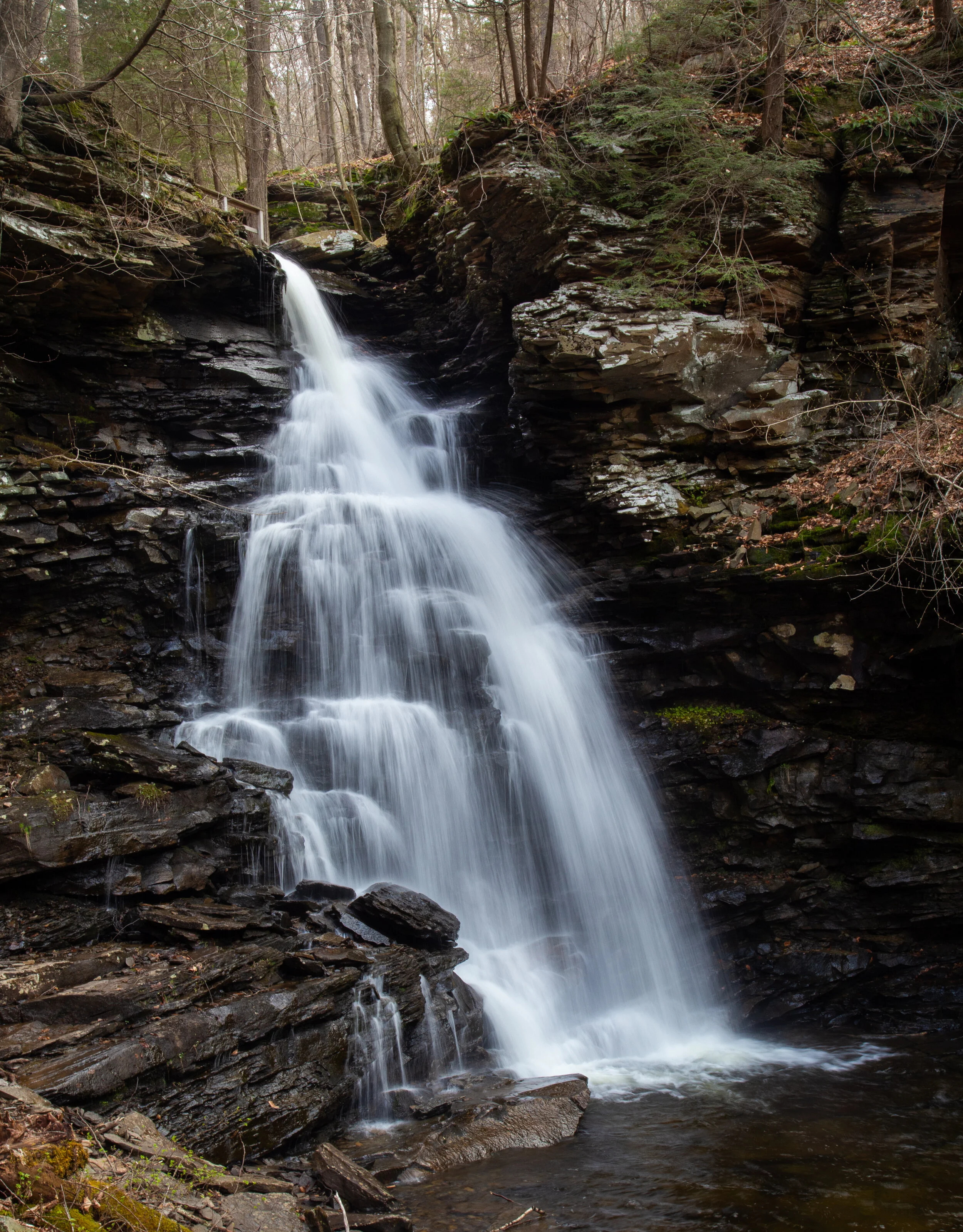
Read MoreRicketts Glen State park is home to the Glens Natural Area, a National Natural Landmark in Pennsylvania. The Falls Trail system that we hiked today consists of 21 incredible waterfalls that flow between steep, narrow valleys known as glens. The tallest waterfall on the circuit, Ganoga, is 94’ impressive feet. Ricketts Glen State Park is one of the most scenic hikes in Pennsylvania. It’s named after Colonel R. Bruce Ricketts who bought land in northeastern Pennsylvania for timbering. When fishermen exploring Kitchen Creek found that there were waterfalls flowing through the deep gorges, Colonel Ricketts spared the land. He hired six men to build the trail system in what is now known as the Glens Natural Area and the project was completed in just four years. Each of the 21 waterfalls has a name. Colonel Ricketts named them after American Indian tribes and also his friends and family.
We began our hike at the trailhead off the 118. From here we had a pleasant walk along Kitchen Creek on a flat path before reaching a junction for the lower and upper trails. The lower trail was marked as difficult, and the upper trail was marked as moderate. Of course we opted for the lower, more difficult path. Both trails meet back up again at waters meet before the beginning of the Falls Trail Loop. The lower trail hugged the creekside going up and down muddy, slippery terrain. It wasn’t particularly difficult, but we had to watch our footing. Soon, we started to see the waterfalls. There are three falls before you reach waters meet: Murray Reynolds, 16’, Sheldon Reynolds, 36’ and Harrison Wright, 27’. All three were absolutely beautiful. When we reached the junction at waters meet, we opted to hike up the Glen Lehigh side first. There are eight waterfalls on this side ranging from 15 to 60 feet. We made our way up the steep rocky gorge crossing over bridges that took us right up and over the top of the falls. It was a spectacular trail which varied between flat, rocky sections along the creek and steep climbs up rocky steps. We stopped at each fall to take photos and spent time enjoying the uniqueness of each waterfall. Once we completed the traverse up the Glen Leigh side, we got on the Highland Trail heading west. The Highland trail would take us to the Ganoga Glen side to see the next set of falls. The Highland Trail was mostly flat, quiet and very peaceful. It took us through a beautiful forest of pine and along the trail I noticed a wooden bench for sitting and taking in the serenity of the forest. About half way through this section of trail, we reached some giant rock formations and passed through two large boulders called the Midway Crevasse. Soon, I began to hear the sound of rushing water again which meant we were coming up on the next set of falls. We crossed over a bridge and were soon making our way down the gorge on the Ganoga Glen side. The rocky steps were muddy and slippery. We had to take extra care coming down the steep sections, as I think it’s harder coming down then it is going up because it’s easier to slip. We passed by three lovely falls before reaching Ganoga, the 94’ waterfall. It was absolutely stunning. As we continued down the Ganoga Glen side, we began to see more people coming out to enjoy the trail. At this point I sort of lost track of which waterfall we were passing and I was spending more time looking at the smaller details like the Trillium blooming alongside the trail, the green fern and bright moss growing above the gorge. There is so much to take in on this trail besides the just waterfalls. When we reached the junction for the upper and lower trails, we decided to take the upper trail for a change in scenery. The trail was an easy flat path that travelled high above Kitchen Creek. Along this trail I saw more blooming Trillium. By now it was early afternoon and the sun had started to come out. The weather up until this point had been cloudy and we even had a light sprinkle of rain. When we reached the final mile that would take us back to the trailhead, I noticed some blooming Trout Lily. It was a wonderful day and Ricketts Glen Natural Area is a really special place.
Click on “Read More” below for more photos.
Read MoreI’m finding some really great nature preserves here in the Keystone state. This past Saturday we ventured off to explore the Nothstein Preserve located in Paradise Township in Monroe County. The hike took us through a variety of different terrain, along the ravine of Cranberry Creek and up to a red rock quarry with views extending from east to west across the ridge to the surrounding preserves. We started at the trailhead off Cranberry Creek Road and headed north on a wide path in a counter clockwise direction. The forest was mostly hardwood dappled with tall hemlock trees. Immediately my ears were filled with the pleasant harmony of morning birdsong. We passed by marshes, bogs and small tributaries until we reached a primitive bridge crossing over the pristine waters of Cranberry Creek. We took a moment to branch off and explore its banks and the surrounding feeder creeks before continuing on a single track where we began to ascend gently upward. The trail reached an intersection where we turned northwest. I spotted some train tracks above us running parallel to our path. We made several primitive creek crossings over the crystal clear waters flowing down the mountain and over thick, bright green moss. Now the trail began to descend southwest. The forest became dense with hemlock, and I could hear the sound of rushing water flowing just beyond the trees. The path opened up to reveal another bridge crossing over the fast moving Cranberry Creek. Lined with rhododendron just beyond the bridge, the terrain became a snow covered single track leading us upward above the ravine. We made our way up the trail being careful on the icy patches of snow until reaching a vista of the beautiful cascading waters below. I made sure to get some photos from above, but I wanted to take a closer look. We then backtracked and made our way to a section of trail following along the edge creek where we could enjoy a closer perspective of the sights and sounds of the waterfalls and tumbling cascades. Eventually, we backtracked crossing over the bridge once again and up through the hard packed snow back to the top of the ravine. Soon, the trail began to move away from the creek and the forest became even more dense with tall stands of hemlock and oak. We crossed over more small tributaries being careful not to slip on the moss covered rocks. I’m not sure if it was the tall stands of pine or the way the sunlight was shining through, but this section of trail reminded me a little bit of my beloved Angeles National Forest. It was another lovely section of trail. The path widened again and took us under a canopy of pine. The trail became a bed of soft pine needles beneath our feet. As we travelled up the slope we were led to an old stone red rock quarry. Two large ravens suddenly emerged from the trees and soared across the blue sky above. Again, I felt at home as I was reminded of my life in California where there were always ravens to accompany me along my hikes in the higher elevations. As we traversed along the edge of the quarry, we were treated with sweeping views across the gorge and the ridge beyond. I was awe struck at how a place so beautiful can be so close to civilization. We spent some time exploring around the quarry before moving on, back into the hardwoods and finally looping back down to the woodland path on which we started. It was an absolutely amazing day and a beautiful preserve full of wild, natural beauty to explore and admire.
Click on “Read More” below for more photos.
Read More