Jacobsburg State Park is a great place to go when you just want to get out and enjoy some fresh air. Took my Canon with me today and got some nice photos on the Hazard Trail.
Click “read more” below for more photos.
Read MoreNortheaster Pennsylvania
Jacobsburg State Park is a great place to go when you just want to get out and enjoy some fresh air. Took my Canon with me today and got some nice photos on the Hazard Trail.
Click “read more” below for more photos.
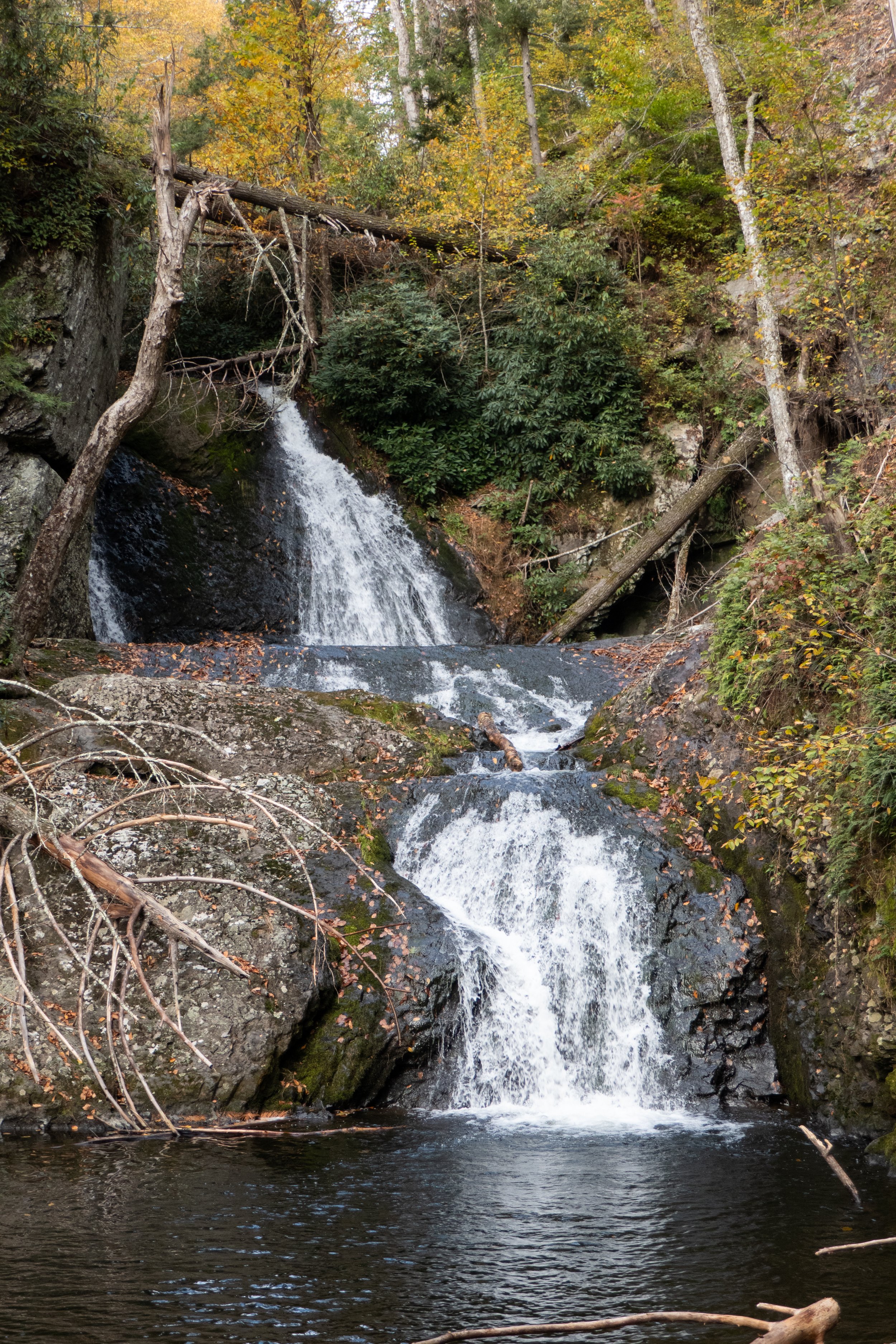
Read MoreAfter hiking in the Adirondacks where it was mostly past peak foliage, we were able to catch the some of the colors spreading south through Northeastern Pennsylvania. We hiked the Delaware Water Gap National Recreation Area from the trailhead at the Pocono Environmental Education Center. We first took the Two Ponds trail to Tumbling Waters falls, then back to the parking area where we picked up the Ridge Trail that looped us through Scenic Gorge. Some fun, easy rock scrambles on this hike and pretty scenery made for a nice, relaxing day.
Click on “Read More” below for more photos
Read MoreToday we headed out early to explore the Delaware Water Gap National Recreation Area. Our first stop was Dingmans Falls. This is a popular area with a beautiful boardwalk system that provides safe and easy access leading to two beautiful waterfalls. I was aware that this is a popular destination and can become quite busy, so we arrived just after sunrise. The road to the parking area at the Dingmans Visitor Center was closed (they close it during winter), so we parked in the lot just off the 209 and began a short mile walk down Dingmans Falls Road to the trailhead. The road itself was very scenic as it followed Dingmans Creek past tall pines. As we strolled along I saw a lot of downed trees which I later learned were caused by a violent storm in 2018. Soon we reached the Dingmans Falls Visitor Center where the smooth boardwalk trail begins. It crossed over Dingmans Creek and within just a short distance we were treated to a view of our first waterfall of the day, the 80 foot Silver Thread Falls. Silver Thread is tall, narrow and drops over the rocky cliffs in almost a perfectly straight line; hence the name “silver thread”. As we continued on the boardwalk we passed through large stands of rhododendron surrounding us on either side. It gave the trail a jungle-like feeling. In less than a mile we arrived at the majestic 130 foot Dingmans Falls. This waterfall is noted as being the second tallest in Pennsylvania; the tallest is Raymondskill Falls just a few miles up the road. The fast flowing waters tumbled down a gorge carved into exposed bedrock from the Devonian period 365-405 million years ago. We spent some time taking photos and enjoying the views before making our way up a steep wooden staircase to the top of the falls. The views from above were just as spectacular as below as the water spilled down the 130 foot vertical drop. After taking in the scenery and making sure to grab lots of photos, we decided it was time to start heading back so we could enjoy another trail while it was still early. We walked back to the parking area, hopped in the car and headed north on the 209 to the Hackers trailhead on Raymondskill Road where we planned to hike to Hackers Falls and the Cliff Trail. The Hackers trail began on a gravel path leading uphill. As it leveled off we were taken on a pleasant walk through an inviting hemlock forest. We then reached the junction for the waterfall and descended steeply. As we continued to follow the trail, I could hear Raymondskill Creek off in the distance. Soon we were hiking above and parallel to the creek. Within about a mile we reached Hackers Falls. This waterfall was steep but short and shaped like a feather fan. We spent some time taking photos, studying the rocks and enjoying the small but mighty waterfall before making a gentle ascent back up the Hackers trail through more hemlocks and mixed hardwoods. Next, we reached a junction for the Buchanan trail which ran north along a power line. We passed by an abandoned building and a dilapidated trailer home just before reaching a pond. When we arrived at the junction for the Cliff Trail, it was closed due to nesting Peregrine Falcons. We backtracked onto the Hackers Trail to access the Cliff Trail from the opposite direction. This section was open so we followed the trail to the first vista. From here I could see the Delaware River and across to New Jersey. We continued along the Cliff Trail as it travelled along the Raymondskill Ridge offering sweeping views along the way. Several vultures soared at eye-level as we hiked. It was a beautiful sunny day and by the time we reached the parking area, it was already full with people coming out to enjoy this perfect spring day.
Click on “Read More” below for more photos.
Read MoreToday our hike took place at the Van Buskirk Farm Preserve in the Pocono Mountains. We parked at the trailhead on the east side of Cranberry Creek and headed out onto the trail. Immediately, we were transported into an ethereal world of towering hemlocks, a roaring creek and huge boulders carpeted in thick green moss. It was beautiful here. And only a few steps away from the road. I wondered how many people drive by this place every day and don’t even notice the inconspicuous trail and the beauty that lies just beyond. We took time to explore the area and capture the morning sunlight that shone through the pines and sparkled on the clear waters of the creek. We crossed over a primitive wooden bridge to the other side where we found large trees taller than a building toppled over from a powerful windstorm. I can’t even imagine the force it must have taken to uproot them. Next we continued along the trail which paralleled the creek crossing over patches of mud, rocks and small streams flowing down from the mountain. The trail then turned west and made an ascent towards more downed trees that we had to to navigate around. As the trail leveled out we were treated to a path of soft pine needles that always feel so good on your feet after traversing rocky terrain. We passed through the middle of an old stone wall, left from days gone by. As we hiked along the wind whispered through the trees and gently moved cumulus clouds across the sky like soft puffs of white cotton. We made our way through more patches of mud and wet leaves before the trail became a pleasant mossy path passing through rows of young white pine. Soon we found ourselves at an open meadow and before us stood the ruins of an early 20th century farm. We observed some old farm equipment and the remnants of a stone structure. Below the ruins was an open field which I imagined may once have been an orchard abundant with fruit trees. After exploring the farm, we continued on our way. Next, the trail led us to an open area at the foot of a rock quarry surrounded by vernal pools. A chorus of wood frogs filled our ears. These pools must have been loaded with them. We made our way up to the top of the quarry where twisted pitch pines grew out from its rocky ledges. We took in the view and enjoyed the mountain breeze before heading back down to the trail. Soon we were back at the beginning of the loop that would take us back the way we came along the creek. By this time it was early afternoon and with the beautiful weather, we decided to sit aside the creek and enjoy a snack before heading back home.
Click on “Read More” below for more photos.
Read MoreI’m finding some really great nature preserves here in the Keystone state. This past Saturday we ventured off to explore the Nothstein Preserve located in Paradise Township in Monroe County. The hike took us through a variety of different terrain, along the ravine of Cranberry Creek and up to a red rock quarry with views extending from east to west across the ridge to the surrounding preserves. We started at the trailhead off Cranberry Creek Road and headed north on a wide path in a counter clockwise direction. The forest was mostly hardwood dappled with tall hemlock trees. Immediately my ears were filled with the pleasant harmony of morning birdsong. We passed by marshes, bogs and small tributaries until we reached a primitive bridge crossing over the pristine waters of Cranberry Creek. We took a moment to branch off and explore its banks and the surrounding feeder creeks before continuing on a single track where we began to ascend gently upward. The trail reached an intersection where we turned northwest. I spotted some train tracks above us running parallel to our path. We made several primitive creek crossings over the crystal clear waters flowing down the mountain and over thick, bright green moss. Now the trail began to descend southwest. The forest became dense with hemlock, and I could hear the sound of rushing water flowing just beyond the trees. The path opened up to reveal another bridge crossing over the fast moving Cranberry Creek. Lined with rhododendron just beyond the bridge, the terrain became a snow covered single track leading us upward above the ravine. We made our way up the trail being careful on the icy patches of snow until reaching a vista of the beautiful cascading waters below. I made sure to get some photos from above, but I wanted to take a closer look. We then backtracked and made our way to a section of trail following along the edge creek where we could enjoy a closer perspective of the sights and sounds of the waterfalls and tumbling cascades. Eventually, we backtracked crossing over the bridge once again and up through the hard packed snow back to the top of the ravine. Soon, the trail began to move away from the creek and the forest became even more dense with tall stands of hemlock and oak. We crossed over more small tributaries being careful not to slip on the moss covered rocks. I’m not sure if it was the tall stands of pine or the way the sunlight was shining through, but this section of trail reminded me a little bit of my beloved Angeles National Forest. It was another lovely section of trail. The path widened again and took us under a canopy of pine. The trail became a bed of soft pine needles beneath our feet. As we travelled up the slope we were led to an old stone red rock quarry. Two large ravens suddenly emerged from the trees and soared across the blue sky above. Again, I felt at home as I was reminded of my life in California where there were always ravens to accompany me along my hikes in the higher elevations. As we traversed along the edge of the quarry, we were treated with sweeping views across the gorge and the ridge beyond. I was awe struck at how a place so beautiful can be so close to civilization. We spent some time exploring around the quarry before moving on, back into the hardwoods and finally looping back down to the woodland path on which we started. It was an absolutely amazing day and a beautiful preserve full of wild, natural beauty to explore and admire.
Click on “Read More” below for more photos.
Read More