Poconos

Austin T. Blakeslee Natural Area, Tobyhanna Falls, March 24, 2024

Austin T. Blakeslee Natural Area, Tobyhanna Falls, March 24, 2024

Finally some sunshine! It’s been raining so much. The trail was messy with mostly mud, roots and rock. I wasn’t concerned about mileage today. I’d gotten in a good solo hike yesterday. We slowed the pace and enjoyed the sound of rushing water along the trail. The sun felt so good, and we had the trail to ourselves except for a few fishermen. We spent a lot of time stopping and taking in the views. The falls were rushing fast after all the rain we had. We took full advantage of the fresh air and warm sunshine today.

Click “Read More” below for more images from this hike.

Read More

Nescopeck State Park, Snow Hike, 3.55 Miles, Januar 21, 2023

Nescopeck State Park, Snow Hike, 3.55 Miles, Januar 21, 2023

The temperatures have been below freezing and there were two snow storms this past week. We drove to Nescopeck State Park with the intention of a snow hike or possibly snowshoeing. When we arrived at approximately 11:15 am, the winds were gusting at around 16 mph, and the temperature was 20 degrees. The wind made it feel colder then it was. I opted to hike with microspikes because I did not do a very good job of checking my snowshoes and realized they’d need some adjustments. The snow level was about 4 inches over ice and easy to walk. I recalled the last time we were here, the Creekside Trail had a lot of mud, roots, downed trees and a few of the bridges were out.

We began the hike walking along the southern shore of Lake Frances heading onto the Nescopeck Trail. It was bitter cold, but the sun was shining, the forest looked lovely, and I warmed up as we hiked. The wind gusts seemed to lessen as we got further into the woods.

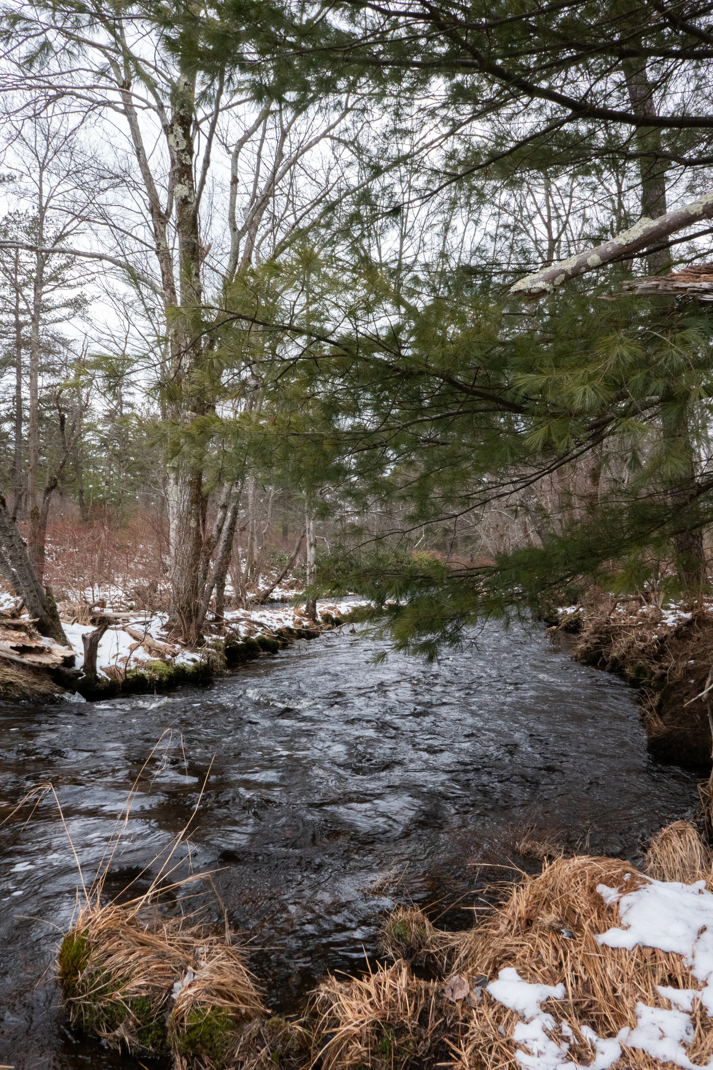
Hiking along the Creekside Trail, I heard the ice crack under the snow. I suspected this would be the case remembering that the last time I visited, much of this trail was very muddy. We had to cross the frozen creek a few times to continue the loop because of the bridges that remained broken.

Nonetheless, the waters of Nescopeck Creek were sparkling in the sunlight and glistening snow. I could hear black-capped chickadee in the trees and the forest was beautiful in all its winter glory.

After crossing a bridge that looked to have been repaired, we got on the Fern Trail to continue the loop. This trail took us away from the creek and into hardwoods. We passed a few cross-country skiers enjoying the day.

We took the Hill Trail to the turtle pond on the eastern side of Lake Frances. We stopped to listen to the quite and enjoy the stillness of the winter day.

Click “Read More” below to see more photos from this hike.

Read More

Bear Creek Preserve, Sparkling Cascades & Mountain Laurel, June 10, 2022

Bear Creek Preserve, Sparkling Cascades & Mountain Laurel, June 10, 2022

Today we did an early morning hike at Bear Creek Preserve. I’m hanging onto what’s left of spring because soon it will be too hot and humid to be out on the trails. The east coast is now transitioning into summer. Personally, I think it’s the worst time of year for hiking. This time of year I wish I was back in SoCal where we could escape to the High Country where the mountains are cooler at elevation. Don’t get me wrong, the trails still got hot, but we knew to be up before dawn and done with our hike by mid-morning. I think I am conditioned from hearing the countless stories of SAR having to rescue people off the mountains because of heat stroke and dehydration. Maybe Pennsylvanians are are a heartier bunch? I’m not really sure. But hiking in heat is not for me. However, back to the hike today… Pennsylvania’s state flower, the mountain laurel, is in full bloom. Clusters of flowers in shades of white and pink adorned the lush, green trails as we meandered along the undulating trail in and out of hardwoods. We started our hike today just off Rabbit Run Lane on the red trail. The trail took us up to the top of the first waterfall and then dipped down to the creek where we picked up the gray trail. The bridge to get across Shades Creek had been blown down by a storm, but it has since been replaced. After crossing the bridge, the trail continued along the creek passing by sparkling cascades and winding in and out of rhododendron tunnels. It took us through a forest of hemlock and white pine and eventually to the spur trail to the bottom of the first waterfall that we’d seen from the top. The last time we were here it was in the winter when we were snowshoeing. Bear Creek Preserve is a beautiful preserve. It has enough variety in scenery so that you don’t get bored since there’s not a whole lot of elevation. We closed the loop at about 6 miles. It was an enjoyable day.

Click “Read More” below for more photos.

Read More

Locust Lake State Park, Locust Creek and Broad Mountain, February 25, 2022

Locust Lake State Park, Locust Creek and Broad Mountain, February 25, 2022

Another cold, icy day. Seems like we’ve had to deal with more ice this year then last year. We headed out to Locust Lake. We’ve had really great weather lately. Mostly blue sky and not the typical winter gray that I remember from last year. We hiked a loop that took us along Locust Creek, up to Broad Mountain then back down. After the hike we stopped to enjoy the icy beach. I’ve never see the beach in the summer and wondered how crowded it gets. Well, no one was here today! So we sat for a while and looked out across the frozen lake watching the ice fisherman before heading home.

Click read more below for more photos.

Read More

Hickory Run State Park, Boulder Field Trail in the Snow, January 30, 2022

Hickory Run State Park,  Boulder Field Trail in the Snow, January 30, 2022

Today we set out much later in the day then expected. Weather was in the teens, but the sky was blue and the snow was fresh . We drove to Hickory Run State Park and decided to check out the trail to Boulder Field. This is about a 7 mile out and back if you start at the trailhead off the 476. The trail was broken for about the first quarter mile, but after that it appeared no one had been on it since the recent snowfall. We continued to make our way winding through a beautiful single track in and out of hemlock, hardwoods and rhododendron. I wish I’d had my snowshoes with me. I underestimated how deep the snow would be. Even so it was still doable with just a little more effort as we broke trail. As the sun started to lower itself in the sky, it cast beautiful hues of orange and long deep shadows on the glistening snow. We thought it would be best to turn around at this point due to the temperatures dropping and because we knew it would soon be getting dark. We made our way back and decided to come back again to complete the trail another day when we have more time and could get an earlier start.

Read More

Delaware Water Gap National Recreation Area, Pocono Environmental Education Center, Tumbling Waters, Ridge Trail, Scenic Gorge Trail, 7 Miles RT, October 22, 2021

Delaware Water Gap National Recreation Area, Pocono Environmental Education Center, Tumbling Waters, Ridge Trail, Scenic Gorge Trail, 7 Miles RT, October 22, 2021

After hiking in the Adirondacks where it was mostly past peak foliage, we were able to catch the some of the colors spreading south through Northeastern Pennsylvania. We hiked the Delaware Water Gap National Recreation Area from the trailhead at the Pocono Environmental Education Center. We first took the Two Ponds trail to Tumbling Waters falls, then back to the parking area where we picked up the Ridge Trail that looped us through Scenic Gorge. Some fun, easy rock scrambles on this hike and pretty scenery made for a nice, relaxing day.

Click on “Read More” below for more photos

Read More

Delaware Water Gap National Recreation Area, Dingmans Falls, Hackers Falls, Cliff Trail, March 4, 2021

Delaware Water Gap National Recreation Area, Dingmans Falls, Hackers Falls, Cliff Trail, March 4, 2021

Today we headed out early to explore the Delaware Water Gap National Recreation Area. Our first stop was Dingmans Falls. This is a popular area with a beautiful boardwalk system that provides safe and easy access leading to two beautiful waterfalls. I was aware that this is a popular destination and can become quite busy, so we arrived just after sunrise. The road to the parking area at the Dingmans Visitor Center was closed (they close it during winter), so we parked in the lot just off the 209 and began a short mile walk down Dingmans Falls Road to the trailhead. The road itself was very scenic as it followed Dingmans Creek past tall pines. As we strolled along I saw a lot of downed trees which I later learned were caused by a violent storm in 2018. Soon we reached the Dingmans Falls Visitor Center where the smooth boardwalk trail begins. It crossed over Dingmans Creek and within just a short distance we were treated to a view of our first waterfall of the day, the 80 foot Silver Thread Falls. Silver Thread is tall, narrow and drops over the rocky cliffs in almost a perfectly straight line; hence the name “silver thread”. As we continued on the boardwalk we passed through large stands of rhododendron surrounding us on either side. It gave the trail a jungle-like feeling. In less than a mile we arrived at the majestic 130 foot Dingmans Falls. This waterfall is noted as being the second tallest in Pennsylvania; the tallest is Raymondskill Falls just a few miles up the road. The fast flowing waters tumbled down a gorge carved into exposed bedrock from the Devonian period 365-405 million years ago. We spent some time taking photos and enjoying the views before making our way up a steep wooden staircase to the top of the falls. The views from above were just as spectacular as below as the water spilled down the 130 foot vertical drop. After taking in the scenery and making sure to grab lots of photos, we decided it was time to start heading back so we could enjoy another trail while it was still early. We walked back to the parking area, hopped in the car and headed north on the 209 to the Hackers trailhead on Raymondskill Road where we planned to hike to Hackers Falls and the Cliff Trail. The Hackers trail began on a gravel path leading uphill. As it leveled off we were taken on a pleasant walk through an inviting hemlock forest. We then reached the junction for the waterfall and descended steeply. As we continued to follow the trail, I could hear Raymondskill Creek off in the distance. Soon we were hiking above and parallel to the creek. Within about a mile we reached Hackers Falls. This waterfall was steep but short and shaped like a feather fan. We spent some time taking photos, studying the rocks and enjoying the small but mighty waterfall before making a gentle ascent back up the Hackers trail through more hemlocks and mixed hardwoods. Next, we reached a junction for the Buchanan trail which ran north along a power line. We passed by an abandoned building and a dilapidated trailer home just before reaching a pond. When we arrived at the junction for the Cliff Trail, it was closed due to nesting Peregrine Falcons. We backtracked onto the Hackers Trail to access the Cliff Trail from the opposite direction. This section was open so we followed the trail to the first vista. From here I could see the Delaware River and across to New Jersey. We continued along the Cliff Trail as it travelled along the Raymondskill Ridge offering sweeping views along the way. Several vultures soared at eye-level as we hiked. It was a beautiful sunny day and by the time we reached the parking area, it was already full with people coming out to enjoy this perfect spring day.

Click on “Read More” below for more photos.

Read More

Hiking Chestnut Mountain Nature Preserve, April 3, 2021

Hiking Chestnut Mountain Nature Preserve, April 3, 2021

Today we explored the Chestnut Mountain Nature Preserve in Barrett Township. This area was going to be developed and town homes built on the land, but plans failed and the new owner timbered the forest. Buck Hill Conservation Foundation acquired the land and opened the preserve to the public in 2012. This was an interesting hike exploring a forest in recovery. We hiked along rugged logging roads and challenging terrain rutted with deep holes hidden beneath leaves and between large rocks where trees that once stood were pulled up from their roots. Much of the trail is undefined, but there are helpful blue and red markers to guide you along the way. We began the hike from a small parking area just off the 191. The morning was chilly; only 27 degrees. There was a layer of thin ice on top of the frozen leaves that covered the logging road which begins the hike. Right away I noticed the sparseness of the forest. Along the trail we spotted a beech tree that had bear claw marks in its bark. The logging road dipped slightly downhill and after about a mile made its way up a magical, mossy green carpet to an overlook. The area here was flat, wide and scattered with trees, stumps and boulders. From this vantage point I could see Mt. Wismer and High Knob. We explored the area despite the wind which made it feel even colder than it was for a spring morning. We then continued along the trail and made a descent onto a path much less defined. We followed the helpful blue markers until we reached a junction for the red trail. Here, we checked our map and decided to follow it since it would add some extra mileage to our day. We passed by even more boulders of various shapes and sizes. I saw a fallen log covered in velvety bluish-gray mushrooms. I haven’t studied up on mushroom identification yet, so I guess I’ll need to do that now since Pennsylvania sure has a lot of them. Soon, the trail began to traverse uphill where we crossed over a small stream flowing down from the mountain. The vegetation here was thick and overgrown. We bushwhacked our way through and the terrain became even more challenging with rocks and deep ruts hidden by leaf debris. We crossed over large, fallen trees being careful of each step. I noticed piles of chipped wood scattered around tree roots. As I looked up, I could see large, deep holes pecked into the tree’s trunk; the work of persistent woodpeckers. I also took note of some sapling hemlock trees peeking out from under the leaves; a promise that one day this would again be a healthy forest. Eventually, the trail made its way back to another logging road which was much easier to walk on. The day was warming up and with the workout we were getting, I was starting to work up a sweat. I took a moment to set down my pack and remove a layer, and as I glanced at the trail up ahead I saw a huge black bear! The big bear was sauntering across the trail and appeared to be foraging for food. We watched for a moment before my husband blew the safety whistle to make the bear aware of our presence. The bear then took off into the woods. We waited a moment to give the bear some leeway before continuing up the trail. It was a very exciting moment and my first time seeing a bear in Pennsylvania. The trail continued to make its way uphill and finally back to the trailhead. It was a wonderful day and an interesting trail full of fun challenges, surprises and promise.

Click on “Read More” below for more photos.

Read More

Day Hike at the Van Buskirk Farm Preserve, March 27, 2021

Day Hike at the Van Buskirk Farm Preserve, March 27, 2021

Today our hike took place at the Van Buskirk Farm Preserve in the Pocono Mountains. We parked at the trailhead on the east side of Cranberry Creek and headed out onto the trail. Immediately, we were transported into an ethereal world of towering hemlocks, a roaring creek and huge boulders carpeted in thick green moss. It was beautiful here. And only a few steps away from the road. I wondered how many people drive by this place every day and don’t even notice the inconspicuous trail and the beauty that lies just beyond. We took time to explore the area and capture the morning sunlight that shone through the pines and sparkled on the clear waters of the creek. We crossed over a primitive wooden bridge to the other side where we found large trees taller than a building toppled over from a powerful windstorm. I can’t even imagine the force it must have taken to uproot them. Next we continued along the trail which paralleled the creek crossing over patches of mud, rocks and small streams flowing down from the mountain. The trail then turned west and made an ascent towards more downed trees that we had to to navigate around. As the trail leveled out we were treated to a path of soft pine needles that always feel so good on your feet after traversing rocky terrain. We passed through the middle of an old stone wall, left from days gone by. As we hiked along the wind whispered through the trees and gently moved cumulus clouds across the sky like soft puffs of white cotton. We made our way through more patches of mud and wet leaves before the trail became a pleasant mossy path passing through rows of young white pine. Soon we found ourselves at an open meadow and before us stood the ruins of an early 20th century farm. We observed some old farm equipment and the remnants of a stone structure. Below the ruins was an open field which I imagined may once have been an orchard abundant with fruit trees. After exploring the farm, we continued on our way. Next, the trail led us to an open area at the foot of a rock quarry surrounded by vernal pools. A chorus of wood frogs filled our ears. These pools must have been loaded with them. We made our way up to the top of the quarry where twisted pitch pines grew out from its rocky ledges. We took in the view and enjoyed the mountain breeze before heading back down to the trail. Soon we were back at the beginning of the loop that would take us back the way we came along the creek. By this time it was early afternoon and with the beautiful weather, we decided to sit aside the creek and enjoy a snack before heading back home.

Click on “Read More” below for more photos.

Read More

Exploring Paradise Price Preserve and Targa Falls on the Brodhead Creek, March 21, 2021

Exploring Paradise Price Preserve and Targa Falls on the Brodhead Creek, March 21, 2021

It was a glorious Sunday morning. The air was crisp and the sun was gleaming in hues of orange and gold as we set out on the loop trail to hike to Targa Falls from the western side of Paradise Price Preserve. The trail started out in a forest of hardwoods scattered with eastern white pine. As we walked along the wide, rocky path heading east into the bright morning sunlight, the song of an eastern bluebird filled the air. We passed by vernal pools, wetlands and observed various types of fungi attached to fallen logs. Soon we came upon a picnic table along the side of the trail. We sat for a moment to enjoy the quiet of the peaceful forest. When we were ready, we continued along the path which was now starting a descent towards the Brodhead Creek. We passed by large boulders and crossed over tributaries that were flowing down from the ridge. We then turned onto the spur trail that took us directly to the large horseshoe shaped Targa Falls. This is the only natural waterfall on the Brodhead Creek. It’s not a tall waterfall, but its waters roar and move swiftly. We climbed down to the falls where I sat on some large boulder slabs to take in the scenery as the creek crashed and roared downstream. A cool mist from the falls brushed against my face. It felt so refreshing in the warm sunshine. I dipped my hand in to feel the cold, sparkling water. It was a lovely place to sit for a while, enjoy a snack and take in the beauty of nature before continuing. Once back on the loop, the trail took us above the Brodhead offering us lovely views of the rapids along the way before turning west and taking us back in the direction of the trailhead. It was a gorgeous day and the more time I spend hiking the trails here in northeastern Pennsylvania, the more the landscape is starting to grow on me. I’m finding so many gems right here in the Pocono Mountains, and I can’t wait to continue exploring all that this area and beyond has to offer.

Click on “Read More” below for more photos.

Read More

Sunrise on Mt. Wismer and an afternoon at Stony Run in the Delaware State Forest, Vernal Equinox, March 20, 2021

Sunrise on Mt. Wismer and an afternoon at Stony Run in the Delaware State Forest, Vernal Equinox, March 20, 2021

Today was the vernal equinox, a time when day and night are in equal balance. To honor the official beginning of spring, we set out for a sunrise hike to the top of Mt. Wismer in Monroe County. We parked at the trailhead just off the 447 to take the blue blazed trail. This is actually the easy route. There’s a more challenging hike from the trailhead off Gravel Road. Today we were interested in doing photography and catching the light of the sunrise. It was a crisp, cold morning and as the sun began to rise up over the mountain, we made our way down a wide open path which led to the blue blazed trail. The trail heading up had patches of hard snow and ice. As we hiked along the trail became a single track and I noticed large moss covered boulders above us dripping with melting ice. Spring surely is here. The trail was rocky and wet with leaves as it gently ascended through large rhododendrons and hemlock trees. We followed along the escarpment of the mountain, and as it curved to the east we were almost blinded by the blazing sun coming up over the horizon. At the top we were rewarded with wide open views. From here we could see Gravel Pond, Camelback Mountain and even more impressive, the obvious gap of the Delaware Water Gap. The light was absolutely brilliant. We meandered around the overlook enjoying the open landscape before heading north on an unmarked trail. We hiked along the path through hardwoods, and then found ourselves in a beautiful grove of hemlock. The sunshine shimmered through the towering trees, and I heard the call of a tufted titmouse. Soon we were at the close of the loop and back at the trailhead. It was still very early and neither of us were ready to head home, so we opted to take another hike. We decided to venture into the Delaware State Forest to Stony Run. We parked the car at an unmarked trailhead off Snow Hill Road and headed onto a wide grassy trail. The trail began to descend southward and became more rocky. As we hiked I spotted two white-tailed deer off in the distance who quickly disappeared into the woods. Soon the trees began to thicken with evergreens and I could hear the sound of fast moving water. A wooden bridge came into view and we were now at Stony Run. From the bridge I watched the run as it tumbled and danced over moss-covered rocks. We explored the area for a bit then found a comfy spot to settle in, have a snack and enjoy the scenery. After our little break, we started to make our way to the trailhead. We took a short off-trail adventure over to a large rock outcropping with some nice views. Three large black vultures sored high above us in the sky. By now the day had warmed up to about 55 degrees, but it was time to make our way back and head home. It was a beautiful way to kick off the first day of spring.

Click on “Read More” below for more photos.

Read More

Nothstein Preserve, Exploring Cranberry Creek and Red Rock Quarry, March 14, 2021

Nothstein Preserve, Exploring Cranberry Creek and Red Rock Quarry, March 14, 2021

I’m finding some really great nature preserves here in the Keystone state. This past Saturday we ventured off to explore the Nothstein Preserve located in Paradise Township in Monroe County. The hike took us through a variety of different terrain, along the ravine of Cranberry Creek and up to a red rock quarry with views extending from east to west across the ridge to the surrounding preserves. We started at the trailhead off Cranberry Creek Road and headed north on a wide path in a counter clockwise direction. The forest was mostly hardwood dappled with tall hemlock trees. Immediately my ears were filled with the pleasant harmony of morning birdsong. We passed by marshes, bogs and small tributaries until we reached a primitive bridge crossing over the pristine waters of Cranberry Creek. We took a moment to branch off and explore its banks and the surrounding feeder creeks before continuing on a single track where we began to ascend gently upward. The trail reached an intersection where we turned northwest. I spotted some train tracks above us running parallel to our path. We made several primitive creek crossings over the crystal clear waters flowing down the mountain and over thick, bright green moss. Now the trail began to descend southwest. The forest became dense with hemlock, and I could hear the sound of rushing water flowing just beyond the trees. The path opened up to reveal another bridge crossing over the fast moving Cranberry Creek. Lined with rhododendron just beyond the bridge, the terrain became a snow covered single track leading us upward above the ravine. We made our way up the trail being careful on the icy patches of snow until reaching a vista of the beautiful cascading waters below. I made sure to get some photos from above, but I wanted to take a closer look. We then backtracked and made our way to a section of trail following along the edge creek where we could enjoy a closer perspective of the sights and sounds of the waterfalls and tumbling cascades. Eventually, we backtracked crossing over the bridge once again and up through the hard packed snow back to the top of the ravine. Soon, the trail began to move away from the creek and the forest became even more dense with tall stands of hemlock and oak. We crossed over more small tributaries being careful not to slip on the moss covered rocks. I’m not sure if it was the tall stands of pine or the way the sunlight was shining through, but this section of trail reminded me a little bit of my beloved Angeles National Forest. It was another lovely section of trail. The path widened again and took us under a canopy of pine. The trail became a bed of soft pine needles beneath our feet. As we travelled up the slope we were led to an old stone red rock quarry. Two large ravens suddenly emerged from the trees and soared across the blue sky above. Again, I felt at home as I was reminded of my life in California where there were always ravens to accompany me along my hikes in the higher elevations. As we traversed along the edge of the quarry, we were treated with sweeping views across the gorge and the ridge beyond. I was awe struck at how a place so beautiful can be so close to civilization. We spent some time exploring around the quarry before moving on, back into the hardwoods and finally looping back down to the woodland path on which we started. It was an absolutely amazing day and a beautiful preserve full of wild, natural beauty to explore and admire.

Click on “Read More” below for more photos.

Read More

Hickory Run State Park, Hawk Falls, Orchard Trail, Mud Run, March 6, 2021

Hickory Run State Park, Hawk Falls, Orchard Trail, Mud Run, March 6, 2021

Today our adventures took us to Hickory Run State Park. The last time we were here it was fall when the leaves were showing off their vibrant autumn colors. I was excited to see how it was going to look in winter covered in snow. We got an early start so we could avoid the crowds. This area has become quite popular over the years, and can be very overcrowded on weekends. The parking area for Hawk Falls off route 534 was empty when we arrived. We parked the car, geared up in our microspikes and made our way onto the icy trail. Light snow showers began just as we started the hike. The trail was packed down into a hard sheet of ice. But the path was wide and not very steep, so it was safe to travel with just light traction. A foot bridge crossed over Hawk Run, and we continued past steep rock walls lined in hemlock and rhododendron. We followed a short use trail to a rock outcropping that gave us a nice view of the top of the falls tumbling down the side of the rocky ledge. It looked so beautiful as soft white snowflakes fell from the sky. In just a short .6 miles we arrived at the bottom where the 25 foot Hawk Falls plunged into a clear pool of cascades. We spent some time here enjoying the magnificence of this natural waterfall. Near the falls, we noticed some ice formations along the high cliff walls and decided to explore them. The moss covered ledges and large icicles dripped with melting water. We then got back on the trail and followed along Mud Run until we reached the junction for the Orchard Trail. We turned east and made an ascent up a hill and onto a ridge with nice views that continued through a hardwood forest. Eventually, the trail dropped us down again on some switchbacks into a windy thicket of rhododendron. It led us to a large rock outcrop just above Mud Run where spectacular cascades tumbled over large rocks and boulders. There were many use trails branching off to offer closer views of the beautiful water flow. The trail then turned northeast and we started to ascend moving away from the creek. Now higher above Mud Run the trail was a mix of patchy snow and muddy pools of water flowing down the mountain. Our waterproof boots came in handy here. Eventually, the trail looped west and back into the hardwoods where it was mostly snow. We closed the lollipop loop and made our way back over the ridge and down to the Hawk Falls trail to return the way we came. By this time many people were starting to arrive. We saw several large groups slipping and sliding on the ice attempting to make their way to the falls on the icy trail. When we arrived back at the parking area, there were at least 20+ cars with more lining up to get a spot. I was grateful to have been able to enjoy a quiet morning in solitude along this beautiful trail.

Click on “Read More” below for more photos.

Read More

Bear Creek Preserve Snowshoeing, 6 Miles RT, February 21, 2021

Bear Creek Preserve Snowshoeing, 6 Miles RT, February 21, 2021

February of 2021 brought the Lehigh Valley 38.8 inches of snow, the highest amount for the month to date. The days have been dark and gloomy, but today the sun made a glorious appearance. It was bound to be an amazing day, so we gathered our gear and headed out on the road into the Pocono Mountains. Our destination was Natural Lands Bear Creek Preserve. The early morning temperature was 19 degrees and the parking turnout at the trailhead off White Haven Road was still frozen. We suited up and hit the trail. We started out by following the purple trail south which took us through a hardwood forest scattered with mountain laurel and moss covered boulder formations. The beech trees still holding onto their autumn leaves glistened with a warm orange hue. We passed by a ravine with a waterfall now frozen into a striking 10 foot flow of ice. Sunlight danced on the frosty boughs of hemlock that still hung heavy with snow. As we meandered along the winding trail we began to descend closer to Shades Creek. We then connected to the gray trail as we reached the swinging bridge and crossed over the rapids. The winter landscape looked so amazing as we followed along the snow covered banks. We made our way in and out of rhododendron tunnels stopping every few feet to admire the fast flowing cascades. Sparkles of snow glistened in the sunlight as they fell from the trees like fairy dust. Before we knew it it was already getting to be late afternoon. As much as we wanted to stay, we knew we should start heading back. When we reconnected with the purple trail, we decided to make a quick side trip and follow it south. It crossed over Bear Creek on a primitive bridge and from here we went off trail to continue a little further along its edge. It was a beautiful section of trail, but we didn’t go too far since it was too late in the day to explore. We turned around making note to save that adventure for another time. We ascended steeply back up the hill, back into the hardwood forest and past the frozen waterfall. By this time, the sun had shifted lower on the horizon illuminating the landscape with its radiant afternoon light. When we arrived back at the trailhead, the frozen parking lot was a swimming pool of melted ice. We loaded up the car and headed home after another amazing winter’s day.

Click on “Read More” below for more photos.

Read More

Delaware State Forest, Egypt Meadow Lake, Snowshoeing, February 14, 2021

Delaware State Forest, Egypt Meadow Lake, Snowshoeing, February 14, 2021

Today we ventured out again to take advantage of the abundant snowfall in the Pocono Mountains. This time our destination was the Delaware State Forest. We parked at the trailhead for Egypt Meadow Lake off Route 390 just north of Promised Land State Park. From here we donned our snowshoes and headed out into a winter wonderland. The snow was even deeper than what we had experienced yesterday at Nescopeck State Park. But it was light and powdery and such a delight to walk on. We traveled east along a wide path through a hardwood forest. Soon enough Egypt Meadow Lake came into view. Egypt Meadow Lake was built by the Civilian Conservation Corps in 1935. It’s one of the few undeveloped lakes in Pennsylvania that can only be accessed by hiking. Today it was a sheet of solid ice covered in a veil of pure white snow. As we followed along the main path we came upon a side trail that looked like it would take us in for a closer look. We decided to explore. As we approached the icy shores we saw tracks made by humans leading out across the frozen lake. Ice thickness needs to be at least 4 inches to support the weight of a person up to 200 lbs. It appeared solid enough, so we made our way out onto the lake slowly and carefully. As we ventured further towards the center, expansive views opened up in all directions. It was such a thrill to be standing out there on top of the frozen water and enjoying the lake from this perspective. After taking it all in, we made our way back to the trail and continued following across the outlet of the dam. We then began to ascend on a single track into an exquisite forest of pine. The snowy path undulated gently along the shores of Egypt Meadow Lake and meandered in and out of giant hemlock trees. We passed by rhododendron, mountain laurels and rock formations that were almost hidden by the deep drifts of snow. It was an absolutely beautiful trail. At about 2 miles we came to the bridge that would cross over Egypt Meadow Lake and begin the second half of the loop around its western shores. This section of trail was equally as beautiful as the first half of the loop. We took our time as we snowshoed atop the magical white blanket covering the earth enjoying the beauty of the forest on this incredible winter day.

Click on “Read More” below for more photos.

Read More

Enjoying Conifers and Glacial Wetlands at the Thomas Darling Preserve, 2.5 Mile Walk, January 18, 2021

Enjoying Conifers and Glacial Wetlands at the Thomas Darling Preserve, 2.5 Mile Walk, January 18, 2021

We were back at it again today exploring another nature preserve. This time we drove back to the Pocono Mountains. There are so many great places to see in this area that aren’t too far off the 115. The Thomas Darling Preserve is another preserve that’s part of the Wildlands Conservancy Land Trust. It was named after conservationist Thomas Darling Jr. This area has one of Pennsylvania’s largest spruce forests, and boy was I excited about that! I love me some conifers! The preserve is made up of 2,500 acres with glacial wetlands, meadows, bogs, and forest. Two Mile Run traverses the preserve before spilling into Tobyhanna Creek. The hike around the preserve is a short 2.5 mile loop, but it really packs in the scenery! After leaving the trailhead just off Burger Road/T551, the trail takes you along a boardwalk and through the wetlands. You are then transported into a beautiful evergreen forest. It was about 30 degrees in the morning today and being we were walking through wetlands, the trail was icy under the light dusting of snow that was covering the ground. I couldn’t get over how pretty it was walking through the snow covered conifers. At about .7 miles we reached Two Mile Run. We took a moment here to enjoy the beauty of the cascading pools. Next we headed on a long section of boardwalk that traversed an expansive wet meadow. There were more evergreens and also birch trees with their white bark. I’m not sure which part of the trail was my favorite, this section or the spruce forest. The boardwalk going through the meadow made us feel like we were transported into some other land… and really, if you think about it, we were. After this section of trail we headed into a hardwood forest and it began to flurry with some light snow. It was such a beautiful scene. As we arrived back at the trailhead, the snow flurries picked up and we were soon on our way headed out for a hot cup of coffee after a really wonderful day.

Click on “Read More” below for more photos.

Read More

Wildlands Conservancy Maple Tract Preserve, 6 Miles RT, January 17, 2021

Wildlands Conservancy Maple Tract Preserve, 6 Miles RT, January 17, 2021

Pennsylvania has a good number of nature preserves to explore. Today we headed back up to the Pocono Mountains to the Maple Tract Preserve located near the 115 in Long Pond. The preserve is part of the Wildlands Conservancy Land Trust, and there are about 8 miles of hiking trails within its 680 acres. The area is made up of glacial wetlands, forest, mountain laurel and rhododendron which is so commonly found along the creekside trails of Pennsylvania. We started on the red trail heading southwest which took us past a frozen pond and along a carpet of soft pine needles. The day was mostly cloudy, which I’m learning is pretty typical of a Pennsylvania winter. As we continued we came up on another frozen pond. It seemed pretty solid so I got brave and ventured out onto it. It’s been years since I stood on a natural, frozen body of water. I remember ice skating on them as a kid many moons ago. We then continued along the trail through more forest of hemlock, spruce, larch, rhododendron and mountain laurel. I’m finally starting to be able to identify some of the trees and plants here on the east coast. It’s still very foreign to me since being out west all these years. As we hiked, we came upon some sections of trail that were on boardwalks to get across the wet marshes that were mostly frozen over. At about 2.5 miles we found Tunkhannock Creek. We walked down to the banks to get a better view and take some pictures. From here we followed the red trail west a bit further to enjoy more views of the creek before backtracking and heading north to explore the blue trail. I was really impressed with the scenery at this preserve. I loved the hilly ups and downs of the trail and the varying terrain. We hiked about 6 miles and didn’t see another person the entire day. This preserve is located close to the 80 and also the Pocono Raceway. I would imagine it might get a little noisy in the summer when the raceway is open. Nonetheless it is an incredibly beautiful area to explore.

Click Read More Below for More Photos

Read More

Winter Hiking Around Bear Creek Preserve, 6 Miles RT from White Haven Rd., January 10, 2021

Winter Hiking Around Bear Creek Preserve, 6 Miles RT from White Haven Rd., January 10, 2021

We had a perfect day of winter hiking around Bear Creek Preserve. This time we accessed the trail from White Haven Road on the west side of the preserve. It was a chilly morning (somewhere in the low 20s), but we warmed up as soon as we got moving. The lighting today was lovely. My husband had just gotten a GoPro camera, and he wanted to test it out. I couldn’t think of a better place to be on this fine winter morning. We started the hike following the purple trail which met up with the red trail and then the gray trail. This would take us right to swinging bridge and the beautiful waterfalls and cascades of Shades Creek. Before we arrived at the swinging bridge, we hiked along a path at the top of a beautiful frozen 10 foot waterfall I stopped here for a moment to enjoy the scenery before continuing along the trail. We spent most of the day experimenting with cameras and video, but we ended up hiking about 6 miles before returning home. Some day when we aren’t on a camera test mission, I’d like to hike the whole purple trail loop. It was such an amazing day. Both of us got a lot of great pictures and video.

Click on Read More Below for More Photos from this Hike.

Read More

New Year's Day Hike, Austin T. Blakeslee Natural Area, January 1, 2021

New Year's Day Hike, Austin T. Blakeslee Natural Area, January 1, 2021

We started out the year with a hike to Tobyhanna Falls in the Austin T. Blakeslee Natural Area. Pennsylvania has so many waterfalls, I haven’t even scratched the surface of what there is to discover. The weather reports were calling for freezing rain later in the day, so we got up and out early so as not to risk it.

The Austin T. Blakeslee Natural Area was once home to Harrison Amusement Park which entertained the community along the Tobyhanna Creek. What was then known as Toby Park had a carousel, skating rink, swimming pool, dining hall, penny arcade, sporting fields and a creekside beach. It was destroyed in a flood in 1955.

Today the area is open to hikers with a small network of trails that take the hiker along Tobyhanna Creek to the scenic Tobyhanna Falls.

We started at the trailhead off the 115 heading west along the Creek Trail. The first section of the hike takes you through a beautiful stand of tall spruce trees. A short half a mile walk then leads to the waterfall. The falls aren’t very tall, but they are mighty. It’s quite a spectacle to see. The fast moving water was tinted with an amber color which is caused by the tannic acid produced by hemlock and spruce along the banks of the creek. It was a beautiful site to start off the new year. After taking it all in, we continued west. At about .9 miles Tunkhannock Creek flows into Tobyhanna. We looped around north heading away from the creek on the Highland Trail and into a beautiful coniferous forest.

It was a wonderful morning and this is a beautiful area to explore in just a few short miles. We got back in plenty of time to beat the weather.

(Click Read More Below to See More Photos)

Read More

Bear Creek Preserve, Red Trail, Gray Trail, Red/Green Trail, 7 miles RT, December 13, 2020

Bear Creek Preserve, Red Trail, Gray Trail, Red/Green Trail, 7 miles RT, December 13, 2020

Beautiful creekside hiking at Bear Creek Preserve this weekend! This has been my favorite hike in NEPA thus far. We started from the trailhead at Rabbit Run Lane on the red trail and connected to the gray tail heading south along Shades Creek. This section of trail was just beautiful with many cascades flowing into deep, clear pools, waterfalls and undulating trail through rhododendron jungles, in and out of hemlock forest and mossy wetland. Before reconnecting to the red trail and heading back north, we crossed over Shades Creek on a really cool suspension bridge. The terrain for most of this hike was rocky and slippery with wet leaves, but I'm getting used to my feet taking a beating on these east coast trails and learning to slow down a bit and take my time. East coast hiking is very different from out west. There may not be much elevation to gain, but I’m starting to find some locations that feel a little more remote where we can track some decent mileage. We followed the red trail back to the trailhead and closed the loop at about 7 miles RT. Absolutely beautiful place to explore.

Read More