The first stop on our Sunday adventure was Targa Falls, a natural waterfall found on the Broadhead Creek. The waterfall is easily accessible from a parking area just off the 447, or you can hike to it from the Paradise Price Preserve. I wanted to see and photograph it in the very early morning sunshine, so we chose the easy drive up access for today. Someday I plan to return to hike in from the west side of the preserve. We parked the car and as I stepped out I could hear the loud rushing waters. Just a few steps more and there it was, this incredible flowing creek roaring past me over large, rocky boulders. The early morning sunlight danced on the white foaming rapids, and the tall hemlocks swayed in the breeze on the banks. It was a beautiful sight just a stone’s throw away from the road. At that moment I honestly felt a little guilty having such a natural wonder within such easy reach. Being used to the rugged mountains of Southern California, I’m not used to having this kind of quick and easy access to something so beautiful as a roaring waterfall. I got my hiking legs out west where you have to earn your views by trekking miles into the wilderness and climbing to precarious mountain tops to view such spectacular places; no cell service, no wifi and only your two legs to rely on to get you there and back. Pennsylvanian’s are so very lucky in this respect.
After enjoying the waterfalls, we hopped back in the car and headed to the trailhead for the Red Rock Loop and Mt. Sophia. The Red Rock Trail is part of the Mount Airy Trail Network and sits on lands protected by a conservation easement held by Paradise Township. At the trailhead there’s a helpful map laying out the topography of the hike, and the trail begins just beyond the kiosk. It starts out on a gravel path leading up stone steps. Right away I noticed the beautiful oak trees and not far into the trail we arrived at a vernal pool. I imagined it would soon be filled with salamanders, wood frogs and other critters. The trails here seemed to be very well kept (save for some downed trees), and they were so pleasant to walk on. So much so that I forgot how rocky the Pennsylvania terrain usually is. We soon arrived at a well-marked junction for the Red Rock Loop and decided to continue northwest directly towards the junction for the top of Mt. Sophia. Along the trail there were large stands of mountain laurel which I am so excited to see bloom in late spring and early summer. This will be my first spring on the east coast in over 20 years. Soon the trail became covered with patches of icy snow and we reached the junction for Mt. Sophia. The trail took us up gently graded switchbacks and as we continued upward, there were helpful wooden steps peeking out from underneath the snow. As we approached the summit, an impressive forest of large pine and hemlock came into view. The sunlight radiated through the majestic trees. I spent some time exploring the summit and the views. From here I could make out the ski runs on Camelback Mountain to the south and more views to the north. We followed the trail a little further as it looped us around in a circle with a convenient “Exit” sign pointing back to the direction in which we came. We took our time hiking down enjoying the views through the beautiful pines and the sunshine. We then arrived at a junction for Red Rock Spur #1. It led us to the site of an old car from the 50s that was flipped upside down and settled into a ditch. It made me wonder what its story was and how it even got up there. There were some old logs that looked like they’d make a perfect place to sit down and enjoy the fresh mountain air, so we sat down and took a break. It was a windy day and I was enjoying listening to that groaning, creaky sound the trees make when they sway against each other in the wind. After our break, we continued along the trail and the winds started kicking up even more. We reached a junction for Red Rock Spur #2 (another outer loop) and began a gentle ascent. We passed by some interesting rock formations before noticing a vintage car graveyard nestled below us, deep in the woods. Had this been summer, we would have never even seen it since the trees would have concealed it with their leaves. We decided to move in closer to explore. There were three rusty cars who had clearly been here for a long time; their final resting place nestled into the forest. We took some photos and then got back on route, enjoying more views to the south as we hiked. The trail made its way down some lovely switchbacks until finally we were back at the junction for the Red Rock Trail on which we had started. This was a wonderful day hike. I really enjoyed my time here and again, it felt like wilderness even though we were so close to civilization. I’d like to come back again and explore more of the spurs and see it when the mountain laurel is in full bloom.
Today our adventures took us to Hickory Run State Park. The last time we were here it was fall when the leaves were showing off their vibrant autumn colors. I was excited to see how it was going to look in winter covered in snow. We got an early start so we could avoid the crowds. This area has become quite popular over the years, and can be very overcrowded on weekends. The parking area for Hawk Falls off route 534 was empty when we arrived. We parked the car, geared up in our microspikes and made our way onto the icy trail. Light snow showers began just as we started the hike. The trail was packed down into a hard sheet of ice. But the path was wide and not very steep, so it was safe to travel with just light traction. A foot bridge crossed over Hawk Run, and we continued past steep rock walls lined in hemlock and rhododendron. We followed a short use trail to a rock outcropping that gave us a nice view of the top of the falls tumbling down the side of the rocky ledge. It looked so beautiful as soft white snowflakes fell from the sky. In just a short .6 miles we arrived at the bottom where the 25 foot Hawk Falls plunged into a clear pool of cascades. We spent some time here enjoying the magnificence of this natural waterfall. Near the falls, we noticed some ice formations along the high cliff walls and decided to explore them. The moss covered ledges and large icicles dripped with melting water. We then got back on the trail and followed along Mud Run until we reached the junction for the Orchard Trail. We turned east and made an ascent up a hill and onto a ridge with nice views that continued through a hardwood forest. Eventually, the trail dropped us down again on some switchbacks into a windy thicket of rhododendron. It led us to a large rock outcrop just above Mud Run where spectacular cascades tumbled over large rocks and boulders. There were many use trails branching off to offer closer views of the beautiful water flow. The trail then turned northeast and we started to ascend moving away from the creek. Now higher above Mud Run the trail was a mix of patchy snow and muddy pools of water flowing down the mountain. Our waterproof boots came in handy here. Eventually, the trail looped west and back into the hardwoods where it was mostly snow. We closed the lollipop loop and made our way back over the ridge and down to the Hawk Falls trail to return the way we came. By this time many people were starting to arrive. We saw several large groups slipping and sliding on the ice attempting to make their way to the falls on the icy trail. When we arrived back at the parking area, there were at least 20+ cars with more lining up to get a spot. I was grateful to have been able to enjoy a quiet morning in solitude along this beautiful trail.
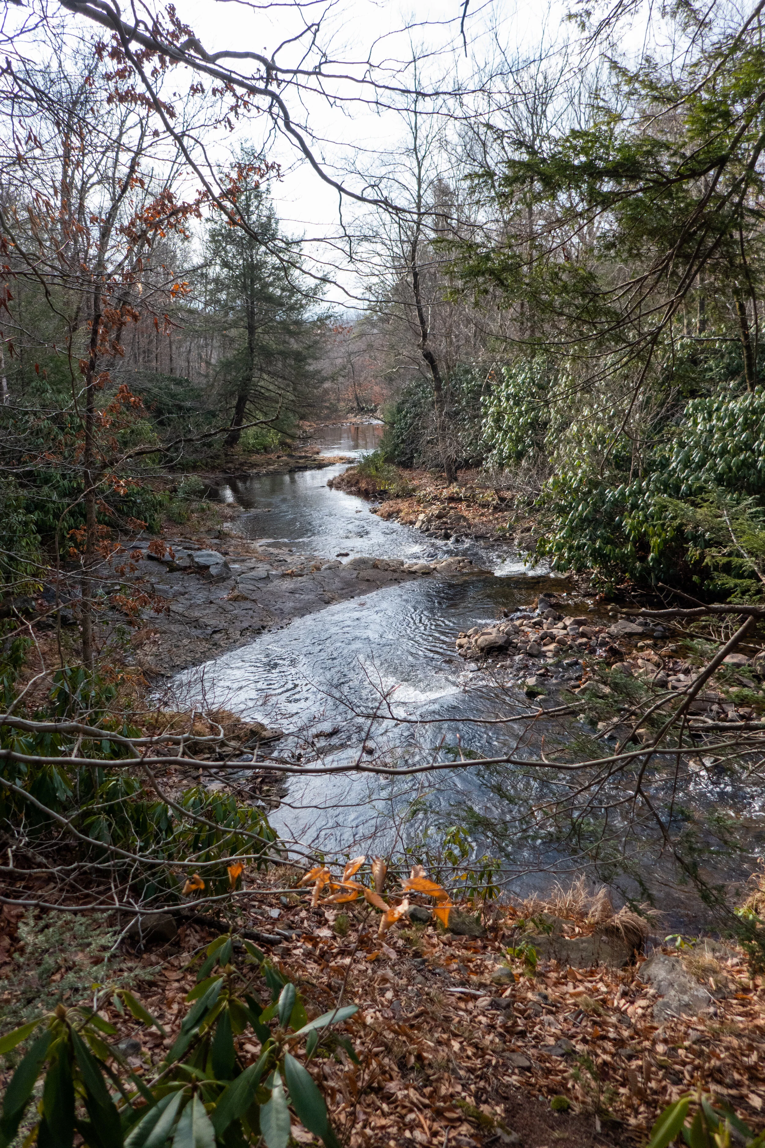
We started out the year with a hike to Tobyhanna Falls in the Austin T. Blakeslee Natural Area. Pennsylvania has so many waterfalls, I haven’t even scratched the surface of what there is to discover. The weather reports were calling for freezing rain later in the day, so we got up and out early so as not to risk it.
The Austin T. Blakeslee Natural Area was once home to Harrison Amusement Park which entertained the community along the Tobyhanna Creek. What was then known as Toby Park had a carousel, skating rink, swimming pool, dining hall, penny arcade, sporting fields and a creekside beach. It was destroyed in a flood in 1955.
Today the area is open to hikers with a small network of trails that take the hiker along Tobyhanna Creek to the scenic Tobyhanna Falls.
We started at the trailhead off the 115 heading west along the Creek Trail. The first section of the hike takes you through a beautiful stand of tall spruce trees. A short half a mile walk then leads to the waterfall. The falls aren’t very tall, but they are mighty. It’s quite a spectacle to see. The fast moving water was tinted with an amber color which is caused by the tannic acid produced by hemlock and spruce along the banks of the creek. It was a beautiful site to start off the new year. After taking it all in, we continued west. At about .9 miles Tunkhannock Creek flows into Tobyhanna. We looped around north heading away from the creek on the Highland Trail and into a beautiful coniferous forest.
It was a wonderful morning and this is a beautiful area to explore in just a few short miles. We got back in plenty of time to beat the weather.
Beautiful creekside hiking at Bear Creek Preserve this weekend! This has been my favorite hike in NEPA thus far. We started from the trailhead at Rabbit Run Lane on the red trail and connected to the gray tail heading south along Shades Creek. This section of trail was just beautiful with many cascades flowing into deep, clear pools, waterfalls and undulating trail through rhododendron jungles, in and out of hemlock forest and mossy wetland. Before reconnecting to the red trail and heading back north, we crossed over Shades Creek on a really cool suspension bridge. The terrain for most of this hike was rocky and slippery with wet leaves, but I'm getting used to my feet taking a beating on these east coast trails and learning to slow down a bit and take my time. East coast hiking is very different from out west. There may not be much elevation to gain, but I’m starting to find some locations that feel a little more remote where we can track some decent mileage. We followed the red trail back to the trailhead and closed the loop at about 7 miles RT. Absolutely beautiful place to explore.
The colors are really starting to show in Pennsylvania. Today I went to Jacobsburg State Park and walked from Henrys Woods over to the the National Historic District Site to check out the Henry Homestead/PA Longrifle Museum. I also took some time today to check out the birding area across Belfast Road near Henrys Forge. I didn’t have my birding camera with me, but I was able to get some decent photos of a tufted titmouse, black capped chickadee and a nuthatch. The day was cloudy and a little on the warm side for October. Now is the best time to enjoy the fall color before the leaves fall. It’s a beautiful time of year here on the east coast.
Hickory Run is a beautiful State Park. I remember coming here years ago with my parents and walking the peaceful trails. Back then there were no crowds. Nowadays the park has become quite popular, especially on weekends. There are so many trails in this park, but it appears the two most popular hikes are Hawk Falls and the Shades of Death Trail. I hiked both of those earlier in the year and they were both lovely trails. But now that I’m starting to learn the lay of the land here on the east coast, I have discovered so many other beautiful trails and not just the ones that seem to get so much attention on social media.
It was a cloudy, overcast day and the drive up to the Pocono Mountains on the I-80 was abundant with fall foliage. I planned to start my hike on the Fireline Trail which was noted in the park brochure as having a picturesque overlook of the Lehigh River and Lehigh Gorge State Park. About .5 miles into the hike I arrived at the overlook. The view down to the river did not disappoint and neither did the endless colorful foliage. I then continued my way along the Firelinetrail until I reached the junction for the Skyline Trail. Skyline took me on a narrow path working its way across the side of the mountain with continuous views of the Lehigh River to the west. It was a beautiful trail and I had very nice views of the surrounding mountains, again full of that gorgeous fall color. From here I intersected with the Hickory Run Trail, which as it’s name promised, took me along Hickory Run. I walked along the run enjoying the peaceful sound of the small stream until intersecting with the Switchback Trail. The Switchback Trail climbed back up the mountain to Skyline and then Fireline before arriving back at the trailhead. Before leaving the park, I took a short trip over to see a small chapel that was built in the 1800s. It sits tucked away in the woods just off the side of the road. I got out to explore for a bit and came upon the abandoned Manor House structure. Both buildings are structures left of the town that was once known as Hickory Run. There is quite a bit of history here and you can read up on it on the Pennsylvania Department of Conservation & Natural Resources website. I hope to get back to this area again to do more exploring, especially now with our beautiful weather and amazing autumn colors.
Today I went back to Jacobsburg State Park. I think this is going to be my “go to” place whenever I don’t want to do a long hike or drive too far. The temperatures were supposed to be in the mid 90s today, and I wanted to be back home in the a/c before that happened. I parked in the parking area just before the bridge over Bushkill Creek on Jacobsburg Road. Since the bridge was closed I made my way on foot to enter the west side of the park at the locked gate heading south across State Park Road. From there, I turned west and followed along Sobers Run on the Red/Green blazed trail. It was still fairly early and it was a pleasant walk in the shade along the creek. I had no real plan to do any mileage today, so I took my time and enjoyed the scenery. I could hear the song of a Wood Thrush and also the locusts chattering high up in the trees. I took the connector trail (yellow/green blazed) to make a loop. I crossed back over Jacobsburg Road and began to follow the trail South. According to the map, the trail should have crossed over Bushkill Creek and taken me back to the parking area. Unfortunately, I think the trail has become overgrown or washed away because I didn’t see anything that resembled a trail on the other side of the creek. I backtracked and walked a short ways on State Park Road to the car. Once back at the parking area, I took a short side trip down to the creek on the Jacobsburg Trail, but even from this direction, I didn’t see a trail on the other side of the creek. Maybe one day when it’s a little cooler I’ll do a bit more exploring off trail to see what I find.