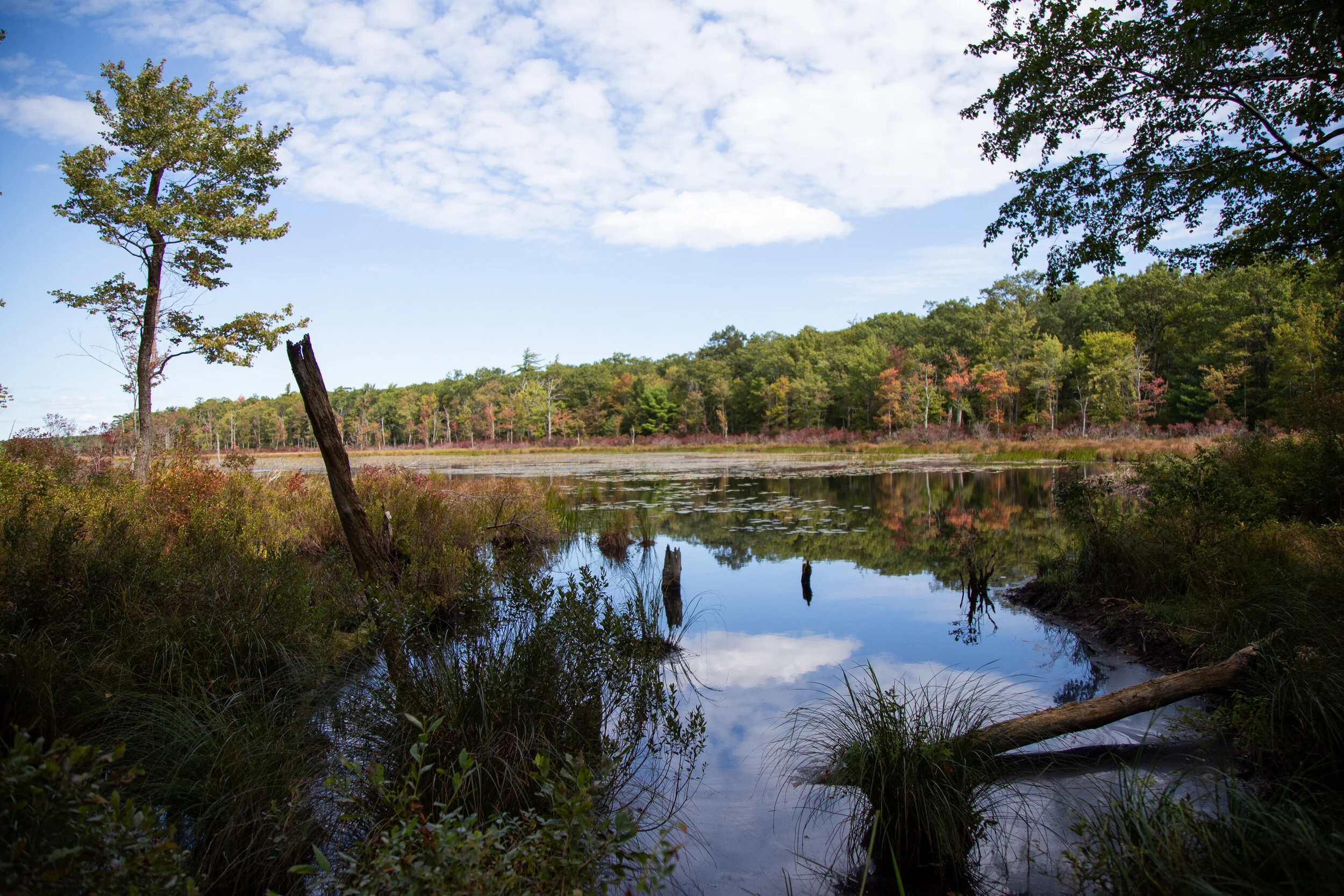
This morning I headed up to the Pocono Mountains to Promised Land State Park in the Delaware State Forest. Promised Land is a huge area with about 50 miles of trails in a very well organized trail system. As per usual, I wanted to hike on a less populated trail, so I looked for the most remote looking area I could see on the map. I found a trail I could access off the 390 from a turnout on North Shore Road where I could link up to the Bruce Lake Trail outside of Promised Land and it would take me to Bruce Lake. According to the park map, the route was mostly a hiking only trail (no bikes) which was a plus, and it was away from the beaches and campgrounds near Promised Land Lake which meant it should be pretty isolated. From the parking turn out I got on the Rock Oak Trail heading east. The path started out wide and grassy through the shaded forest. The ground was a bit rocky as per usual Pennsylvania terrain, but I could still enjoy the scenery and not have to keep looking down to watch my footing. At the first junction I continued eastward as the trail turned into the Telephone Trail. From here it got interesting. I was rock hopping boulders for the majority of this section and bushwhacking through huge towers of rhododendrons. I felt like I was in a jungle, but I definitely was not bored. It was actually fun. As much as I complained about the rocks being a pain in my butt, I did enjoy the test in agility. As I neared the end of the Telephone Trail, I found the junction for the Bruce Lake Trail. This would take me northbound to the natural glacial lake where I could sit and enjoy the scenery before looping around the lake to make my way back. The Bruce Lake Trail started out pretty well maintained, but eventually I was back to bushwhacking my way through. Thankfully, the rocks weren’t that bad. Eventually, I reached another junction to make the loop around the lake. I headed east in a counterclockwise direction. Now the trail was wider and way less overgrown. I could see the lake to my left as I hiked along this beautiful section of trail. As I approached the north side of the lake, the trail came to an opening at the shore. It was absolutely beautiful. All that rock hopping and navigating through brush made it worth it for these views without a soul in sight. I took a nice long break here, had a sandwich and enjoyed the quite. When it was time to return, I made use of the West Bruce Lake Trail heading southbound. This trail was REALLY overgrown and on top of that it was right at the shore of the wetlands so it was super muddy. Luckily, it was still easy to make out the trial and the blue blaze markers/guides were always easy to find. I finished off the day by continuing the loop on the Rock Oak Ridge trail and then eventually the Rock Oak Trial back to the trailhead. It was a fun day. The peace and quiet and views of the lake were definitely worth the effort. I would love to come back again and see more of this area, especially in the next month because the leaves will be changing colors and it will be spectacular.
Today’s adventure took me to Nescopeck State Park. This park sits between two mountains; Mt. Yeager to the south and Nescopeck Mountain to the North. Most of the trailheads are accessed via Honey Hole Road. This is a beautiful area, and I’m still in awe when I’m driving down these Pennsylvania backcountry roads. To start the day I took a walk around Lake Frances. There’s a nice wide loop trail that goes around the whole lake. It’s not a very big lake, just .6 miles around. I didn’t see many people here except for some fishermen. After checking out the lake, I got back on Honey Hole Road and drove to the Wood Frog Loop Trail. There are 200 acres of wetlands in this park, and this trail is an easy 1.1 mile loop around a swamp on a wide grassy path. It’s very serene and relaxing here. After meandering around the loop and taking in the scenery, I drove to the parking turnout for the Mountain Loop Trail. This trail boarders SGL 187 and just off the parking area there’s a beautiful creek that heads into the Game Lands. The Mountain Loop is about 3 miles. There are lots of rocks and uneven terrain very typical of Pennsylvania. I took the loop clockwise making my way steadily up Nescopeck Mountain. This trail must not see much use because it was very overgrown. It also had a lot of spiderwebs. In fact, I almost walked right through the spiderweb of the biggest spider I have ever seen (besides a tarantula). From what I could guess after I got home and looked up Pennsylvania spiders, it was a Marbled Orb Weaver. I watched her spin her web before ducking underneath to pass by. At the top of the loop, the trail turns east. There were a few boulders here which would be a nice place to sit and take a break after the walk up the mountain. As I continued eastward the trail opened up to a sunny, grassy path before descending back into the woods. I didn’t see another human being on this trail (always a plus), but I did scare up a large grouse that took off when she saw me. I also found a praying mantis which eyed me curiously as I took her photo. It was a beautiful day. There’s more to explore here and I am looking forward to coming back.
Today I went back to Jacobsburg State Park. I think this is going to be my “go to” place whenever I don’t want to do a long hike or drive too far. The temperatures were supposed to be in the mid 90s today, and I wanted to be back home in the a/c before that happened. I parked in the parking area just before the bridge over Bushkill Creek on Jacobsburg Road. Since the bridge was closed I made my way on foot to enter the west side of the park at the locked gate heading south across State Park Road. From there, I turned west and followed along Sobers Run on the Red/Green blazed trail. It was still fairly early and it was a pleasant walk in the shade along the creek. I had no real plan to do any mileage today, so I took my time and enjoyed the scenery. I could hear the song of a Wood Thrush and also the locusts chattering high up in the trees. I took the connector trail (yellow/green blazed) to make a loop. I crossed back over Jacobsburg Road and began to follow the trail South. According to the map, the trail should have crossed over Bushkill Creek and taken me back to the parking area. Unfortunately, I think the trail has become overgrown or washed away because I didn’t see anything that resembled a trail on the other side of the creek. I backtracked and walked a short ways on State Park Road to the car. Once back at the parking area, I took a short side trip down to the creek on the Jacobsburg Trail, but even from this direction, I didn’t see a trail on the other side of the creek. Maybe one day when it’s a little cooler I’ll do a bit more exploring off trail to see what I find.
Today I ventured up to the Pocono Mountains to Hickory Run State Park. I was here years ago, but barely remember it. Hickory Run State Park sits on 15,990 acres in Carbon County and there are 41 miles of hiking trails. It’s also home to Boulder Field, a National Natural Landmark. I parked at the turn out off the 534, east of the turnpike overpass. I picked up a park map at the kiosk and examined the area. I was near Hawk Falls which is just a short .6 miles. I decided to make that my first stop. The trail starts off through thickets of tall rhododendrons and descends on an easy grade to Hawk Run. I’m learning that streams here are referred to as a “run”. I crossed over a footbridge and came to an intersection where you can climb up the steps leading to the Orchard Trail or carry on to Hawk Falls. I noticed that the trails are very well marked and have paint blazes on the trees to guide you. I made my way over to the 25 foot waterfall which was flowing nicely. I wondered if these waterfalls ever get down to a trickle as they do in Southern California where we didn’t get much rain. After snapping some photos, I made my way back to the car. From here I drove over to Sand Spring Lake to use the facilities (Flushable toilets and soap in the restrooms! Score!). There were some families with their kids swimming in the lake and the lake was loaded with bright green bullfrogs! I ran back to my car and pulled out the camera for some pictures. After being way more excited over frogs then a person should be, I pulled out the map again to decided on my next trail. I found a one mile trail called Shades of Death. This trail was noted as being the most difficult hiking in the park. I am not sure what is considered difficult here on the east coast, so of course I wanted to find out. The reality is that this trail was mostly full of rough terrain; tree roots, mud, rocks, but nothing overly terrifying to warrant the name Shades of Death. I later learned after reading the park brochure, that the trail was named by the colonists for its dark forests, swamps and rocky soil. So don’t let this name discourage you, I saw many families with small children hiking here. The muddy, rocky trail follows along Sand Spring run and takes you through more rhododendrons just like the Hawk Falls trail. There are notable rock formations and at one point there’s a narrow slot with steps cut into stone that you have to climb up. Along my way I saw many small waterfalls. I was not at a loss for lush greenery. There were a couple of dams and the remains of logging mills which I understand date back to the early 1800s. This hike does not gain much elevation, but it was a very nice hike through the shady forest along the stream. The trail ended in a grassy meadow leading up to the visitors center. I turned around here and returned the way I came. It was a lovely morning and a good introduction of what’s to come on the Pennsylvania trails.