Another cold, icy day. Seems like we’ve had to deal with more ice this year then last year. We headed out to Locust Lake. We’ve had really great weather lately. Mostly blue sky and not the typical winter gray that I remember from last year. We hiked a loop that took us along Locust Creek, up to Broad Mountain then back down. After the hike we stopped to enjoy the icy beach. I’ve never see the beach in the summer and wondered how crowded it gets. Well, no one was here today! So we sat for a while and looked out across the frozen lake watching the ice fisherman before heading home.
We went back to Tuscarora State Park today to see if we could figure out how to do the loop from Lake View, Spirit and Crow trails. After some research, it seemed we’d have to take the street a short way and then reconnect with the trail. This time we headed off on the Lake View Trail heading counterclockwise or west. The trail followed along a road and past by some camping areas. The lake was crystal clear and for once, the weather wasn’t super humid. From the Lake View Trail we picked up the Spirit of Tuscarora Trail. I’ve been on this trail a couple of times and it’s a really beautiful trail. It’s very well take care of and ironically, we happened to bump into its creator, Pap. He was out on the trail cutting back the shrubs and making sure the trail was clear. We stopped and chatted with him for a while and he told us he had created this trail over 30 years ago and has been taking care of it ever since. You can easily see it is a well loved trail. It’s also a very unique area. There’s quite a bit of diversity compared to a lot of Pennsylvania trails which tend to all kind of look the same after a while. The terrain is also less rocky in this region. I’m not quite sure why that is compared to most other Pennsylvania trails, but i wasn’t complaining. After talking with Pap, he confirmed we would have to follow the trail to the street, hop the guard rail and walk up the road a short way if we wanted to pick up the Crow Trail and continue the loop. We took his advice and found our way. It was an absolutely beautiful day. The monarda was flowering in the meadows and it was full of butterflies. We also came upon a majestic larch plantation. It was a really nice hike. As the day went on, it started to warm up and the humidity began to rise. Luckily we were just about wrapping up our hike and ready to head home. It was a great day at Tuscarora State Park. I always enjoy coming here.
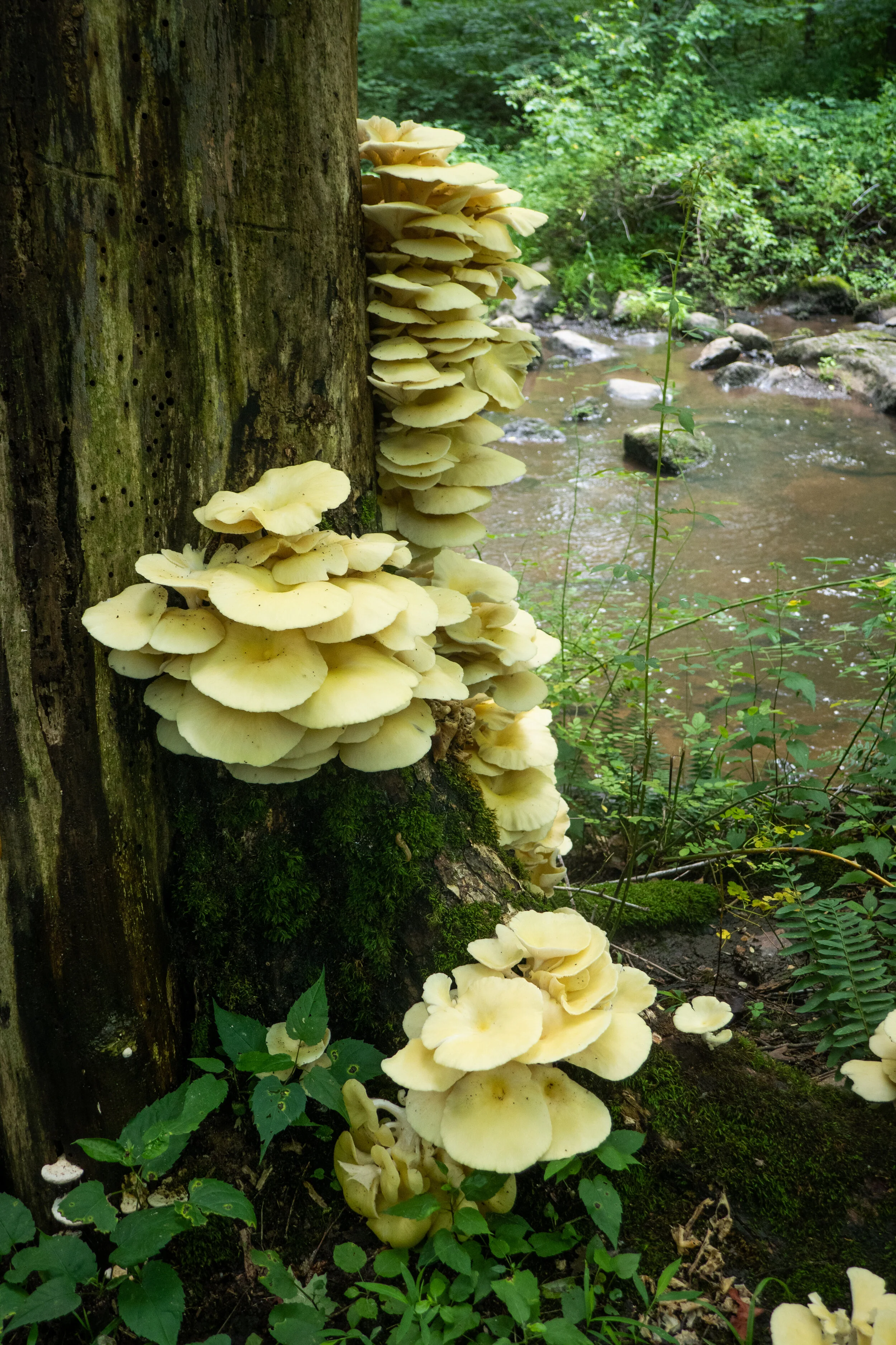
It was another hot and humid day in Pennsylvania. Despite the weather which I am not taking well to, I slathered myself in bug spray and set out on the Old Mill Trail at Nockamixon State Park. The previous evening had brought storms, and sections of the trail were covered in boot sucking mud. I’d gotten myself a pair of Keen Ridge Flex waterproof boots earlier in the year, and they are serving me well. At about .4 miles we arrived at a creek crossing where we boulder hopped over the water to continue along the trail. Along side the creek we spotted an impressive grouping of oyster mushrooms growing up the side of a tree. The trail took us through a forest of hardwoods and in and out of sunny areas of tall grass surrounded by lush, green vegetation. As we hiked, chorus of cicadas surrounded us. I saw a number of dragonflies and butterflies along the route as well. Somehow, we both managed to come off the trail without one tick hitching a ride. Lyme Disease is common in this state and you need to always check yourself for the creepy crawlies after hiking. We could have continued from Old Mill onto the Quarry Trail, but we were already at about 5 miles and I was more then ready to hit the shower. So we headed back and noted to return on a less hot/humid day to get in more mileage. I enjoyed my time exploring the trails here, and I’m looking forward to doing a night kayaking trip out on the lake during the next full moon.
I’ve now spent an entire year hiking in Pennsylvania and can honestly say that the summer months are the absolute worst times to hike in this state. It’s hot, humid and bugs (mosquitoes and ticks) abound. That said, the scenery (lakes, woods, wildflowers) is lovely with plenty of active wildlife (bears, birds, butterflies, snakes, etc.) I will admit it hasn’t been easy trying to adjust from high peak mountains out west to low elevation, woodsy trails of Pennsylvania. I miss a good climb and being rewarded with incredible views. Also, the lack of elevation here means there is no escaping the heat of summer. But I digress. I’m making the best of it and learning to enjoy my surroundings and simply appreciate nature.
This past Sunday we hiked a familiar trail in the Delaware State Forest: Egypt Meadow Lake to the Bruce Lake Natural Area. We had snowshoed here in the winter and so it was nice to see such a dramatic change in scenery. I do love the obvious change of seasons here and seeing how different the trails look throughout the year.
Even though we were on the trail early today, the humidity was still pretty bad. There really is no escaping it. But we finished the hike before 11 am, just as the sun was starting to come out from the clouds and really warm things up. I was happy to get out and enjoy an early morning walk in the woods.
We started our day with an early morning hike on the New Jersey side of the Delaware Water Gap National Recreation Area. We parked at the trailhead for Blue Mountain Lake and planned to hike to Hemlock Pond and then on to Crater Lake, a natural glacial lake left behind from the Wisconsin Glacier approximately 22,000 years ago. It was a beautiful spring morning. The sun was shining and the birds were singing as we headed onto a wide, grassy path which was once a former road for a housing development. The easy trail took us along the northern side of Blue Mountain Lake offering lovely views along the way. At about 2.5 miles, the mostly hardwood forest became a green canopy of tall hemlocks. Soon we reached the shores of Hemlock Pond. The landscape here was incredibly picturesque. We spotted a milk snake sunning itself on the rocks and also noticed a den full of black snakes which if I had to guess were either water or rat snakes. After taking in the scenic landscape and the wildlife, we continued around Hemlock Pond until reaching the connector trail to Crater Lake. The trail made an ascent on a rocky, single track before reaching the Appalachian Trail where we found a vista point with some views. From here we began to circle around Crater Lake then followed a short spur trail down to the shores for a closer look. We then continued on the main path and found Lake Success on the southeast side. The banks of Lake Success were filled with fragrant Lily of the Valley. I know these are not native, but the aroma is amazing and they are also one of my favorite flowers. In the middle of the lake I spotted a beaver dam. As we continued the loop, we crossed the trailhead and parking area for Crater Lake. There were some inviting picnic tables here, so we decided to sit for a bit, have a snack and enjoy the peaceful setting before moving on. When we were ready, we got back on the trail and headed back towards Blue Mountain Lake. This time we hiked along the inner loop trail which took us directly to its peaceful southern shores. I couldn't believe there wasn’t any one here except for one lone fisherman who we had seen at the trailhead very early in the morning. It was such an amazing day. We ended up hiking a little over nine miles which always seems to go by so fast when there’s so much beautiful scenery.
I’m really loving the Delaware Water Gap. There are so many trails here to link together to make the most out of your day. I admit it’s been hard for me to find the challenges I had hiking out west, but I’m finding that there are some places, such as the DWG, where you can get a little climbing in and also link up trails to add some decent mileage. Today we hiked to Sunfish Pond, a 44-acre glacial lake located on the Kittatinny Ridge. It lies within the Worthing State Forest on the New Jersey side of the DWG. We took the steepest, shortest route up to the lake via the Garvey Springs Trail which has a respectable gain of 1,058’ in 1.2 miles. There’s a more gradual ascent up the Douglas Trail from the same trailhead, which we planned to take on the return. Laurel Falls is also a nice feature to see that’s right at the start of the Douglas Trail if you go up that way. It was a somewhat chilly morning, but the sun was out and the ascent got us warmed up fast. The trail leads through a hardwood forest, and I saw some patches of bluets (wildflowers) along the path. As we hiked, two wild turkeys crossed the trail up ahead. The trail became more and more rocky as we got closer to the top of the ridge. We leveled off for a short distance and Sunfish Pond came into view. Next, we made our way onto the Appalachian trail which runs along the western and northern shores of the lake. The trail here was mostly rock hopping large rocks and boulders with a few breaks in between. There were some campsites on the way to sit on a log and enjoy views of the serene lake. There were also some alcoves to climb the rocks out onto the water to get a closer view. I very much enjoyed the scenery here and hiking along the shores. On the western side of the lake there’s a stone monument and a plaque marking Sunfish Pond as a registered natural landmark. We continued following the AT as it moved away from the lake on a wider path that was much less rocky. We reached a backpacker campsite where there were several campers. We then connected to the Douglas Trail and began to descend. When we reached the junction with the Rockcores Trail, we decided to take it northeast and then connect back to the Garvey Springs Trail. The Rockcores Trail passes Laurel Falls on the drainage from Sunfish Pond. There was a steep use trail that made a beeline along the drainage, but I wanted to hike further so we kept on following Rockcores until linking back up with Garvey Springs. It was now about 11:30 am and as we approached the trailhead, I could see that parking was already at maximum capacity. I looked over at Laurel Falls and there were some hikers trying to climb on top of the waterfall. One of them slipped and fell, but luckily was okay. It always makes me wonder what makes people do the things they do. As we made our way to the car, someone was already asking for our parking spot. We packed up our gear and headed out. I had a really nice time on this hike. It had a little bit of a challenge and the lake was a beautiful early morning destination.
Today we ventured out again to take advantage of the abundant snowfall in the Pocono Mountains. This time our destination was the Delaware State Forest. We parked at the trailhead for Egypt Meadow Lake off Route 390 just north of Promised Land State Park. From here we donned our snowshoes and headed out into a winter wonderland. The snow was even deeper than what we had experienced yesterday at Nescopeck State Park. But it was light and powdery and such a delight to walk on. We traveled east along a wide path through a hardwood forest. Soon enough Egypt Meadow Lake came into view. Egypt Meadow Lake was built by the Civilian Conservation Corps in 1935. It’s one of the few undeveloped lakes in Pennsylvania that can only be accessed by hiking. Today it was a sheet of solid ice covered in a veil of pure white snow. As we followed along the main path we came upon a side trail that looked like it would take us in for a closer look. We decided to explore. As we approached the icy shores we saw tracks made by humans leading out across the frozen lake. Ice thickness needs to be at least 4 inches to support the weight of a person up to 200 lbs. It appeared solid enough, so we made our way out onto the lake slowly and carefully. As we ventured further towards the center, expansive views opened up in all directions. It was such a thrill to be standing out there on top of the frozen water and enjoying the lake from this perspective. After taking it all in, we made our way back to the trail and continued following across the outlet of the dam. We then began to ascend on a single track into an exquisite forest of pine. The snowy path undulated gently along the shores of Egypt Meadow Lake and meandered in and out of giant hemlock trees. We passed by rhododendron, mountain laurels and rock formations that were almost hidden by the deep drifts of snow. It was an absolutely beautiful trail. At about 2 miles we came to the bridge that would cross over Egypt Meadow Lake and begin the second half of the loop around its western shores. This section of trail was equally as beautiful as the first half of the loop. We took our time as we snowshoed atop the magical white blanket covering the earth enjoying the beauty of the forest on this incredible winter day.
It’s hard to believe we’re moving closer and closer to spring with all of this snow around. The days are getting longer, but the temps are the coldest they’ve been so far this winter and we’re still receiving snowfall. We took advantage of the latest accumulation and headed up to Nescopeck State Park for a day of snowshoeing. Nescopeck is a beautiful area that we’ve returned to quite a few times since we’ve been on the east coast. We started our day enjoying the views around frozen Lake Frances which was now blanketed in a layer of snow. We turned south onto the Nescopeck Trail on a single track through a hardwood forest in the direction of Mount Yeager. The trail then widened and we made sure to stay out of the cross country ski tracks that were already laid. The snow was powder fluff and over a foot deep; perfect for snowshoes. We continued south until we reached the Creekside Trail. This trail is my favorite in the park. It looked exceptionally beautiful today. Its pristine waters were now mixed with patches of ice and a light dusting of snow. We stopped to admire its beauty and listen to the sound of the quiet forest as delicate snowflakes fell from surrounding Hemlocks. We continued following the creek westward until reaching a crossing where the bridge has been out since summer. We didn’t see a way of getting around it without having to make a water crossing, so we backtracked the way we’d come until reaching the junction for the Nescopeck Trail. From here we continued northeast and onto the Woodland Way Trail which circles around a pond. In the summer you can enjoy watching the turtles sunning themselves here on the rocks. We closed out our day at 5 miles. I’m really enjoying taking advantage of spending time outdoors during these beautiful winter days. I can feel the earth stirring beneath my feet, and life is beginning to awaken. I know soon enough the cold winter days and gray skies will give way to the warmth of the sun. The bare, leafless trees will burst forth in hues of green and the soil will make way for the first of blooms of spring flowers.
Saturday morning we had a lovely walk around Tuscarora State Park. The temperatures were below freezing again, but there was no wind and the day was sunny. We hiked the Spirit Trail which we had done in the summer when it was filled with wildflowers. Today it was covered in a dusting of snow and patches of ice. The trail starts off following along the lake for about a mile ascending through an oak and hemlock forest. We could see views of frozen Tuscarora Lake below and also hear the water shifting under its thick coating of ice. It makes an eerie sound; kind of hard to describe. We then took the loop south heading back down towards Locust Creek where we hiked in and out of rhododendron tunnels. Parts of the creek were frozen solid and others had a coating of ice above with water flowing underneath. We passed by the Spirit Tree which is covered in a green coating of moss and mushrooms, even in the winter. We made our way to a newly added bridge and crossed over the creek to begin another ascent. At the top we came to a clearing with lovely views and an evergreen forest. Before continuing onto the second loop (the trail is actually a figure eight if you look at it on a map), we explored a side trail which ascended the mountain again. I believe would have taken us to the Crow Trail. We’ll have to explore that one on another day. The trail then dropped us back down for more creekside hiking. We crossed another bridge over the creek that had been broken by a fallen tree. When we arrived back at the trailhead, we took a walk down to the lake. By this time there were ice fisherman and ice skaters taking advantage of this beautiful winter’s day. It was a nice contrast to when we had visited over the summer.
Beautiful day in the Delaware State Forest. We started the day by stopping off in Promised Land to check out the Little Falls trail along East Branch Wallenpaupack Creek. It was 18 degrees in the morning, and as I walked I could feel the ice underneath the frozen leaves cracking beneath my boots. The creek was moving fast and there were icicles clinging to the trees. I took a few photos and headed out to the trailhead for Egypt Meadow Lake off the 390. We started the trail heading east in a clockwise direction, but soon came upon an area where the water from the lake had breeched the trail making it impassable. There’s been so much rain over the past few days that it’s caused the snow to wash away and the rivers and creeks to swell. We backtracked and took the trail in the opposite direction. It was a beautiful walk through the forest with rock outcroppings lending spectacular views of frozen Egypt Meadow Lake. The trail undulated gently up and down over the typical rocky Pennsylvania terrain until we reached the junction for Bruce Lake. From here we continued eastward on a wide road with a lot of icy sections that were easy enough to navigate around. We arrived at Bruce Lake which was also frozen over. I tested the water with my boot and it felt solid. I could see footprints of a person and their dog who had ventured out onto the icy lake. We took a short break here to enjoy the scenery, but with the below freezing temperatures we didn’t stay too long before we needed to get moving again. On the way back we took the Panther Swamp trail to reconnect with the Egypt Meadow Trail and returned to the trailhead. The parking lot at the trailhead was still a sheet of ice. It didn’t go above freezing the whole day, but there were no winds which made it a perfect day for winter hiking.
I recently discovered the Graver Arboretum, a hidden gem located in Bushkill Township, Pennsylvania while my husband and I were out for a drive. He noticed a sign, and we decided to stop. The arboretum is used as an outdoor classroom by the biology and other science departments of Muhlenberg College. There are a few trails here and it’s a quiet place to walk and relax. This was our second visit to the arboretum. The first time I didn’t have my camera with me. This time I brought it along. It was a cloudy, overcast day. There were a number of Canada Geese on the pond and the leaves were falling as we walked along the quiet path. It’s a nice place to come to visit when I just want to relax in nature without a long day of hiking.
Today I got up much later then I’d wanted to. It just feels so comfortable here on the east coast as the seasons are starting to change. Nevertheless, I knew if I didn’t get up and out I’d regret wasting the day. I decided to go back to French Creek State Park and explore more of the trails. This time I parked at the Hopewell Furnace National Historic Site so I could walk through the old iron plantation and take in a bit of history before heading off on the Horseshoe Trail. The Horseshoe Trail is a 130 mile trail that runs from Valley Forge to the Appalachian Trail in Harrisburg, PA. Part of this trail passes through French Creek State Park with stops along Hopewell Lake and Scotts Run Lake. I followed the trail west until I reached a junction for the Boone Trail which would take me to the Ridge Trail and the Hopewell Fire Tower on top of William’s Hill. Not far from the junction I came upon some empty cabins. The cabins were not locked, so I went inside to take a look. Each cabin had some old metal bed frames, but nothing else. It was fun exploring around and even a little eerie. To add to my woodsy macabre adventure, I could heard gunshots off in the distance. However I knew those shots were coming from a nearby firing range and there was no need for alarm. After checking out the cabins, I continued on to the fire tower. I hiked up the Ridge Trail to the top of William’s Hill. There was a parking area here, but to my disappointment, I was unable to see the tower because it was blocked by all the trees. I found what looked like a use trail and followed it for a short while, but it was severely overgrown. I’ll have to come back in the winter when the trees drop their leaves and hopefully, I’ll be able to get a better view. The fire tower was built in 1935 by the Civilian Conservation Corps/French Creek Recreation project. Oh well. Better luck next time. I headed back down the Boone Trail which seemed a little more rocky then the way I’d come up and looped back to the Horseshoe Trail passing by Scotts Run Lake then back to Hopewell Furnace. It was lovely, overcast day and an enjoyable hike coupled with some sight-seeing.
This morning I headed up to the Pocono Mountains to Promised Land State Park in the Delaware State Forest. Promised Land is a huge area with about 50 miles of trails in a very well organized trail system. As per usual, I wanted to hike on a less populated trail, so I looked for the most remote looking area I could see on the map. I found a trail I could access off the 390 from a turnout on North Shore Road where I could link up to the Bruce Lake Trail outside of Promised Land and it would take me to Bruce Lake. According to the park map, the route was mostly a hiking only trail (no bikes) which was a plus, and it was away from the beaches and campgrounds near Promised Land Lake which meant it should be pretty isolated. From the parking turn out I got on the Rock Oak Trail heading east. The path started out wide and grassy through the shaded forest. The ground was a bit rocky as per usual Pennsylvania terrain, but I could still enjoy the scenery and not have to keep looking down to watch my footing. At the first junction I continued eastward as the trail turned into the Telephone Trail. From here it got interesting. I was rock hopping boulders for the majority of this section and bushwhacking through huge towers of rhododendrons. I felt like I was in a jungle, but I definitely was not bored. It was actually fun. As much as I complained about the rocks being a pain in my butt, I did enjoy the test in agility. As I neared the end of the Telephone Trail, I found the junction for the Bruce Lake Trail. This would take me northbound to the natural glacial lake where I could sit and enjoy the scenery before looping around the lake to make my way back. The Bruce Lake Trail started out pretty well maintained, but eventually I was back to bushwhacking my way through. Thankfully, the rocks weren’t that bad. Eventually, I reached another junction to make the loop around the lake. I headed east in a counterclockwise direction. Now the trail was wider and way less overgrown. I could see the lake to my left as I hiked along this beautiful section of trail. As I approached the north side of the lake, the trail came to an opening at the shore. It was absolutely beautiful. All that rock hopping and navigating through brush made it worth it for these views without a soul in sight. I took a nice long break here, had a sandwich and enjoyed the quite. When it was time to return, I made use of the West Bruce Lake Trail heading southbound. This trail was REALLY overgrown and on top of that it was right at the shore of the wetlands so it was super muddy. Luckily, it was still easy to make out the trial and the blue blaze markers/guides were always easy to find. I finished off the day by continuing the loop on the Rock Oak Ridge trail and then eventually the Rock Oak Trial back to the trailhead. It was a fun day. The peace and quiet and views of the lake were definitely worth the effort. I would love to come back again and see more of this area, especially in the next month because the leaves will be changing colors and it will be spectacular.
Today I ventured up to the Pocono Mountains to Hickory Run State Park. I was here years ago, but barely remember it. Hickory Run State Park sits on 15,990 acres in Carbon County and there are 41 miles of hiking trails. It’s also home to Boulder Field, a National Natural Landmark. I parked at the turn out off the 534, east of the turnpike overpass. I picked up a park map at the kiosk and examined the area. I was near Hawk Falls which is just a short .6 miles. I decided to make that my first stop. The trail starts off through thickets of tall rhododendrons and descends on an easy grade to Hawk Run. I’m learning that streams here are referred to as a “run”. I crossed over a footbridge and came to an intersection where you can climb up the steps leading to the Orchard Trail or carry on to Hawk Falls. I noticed that the trails are very well marked and have paint blazes on the trees to guide you. I made my way over to the 25 foot waterfall which was flowing nicely. I wondered if these waterfalls ever get down to a trickle as they do in Southern California where we didn’t get much rain. After snapping some photos, I made my way back to the car. From here I drove over to Sand Spring Lake to use the facilities (Flushable toilets and soap in the restrooms! Score!). There were some families with their kids swimming in the lake and the lake was loaded with bright green bullfrogs! I ran back to my car and pulled out the camera for some pictures. After being way more excited over frogs then a person should be, I pulled out the map again to decided on my next trail. I found a one mile trail called Shades of Death. This trail was noted as being the most difficult hiking in the park. I am not sure what is considered difficult here on the east coast, so of course I wanted to find out. The reality is that this trail was mostly full of rough terrain; tree roots, mud, rocks, but nothing overly terrifying to warrant the name Shades of Death. I later learned after reading the park brochure, that the trail was named by the colonists for its dark forests, swamps and rocky soil. So don’t let this name discourage you, I saw many families with small children hiking here. The muddy, rocky trail follows along Sand Spring run and takes you through more rhododendrons just like the Hawk Falls trail. There are notable rock formations and at one point there’s a narrow slot with steps cut into stone that you have to climb up. Along my way I saw many small waterfalls. I was not at a loss for lush greenery. There were a couple of dams and the remains of logging mills which I understand date back to the early 1800s. This hike does not gain much elevation, but it was a very nice hike through the shady forest along the stream. The trail ended in a grassy meadow leading up to the visitors center. I turned around here and returned the way I came. It was a lovely morning and a good introduction of what’s to come on the Pennsylvania trails.