After yesterday’s long journey to the top of Mt. Marcy, we were ready for an easy day. We decided to hit the trail again, but this time tackle a much shorter peak, Mt. Jo. The trail begins across the street from Adirondack Loj and starts off on a flat, gravel path with interpretive signs for the diverse vegetation. It passes by Adirondack Loj Nature Museum before becoming a dirt path that begins the ascent. It was a beautiful morning as the light shined through the trees on this crisp, fall day. And while I wasn’t planning for a steep climb, we did have some work to do to get to the top. After a little over a mile of steep climbing, the trail leveled off just before the summit. Another short scramble and a climb up some helpful ladders and we were at the top of Mt. Jo looking over at Mt. Marcy, where we were just yesterday. Down below we could see Heart Lake and the trees were just beginning to show signs of fall color. We chatted with some hikers at the summit before heading back down. People are always so much happier when you meet them on the trail. Once we got back down, we added a little more hiking with a walk around Heart Lake. We stopped a few times to sit and enjoy the views, listen to the sounds of the wilderness and watch people in their canoes paddling across the lake. It’s in these moments when I feel most at peace. I’m always happy in the mountains. It was a great way to end an amazing couple of days in the High Peaks Region of the Adirondacks and I foresee many more trips to come.
We went back to Bear Creek Preserve today. Last time we were here we were snowshoeing and it was 19 degrees. Looks quite a bit different in the spring. Everything in Pennsylvania is a lush green now and the mountains are filled with blooming Mountain Laurel. We hiked from the main parking area off Rabbit Run following the red trail. It took us down a muddy, rocky service road that was under construction. As we reached a clearing to a power line, I saw a black bear meandering around the open field. We were far enough away to make our presence known by making noise and putting the bear whistle to use. As we did, the bear slowly headed away from our direction and disappeared into the field. We crossed the clearing and headed back into the woods. We then connected to the gray trail where we used the suspension bridge to cross over shades creek. We followed the trail passing in and out of rhododendron tunnels along side the creek enjoying its many cascades. We found the use trail that took us to a very small waterfall just off the main trail and stopped to enjoy the scenery. As we left the creekside, the trail took us back into the hardwoods and a blooming sea of Mountain Laurel. The day was cloudy, but it was beautiful nonetheless and a great day for a hike. I enjoyed seeing Bear Creek Preserve during the spring.
Today we headed out early to explore the Delaware Water Gap National Recreation Area. Our first stop was Dingmans Falls. This is a popular area with a beautiful boardwalk system that provides safe and easy access leading to two beautiful waterfalls. I was aware that this is a popular destination and can become quite busy, so we arrived just after sunrise. The road to the parking area at the Dingmans Visitor Center was closed (they close it during winter), so we parked in the lot just off the 209 and began a short mile walk down Dingmans Falls Road to the trailhead. The road itself was very scenic as it followed Dingmans Creek past tall pines. As we strolled along I saw a lot of downed trees which I later learned were caused by a violent storm in 2018. Soon we reached the Dingmans Falls Visitor Center where the smooth boardwalk trail begins. It crossed over Dingmans Creek and within just a short distance we were treated to a view of our first waterfall of the day, the 80 foot Silver Thread Falls. Silver Thread is tall, narrow and drops over the rocky cliffs in almost a perfectly straight line; hence the name “silver thread”. As we continued on the boardwalk we passed through large stands of rhododendron surrounding us on either side. It gave the trail a jungle-like feeling. In less than a mile we arrived at the majestic 130 foot Dingmans Falls. This waterfall is noted as being the second tallest in Pennsylvania; the tallest is Raymondskill Falls just a few miles up the road. The fast flowing waters tumbled down a gorge carved into exposed bedrock from the Devonian period 365-405 million years ago. We spent some time taking photos and enjoying the views before making our way up a steep wooden staircase to the top of the falls. The views from above were just as spectacular as below as the water spilled down the 130 foot vertical drop. After taking in the scenery and making sure to grab lots of photos, we decided it was time to start heading back so we could enjoy another trail while it was still early. We walked back to the parking area, hopped in the car and headed north on the 209 to the Hackers trailhead on Raymondskill Road where we planned to hike to Hackers Falls and the Cliff Trail. The Hackers trail began on a gravel path leading uphill. As it leveled off we were taken on a pleasant walk through an inviting hemlock forest. We then reached the junction for the waterfall and descended steeply. As we continued to follow the trail, I could hear Raymondskill Creek off in the distance. Soon we were hiking above and parallel to the creek. Within about a mile we reached Hackers Falls. This waterfall was steep but short and shaped like a feather fan. We spent some time taking photos, studying the rocks and enjoying the small but mighty waterfall before making a gentle ascent back up the Hackers trail through more hemlocks and mixed hardwoods. Next, we reached a junction for the Buchanan trail which ran north along a power line. We passed by an abandoned building and a dilapidated trailer home just before reaching a pond. When we arrived at the junction for the Cliff Trail, it was closed due to nesting Peregrine Falcons. We backtracked onto the Hackers Trail to access the Cliff Trail from the opposite direction. This section was open so we followed the trail to the first vista. From here I could see the Delaware River and across to New Jersey. We continued along the Cliff Trail as it travelled along the Raymondskill Ridge offering sweeping views along the way. Several vultures soared at eye-level as we hiked. It was a beautiful sunny day and by the time we reached the parking area, it was already full with people coming out to enjoy this perfect spring day.
We tried to beat the rain on Sunday and take a short hike around Mariton Wildlife Sanctuary. I haven’t been here since fall and today the forest was covered in snow. With the weather having been warmer this past week and the snow starting to melt, I wasn’t expecting to need snowshoes. But the snow was still deep and we ended up putting them on. As we made our way along the trail, we were accompanied by the soft sound of rain falling on the trees and the snow covered forest floor. Despite the gray skies, it was a lovely day; very peaceful and relaxing to be in this serene place on a rainy winter morning.
Saturday morning we had a lovely walk around Tuscarora State Park. The temperatures were below freezing again, but there was no wind and the day was sunny. We hiked the Spirit Trail which we had done in the summer when it was filled with wildflowers. Today it was covered in a dusting of snow and patches of ice. The trail starts off following along the lake for about a mile ascending through an oak and hemlock forest. We could see views of frozen Tuscarora Lake below and also hear the water shifting under its thick coating of ice. It makes an eerie sound; kind of hard to describe. We then took the loop south heading back down towards Locust Creek where we hiked in and out of rhododendron tunnels. Parts of the creek were frozen solid and others had a coating of ice above with water flowing underneath. We passed by the Spirit Tree which is covered in a green coating of moss and mushrooms, even in the winter. We made our way to a newly added bridge and crossed over the creek to begin another ascent. At the top we came to a clearing with lovely views and an evergreen forest. Before continuing onto the second loop (the trail is actually a figure eight if you look at it on a map), we explored a side trail which ascended the mountain again. I believe would have taken us to the Crow Trail. We’ll have to explore that one on another day. The trail then dropped us back down for more creekside hiking. We crossed another bridge over the creek that had been broken by a fallen tree. When we arrived back at the trailhead, we took a walk down to the lake. By this time there were ice fisherman and ice skaters taking advantage of this beautiful winter’s day. It was a nice contrast to when we had visited over the summer.
It was a bitter cold morning, but despite the weather we headed out for a short hike along Sobers Run in Jacobsburg State Park. It was somewhere in the 20s and the winds were blowing steadily which made it feel even colder. We Parked in the turn out just off Jacobsburg Road, crossed the bridge and headed south on the service road that would take us to the creek. We then turned north onto a one track trail which follows along Sobers Run. The trees here are mostly hardwoods and the forest looked completely different from when we had hiked this section of trail over the summer. At about 1.5 miles we reached Keller Road where we crossed a footbridge and circled back south on a long stretch of paved trail until it intersected with the dirt track that would take us closer to the creek. Along the way we discovered some large tree carvings which appeared to be either tikis or jack o’lanterns. I’m not really sure what they were supposed to be. It was a sunny morning and although it was quite chilly, it felt good to get out in the fresh winter air.
Pennsylvania has a good number of nature preserves to explore. Today we headed back up to the Pocono Mountains to the Maple Tract Preserve located near the 115 in Long Pond. The preserve is part of the Wildlands Conservancy Land Trust, and there are about 8 miles of hiking trails within its 680 acres. The area is made up of glacial wetlands, forest, mountain laurel and rhododendron which is so commonly found along the creekside trails of Pennsylvania. We started on the red trail heading southwest which took us past a frozen pond and along a carpet of soft pine needles. The day was mostly cloudy, which I’m learning is pretty typical of a Pennsylvania winter. As we continued we came up on another frozen pond. It seemed pretty solid so I got brave and ventured out onto it. It’s been years since I stood on a natural, frozen body of water. I remember ice skating on them as a kid many moons ago. We then continued along the trail through more forest of hemlock, spruce, larch, rhododendron and mountain laurel. I’m finally starting to be able to identify some of the trees and plants here on the east coast. It’s still very foreign to me since being out west all these years. As we hiked, we came upon some sections of trail that were on boardwalks to get across the wet marshes that were mostly frozen over. At about 2.5 miles we found Tunkhannock Creek. We walked down to the banks to get a better view and take some pictures. From here we followed the red trail west a bit further to enjoy more views of the creek before backtracking and heading north to explore the blue trail. I was really impressed with the scenery at this preserve. I loved the hilly ups and downs of the trail and the varying terrain. We hiked about 6 miles and didn’t see another person the entire day. This preserve is located close to the 80 and also the Pocono Raceway. I would imagine it might get a little noisy in the summer when the raceway is open. Nonetheless it is an incredibly beautiful area to explore.
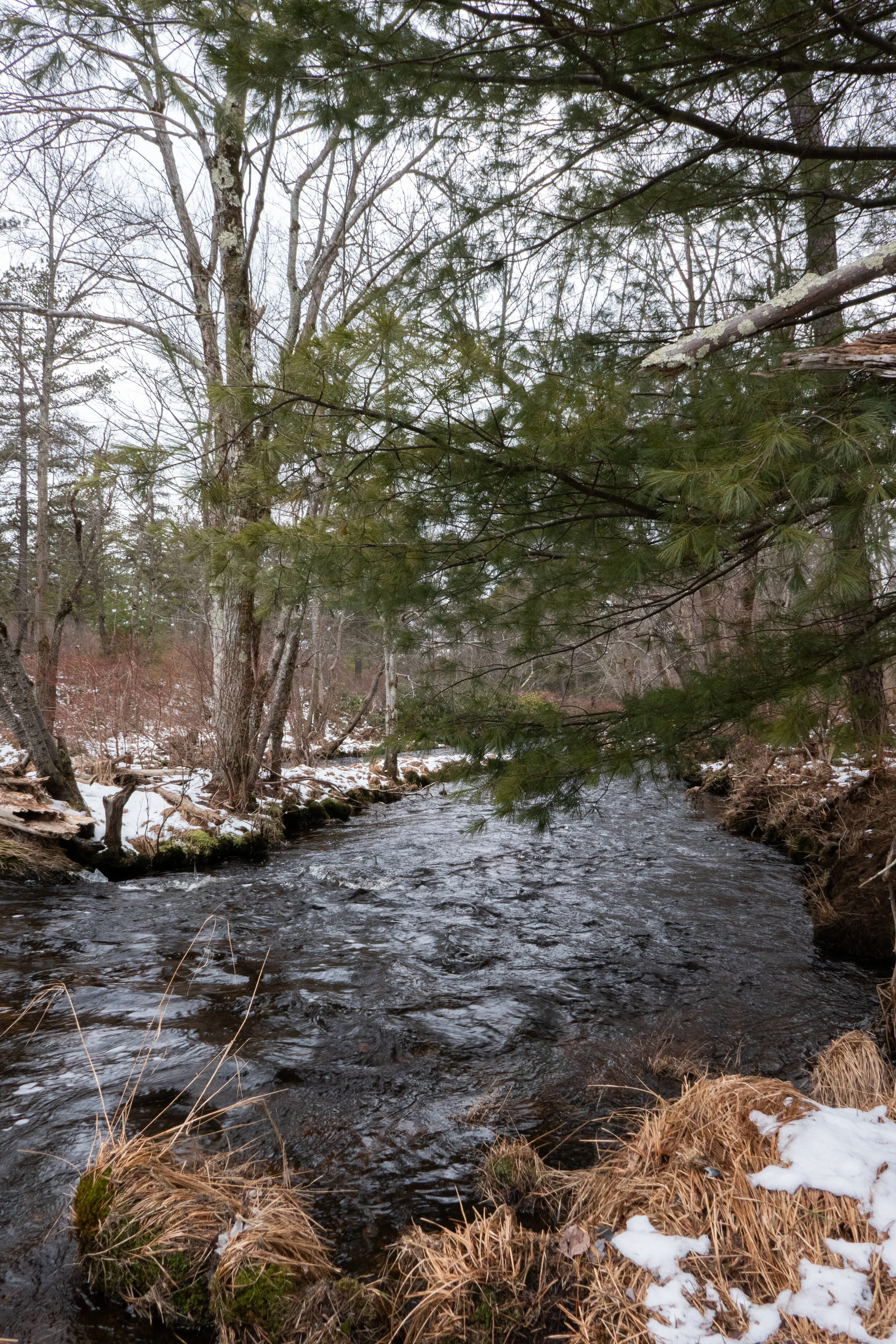
Today we explored some of the trails in Lackawanna State Park. Lacka-wanna is Native American for “the meeting of two streams”. We parked at the trailhead just off Cole Road on the north side of Tunkhannock Creek, crossed the bridge and headed east onto the South Branch Trail. The trail first took us through an open field covered in snow. It looked so magical with the icy snowflakes blowing off the trees like glitter against the blue sky. It was a sunny day, and the snow covered ground sparkled in the morning sunlight as we followed the path. The temperatures were in the mid 20s, but no wind and the sun felt warming as we hiked. The trail then moved closer to the creek entering a beautiful forest of hemlock trees. It followed along the edge of the creek on a narrow track before ascending upward to a wider path. We continued along this track about 2 miles to Messimer Preserve where we found a sign stating, “Sorry We’re Closed”. At this point we turned around and headed back in the opposite direction. On our way we found a spur trail that descended to the creek where we spent time exploring the area and enjoying the small cascades. After our side adventure, we continued back to Cole Road where we crossed and headed west on the Bassett Trail. The trails here were a mix of mud and ice, but the scenery was beautiful nonetheless. We took the Abington Trail to the Lake Shore Trail to get some views of Lackawanna Lake which looked like it was mostly frozen over. We reached a junction for the Lee Hill Trail, took a sharp turn north and began to ascend into more beautiful forest. This trail is also used for mountain biking and I can see why. The trails here were undulating and very enjoyable to hike. Eventually, we met up again with the Bassett Path and closed out the loop. Lackawanna State Park is a beautiful area with many more trails to explore and also a number of preserves in the same vicinity. I’ll surely be back again to see more of this place.
It was Saturday morning, two days after the snow storm and it was time to test out snowshoeing in Pennsylvania. Not really knowing how well the roads would be plowed further north, I decided it was best to stay somewhat local. I checked the DCNR State Parks Winter Reports page for the conditions and snow levels at Jacobsburg State Park. The reports showed 11 inches of snow which was enough for snowshoeing. It was 7 degrees when I woke up. I wasn’t quite sure how that was going to feel. I’m used to Southern California weather. In SoCal this time of year the temperature might (and that is a big MIGHT) drop into the 30s, and then I’d drive to higher elevations for snow and colder weather. In Pennsylvania winter is right outside my door. I suited up in my winter hiking gear and headed out. When I arrived at Jacobsburg, I was surprised to see there were very few cars in the well plowed lot. I thought for sure since this park is so close to town that there would be families with children sledding and many more people enjoying the winter wonderland. There was hardly anyone, and I was not going to complain. I suited up and headed out along the blue trail to get the blood flowing. The snow was more of a hard pack because during the storm, it was mixed with sleet. I followed the blue trail which loops around the edge of the park. I passed a group of cross-country skiers which I’m learning is a popular sport here. I can see why with the wide trails and easy going terrain. I reached the junction for the trail that would loop me around to the bridge that crosses over Bushkill Creek and headed into Henry’s Woods. The creek was starting to freeze over with icicles clinging to the rock walls along the creek. The giant hemlocks towered above. It was just beautiful. I finished the loop with about 3 miles RT. It was a nice warm up hike and introduction of what to expect after experiencing my first Pennsylvania snow storm in 20 years.