My favorite time of day is the hour before sunrise. I got up early today to enjoy the woods in Jacobsburg State Park just as the sun was coming up.
Click “Read More” below for more photos.
Read Moretrails
My favorite time of day is the hour before sunrise. I got up early today to enjoy the woods in Jacobsburg State Park just as the sun was coming up.
Click “Read More” below for more photos.
Read MoreQuick walk at Lake Towhee this evening. This is a 50-acre lake in Bucks Count Pennsylvania. I was here one time last summer for a short visit. Next time I’ll be sure to bring my binoculars because it seems to be a great place for birdwatching. I saw lots of waterfowl and plenty of red-winged black birds. There are some very short trails in the surrounding woods and we walked the short paths searching for spring wildflowers. First to be spotted was Blood root (Sanguinaria canadensis). Native to Pennsylvania, its name refers to the red-orange sap that comes from its broken stem and root. Native Americans used this plant as a dye and an insect repellent. (I really should try the latter, as the east coast is full of bugs.) Blood root is a spring ephemeral and grows in woodlands throughout the Northeast. It blooms in April and its flowers open in full sun and close at night. I've been seeing a lot of these on the trails.
Next up I saw Rue Anemone, (Thalictrum thalictroides). Another native to Northeastern Pennsylvania. The flowers are found in spring woodlands and I observed some with white petals while others were a light pink to lavender color. These little flowers bloom for a short time from April to May.
The yellow flowers posted here are Lesser celandine or pilewort and not native to Pennsylvania. They come from the buttercup family Ranunculaceae and are native to Europe and Western Asia. I believe they are marked as an invasive species to the area.
This is a nice place to stop for a quick walk or a quiet meditation by the water.
Click “Read More” below for more photos.
Read MoreAfter yesterday’s long journey to the top of Mt. Marcy, we were ready for an easy day. We decided to hit the trail again, but this time tackle a much shorter peak, Mt. Jo. The trail begins across the street from Adirondack Loj and starts off on a flat, gravel path with interpretive signs for the diverse vegetation. It passes by Adirondack Loj Nature Museum before becoming a dirt path that begins the ascent. It was a beautiful morning as the light shined through the trees on this crisp, fall day. And while I wasn’t planning for a steep climb, we did have some work to do to get to the top. After a little over a mile of steep climbing, the trail leveled off just before the summit. Another short scramble and a climb up some helpful ladders and we were at the top of Mt. Jo looking over at Mt. Marcy, where we were just yesterday. Down below we could see Heart Lake and the trees were just beginning to show signs of fall color. We chatted with some hikers at the summit before heading back down. People are always so much happier when you meet them on the trail. Once we got back down, we added a little more hiking with a walk around Heart Lake. We stopped a few times to sit and enjoy the views, listen to the sounds of the wilderness and watch people in their canoes paddling across the lake. It’s in these moments when I feel most at peace. I’m always happy in the mountains. It was a great way to end an amazing couple of days in the High Peaks Region of the Adirondacks and I foresee many more trips to come.
Read MoreToday was the vernal equinox, a time when day and night are in equal balance. To honor the official beginning of spring, we set out for a sunrise hike to the top of Mt. Wismer in Monroe County. We parked at the trailhead just off the 447 to take the blue blazed trail. This is actually the easy route. There’s a more challenging hike from the trailhead off Gravel Road. Today we were interested in doing photography and catching the light of the sunrise. It was a crisp, cold morning and as the sun began to rise up over the mountain, we made our way down a wide open path which led to the blue blazed trail. The trail heading up had patches of hard snow and ice. As we hiked along the trail became a single track and I noticed large moss covered boulders above us dripping with melting ice. Spring surely is here. The trail was rocky and wet with leaves as it gently ascended through large rhododendrons and hemlock trees. We followed along the escarpment of the mountain, and as it curved to the east we were almost blinded by the blazing sun coming up over the horizon. At the top we were rewarded with wide open views. From here we could see Gravel Pond, Camelback Mountain and even more impressive, the obvious gap of the Delaware Water Gap. The light was absolutely brilliant. We meandered around the overlook enjoying the open landscape before heading north on an unmarked trail. We hiked along the path through hardwoods, and then found ourselves in a beautiful grove of hemlock. The sunshine shimmered through the towering trees, and I heard the call of a tufted titmouse. Soon we were at the close of the loop and back at the trailhead. It was still very early and neither of us were ready to head home, so we opted to take another hike. We decided to venture into the Delaware State Forest to Stony Run. We parked the car at an unmarked trailhead off Snow Hill Road and headed onto a wide grassy trail. The trail began to descend southward and became more rocky. As we hiked I spotted two white-tailed deer off in the distance who quickly disappeared into the woods. Soon the trees began to thicken with evergreens and I could hear the sound of fast moving water. A wooden bridge came into view and we were now at Stony Run. From the bridge I watched the run as it tumbled and danced over moss-covered rocks. We explored the area for a bit then found a comfy spot to settle in, have a snack and enjoy the scenery. After our little break, we started to make our way to the trailhead. We took a short off-trail adventure over to a large rock outcropping with some nice views. Three large black vultures sored high above us in the sky. By now the day had warmed up to about 55 degrees, but it was time to make our way back and head home. It was a beautiful way to kick off the first day of spring.
Click on “Read More” below for more photos.
Read MoreThe first stop on our Sunday adventure was Targa Falls, a natural waterfall found on the Broadhead Creek. The waterfall is easily accessible from a parking area just off the 447, or you can hike to it from the Paradise Price Preserve. I wanted to see and photograph it in the very early morning sunshine, so we chose the easy drive up access for today. Someday I plan to return to hike in from the west side of the preserve. We parked the car and as I stepped out I could hear the loud rushing waters. Just a few steps more and there it was, this incredible flowing creek roaring past me over large, rocky boulders. The early morning sunlight danced on the white foaming rapids, and the tall hemlocks swayed in the breeze on the banks. It was a beautiful sight just a stone’s throw away from the road. At that moment I honestly felt a little guilty having such a natural wonder within such easy reach. Being used to the rugged mountains of Southern California, I’m not used to having this kind of quick and easy access to something so beautiful as a roaring waterfall. I got my hiking legs out west where you have to earn your views by trekking miles into the wilderness and climbing to precarious mountain tops to view such spectacular places; no cell service, no wifi and only your two legs to rely on to get you there and back. Pennsylvanian’s are so very lucky in this respect.
After enjoying the waterfalls, we hopped back in the car and headed to the trailhead for the Red Rock Loop and Mt. Sophia. The Red Rock Trail is part of the Mount Airy Trail Network and sits on lands protected by a conservation easement held by Paradise Township. At the trailhead there’s a helpful map laying out the topography of the hike, and the trail begins just beyond the kiosk. It starts out on a gravel path leading up stone steps. Right away I noticed the beautiful oak trees and not far into the trail we arrived at a vernal pool. I imagined it would soon be filled with salamanders, wood frogs and other critters. The trails here seemed to be very well kept (save for some downed trees), and they were so pleasant to walk on. So much so that I forgot how rocky the Pennsylvania terrain usually is. We soon arrived at a well-marked junction for the Red Rock Loop and decided to continue northwest directly towards the junction for the top of Mt. Sophia. Along the trail there were large stands of mountain laurel which I am so excited to see bloom in late spring and early summer. This will be my first spring on the east coast in over 20 years. Soon the trail became covered with patches of icy snow and we reached the junction for Mt. Sophia. The trail took us up gently graded switchbacks and as we continued upward, there were helpful wooden steps peeking out from underneath the snow. As we approached the summit, an impressive forest of large pine and hemlock came into view. The sunlight radiated through the majestic trees. I spent some time exploring the summit and the views. From here I could make out the ski runs on Camelback Mountain to the south and more views to the north. We followed the trail a little further as it looped us around in a circle with a convenient “Exit” sign pointing back to the direction in which we came. We took our time hiking down enjoying the views through the beautiful pines and the sunshine. We then arrived at a junction for Red Rock Spur #1. It led us to the site of an old car from the 50s that was flipped upside down and settled into a ditch. It made me wonder what its story was and how it even got up there. There were some old logs that looked like they’d make a perfect place to sit down and enjoy the fresh mountain air, so we sat down and took a break. It was a windy day and I was enjoying listening to that groaning, creaky sound the trees make when they sway against each other in the wind. After our break, we continued along the trail and the winds started kicking up even more. We reached a junction for Red Rock Spur #2 (another outer loop) and began a gentle ascent. We passed by some interesting rock formations before noticing a vintage car graveyard nestled below us, deep in the woods. Had this been summer, we would have never even seen it since the trees would have concealed it with their leaves. We decided to move in closer to explore. There were three rusty cars who had clearly been here for a long time; their final resting place nestled into the forest. We took some photos and then got back on route, enjoying more views to the south as we hiked. The trail made its way down some lovely switchbacks until finally we were back at the junction for the Red Rock Trail on which we had started. This was a wonderful day hike. I really enjoyed my time here and again, it felt like wilderness even though we were so close to civilization. I’d like to come back again and explore more of the spurs and see it when the mountain laurel is in full bloom.
Click on “Read More” below for more photos.
Read MoreToday our adventures took us to Hickory Run State Park. The last time we were here it was fall when the leaves were showing off their vibrant autumn colors. I was excited to see how it was going to look in winter covered in snow. We got an early start so we could avoid the crowds. This area has become quite popular over the years, and can be very overcrowded on weekends. The parking area for Hawk Falls off route 534 was empty when we arrived. We parked the car, geared up in our microspikes and made our way onto the icy trail. Light snow showers began just as we started the hike. The trail was packed down into a hard sheet of ice. But the path was wide and not very steep, so it was safe to travel with just light traction. A foot bridge crossed over Hawk Run, and we continued past steep rock walls lined in hemlock and rhododendron. We followed a short use trail to a rock outcropping that gave us a nice view of the top of the falls tumbling down the side of the rocky ledge. It looked so beautiful as soft white snowflakes fell from the sky. In just a short .6 miles we arrived at the bottom where the 25 foot Hawk Falls plunged into a clear pool of cascades. We spent some time here enjoying the magnificence of this natural waterfall. Near the falls, we noticed some ice formations along the high cliff walls and decided to explore them. The moss covered ledges and large icicles dripped with melting water. We then got back on the trail and followed along Mud Run until we reached the junction for the Orchard Trail. We turned east and made an ascent up a hill and onto a ridge with nice views that continued through a hardwood forest. Eventually, the trail dropped us down again on some switchbacks into a windy thicket of rhododendron. It led us to a large rock outcrop just above Mud Run where spectacular cascades tumbled over large rocks and boulders. There were many use trails branching off to offer closer views of the beautiful water flow. The trail then turned northeast and we started to ascend moving away from the creek. Now higher above Mud Run the trail was a mix of patchy snow and muddy pools of water flowing down the mountain. Our waterproof boots came in handy here. Eventually, the trail looped west and back into the hardwoods where it was mostly snow. We closed the lollipop loop and made our way back over the ridge and down to the Hawk Falls trail to return the way we came. By this time many people were starting to arrive. We saw several large groups slipping and sliding on the ice attempting to make their way to the falls on the icy trail. When we arrived back at the parking area, there were at least 20+ cars with more lining up to get a spot. I was grateful to have been able to enjoy a quiet morning in solitude along this beautiful trail.
Click on “Read More” below for more photos.
Read MoreThe D&L Trail is a 165-mile multi-use trail running from Wilkes-Barre to Bristol. The northern terminus is located in Mountain Top, Luzerne County with its highest point being 1,785’. The trail follows the same route that the anthracite coal once took from mine to market and winds along the Lehigh and Delaware Rivers. As you walk the towpath, there are interpretive signs that mark points of interest on the trail. Since the trail runs along the river, there’s lots of wildlife to be seen here. I walk this path some days in the early mornings and there’s plenty of species of birds including Bald Eagles which are making a comeback in the area. Bald Eagles are listed as protected and no longer considered endangered or threatened. Last week I happened to see one flying upstream along the canal. I didn’t see any Bald Eagles today, but I did catch a glimpse of a Red Fox making its way across the trail. I walked about 2 miles to Hope Road where there’s a washout apparently left over from Tropical Storm Isaias. It’s not impassable, but I made this my turnaround point since I was short on time this morning. The D&L National Heritage Corridor is full of history and is a great place to come for fresh air and exercise when you just need to get out for an easy walk on the trail.
Read MoreThis morning I went to Promised Land State Park. It looks so different then when I was here at the end of September before the leaves started changing. I still can’t get over the amazing colors. I started the morning with a walk around Conservation Island. It was very peaceful early in the morning and I sat down at one of the benches that are conveniently placed along the path to enjoy the views of Promised Land Lake. As I gazed across the water at the lakeside cabins, it gave me the feeling of being in an old town in New England. The walk around the island was short, but packed with spectacular color. When I returned to the trailhead, I got back in the car and made my way to Lower Lake Road. I pulled into the turnout for the Village Trail, but there were two hunters getting out of their truck with their rifles which is not something I’m used to or comfortable with. I decided to go to a different trailhead instead. I continued a little further up the road and parked at the turnout for the Loggers Trail. After consulting the park map I decided to hike over to Little Falls which on the East Branch of Wallenpaupack Creek. I really enjoyed this section of the hike. It was gorgeous hiking along the creek. Eventually I left the beauty of the creek and made my way west on the Spike Trail. I followed the Spike Trail to the Saw Mill Trail which ran alongside a deer enclosure. Deer enclosures are used to prevent deer “browsing” which is basically eating and killing vegetation. The weather was warm today, but there was a light mountain breeze. Even even though there are no dramatic mountain summits with views here like there are in California, I got the sense that we were at a high point on top of the mountain with a little bit of elevation. After looking at the topography, we were at about 1,700 feet. It was a quiet day to hike around the Pocono Mountains. I imagine it will be a busy weekend with everyone coming up to see the fall foliage.
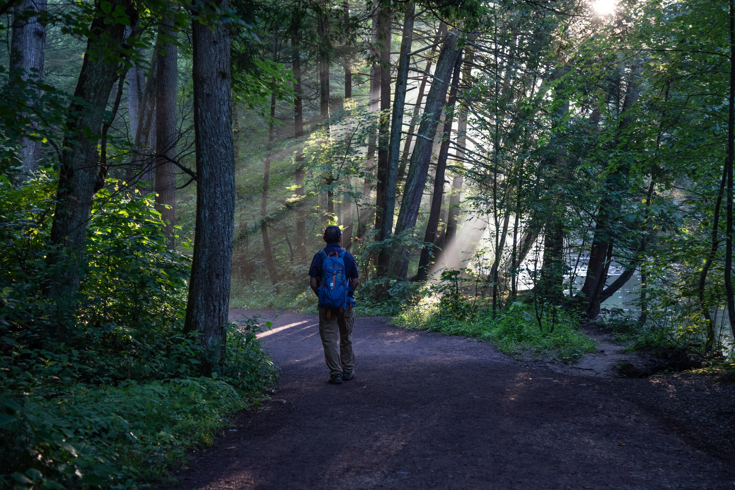
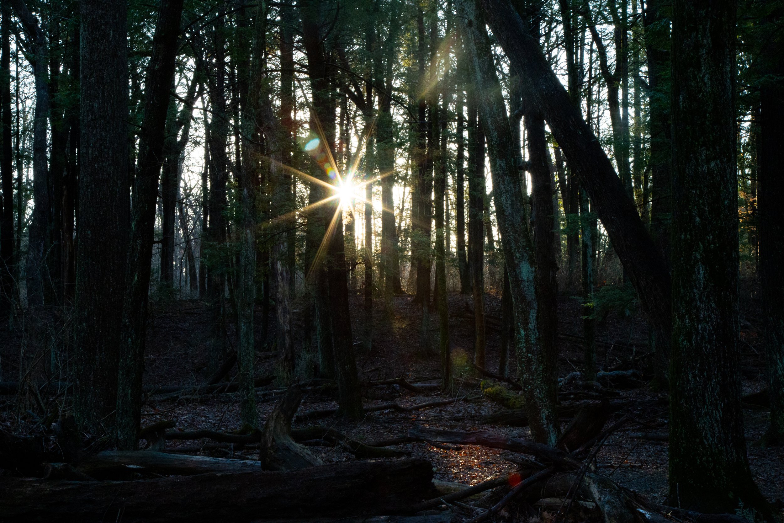
Read MoreToday I woke up before sunrise and headed out for a walk around Jacobsburg State Park* in Nazareth. Jacobsburg State Park offers a 19 mile network of trails ranging from deciduous forest to open fields and streams. Its diverse habitats host many species of butterflies, birds, reptiles, mammals and amphibians.
Today I was interested in photographing the early morning light in Henry’s Woods, an old growth forest consisting of tall stands of hemlock and white oak.
I arrived at the main parking lot off Belfast Road around 6:30 am. There was only one other car in the lot as I began my walk along the wide dirt path leading into Henry’s Woods. The forest was dark but rays of morning sunlight pierced through the trees making for some interesting light. The great Hemlock and White Oak trees towered above my head. The air was humid but cool as I meandered alongside Bushkill Creek taking photos of the lush greenery and the wildflowers. At the end of the Henry’s Woods Trail I reached a fork and followed it northeast to the Jacobsburg Trail which crosses over Belfast Road and onto a wide, grassy path. I followed along the Jacobsburg Trail which runs parallel to highway 33 until it turns southwest and crosses over a bridge above Engler’s Run Creek. I went a little too far and ended up at the parking area on State Park Road. There are a lot of interconnecting trails within the park, and it can get confusing. But if you have a general sense of direction and a map (which you can find at the main parking lot kiosk), you’ll figure out where you are. From here I backtracked and veered off the wide path to explore one of the overgrown use trails that lead down to Engler’s Run Creek. There wasn’t a good spot to ford the creek (unless you were on horseback), so I went back up the path and did a lollipop loop back onto the Jacobsburg Trail and eventually back through Henry’s Woods. By this time it was around 8 am and joggers and dog walkers were making their way onto the trails. It was a lovely morning to spend a few hours enjoying the quiet hours of the park.
*A quick little history about Jacobsburg: In 1792 William Henry II purchased land at Jacobsburg and built a gun manufactory. Henry II acquired the land from the heirs of Jacob Hubler who founded the community which is now called Jacobsburg. The famous Henry rifle was once crafted here, and the Henry family’s small arms industry played an important role in the American Industrial Revolution.
Read MoreIt had been a long couple of months locked away in a city apartment with the Covid pandemic looming over the world. On top of everything I was preparing for a move to eastern Pennsylvania. I was able to get in a few short, local hikes in Griffith Park before I left California, but no wilderness or desert hiking for months. Being away from the backcountry took a toll on my mental and physical well being. It broke my heart to cancel all my plans in Joshua Tree, Idyllwild and the Eastern Sierra, and I was not able to bid what I loved most about California, which were its high-elevation trails, wilderness and desert backcountry a proper farewell. But now I have arrived on the east coast and as the world is beginning to return to what people are referring to as “the new normal”, I am finally starting to feel more like myself again.
Tonight my husband and I began our journey to exploring nature on the east coast. Even though I grew up here, seeing Pennsylvania as an adult is seeing it with a new perspective. We started off with a short walk on a nature trail not far from our home called the Monocacy Way Trail. I used to walk this trail when I lived here over 20 years ago. It has now become part of Historic Bethlehem’s 10.9 mile long Heritage Trail which was designed to give Bethlehem city explorers a taste of Bethlehem history from its Moravian roots to its industrial heyday of the Bethlehem Steel.
We started at the trailhead at Illick’s Mill* across from Monocacy Park. The trail begins as a paved walkway but quickly turns into a proper dirt track. The first thing I noticed is how much greener everything is compared to Southern California. It’s quite a different color pallet. As I walked the trail became a symphony of birdsong; Gray Catbirds, Wood thrush, Carolina Wren and American Robins. There are many use trails along the path if you want to veer off the main trail and walk along Monocacy Creek. Wildflowers are plentiful here with Forget-me-nots, Honeysuckle, Day Lily, Milkweed and Aster. The trail winds along the creek and eventually crosses over the train tracks. I then passed by an open grassy meadow full of thistle and grazing bunnies. At about .8 miles I arrived at Schoenersville Road. If you cross Schoenersville Road, you will continue on past the Burnside Plantation. It was already dark by this time, so we headed back. As we did the fireflies started to light up the trail, just as I remembered from when I was a kid. This is a nice little nature walk bursting with wildlife such as deer, rabbits, box turtles, birds, etc. Great for a quick dose of nature any time of day.
*A little history about Illick’s Mill: The grist mill was built on the Monocacy Creek by John Peter and his son Joseph in 1856. At that time it operated as a flour and feed company. The Mill changed hands many times over the years opening and closing its doors. In 1935, the Bethlehem Water Authority took over the Mill and the Civilian Conservation Corps and the Works Progress Administration constructed Monocacy Park. Then in 1965 the Mill was restored and reopened as a music venue appealing to Lehigh Valley teenagers. It closed its doors again in 1973. Over the years, the Mill continued to change ownership. But what I remember most about Illick’s Mill were the years it hosted a haunted house attraction run by the Bethlehem Jaycees in the 80s and 90s. In the year 2005, the Mill was added to the National Register of Historic Places. As of today the Mill is home to the Appalachian Mountain Club’s Mid-Atlantic Conservation Office and is available for meetings and events through the City of Bethlehem.
Read More