The Lee and Virginia Graver Arboretum of Muhlenberg College is a great place to come for a quick walk. I’ve come to know the conifers here quite well over the time I’ve spent visiting. I particularly enjoy the Pitch Pines and also the Bald Cypress with its unique roots or “knees” as they’re called.
The arboretum serves as an outdoor laboratory for course activities and field work for the students of Muhlenberg College. It’s also free for the public to enjoy. Autumn is a particularly beautiful time of year here, as the trees change into their fall colors.
Dr. Lee and Virginia Graver were nature lovers and conservationists who cleared thick brush and woods to create this beautiful environment. Here you’ll find ferns, mushrooms, rhododendrons, wildflowers, native and rare trees and over 150 species of conifers.
Today I was super excited to come across a large patch of Jack-o’-lantern mushrooms (Omphalotus olearius). These mushrooms are poisonous if you try and eat them, but they’re a wonderful sight to see considering this time of year.
The trees remind us that we are shifting into the dark half of the year. Soon the vibrant, golds and yellows will be replaced with earthy brown and bark as the trees rest deep in the earth until Persephone emerges and spring will return once again.
Woke up to a foggy morning today. I knew the forest at Mariton would look beautiful in the fog since it sits on top of a hill overlooking the river. I grabbed my camera, hopped in the car and headed out to enjoy the morning.
A quick morning walk around Jacobsburg State Park this morning to check out what was blooming and spot some butterflies. At the start of the trail which is just off the side of a busy road, I immediately saw a fluttering of tiny wings. This, I’m pretty sure was the Summer Azure butterfly. I could, of course, be totally wrong here, as there’s also a Spring Azure which looks almost identical. (At least to me as a novice citizen scientist and long-time butterfly enthusiast.) I crouched in the bushes along side of the road to get my photos as cars drove by either not noticing me at all or if they did, they probably thought I was just some crazy person. But I managed to get some pretty decent shots of the tiny little beauty at the very beginning of my walk. As I continued along the trail, I saw quite an abundance of wildflowers in bloom including: dames rocket, solomon’s plume, wild rose, buttercups, golden alexander, fleabane and forget-me-nots just to name a few (Thanks iNaturalist!). Along my route I spotted some interesting mushrooms which I later ID’d as Petticoat Mottlegill. Quite a dainty little name for a mushroom that is noted to mostly grow on poop. I guess this would make sense since I was on a horse trail. It was a lovely morning and I enjoyed the walk and fresh air to start my day.
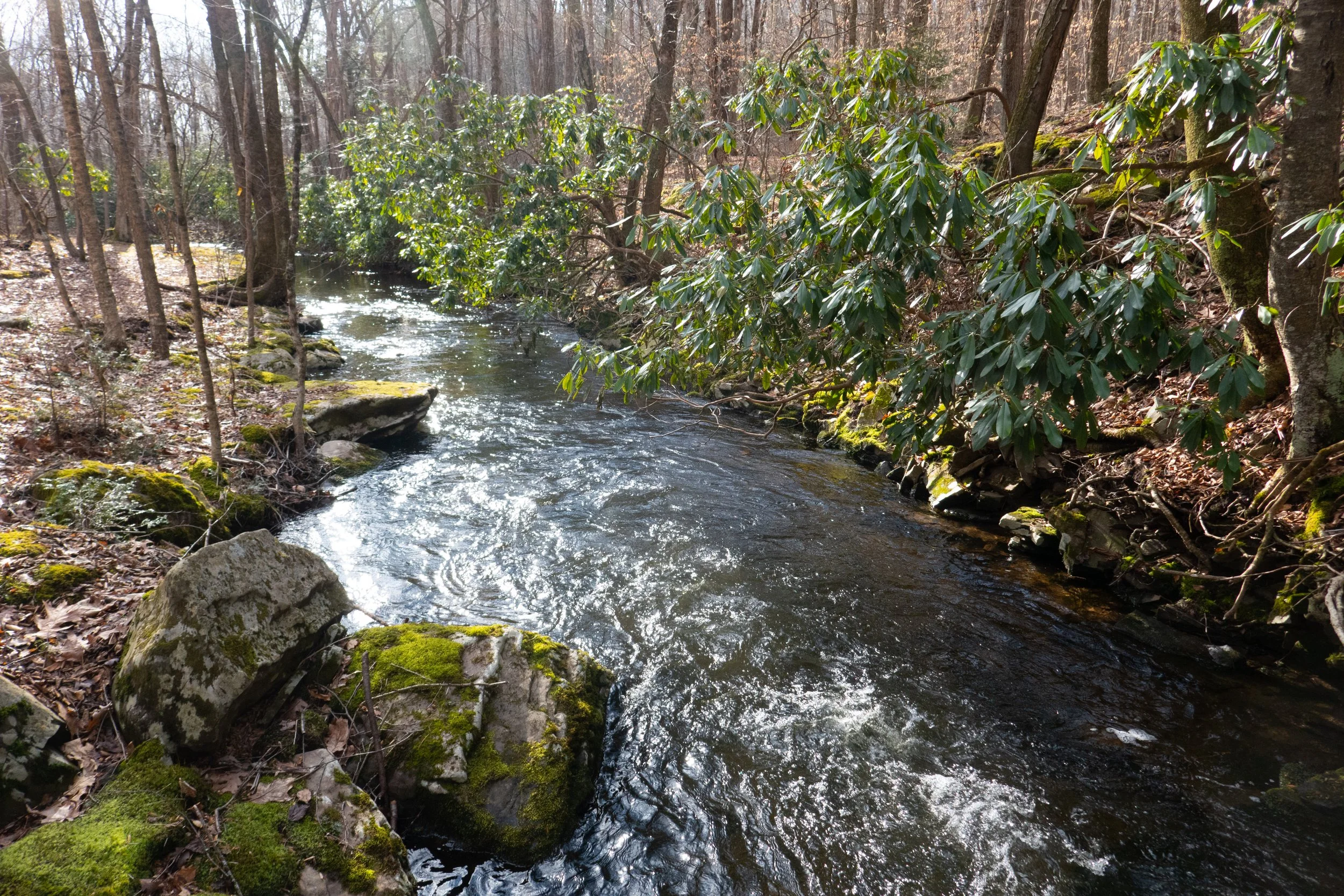
This is one of my favorite Nature Preserves in Paradise Township the Pocono Mountains. I’ve been here several times and keep coming back to see the changes throughout the seasons. There’s always something new to experience along this very short hike of about 3 miles. Today’s weather was cloudy and a little on the chilly side. The sun popped in and out of the clouds throughout the morning. It cast beautiful light across the moss covered rocks along the cascading Cranberry Creek. Soon the trails here will be covered with bright red-orange Red Efts (a second stage eastern newt). It was a lovely morning and a nice way to start the day.
This was more of a walk then a hike. It was cold today. Even a little too cold for me, and I love winter. But we still wanted to get outside. This hike to Dingmans Falls is more of a walk then I hike. You’re walking a flat boardwalk the whole way - except for the road to the trailhead which is now closed so you have to walk the road to get to the start of the trail. Silverthread is the first waterfall you see on this hike. It was completely frozen over and we saw some ice climbers making their way up it. Then we walked over to see Dingmans falls. This waterfall is the 2nd largest in Pennsylvania at 130 feet. The tallest in Pennsylvania, also in the DWG, is Raymonskill which is 178 feet tall. Dingmans wasn’t totally frozen yet, so no climbers on it. We took some photos and then made our way back. Felt good to get out, but today wasn’t the day to spend too much time on the trail. Really enjoyed this little sight seeing excursion and it was a treat to get to see these frozen waterfalls
Perfect weather today. Took a short walk around Nescopeck State Park. A couple of the bridges were out along the Creekside trail. Must have gotten washed away in the last storm. Beautiful day, great weather. Fall color is still holding on.
Today we hiked in the Pinchot State Forest which is named for Gifford Pinchot who played a founding role in America’s conservation movement. The Pinchot State forest is approximately 50,000 acres and encompasses five different counties. There are many hiking trails within this forest, and today we barely scratched the surface with a short hike in the Thornhurst Track on the Pine Hill Trail. The Pine Hill Trail led us to a vista point where there’s a wooden observation tower. You can climb the stairs to the top and overlook some of the surrounding area which in the summer (as with most of Pennsylvania’s ‘views’) is mostly looking at the tops as trees. It was a very nice hike and I hope to explore more of this forest in the future, as there are many trails with a lot of miles to cover including the 26 mile Pinchot Trail loop which is a popular backpacking excursion.
Ended the four day weekend with a hike around the Trexler Nature Preserve. It was the last Sunday with hunting allowed in Pennsylvania, so we kept to the safer areas for outdoor recreation. I have to say there were some pretty decent hills to go up (and down). I have yet to see very many switchbacks here in Pennsylvania. When the trail goes up it’s pretty much just a straight shot. So while there really isn’t much in the way of altitude, these hills don’t mess around with their steepness.
Today I had a quiet morning walk around Mariton Wildlife Sanctuary. It looks much different now with the trees changing colors and losing their leaves. The meadow that was so vibrant with wildflowers and active with wildlife was still except for a lone late season butterfly. The morning was crisp and it felt good to get out and walk up and down the steep hills to warm up. At the end of the hike I stopped at the bird blind to watch some birds on the feeders. This is always a quiet place to come and it’s nearby so I don’t have to drive too far. I suspect once all the leaves fall there will be some views down to the Delaware River. I’ll have to come back in December (if not before) and see.
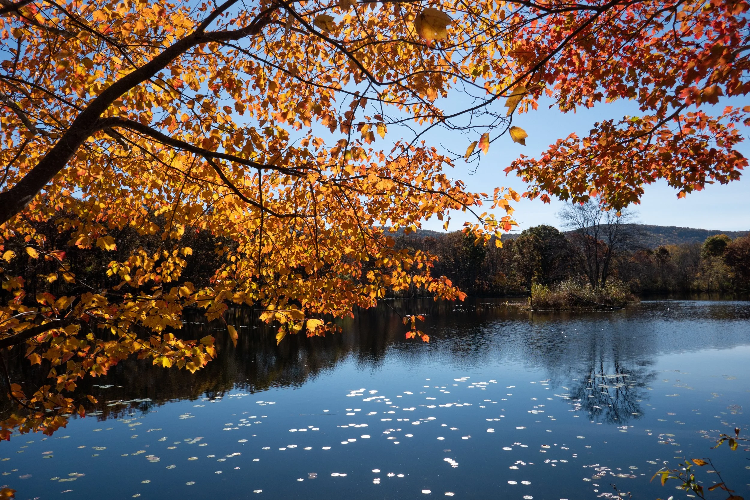
I recently discovered the Graver Arboretum, a hidden gem located in Bushkill Township, Pennsylvania while my husband and I were out for a drive. He noticed a sign, and we decided to stop. The arboretum is used as an outdoor classroom by the biology and other science departments of Muhlenberg College. There are a few trails here and it’s a quiet place to walk and relax. This was our second visit to the arboretum. The first time I didn’t have my camera with me. This time I brought it along. It was a cloudy, overcast day. There were a number of Canada Geese on the pond and the leaves were falling as we walked along the quiet path. It’s a nice place to come to visit when I just want to relax in nature without a long day of hiking.
This morning I went to Promised Land State Park. It looks so different then when I was here at the end of September before the leaves started changing. I still can’t get over the amazing colors. I started the morning with a walk around Conservation Island. It was very peaceful early in the morning and I sat down at one of the benches that are conveniently placed along the path to enjoy the views of Promised Land Lake. As I gazed across the water at the lakeside cabins, it gave me the feeling of being in an old town in New England. The walk around the island was short, but packed with spectacular color. When I returned to the trailhead, I got back in the car and made my way to Lower Lake Road. I pulled into the turnout for the Village Trail, but there were two hunters getting out of their truck with their rifles which is not something I’m used to or comfortable with. I decided to go to a different trailhead instead. I continued a little further up the road and parked at the turnout for the Loggers Trail. After consulting the park map I decided to hike over to Little Falls which on the East Branch of Wallenpaupack Creek. I really enjoyed this section of the hike. It was gorgeous hiking along the creek. Eventually I left the beauty of the creek and made my way west on the Spike Trail. I followed the Spike Trail to the Saw Mill Trail which ran alongside a deer enclosure. Deer enclosures are used to prevent deer “browsing” which is basically eating and killing vegetation. The weather was warm today, but there was a light mountain breeze. Even even though there are no dramatic mountain summits with views here like there are in California, I got the sense that we were at a high point on top of the mountain with a little bit of elevation. After looking at the topography, we were at about 1,700 feet. It was a quiet day to hike around the Pocono Mountains. I imagine it will be a busy weekend with everyone coming up to see the fall foliage.
It was a perfect day to explore more of Hickory Run State Park. This is a beautiful park with so much history. We started the day off by hiking past the Manor House, the former dwelling of Samuel Gould. In the 1800s, the Goulds were the primary landholders of the region and owned many sawmills here. We past the Manor House and headed onto the Fourth Run Trail. This is the longest trail in the park, but today we diverted onto the Stage Trail which was once a stagecoach road that went from Bethlehem to Wilkes-Barre. The Stage trail took us to to the Saylorsville Dam where we followed the winding paved road across the ford and then back to the parking area. It was a lovely walk and I enjoyed meandering along enjoying the fall foliage. Once back at the trailhead I wanted to check out the old Hickory Run Cemetery. This small cemetery in the woods sits on top of a hill and most people aren't even aware that it's here. The cemetery is a place of rest for the unfortunate folks who lost their lives in a flood that devastated the community of Hickory Run on October 30, 1849. The story goes that the woods are haunted by Elizabeth Gould who lost her life on that tragic night when a dam gave way. "Lizzie" was just 11 years old. She was the daughter of Isaac and Susan Gould who were early settlers of the area. The family lived in a small cabin built along side the stream. When the dam broke the cabin was lifted up off its foundation, carried downstream and submerged in the rushing waters. When the water passed Susan was able to break a hole in the roof to get all of her children out except for one... Lizzie. When rescuers arrived, Susan claimed she heard Lizzie calling out, but no one else could hear the cries. Lizzie was later found deceased beneath a pile of rubble near the house. In the weeks ahead, Lizzie's brother Winefield would also pass away due to exposure from the night of the flood. Winefiled is also buried here next to Lizzie. The Legend goes that Lizzie is not at rest and park visitors have reported seeing her ghost roaming through the park or playing along Hickory Run. Others claim to still hear her cries. I paid my respects and headed back to the trailhead. It was such a lovely day and I wasn’t ready to leave just yet. I did one last trail which was a short loop on the Sand Springs Trail and returned back via the Hickory Run Trail. It was another great day to be outside enjoying nature and the fresh mountain air.
Hickory Run is a beautiful State Park. I remember coming here years ago with my parents and walking the peaceful trails. Back then there were no crowds. Nowadays the park has become quite popular, especially on weekends. There are so many trails in this park, but it appears the two most popular hikes are Hawk Falls and the Shades of Death Trail. I hiked both of those earlier in the year and they were both lovely trails. But now that I’m starting to learn the lay of the land here on the east coast, I have discovered so many other beautiful trails and not just the ones that seem to get so much attention on social media.
It was a cloudy, overcast day and the drive up to the Pocono Mountains on the I-80 was abundant with fall foliage. I planned to start my hike on the Fireline Trail which was noted in the park brochure as having a picturesque overlook of the Lehigh River and Lehigh Gorge State Park. About .5 miles into the hike I arrived at the overlook. The view down to the river did not disappoint and neither did the endless colorful foliage. I then continued my way along the Firelinetrail until I reached the junction for the Skyline Trail. Skyline took me on a narrow path working its way across the side of the mountain with continuous views of the Lehigh River to the west. It was a beautiful trail and I had very nice views of the surrounding mountains, again full of that gorgeous fall color. From here I intersected with the Hickory Run Trail, which as it’s name promised, took me along Hickory Run. I walked along the run enjoying the peaceful sound of the small stream until intersecting with the Switchback Trail. The Switchback Trail climbed back up the mountain to Skyline and then Fireline before arriving back at the trailhead. Before leaving the park, I took a short trip over to see a small chapel that was built in the 1800s. It sits tucked away in the woods just off the side of the road. I got out to explore for a bit and came upon the abandoned Manor House structure. Both buildings are structures left of the town that was once known as Hickory Run. There is quite a bit of history here and you can read up on it on the Pennsylvania Department of Conservation & Natural Resources website. I hope to get back to this area again to do more exploring, especially now with our beautiful weather and amazing autumn colors.
This weekend I went back to Stoney Valley to find the old coal mining cemetery. I parked just off Gold Mine Road and began the 3.5 mile walk to the junction with the AT on the Stoney Valley Rail Trail. This time I detoured off the main trail and made my way down to the Evening Branch Beaver Swamp to get a better look at it. I saw some frogs, but no luck seeing any beavers. I walked back up to the rail bed and veered off again when I reached Sand Spring. Sand Spring is true to its name with its sandy waters flowing out of the mountainside. It was a lovely day and temps were in the low 60s, perfect for hiking. When I arrived in Rauch Gap, I headed south on the AT in search of the cemetery. It wasn’t too hard to find. There’s a junction off the AT with a sign. Last time I was here I just didn’t hike in far enough to see it. There are only three readable headstones left in the cemetery; however, there are 100s buried here. These old coal mining towns have such a fascinating history. I can only imagine what it must have looked like in the 1800s. Along the way back up to the AT, I veered off trail again to check out more ruins of the town. I found lots of old stone building foundations hidden away in the woods. Once back on the AT I decided to check out the water crossing at the Beaver Dam. There’s a diversion to get around it about 1.6 miles east on the Stoney Valley Rail Trail for thru hikers. On the way to the crossing, I saw another hiker who said she tried to cross the dam but was unsuccessful. It was obvious, because she was wringing out her clothes! When I reached the beaver dam, I could see what an ordeal it would be to try and cross. Lots of deep mud and not exactly a short crossing either. There were trees growing up out of its waters and all kinds of wildlife including a couple of otters. Beaver swamps are a very strange sight to see coming from California where everything is so dry. This isn’t something I’d see too often (if ever) along the west coast trails, but on the east cost wetlands seem to be quite common. The light here was amazing as it changed and reflected off the murky waters. I spent a good amount of time here walking around exploring my surroundings before heading back up to the AT where I found a couple of campsites. I stopped near the creek to have a snack and enjoy the peacefulness of the wilderness. It was a quiet day and it was a while before I saw any other people pass by. After the break, I went back up to the rail trail and up to the Summit Siding rail bed which I had visited last time I was here. I followed it further out this time until I got tired of hopping over boulders and trees. It was very overgrown. Since I was here, I went back down to see the bridge piers at Rauch Gap again before getting back on the main rail trail. There was one more trail I’d seen last time that I wanted to check out before heading back. I found the red blazed trees off the rail trail and got on the path. I followed it north until finding a sign on the ground that said “to upper rail trail”. I am guessing this would have taken me up to the original rail bed. This trail was even more over grown, so I decided to turn around and head back. It was a really great day. There is still much to see in this area, so I’m sure I’ll be back again.