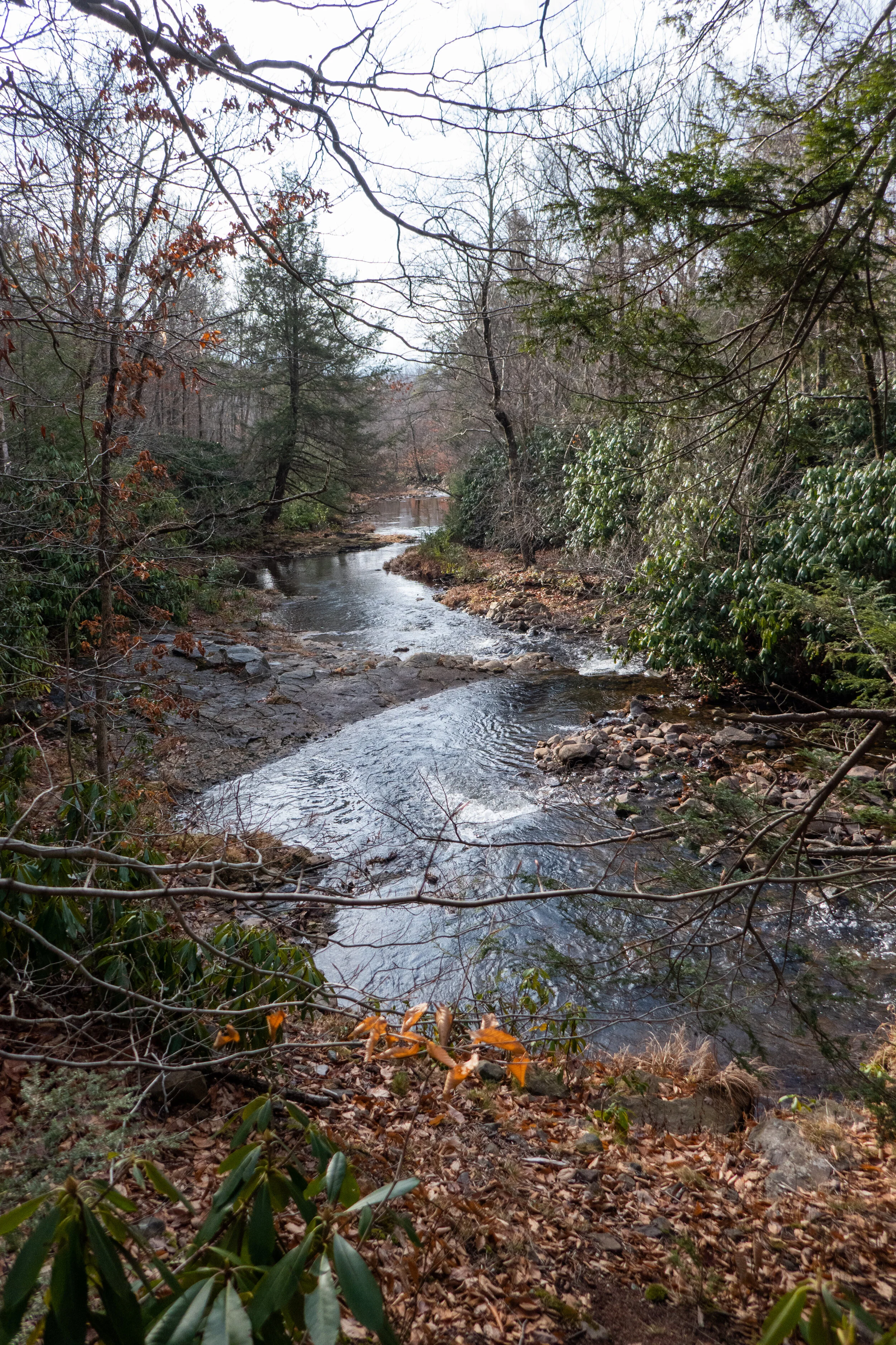
Today we hiked the Dick and Nancy Eales Preserve on Moosic Mountain. It looked quite a bit different then when we were here in the winter when it was covered in snow. We started the hike on the Blueberry Trail passing through stunted pitch pines, oak and blueberry. We then followed the Stonehenge Trail through a large garden of boulders where we connected to the After Five Trail following along large rock slabs. From here we dropped down to check out the O’Connor reservoir and then took Gene’s Trail to the Bruised Ego Trail closing the loop at a little over 8 miles. It was a nice day. The clouds kept the sun from making it too hot and the humidity wasn’t quite as bad as it’s been most of the summer. It was a nice hike with some variety in the terrain and scenery.
It was a rainy start to our Sunday morning, so we waited for the rain to stop before heading out about mid-morning into the Pocono Mountains. Our destination this time was Swiftwater Forest Preserve in Paradise Township. We found the trailhead off Donaldson Road and made our way onto the trail into a beautiful forest of pine. The soft pine needles covering the ground were like walking on a soft carpet. It was a really nice feeling after traversing all the rocks on the AT the day before. The walk through the forest was nice and easy. Along the trail I noticed many different kinds of mushrooms and blooming wildflowers. We passed through a section of mixed hardwood with Shagbark Hickory, Maple and Oak. There were also some interesting rock outcroppings. After hiking around the inner loop trail, we followed the outer loop. Along this path we found a short spur which lead to an old chimney and a fireplace that must have been part of a cabin at some point long ago. There was also an old out house that had been left behind. The forest here was quiet, peaceful and so relaxing. It was a perfect hike for a lazy Sunday.
The first stop on our Sunday adventure was Targa Falls, a natural waterfall found on the Broadhead Creek. The waterfall is easily accessible from a parking area just off the 447, or you can hike to it from the Paradise Price Preserve. I wanted to see and photograph it in the very early morning sunshine, so we chose the easy drive up access for today. Someday I plan to return to hike in from the west side of the preserve. We parked the car and as I stepped out I could hear the loud rushing waters. Just a few steps more and there it was, this incredible flowing creek roaring past me over large, rocky boulders. The early morning sunlight danced on the white foaming rapids, and the tall hemlocks swayed in the breeze on the banks. It was a beautiful sight just a stone’s throw away from the road. At that moment I honestly felt a little guilty having such a natural wonder within such easy reach. Being used to the rugged mountains of Southern California, I’m not used to having this kind of quick and easy access to something so beautiful as a roaring waterfall. I got my hiking legs out west where you have to earn your views by trekking miles into the wilderness and climbing to precarious mountain tops to view such spectacular places; no cell service, no wifi and only your two legs to rely on to get you there and back. Pennsylvanian’s are so very lucky in this respect.
After enjoying the waterfalls, we hopped back in the car and headed to the trailhead for the Red Rock Loop and Mt. Sophia. The Red Rock Trail is part of the Mount Airy Trail Network and sits on lands protected by a conservation easement held by Paradise Township. At the trailhead there’s a helpful map laying out the topography of the hike, and the trail begins just beyond the kiosk. It starts out on a gravel path leading up stone steps. Right away I noticed the beautiful oak trees and not far into the trail we arrived at a vernal pool. I imagined it would soon be filled with salamanders, wood frogs and other critters. The trails here seemed to be very well kept (save for some downed trees), and they were so pleasant to walk on. So much so that I forgot how rocky the Pennsylvania terrain usually is. We soon arrived at a well-marked junction for the Red Rock Loop and decided to continue northwest directly towards the junction for the top of Mt. Sophia. Along the trail there were large stands of mountain laurel which I am so excited to see bloom in late spring and early summer. This will be my first spring on the east coast in over 20 years. Soon the trail became covered with patches of icy snow and we reached the junction for Mt. Sophia. The trail took us up gently graded switchbacks and as we continued upward, there were helpful wooden steps peeking out from underneath the snow. As we approached the summit, an impressive forest of large pine and hemlock came into view. The sunlight radiated through the majestic trees. I spent some time exploring the summit and the views. From here I could make out the ski runs on Camelback Mountain to the south and more views to the north. We followed the trail a little further as it looped us around in a circle with a convenient “Exit” sign pointing back to the direction in which we came. We took our time hiking down enjoying the views through the beautiful pines and the sunshine. We then arrived at a junction for Red Rock Spur #1. It led us to the site of an old car from the 50s that was flipped upside down and settled into a ditch. It made me wonder what its story was and how it even got up there. There were some old logs that looked like they’d make a perfect place to sit down and enjoy the fresh mountain air, so we sat down and took a break. It was a windy day and I was enjoying listening to that groaning, creaky sound the trees make when they sway against each other in the wind. After our break, we continued along the trail and the winds started kicking up even more. We reached a junction for Red Rock Spur #2 (another outer loop) and began a gentle ascent. We passed by some interesting rock formations before noticing a vintage car graveyard nestled below us, deep in the woods. Had this been summer, we would have never even seen it since the trees would have concealed it with their leaves. We decided to move in closer to explore. There were three rusty cars who had clearly been here for a long time; their final resting place nestled into the forest. We took some photos and then got back on route, enjoying more views to the south as we hiked. The trail made its way down some lovely switchbacks until finally we were back at the junction for the Red Rock Trail on which we had started. This was a wonderful day hike. I really enjoyed my time here and again, it felt like wilderness even though we were so close to civilization. I’d like to come back again and explore more of the spurs and see it when the mountain laurel is in full bloom.
I’m finding some really great nature preserves here in the Keystone state. This past Saturday we ventured off to explore the Nothstein Preserve located in Paradise Township in Monroe County. The hike took us through a variety of different terrain, along the ravine of Cranberry Creek and up to a red rock quarry with views extending from east to west across the ridge to the surrounding preserves. We started at the trailhead off Cranberry Creek Road and headed north on a wide path in a counter clockwise direction. The forest was mostly hardwood dappled with tall hemlock trees. Immediately my ears were filled with the pleasant harmony of morning birdsong. We passed by marshes, bogs and small tributaries until we reached a primitive bridge crossing over the pristine waters of Cranberry Creek. We took a moment to branch off and explore its banks and the surrounding feeder creeks before continuing on a single track where we began to ascend gently upward. The trail reached an intersection where we turned northwest. I spotted some train tracks above us running parallel to our path. We made several primitive creek crossings over the crystal clear waters flowing down the mountain and over thick, bright green moss. Now the trail began to descend southwest. The forest became dense with hemlock, and I could hear the sound of rushing water flowing just beyond the trees. The path opened up to reveal another bridge crossing over the fast moving Cranberry Creek. Lined with rhododendron just beyond the bridge, the terrain became a snow covered single track leading us upward above the ravine. We made our way up the trail being careful on the icy patches of snow until reaching a vista of the beautiful cascading waters below. I made sure to get some photos from above, but I wanted to take a closer look. We then backtracked and made our way to a section of trail following along the edge creek where we could enjoy a closer perspective of the sights and sounds of the waterfalls and tumbling cascades. Eventually, we backtracked crossing over the bridge once again and up through the hard packed snow back to the top of the ravine. Soon, the trail began to move away from the creek and the forest became even more dense with tall stands of hemlock and oak. We crossed over more small tributaries being careful not to slip on the moss covered rocks. I’m not sure if it was the tall stands of pine or the way the sunlight was shining through, but this section of trail reminded me a little bit of my beloved Angeles National Forest. It was another lovely section of trail. The path widened again and took us under a canopy of pine. The trail became a bed of soft pine needles beneath our feet. As we travelled up the slope we were led to an old stone red rock quarry. Two large ravens suddenly emerged from the trees and soared across the blue sky above. Again, I felt at home as I was reminded of my life in California where there were always ravens to accompany me along my hikes in the higher elevations. As we traversed along the edge of the quarry, we were treated with sweeping views across the gorge and the ridge beyond. I was awe struck at how a place so beautiful can be so close to civilization. We spent some time exploring around the quarry before moving on, back into the hardwoods and finally looping back down to the woodland path on which we started. It was an absolutely amazing day and a beautiful preserve full of wild, natural beauty to explore and admire.
Today our adventure took place at the Dick and Nancy Eales Preserve at Moosic Mountain. Pennsylvania has some very beautiful preserves, and I was super excited to see this one. I’d been waiting for the right day to visit and today was the day! The sun was shining, the skies were blue and while the temperatures were still below freezing, the winds were fairly low. The Eales Preserve is noted as being one of the best places in the northeastern United States to experience a ridge-top heath barrens. What is a ridge-top heath barrens you ask? I didn’t know either. A heath barrens is a dwarf shrubland or shrub-savanna which can also have stunted trees such as pine and oak. Barrens are great habitats for a wide array of birds, butterflies, moths and other wildlife. The rare sallow moth and barrens buckmoth have been observed at this particular preserve. The Eales preserve was once slated to become a business park. Thankfully, this did not happen and the land is now protected by the Nature Conservancy, a global environmental nonprofit. As we arrived at the trailhead, I immediately noticed the expansiveness of this place. I also saw two ravens playing on the wind and calling back and forth to each other. I knew this was going to be a great hike. We grabbed our packs and cameras and headed out onto the Blueberry Trail. Right at the start of the trail I was immediately awe struck by the beautiful white birch trees and the incredible, stunted pitch pines. I followed along the narrow broken path making my way carefully through the ice, hard packed snow and large post-holes where others had walked. Along the trail there were also patches of exposed rock slab where the snow had completely melted. The varying terrain made it a challenge to walk. Snowshoes would not have worked here, so we used microspikes for added traction. The trail gently gained elevation and quickly opened up to expansive views of the ridges and valleys below. These are the most impressive views I’ve seen since I’ve been in Pennsylvania, and I was loving every moment. As we hiked along the trail we passed by low-lying shrubs such as blueberry and huckleberry. Stunted oak trees still holding to their autumn leaves rattled in the wind. As we reached the high point on the mountain I noticed wind turbines off in the distance. I later learned this was the Waymart Wind Farm in Wayne County. The trail then turned northwest and began to descend along hilly undulating terrain. We then reached a wide open road surrounded by beautiful white birch until connecting with the Stonehenge Trail. Once again on a narrow trail, we meandered through a hardwood forest lined with impressive, massive rock formations. We crossed a small stream and were again surrounded by the openness of the barrens. From here it got a little confusing. We wanted to connect to the Conglomerate Trail, but with the large snow drifts covering the rocks that had the blazed trail markers we ended up slightly off trail. After a quick navigation check with map and compass we began to make our way in the direction of where the actual trail would be. After post-holing through the deep snow drifts, we were again back on route. That was exhausting! By this time the day had warmed up to 26 degrees which to me really didn’t feel that cold. (This California girl must be getting used to the Pennsylvania winters already!) This was an absolutely beautiful and unique preserve and not something I would have ever expected to see in Pennsylvania. As we made our way back to the trailhead I was already making note to add this magical landscape to my list of places to return to during all seasons.
It’s hard to believe we’re moving closer and closer to spring with all of this snow around. The days are getting longer, but the temps are the coldest they’ve been so far this winter and we’re still receiving snowfall. We took advantage of the latest accumulation and headed up to Nescopeck State Park for a day of snowshoeing. Nescopeck is a beautiful area that we’ve returned to quite a few times since we’ve been on the east coast. We started our day enjoying the views around frozen Lake Frances which was now blanketed in a layer of snow. We turned south onto the Nescopeck Trail on a single track through a hardwood forest in the direction of Mount Yeager. The trail then widened and we made sure to stay out of the cross country ski tracks that were already laid. The snow was powder fluff and over a foot deep; perfect for snowshoes. We continued south until we reached the Creekside Trail. This trail is my favorite in the park. It looked exceptionally beautiful today. Its pristine waters were now mixed with patches of ice and a light dusting of snow. We stopped to admire its beauty and listen to the sound of the quiet forest as delicate snowflakes fell from surrounding Hemlocks. We continued following the creek westward until reaching a crossing where the bridge has been out since summer. We didn’t see a way of getting around it without having to make a water crossing, so we backtracked the way we’d come until reaching the junction for the Nescopeck Trail. From here we continued northeast and onto the Woodland Way Trail which circles around a pond. In the summer you can enjoy watching the turtles sunning themselves here on the rocks. We closed out our day at 5 miles. I’m really enjoying taking advantage of spending time outdoors during these beautiful winter days. I can feel the earth stirring beneath my feet, and life is beginning to awaken. I know soon enough the cold winter days and gray skies will give way to the warmth of the sun. The bare, leafless trees will burst forth in hues of green and the soil will make way for the first of blooms of spring flowers.
We started out the year with a hike to Tobyhanna Falls in the Austin T. Blakeslee Natural Area. Pennsylvania has so many waterfalls, I haven’t even scratched the surface of what there is to discover. The weather reports were calling for freezing rain later in the day, so we got up and out early so as not to risk it.
The Austin T. Blakeslee Natural Area was once home to Harrison Amusement Park which entertained the community along the Tobyhanna Creek. What was then known as Toby Park had a carousel, skating rink, swimming pool, dining hall, penny arcade, sporting fields and a creekside beach. It was destroyed in a flood in 1955.
Today the area is open to hikers with a small network of trails that take the hiker along Tobyhanna Creek to the scenic Tobyhanna Falls.
We started at the trailhead off the 115 heading west along the Creek Trail. The first section of the hike takes you through a beautiful stand of tall spruce trees. A short half a mile walk then leads to the waterfall. The falls aren’t very tall, but they are mighty. It’s quite a spectacle to see. The fast moving water was tinted with an amber color which is caused by the tannic acid produced by hemlock and spruce along the banks of the creek. It was a beautiful site to start off the new year. After taking it all in, we continued west. At about .9 miles Tunkhannock Creek flows into Tobyhanna. We looped around north heading away from the creek on the Highland Trail and into a beautiful coniferous forest.
It was a wonderful morning and this is a beautiful area to explore in just a few short miles. We got back in plenty of time to beat the weather.
Beautiful creekside hiking at Bear Creek Preserve this weekend! This has been my favorite hike in NEPA thus far. We started from the trailhead at Rabbit Run Lane on the red trail and connected to the gray tail heading south along Shades Creek. This section of trail was just beautiful with many cascades flowing into deep, clear pools, waterfalls and undulating trail through rhododendron jungles, in and out of hemlock forest and mossy wetland. Before reconnecting to the red trail and heading back north, we crossed over Shades Creek on a really cool suspension bridge. The terrain for most of this hike was rocky and slippery with wet leaves, but I'm getting used to my feet taking a beating on these east coast trails and learning to slow down a bit and take my time. East coast hiking is very different from out west. There may not be much elevation to gain, but I’m starting to find some locations that feel a little more remote where we can track some decent mileage. We followed the red trail back to the trailhead and closed the loop at about 7 miles RT. Absolutely beautiful place to explore.
Today I headed back up to Jacobsburg State Park. It’s nearby and such a wonderful place to take in some nature. I parked in the main parking lot and took the Hazard Trail. I remember hiking this with my dog when I was a kid in the snow and ice. In the summer months, it’s really not much of a hazard. The trail is a single dirt track and it’s well maintained. There’s even a set of steps to take you up one of the steeper sections. The trail climbs easily above Bushkill Creek and there are nice views looking down to the water. At about a half mile I came upon a beautiful meadow filled with Yarrow and Common Milkweed. There were many birds here enjoying the first rays of sunshine. I could hear Eastern Towhee, Brown Thrasher and Gray Catbirds. I turned south and followed the path through the meadow which is part of the Homestead Trail. This trail skirts around the edge of the park on the southeast side. It was partly cloudy today making the walk around the open grassy areas very pleasant. The dewy grass and cool breeze felt so refreshing. In my journey I noted some wildflowers; Coneflower, Common Milkweed, Yarrow, Common St. John’s Wort, Red Clover, Crown Vetch, Wild Bergamont and a few others that I wasn’t able to identify. I closed the loop around the park by heading towards the Jacobsburg Environmental Education Center and exiting the trail there. I took a quick side trip across Belfast Road to visit the Henry’s Forge historic buildings before heading home. I’m really enjoying these relaxing morning hikes and taking the time to explore and learn the flora and fauna of the east coast.