cabin

Lake Fulmor, Deer Springs to Suicide Rock, Idyllwild, CA, February 9, 2020

Lake Fulmor, Deer Springs to Suicide Rock, Idyllwild, CA, February 9, 2020

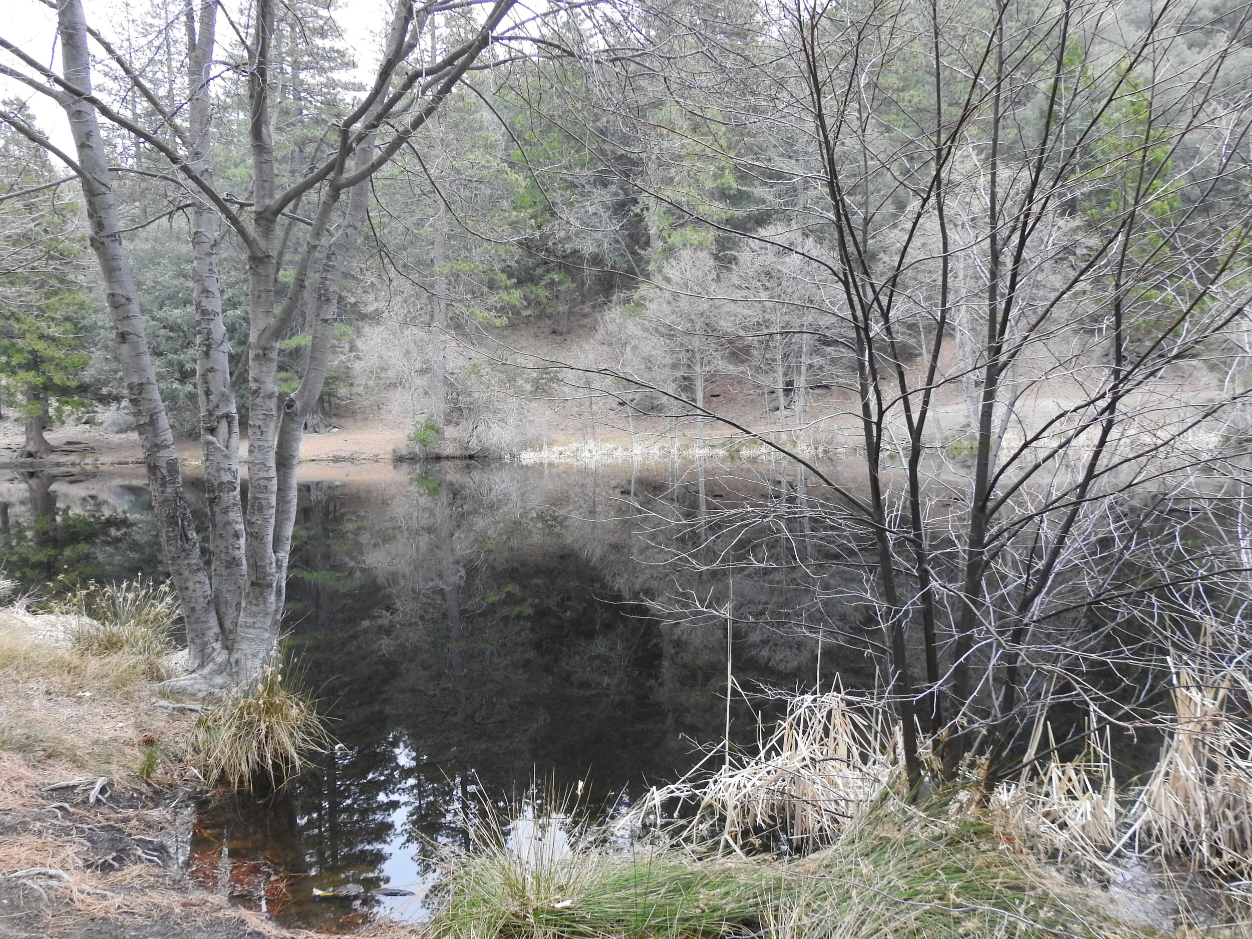
It was a beautiful Sunday to spend a night in Idyllwild. As we drove up the 243 early Sunday morning, the fog hung heavy over the mountain. Our first stop was Lake Fulmor where I did a little bird watching. This was a much different experience then when we were here on New Year’s day. On that day we couldn’t even get near the lake because there were so many people. This time we had the whole place to ourselves, and it was wonderful! It was so quiet and the fog rolling over the lake was eerily beautiful. I saw a beautiful Red-wing Blackbirds singing in the cattails; a new species to add to my life list! After about an hour or more enjoying the lake, we headed to the Ranger Station to drop off our permit for the Deer Springs Trail. My husband brought along his video camera, and I had both my Nikon birding camera and my Lumix. We took our time and mostly played around with the cameras taking photos and video and not worrying too much about covering any set amount of mileage. The forecast was calling for rain turning into snow later in the afternoon/evening, so we had to keep an eye on the weather. When we reached the junction for Suicide Rock it was clouding up quite a bit, but we decided to push on since it was only one more mile. The forest was very quiet and as we approached Suicide Rock, we started to see some light snow flurries. The clouds were thickening and looming over the mountain and the sky was turning darker and gray. It was so pretty and so peaceful. As we hiked down we passed through a couple of light hail storms. It wasn’t a long hike back — only about four miles. I was thoroughly enjoying the mountain weather and the peace and quiet of the wilderness. We got back to the trailhead around 4:30 pm. By that time I was tired and I was looking forwards to a nice, warm dinner and spending the night by a cozy fire back at our cabin in Idyllwild. It was a beautiful hike. I love it when the weather is gray and chilly. After dinner we snuggled up by the fire and fell asleep. I kept waking up every once in a while to look out the window to see if it had started to snow. The wind was blowing strong and I could see the pine trees being rocked back and forth. It was nice to be snuggled up in a nice warm cabin and I enjoyed listening to the wind in the trees. The next morning there was a light dusting of snow on the car. We got the fireplace going and my husband went to pick up some breakfast while I waited inside. It was snowing and hailing off and on all morning. We enjoyed the lovely fire, a delicious pancake breakfast and the warmth of the cabin before heading back to Los Angeles.

Read More

Snowshoeing on Mt. San Jacinto, 4.6 Miles RT, Max Elevation 9,229', 961' +/-, February 8, 2019

Snowshoeing on Mt. San Jacinto, 4.6 Miles RT, Max Elevation 9,229',  961' +/-, February 8, 2019

The mountains are filled with snow! I wanted to take advantage of it while I could sans the crowds of people I knew would be heading up over the weekend. I took the day off on Friday and my husband and I drove to Palm Springs where we took the Aerial Tramway to Long Valley Station to go snowshoeing. We loved it so much the first time we went a few weeks ago, that we purchased our own snowshoes. There was over three feet of snow on top of the mountain and the conditions for snowshoes were excellent. We spoke with the rangers as we filled out our permit before taking off into the wilderness, and they advised to not go any further than Round Valley due to the potential of avalanche. I’d originally planned to go to Wellmans Divide, but since the rangers know these mountains a lot better then we do, we of course, took their advice. The weather was fantastic! It was a bluebird day with not a cloud in the sky. The fresh mountain air felt great and the snow was fresh powder most of the way. We took our time and savored the journey soaking in the beautiful winter scenery. These are the moments I live for! It seemed we reached Round Valley much faster this time. We ventured into the meadow floating atop three feet of powdery snow and breaking trail. It was my favorite part of the day. Just glorious! All too soon it was time to start heading back. We were about a half a mile from Long Valley when my husband’s snowshoe broke. Somehow the rivets popped out and he was left with just the crampon strapped to his left foot. Luckily, we were not too far away from the trailhead, and he was able to hike back without a problem. Lesson learned -- Always carry a field repair kit. Although we both had microspikes with us, they wouldn’t have been very useful with the depth of the snow. Aside from that minor mishap, it was peaceful day to be out on the trails. I left the big mountain with a feeling of gratitude; so happy to have been able to enjoy another perfect day in this beautiful wilderness!

Read More

Santa Anita Canyon, Chantry Flat, Gabrielino Trail, Sturtevant Falls, Sturtevant Camp, Mount Zion, Winter Creek Trail, 8 miles RT, 2,336 +/-, December 1, 2017

Santa Anita Canyon, Chantry Flat, Gabrielino Trail, Sturtevant Falls, Sturtevant Camp, Mount Zion, Winter Creek Trail, 8 miles RT, 2,336 +/-, December 1, 2017

Today was an epic day full of history!  We arrived at the locked gate at Chantry Flat Road about 10 minutes ‘til 6 just before the sheriff arrived to open it.  We then drove up the windy road to the parking area at Chantry Flats, displayed our Adventure Pass and off we went into the Big Santa Anita Canyon.  This place was beautiful!  I immediately forgot I was only 25 minutes from our house in the city; towering oaks, a village of rustic cabins along a creek and lush, green ivy cascading the canyon walls.  We trekked creekside along the Gabrielino Trail enjoying the scenery before we reached Fiddler’s Crossing where we followed a short spur trail to Sturtevant Falls.  We then backtracked to the Lower Gabrielino trail and traveled onward and upward towards Sturtevant Camp.  The Lower Gabrielino trail took us up above the falls which was pretty cool since I’d never actually been on top of a waterfall before.  But be warned, the trail here is mostly jagged rock cut into the canyon wall, and there was one section in particular where it got a little sketchy due to erosion from the rains.  Besides that section, the rest of the trip is on a lovely, well maintained path.  Next, we headed up towards Spruce Grove camp and picked up the Sturtevant Trail to the historic Sturtevant Camp, established in 1893.  When we arrived, Brad, the host, greeted us welcomingly.  We chatted with him for quite a while and he showed us around the buildings which date back to “The Great Hiking Era”.  He also gave us a little history about the place and showed us inside the Sturtevant Lodge which has a kitchen, a dining hall and a fireplace room with an old piano.  On the walls, you can see photos of Mr. Wilbur Sturtevent himself.  At the turn of the century there were five resorts built here.  Sturtevant Camp is the only one that remains, and it’s still functioning!  You can rent the cabins, but there is no wifi, cell phone service, computers or TV, and your things will have to be brought up by mules from Adam’s Pack Station.  How cool is that!  For more information, you can check out this link:  http://sturtevantcamp.com/  After leaving camp, we got back on the Sturtevant Trail to the Upper Zion trail which took us to the spur for Mount Zion.  In just a short climb we were at the summit looking back at Mount Wilson.  After enjoying the view, we headed down and continued on the Upper Zion trail.  This section didn’t have much shade and the switchbacks were steep.  I was glad we were going down and not up!  Eventually, the trail dropped us back into the cool, shady canyon passing through Hoegee’s camp and onto the Winter Creek Trail before reaching our car parked at Chantry Flats.  We ended our adventure with ice cream from Adam’s Pack Station General store.  I would have loved to have seen the mules, but they were busy working today and making a delivery to Sturtevant Camp.  This was a really great hike with a little bit of everything; beautiful scenery, a waterfall, unique history and even a peak.  We will definitely take this route again through Sturtevant Camp when we hike to Mount Wilson!

Read More

Cucamonga Peak, 8,859', 12 miles RT, (4,252' +/-), November 23, 2017

Cucamonga Peak, 8,859', 12 miles RT, (4,252' +/-), November 23, 2017

Hit the trail early Thanksgiving morning to hike Cucamonga Peak.  We started up Icehouse Canyon at 5:30 am.  This was our third time up this trail to Icehouse Saddle which is a gateway to other trails including Cucamonga Peak.  It used to be a challenge, but it’s getting easier every time.  We entered the Cucamonga Wilderness just before the sun came up, and by 8 am we were at Icehouse Saddle.  We stopped for a snack, and it wasn’t long before other hikers arrived.  One of them was heading to the same destination as we were.  He was using the trail to train for other peaks.  After the break, we hopped on the next segment to Cucamonga Peak.  This is where the real hike began.  From here on out we were on much more rugged terrain with narrow sections, steep cliffs and rock scrambles.  It was one of those hikes where you really had to watch your footing.  Next came the switchbacks.  Some sections were all scree and talus.  It was a hard climb and my fear of heights being on a narrow ledge with loose rock and steep drops was starting to kick in.  I had to stop and take breaks to keep my zen.  I could see the peak, but it seemed a million miles away.  Up and up we went moving slowly, but making progress with each careful step.  We were less then half a mile away from the peak when we saw the young hiker we’d met at Icehouse Saddle coming down.  “Almost there.” he said.  “Take short steps and use your poles.”  After a few more switchbacks I spotted the marker for the spur trail leading up to the peak just ahead.  What a relief!  We made our final ascent up a steep but well buffed out section of trail.  Finally I saw the wooden sign, “Cucamonga Peak 8,859’”.  Whew!  That was rough!  The views from the peak were vast and sprawling overlooking the city and all the way out to the San Jacinto and Santa Ana mountain ranges.  We took a long break to rest our tired legs and celebrate Thanksgiving morning with yesterday’s leftover pizza!  On the way down my overactive mind calmed down.  Although I still had to be careful with my footing, I was in a much better headspace.  The hard part was over.  I was able to soak in the incredible views of the remote wilderness and enjoy the trek down this beautiful mountain.  The switchbacks seemed to go a lot faster on the way down, but we still had to negotiate our way through rugged trail back to Icehouse Saddle.  Once at the saddle, we still had about 3 miles to go to get back to the trailhead.  Luckily, the canyon is so pretty, it makes those last miles go quick.  We finished the hike (including our breaks and all my picture taking) in about 8 hours and 50 minutes.  We’ll be celebrating Thanksgiving day on Friday knowing we earned those extra slices of pumpkin pie!

Read More

Solstice Canyon: Rising Sun Trail to Solstice Canyon Falls to Sostomo Trail to Deer Valley Loop to Solstice Canyon Trail, gain 1,100 ft. Approx. 7 miles RT, August 6, 2017

Solstice Canyon: Rising Sun Trail to Solstice Canyon Falls to Sostomo Trail to Deer Valley Loop to Solstice Canyon Trail, gain 1,100 ft. Approx. 7 miles RT, August 6, 2017

So far our summer hikes have been at the higher elevations where it’s usually cooler.  But this weekend we opted to head towards Malibu and explore Solstice Canyon.  I knew this was a popular spot with some of the trails being on exposed hills, so we got there early before the crowds and the heat.

We arrived just before 7 am and there was still plenty of parking.  Our options were to head straight to the falls via the Solstice Canyon Trail, an easy walk down a paved fire road, or to head up the stairs to the right and take the Rising Sun Trail which climbs upward on more rugged terrain.  We opted for the later.  Just a few feet in we were already getting some nice views of the pacific.  The morning light was gorgeous and it reflected a beautiful golden hue on the summer wildflowers along the trail.  It was still early in the morning, but the exposed hills had us working up a good sweat.  As we reached the crest, the first view of what remains of Tropical Terrace mansion became visible down in the canyon. This mansion was built in the 1950s, but it burned down in 1982 in a wildfire. As we began to descend down into the canyon towards the ruins, we could hear the waterfall and the vegetation became noticeably greener.  

We spent some time exploring Tropical Terrace and the small but very pretty Solstice Canyon waterfall.  Afterwards, we walked south along the paved Solstice Canyon trail for a quick minute to pick up the Sostomo Trail.  The Sostomo Trail took us straight up on a less maintained more difficult trail to some very pretty views of the whole canyon and the pacific ocean.  We passed the ruins of a few more cabins along the way, dropped down in the the canyon and rock hopped over the creek a few times and eventually reached the junction of the Deer Valley Loop.  The Deer Valley Loop took us up even higher where we were able to get a birdseye view of Point Dume.  There were some parts of the loop that leveled off and opened up to meadows full of golden wildflowers and also beautiful Oaks.  This area was covered in white butterflies.  I believe they were Cabbage Whites, but they kept us company almost our entire time on these two trails.  I should note some of the other butterflies I saw here which were Swallowtails, Skippers and Marine Blues.  

After finishing the loop, we met back up with the Sostomo Trail and headed back the way we came.  It was about 10:30 am and now the crowds were starting to arrive.  We passed a few sweaty hikers who asked us if the climb was worth it.  It was actually pretty hot by this time, so a few of them decided to turn back.  

Once back down, we finished the hike on the Solstice Canyon Trail. (I actually don’t have any photos from this part of the hike because when I was downloading the images, some of the files got corrupted.  Not sure what happened there, but thankfully the rest of the photos were fine.)  

Overall, I really enjoyed this hike and the change of scenery.  I would definitely like to come back and do this one in the spring when everything is green, as I’m sure it would be full of different species of butterflies and the hills would be even prettier.
 

Read More