Once again we are back home in Southern California. It is here that I feel more like myself. The mountains and desert terrain is what I know best, and to start our adventures, we chose one of our favorite trails, Waterman Mountain.
Waterman Mountain was named after Liz Waterman, the wife of Bob Waterman who explored the area in 1889 along with Commodore Ferry Switzer. The mountain was originally named “Lady Waterman Mountain” after Liz. Later, when the U.S. Geological Survey mapped the mountain, they removed the “Lady” and the mountain is referred to as “Waterman Mountain”.
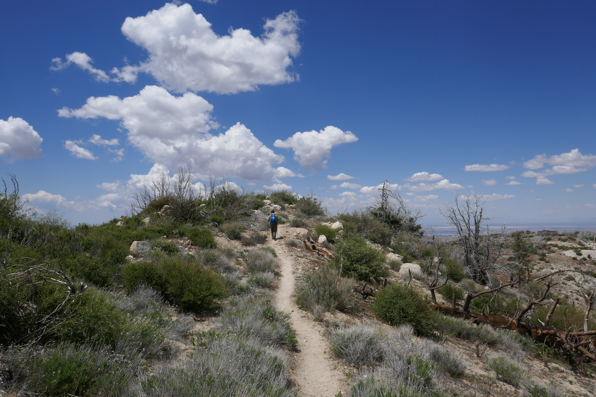
We took the trail from Buckhorn off the ACH climbing south through tall stands of Jeffrey Pine, Ponderosa Pine and Incense Cedars. This section took a hit from the Bobcat fire in 2020, and there are many charred trees, but the trail is still beautiful nonetheless. The vanilla smell of Jeffrey pines and dry sand along the trail was familiar and welcoming. I felt a sense of comfort. All worries and troubles from the past year were swept away on the fresh mountain air as we stepped onto the trail and began our climb. Once we reached the saddle on Waterman’s east ridge, we enjoyed the spectacular views down into Bear Canyon and out to Twin Peaks. Wildflowers were still blooming along the ridge. We took a short break before heading westward and up to the summit where we sat amongst the large rock formations and enjoyed our lunch. I reminisced how one year on New Year’s day we sipped champagne from the rocks and watched the stealth bomber fly over from the Pasadena Rose Parade. This mountain has always held special meaning to us and the San Gabriel High Country will always be one of my favorite sections of the Angeles.
Click “Read More” below to view more photos from this hike.
Headed up Josephine Peak today. With storms predicted, I wanted to get in a quick hike before we’d be stuck at sea level for a couple of days. If we get the amount of snow they’re calling for, CalTrans will have their work cut out for them. This next storm is supposed to be bigger than the one we had on Thanksgiving. If that’s the case, the next time we’re up here we’ll be donning the snow gear (and believe me, I can’t wait!). It was a perfect day for this hike. The clouds were rolling past Strawberry Peak making for great photography. The sun was in and out for most of the afternoon. As we wrapped around to the north, it got much cooler and the wind picked up slightly. There were plenty of ravens to watch as they put on their aerial displays, diving and twisting in the sky. They are fascinating birds to watch, and I’ve become enamored with them through the years. We didn’t see one other person on this hike today. I guess everyone is out Christmas shopping. As we headed back, the sun began to lower on the horizon and the clouds started to roll in and wrap around the mountain. Glad we got one in before the weather hits tomorrow!
It had been raining the past few days, but we got out for a bit on Thanksgiving to do rain hike in Griffith Park. But what I’d really been waiting for was to get up into the forest. The snow levels came down to about 3,000’! We headed up Angeles Crest around 8:30 am and started seeing snow just past Clear Creek Station. We went as far the 6,000’ Day Use Area (just before Winston Peak and Cloudburst Summit) which is where they had the snow gates closed. The road was clear until that point with just little patches of snow/ice here and there, and although we carried chains we didn’t need to use them. We parked the car, geared up in our snowshoes and got to climbing up the hill. There was no trail so we broke our own. We snowshoed up to a high point near John Henge rocks. Our elevation top out was 6,600’. It was a steep, but short climb and enough to give us a good work out. The snow was super deep. We were both in awe of seeing the forest covered in snow at such low elevations. We took in all in and thoroughly enjoyed this gift of an amazingly beautiful early snowfall. I hope this is a precursor of what’s to come this winter!
This weekend we did a hike up Pacifico Mountain. I love this hike. It’s a nice, long 13 mile day from Mill Creek, and in the summer the trail is full of wildflowers. I also enjoy this hike because I always see lots of ravens. They are such fascinating and intelligent birds. I love to watch them twisting and twirling as they play in the wind. On this day we got started a little late. We didn’t have time to cover all 13 miles, so we didn’t go all the way to the campground. When we first arrived the wind was gusting pretty hard, but it subsided as we got to hiking. As we climbed higher, we started to see snow on the trail left over from the rains we had the previous week. I imagine this will be the last time we hike this trail until the snow melts. Because this is a north facing mountain, the snow will hold for a long time. There’s another storm coming later in the week, and this one is supposed to bring a lot of snow down to the lower elevations. There is another route to the top on a fire road that you can take, but I’ve never tried hiking it. This could be an option for a future winter hike rather than the icy trail. As always, we had another fantastic day in the mountains!
It was a great day to take in some Fall color. We headed up to Wrightwood to hike along the Blue Ridge Trail where I knew the black oaks would be showing off some of their Autumn foliage. It was crisp and cool up in the mountains today, while back in Burbank it was almost 100 degrees!
This weekend we did a late afternoon/early evening hike up to San Gabriel Peak. It was a full moon and I wanted to watch the sunset from the forest and see the moon come up over the San Gabriels. We started the hike from Eaton Saddle and through the Mueller Tunnel. When we reached Markham Saddle, we took the trail towards San Gabriel Peak. I’d forgotten how steep and rugged it is. The views along the way were wonderful. We took a short break at the top, enjoyed the views and then started back down. The sun was beginning to set and it would soon be dark. When we arrived back at Eaton Saddle, we saw a HUGE harvest moon coming up over Mt. Baldy. It was such a beautiful site! It was a short, but sweet evening.
Got up before the sun to hike on the Trail Canyon Falls Trail. Not much water running at the waterfall since it’s the end of summer. Beautiful day for a short hike! Finished before the sun started to heat things up.
Every Sunday I wake up at the crack of dawn to hike. This past Sunday when my alarm went off at 5 am, my husband persuaded me to stay in bed. It was nice sleeping in for a change. Once we got up, we went out for breakfast then came home and relaxed until the afternoon. Around 2ish we headed up the ACH and into the Angeles National Forest to hike Waterman Mountain. We had our backpacking gear, and this time I was trying out a new Gregory backpack. My Osprey Kyte was bothering my shoulders, so I thought I should check into another pack. The Gregory seems to be a much better fit on my back. I was carrying around 27 lbs. We did approximately 7 miles taking the Waterman Trail up to the summit at 8,038’ feet and then heading back down on the fire road past the ski lifts to make a loop. We passed by the seasonal pond just below the summit. I’d never seen water in it before, but we’ve had so much snow this year that it looks like the pond may be around for a little while longer. Just as we were approaching the pond we saw a Search and Rescue chopper circling low. This was followed by a vehicle coming up the mountain with a team of rescuers. They showed us a photo and description of a hiker who’d gone missing on Saturday. They asked if we’d seen him, but unfortunately, we had not. We then continued our descent. The forest was quiet and the light was much different then I’m used to seeing it in the early morning. It felt very peaceful. The weekend crowd had cleared out and when we got back to the parking turnout, our car was the only one there. It was so nice I really didn’t want to leave! We got to see the sunset as we drove back on the ACH. It was a really nice afternoon. I think we need to do more late afternoon hikes in the future. It’s a nice change from waking up so early.
What a beautiful mountain. There are so many blooming wildflowers this time of year. We did this hike last year in June and the weather was very hot. This time the weather was still warm, but definitely not as bad. Again, just as last year, we saw very few people other then the PCT thru hikers passing by on their way to the Sierras. We put in quite a lot of mileage and the day was made even longer by my stopping to take photos every few minutes. The best hikes are always the ones where I take my time and don’t feel like I’m in a rush against the clock or in a big hurry to reach the summit. Now that we’ve been hiking for a few years and have hiked many of these mountains, I don’t feel such an urgency to summit and I’m taking more time to stop and really appreciate and enjoy the beauty of my surroundings. Even though Pacifico Mountain was hit hard in the 2009 Station Fire and there’s still a lot of visible damage along the route, it’s a very pretty hike. The area is incredibly beautiful with great vistas and it is full of flowers and wildlife. In fact, we can in very close proximity to a rattlesnake towards the end of the hike and only about a half a mile away from the trailhead. We didn’t see the snake, but we did hear the warning rattle. She must have been alongside the trail hidden where we couldn’t see her. It’s amazing how they can disguise themselves. As we climbed up the mountain, the trail changed from charred trees to beautiful Jeffery Pines. We had lunch at the campground on top of the summit. It would be so nice to camp here sometime. There were a good number of ravens circling and I saw several species of butterflies including painted ladies, swallowtails and duskywings. We spent good amount of time at the top before leaving. There was no one there but us. I scouted around the big boulders to see if I could find the official USGS marker, but I still couldn’t locate it. I’ll check again next time we’re here. It was a really nice day.
I had off on Friday and was looking for a challenge. Strawberry Peak seemed like a really good idea. We’d done this hike exactly one year ago, and I was excited to see if it would be easier this time since I’ve been working with a trainer for almost a year now at my gym and he’s been training me with my specific hiking and backpacking goals in mind. The hike starts out innocently enough meandering northeast from the trailhead at Red Box and making a sharp turn to the west and around the southern slope of Mt. Lawler until it reaches the saddle between Lawler and Strawberry. That’s where the fun begins. The trail then climbs unforgivingly for about the next mile and a half except for a short section where you’ll actually lose elevation and then have to climb back up later. I put my hiking poles away on the last mile so I could have free use of my hands for the rock scrambles. I felt really strong today and all the step ups I’ve been doing at the gym were really paying off!! I was definitely running on a bit of adrenaline and excitement, but I was having a good time. Strawberry Peak is still a butt kicker, but I could tell how much stronger I’ve become. We reached the top of the mountain in no time and since it was a week day, we didn’t see many other hikers and had the peak to ourselves. We signed the summit register, had lunch and then began our careful descent. On the way back we saw a lot of critters. One in particular was a Western Fence Lizard doing push ups to impress a female. We stopped to watch him as he tried to put the moves on her, but she had no interest. I wished him luck and continued down the trail. As we got closer to Red Box, we also saw a few snakes. They made their way into the shrubs as we passed by on the trail. It was an awesome day in the mountains!
I am really enjoying this snowshoeing thing! It was a beautiful day, so we decided to venture back into Angeles National Forest taking an alternative route around the recent rock slide on the ACH near Red Box and check out the conditions on Waterman Mountain. The ski lifts had recently been opened, so we knew there would be a good amount of snow. We past the lifts as skiers and snowboarders were just heading into the parking area and parked our car at the usual spot for the Mt. Waterman Trailhead. There was only one other car in the turnout when we arrived, and the air was chilly with an occasional gust of wind. We geared up (There’s a lot more to gear to deal with in winter.) and started up the Mt. Waterman Trail. At the junction with the Fire Road, we decided to head in that direction instead of our usual route. The snow conditions were mixed with sections of crusty ice on top of snow in the shade and a powdery mix in the sun. The snow was deep but packed and the fire road was a bit steep. We got a good workout as we enjoyed the views of snow capped Mt. Baden-Powell in the distance. We took our time and had the route mostly to ourselves. About two miles up we reached the junction with the ski runs. We stopped and watched some of the skiers and snowboarders do their thing. We could have continued on, but decided to take our time and head back. I thoroughly enjoyed every single second of another beautiful winter day!
My favorite part of the hike to Josephine Peak are the spectacular views. It’s a steady 4 mile climb to the peak, and today we had a nice, clear day since it had just rained. As we travelled up the fire road from Clear Creek Station just off Angeles Crest Highway, we could smell the eucalyptus trees and the yerba santa. It was even more fragrant today since it had just rained. I’m not quite sure how the eucalyptus trees got here since they’re not native, but they sure do smell nice. As we continued hiking up the trail, I started to get some great photo ops. Strawberry Peak looked quite impressive and we could see a dusting of snow covering the mountaineer’s route. We also had a nice, clear view of DTLA. The views went out all the way to the ocean. To the north, the high country was covered in fresh snow; Waterman, Baden-Powell, Twin Peaks, etc. As we neared the summit of Josephine, we crossed over a bit of snow ourselves. When we arrived at the peak, the views were even more incredible. The last time we were here we were shrouded in clouds so we didn’t get the 360 degree views that we had today. I took advantage and snapped away with my camera. It was absolutely lovely. After spending some time at the summit and greeting a few fellow hikers who’d come to enjoy the day as well, we decided it was time to begin our descent. The clouds started to roll in as we hiked back down the mountain, but we didn’t see any rain. It was an absolutely perfect day.
Our first hike of 2019 was to Mount Hillyer. I love this hike. There’s so much going on. Lots of great rock formations and change of scenery along the way. It was 39 degrees at Chilao where we picked up the Silver Moccasin Trail with wind gusts up to 50 mph expected at the summit. We had a great hike up. The breezy day was refreshing and there’s not much exposure on this trail with all the boulders, so we were protected from the wind for most of the route. There was a downed tree on the switchbacks of the Silver Moccasin trail. I’m not sure if it was caused by the winds, but luckily it was easy to maneuver over. As we continued our journey upward, the winds became stronger. My core was warm with all my layers, but for some dumb reason I didn’t wear a bottom base layer under my hiking pants. I don’t know where my head was this morning. I knew there would be a wind chill, and I’m usually the one who is over prepared with too much gear. When we reached the gusty summit, I could feel the tops of my legs getting numb. We hauled butt pretty quickly down off the exposed mountain top. I haven’t felt that numb feeling set in since Pennsylvania when I would spend the entire day at the barn riding and taking care of my horses in temperatures below zero some days! Once out of the big gusts, my legs warmed up and we continued our descent. About 1:30 pm, we heard a loud roar in the sky. As we looked up we saw two B-2 Spirit Stealth Bombers flying overhead. They were probably headed back to base after the Rose Parade. Last year we got to see one of them from the top of Waterman Mountain. I didn’t think we’d get to see that this year, but we actually got to see two of them! It was a great way to begin the New Year!
I love the hike to Devil’s Chair. We did it in October of 2017 and it’s a beautiful part of the San Gabriels hidden away to the far north. The geological formations that have been formed throughout the years by the San Andreas and Punchbowl Faults are an incredible spectacle to witness firsthand. This area is also a transition zone between high desert and subalpine, and it’s interesting to see how the plants change as you travel the undulating trail. This time it seemed the trail was a bit more eroded in sections then the last time we hiked it, but it was still easily passable without being unsafe. As we approached the Devil’s Chair we descended the switchbacks and navigated the over narrow, rocky cliffs. Thankfully, there’s a metal fence put in place here that allows you to go all the way out to the edge. Otherwise you would not be able to hike here. The views from the Chair were spectacular. Once we’d taken it all in, we climbed back up and had a quick snack break before starting our return. The clouds were starting to roll in and it looked pretty chilly up in the higher elevations on Pleasant View Ridge and Mt. Lewis. The temperature dropped to about 43 degrees as we made our way back and the wind kicked up making it a chilly end to a beautiful winter day.
Today we hiked the Gabrielino Trail East from Red Box to Valley Forge Trail Camp with the option to continue on to West Fork and Devore Trail Camps if we felt up to it. With the cool morning temperatures and the trail covered in falling leaves from the towering oaks that surrounded us, it was finally starting to feel like fall. The first part of the trail descended the steep stone steps from the Red Box picnic area then continued down some exposed switchbacks. It wasn’t long until we were in the cool shade of the oaks following the trail along the South Fork of the San Gabriel River. The stream was dry at this time of year, but that didn’t stop the gnats from bothering us. Luckily, we were prepared and always have our bug nets with us which prevented the pesky insects from flying into our eyes.
On our route we passed by some cabins and the ruins of an old, stone chimney. After about two miles, we reached the junction for the Valley Forge Trail Camp that was marked with a sign at the spur. We descended the spur to the camp to check it out and see if it was a place we’d like to stay as a future backpacking trip. The camp was lovely with plenty of shade, fire rings, picnic tables and primitive bathrooms. We set up at one of the picnic tables and decided to stay a while. I made friends with a Steller’s Jay who invited himself to our breakfast table. It was a very nice day and we were thoroughly enjoying the peace and quiet! This hike along this section of the Gabrielino Trail reminded me a bit of Santa Anita Canyon sans the crowds. We will definitely be coming back when the weather cools down a bit more to hike the longer routes to West Fork and Devore Trail Camps, and perhaps enjoy an overnight stay.
For my upcoming birthday I asked my husband for a Jetboil cooking system. It would be the first item in a long list of backpacking gear that we’re going to need to make the crossover from day hikers to backpackers. Since I’d been looking for an excuse to make the short hike up the little bump called Mt. Akawie (aka Buckhorn Peak if you’re using a Tom Harrison map), we headed up to the mountain to test the new cooking system and spend a quiet morning together.
We hit the trail just after 6 am. After a very short distance we took the path leading up to the peak. There appeared to be a number of fire roads around to explore, but we were ready to get cooking and I couldn’t wait for a hot cup of coffee. The Jetboil system did not disappoint! For breakfast I’d packed a couple of Eggo waffles (my favorite) and brought along a freeze dried breakfast scramble from Mountain House. Overall, it was pretty good. I definitely could live on this stuff for a couple of days in the backcountry. After eating, we got comfortable on one of the large, flat bounders looking towards Waterman Mountain and Twin Peaks and napped for a short while. After a peaceful rest and stomachs full of interesting freeze dried food, we packed up our gear and did some exploring around the mountain both on and off-trail. An unmaintained road/trail took us northeast around the bump and offered views looking towards Pleasant View Ridge. We also saw a lot of deer; mostly doe and one with a young fawn. The road/trail eventually disappeared and we made a scramble up the east side of the mountain before heading back the way we came. It was around 11 am when we got back to the car. We thanked Mount Akawie for the hospitality and headed home to enjoy what was left of our weekend.
We watched the sunrise from Cloudburst Summit as we geared up and got ready to hike to Winston Ridge and Winston Peak. We’d been to Winston Peak a few times before, but we had climbed it from the north side. This time our plan was to hike to Winston Ridge first (which we had not done) and then tackle the steep ascent up the use trail on the south side of the mountain to Winston Peak. We began the hike by descending the fire road and heading northwest on the PCT. When we reached a small saddle with Bump 6903 we had a choice to climb up and over the bump or hike around it to the left or to the right. From the research I’d done it seemed taking the use trail to the left was going to be our best option. The trail was quite rugged with soft dirt and loose rock that would give way if you weren’t careful. We had a number of downed trees to negotiate as well. There was one rather large tree that was particularly challenging. (I will talk more about that later.) This rugged section of trail tested our agility for sure, but it was definitely a lot of fun. When we reached another saddle, we continued northwest to reach the high point on the ridge. The hike along the ridge was undulating and lovely with views of Squaw Canyon to the south and Pleasant View ridge on the opposite side. We could also see the transition zone from forest to desert. We hiked past the high point on the ridge and came to a rock formation that reminded me of the back of a stegosaurus sticking out of the ground. I examined it looking for a way to get around it, but it looked a little sketchy, so I opted not to continue any further. We took a long break on the ridge and chatted about how nice it was to be the only ones here. For such a fun hike I was surprised it didn’t have more people on it. But being I like my solitude, I was not complaining. I explored some of the interesting rock formations and checked out the views in all directions while my husband made some contacts on his HAM radio. Before continuing the journey, we signed the summit register which was tucked away in some rocks marked by a rock cairn. We then started heading back enjoying the views and the scenery along the ridge. As we got closer to the saddle, I had a good perspective of that very large downed tree I’d mentioned earlier. We had climbed over it on the way to the ridge and it looked awfully menacing from this angle. When we reached the downed tree, my husband went over first (as we had done on the way to the ridge) so I could hand him my backpack making it easier for me to maneuver up and over. The footing here was loose, and we had to be extra careful. We continued along the slippery slope and at one point we diverted slightly off trail after negotiating another downed tree. We could see the saddle and Winston Peak right in front of us and were able to correct ourselves right away. Once back at the junction with the PCT, we had the choice of hiking back the way we came, or we could make the steep ascent up the south side of Winston Peak on a use trail. We decided to take on the challenge! The climb showed no mercy, but it sure was fun! The ground wasn’t nearly as slippery as what we’d experienced on the way to the ridge. I turned around to look back a few times to take in the wonderful views of Winston Ridge and snap some photos. This was also a good excuse to catch my breath. The climb seemed to go on and on, but I could see the top and I knew we’d be there in no time. Once at the top of Winston Peak, we gave each other a high five. We both felt pretty accomplished! I wandered around the summit for a while climbing about the rock formations and keeping an eye out for a summit register. I never did find one. We then descended down the north side of the mountain and back to Cloudburst Summit. I had actually wanted to include the short hike to Mount Akawie (aka Buckhorn Peak) on this trip, but both of us decided what we really wanted was a bacon cheeseburger and some fries! It was well earned after this climb!
Kratka Ridge has been on my radar to hike for quite some time. We made a plan this weekend to go check it out and when mapping out the route, I added nearby Peak 7160 to the plan. The whole hike was only a little over two miles, but in that short distance we were offered amazing views, a fun, steep climb and plenty of solitude. We arrived at the trailhead at the Vista Picnic Area around 6:30 am. The route wasted no time ascending quickly and offering great views. As we continued there were sections where the ground was soft and the footing was loose making the going more challenging. It wasn’t long before we reached the ruins of an old, wooden ski lift that had been in operation from the 1950s up until 2001. Now its deteriorating structure sits abandoned with single seat ski lift chairs hanging from the cables. We spent some time exploring the structure and tried to imagine what it had been like when it was up and running. We sat inside the old ruins looking down the mountain towards the rickety lift chairs enjoying each other’s company and the quiet of the morning until it was time to continue up to the high point on Kratka ridge. Behind the ski lift I discovered what looked to be a use trail that would require some scrambling up rocks and tree roots to reach the top. I continued to explore the area looking for the best way up and just a little further past the wooden structure I found another use trail on the side of the slope that would also take us to the top. The trail was narrow and a bit loose, but I felt comfortable enough to negotiate it to reach the high point from this route. At the top of Kratka Ridge we were rewarded with some of the most excellent views of Bear Creek Canyon and the San Gabriel Wilderness I have ever seen. I could identify Mount Williamson, Waterman Mountain, Twin Peaks and many of the other surrounding mountains from the viewpoint. After we were done taking it all in, we found another faint trail which followed the wilderness boundary. I figured it would take us back to the scramble behind the lift and sure enough it did. We then began our descent down the mountain being extra careful on the slippery sections. As we descended I could see Peak 7160 right in front of us. There wasn’t much of an established way up, so we started heading towards its high point. The ascent was steep, but the footing was fine. Along the way I found a heart that someone had made out of pine cones. When we reached the summit, I found another one made out of stones. So cute! From Peak 7160 we had a great view looking back over at Kratka ridge and down into the canyon. It was a lovely day. Although it was short, this hike is definitely a favorite!
This weekend we had a fun field day practicing our basic navigation skills with a good o’le map and compass. We recently had taken a class at REI and wanted to practice what we learned in the field. We decided to hike to the West Ridge of Waterman Mountain. This would give us a chance to do some minor cross country route finding on an unestablished trail. We started the hike at Angeles Crest mile marker 54.10. We followed the road to a fork in the trail and headed southeast. The trail is wide at first and easy to follow. Eventually, we came to a junction with a watercourse and a very faint use trail that would fade in and out as we made the steep climb up to the wilderness boundary on the ridge. It was a nice challenge and we completed the task successfully! After making our way carefully down the slope and back to the parking area, we decided to drive to the nearby Winston Peak and climb to it’s high point where we could see the surrounding mountains and use them as landmarks to practice triangulation. The hike up to Winston Peak is steep, but short. From the top we could see Will Thrall, Pallet Mountain, Mount Baden-Powell and Cucamonga Peak to name a few. It was a great spot to put these basic navigation skills to good use. In this day of modern technology, we have so many fancy electronic gadgets readily at our disposal. But it’s always good to go back to basics and also an extremely valuable skill to have. It was another fun day in the mountains!
I’m always looking to escape weekend crowds and find new trails to explore. This Sunday our hike was to the top of Mount Pacifico in the northern part of Angeles National Forest. We planned to start the hike at Mill Creek and follow the PCT which runs through this area. It looked like the trek would be around 12 to 14 miles depending on whether or not we did an out and back on the PCT or did a loop. The day was going to be hot, but I figured since we were heading up to a higher elevation, it might not be so bad on the ascent. If it got too hot, we would descend and save it for another time. The trail was very beautiful. There were many wildflowers and so much ceanothus (California lilac) which made for a very pleasant fragrance along the way. There was lots of wildlife activity too; squirrels, chipmunks, songbirds, bees, insects and butterflies. As we climbed higher, we started to see beautiful, tall pine trees. Much of the area was burned in the 2009 Station Fire, and we could see the effects of that as we hiked this route. But the area looks as though it’s been recovering nicely. Eventually, we reached a junction where we left the PCT and headed southeast to a jeep road that took us up to the summit. There are outstanding views of the surrounding mountain ranges along the way making the road more interesting. After about a mile or so we reached the summit. Mount Pacifico Campground is also here. There are picnic tables, a fire ring and vault toilets. That’s quite a luxury to have up on a summit! There are also a lot of very interesting rock formations to explore. There wasn’t anyone here today, so we took a good long rest and relaxed and enjoyed the peace and quiet. Soon it was time to head back and get ready for the heat as we descended to a lower elevation. We opted to come back the way we came on the PCT for a more scenic and enjoyable route. Both of us had been keeping well hydrated throughout the trip and we had no problems with it being so warm. We were even gifted with an occasional breeze as we hiked back down the mountain. I found this trail to be very nicely graded so although it was long, it was very pleasant. A very enjoyable hike!