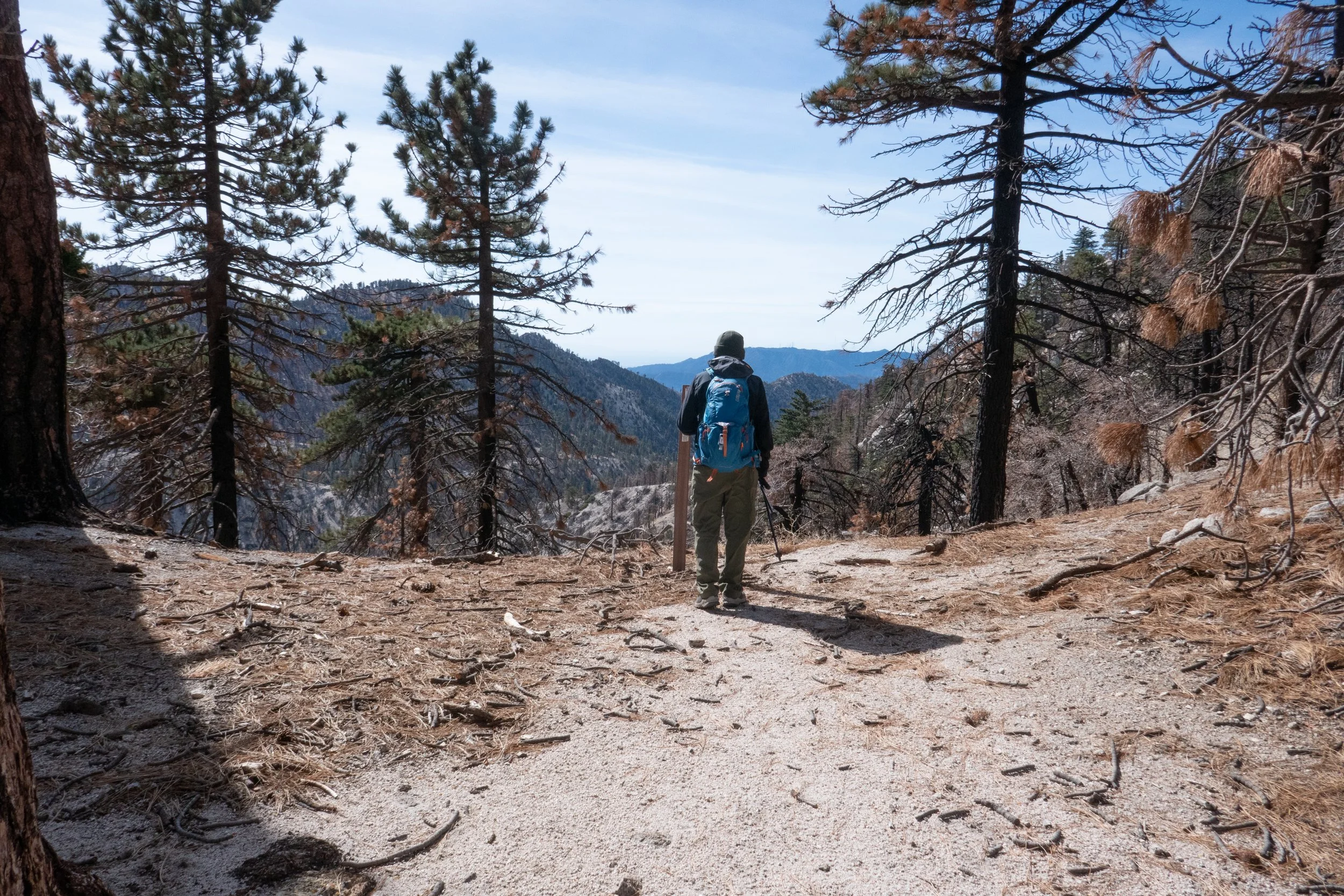
Being back in the mountains of California was the most incredible feeling of coming home. The evening we arrived we walked the hills of Griffith Park overlooking the city lights of Los Angeles. I really can’t describe how happy and at peace I finally felt after being out of sorts on the east coast for the past couple of years. The next morning we drove up the crest into the ANF. I’d not forgotten anything about the highway with its twisting turns, steep drop offs and views of the mountain peaks. I could still point them out. I guess they are not so easily forgotten after spending so much time on top of them. It was a beautiful morning and our plan was to return to Waterman Mountain, a mountain we’d climbed many times, snowshoed in the winter and even spent a New Year’s morning on the summit sipping champagne waiting to see the stealth bomber flyover after it opened the Pasadena Rose parade. We parked the jeep and hit the trail in the cool air and warm sunshine. Immediately I was gifted with the familiar vanilla scent of Jeffrey pine. It almost brought me to tears, only reinforcing that I was truly home. As we made our way up the trail, I noticed the damage that had been done by the Bobcat fire which happened just shortly after we left California in 2020. The trees were charred, but surprisingly the trail was in good shape and still beautiful nonetheless. I thought of all the firemen who put their lives on the line to save this beautiful land. We took our time hiking up the trail through the great conifers and rock formations. I wanted to savor every single moment of this trail. Upon reaching the junction for Twin Peaks and the summit to the top of Waterman, we stopped and sat on the rocks as we’d done so many times before. The quiet forest and sound of the mountain breeze whispering in the trees reminded me that this is where I belong. I felt grounded, centered and at peace. Like a huge weight had been lifted and carried away on the wind. When we were ready, we climbed the rest of the way up to the summit where we sat, had a snack and gave an offering to the forest, thanking it for always being here and taking us in. I had so much gratitude in my heart. We were back! Ready for more adventure!
Got up before the sun to hike on the Trail Canyon Falls Trail. Not much water running at the waterfall since it’s the end of summer. Beautiful day for a short hike! Finished before the sun started to heat things up.
We got up late today and decided to take our time getting anywhere. We weren’t really decided upon any one hike, so I stuffed my backpack with maps, downloaded a bunch of different trails onto the Garmin and headed up the ACH. The rock slide still hasn’t been repaired, so we had to take the detour to get to the high country. We then decided today would be a good day to hike Devil’s Canyon. The weather was cool, and I remembered last year when we did this hike in April there was lots of water flowing. I knew with all the rain and snow this year, there would be plenty of water now too. The trail hadn’t changed much. The views down into the canyon overlooking the San Gabriel Wilderness were beautiful. The trail could definitely use some love though. It was pretty brushy in some areas, and there were some trees down across the trail. There was also more erosion. Still, it was nothing too difficult to get around. We followed the creek most of the way and eventually reached the backcountry campsite. We saw a family on their way out who had spent the night. They had their kids who were carrying backpacks bigger then they were and two dogs. I asked them how their night was, and they told me it rained all night. We made our way over to this really great rock I found last year right next to the stream. It’s nice and smooth and shaped like a recliner. We got comfortable and ate our lunch (ham and cheese croissants from the donut shop... yum!). The sound of the running water was so relaxing and the clouds were billowing across blue sky. We took a nice nap until eventually the sky turned to gray and the sun was covered by the clouds. We packed up our stuff and began the hike up out of the canyon. I took a lot of photos on the way back. There were lots of wildflowers, and at one of the creek crossings there was a ton of ladybugs (and also poison oak). The cloud cover made the hike up and out pleasant since it kept us cool on the exposed sections of the trail. It was a very peaceful, relaxing day.
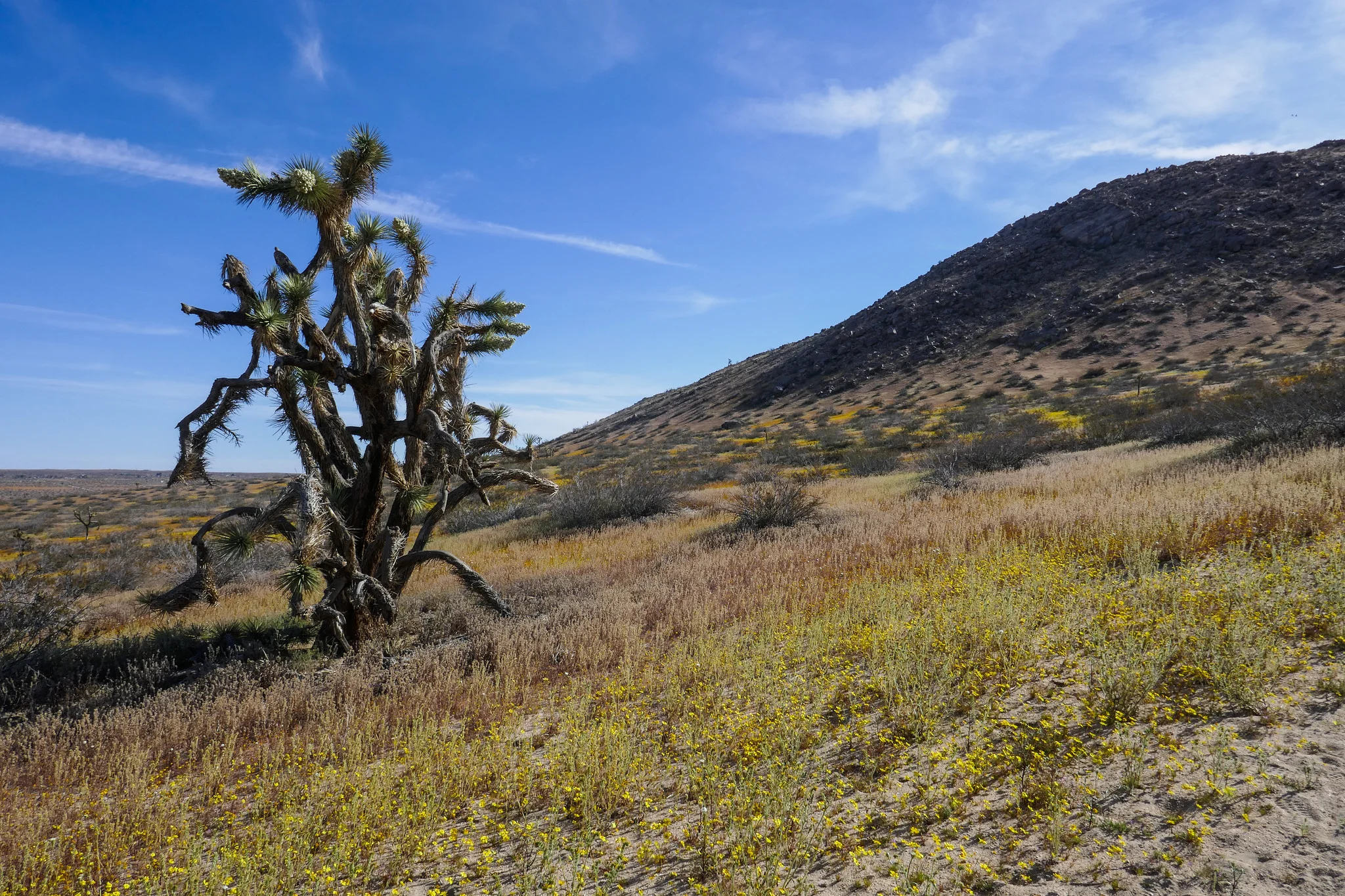
We hiked Little Butte and Saddleback Butte this weekend. I was here last year, but had not gone during the wildflower bloom. It was magical! We started our hike on the Dowen Nature Trail which connects to the Little Butte Trail and eventually the trail leading up to the top of Saddleback Butte at 3,651’. I immediately began to see carpets of wildflowers blanketing the park and the Fiddleneck flowers were covered in thousands of caterpillars. We took our time and admired all the beauty being offered to us here at the western edge of the Mojave Desert. I took note of some of the many wildflowers we observed. We saw: Coreopsis, Fiddleneck, Desert dandelion, Sun cups, Desert candles, Davy gilia, Fremont pincushions, Dune primrose, Wild Rhubarb and in addition, the Joshua Trees were in full bloom. Eventually, the sandy trail gave way to rocky terrain as it began its steep ascent up the top of Saddleback Butte. The wind was strong as we climbed and after a few easy rock scrambles, we were at the top enjoying the 360 degree views. To the south we could see the snow capped San Gabriel Mountains and further off in the distance we could make out Mt. San Gorgonio and Mt. San Jacinto. This was a really wonderful hike and being able to see the park in all it’s wildflower glory was a special treat!
Sunday was our first hike in about a month since my husband and I were busy moving most of November. Late Sunday morning we headed up Angeles Crest Highway with a bunch of maps, but no real commitment to any particular trail. As we passed by the entrance to Switzer Camp the overflow parking along the highway didn’t look too busy. We turned in and headed down to see how it was looking. Surprisingly, it wasn’t too packed for a weekend. Some of the oaks were still holding onto their color, so it was a nice treat since we didn’t get to experience much of the fall weather this year. The stroll along the Arroyo Seco was very pleasant, and we crossed the stream a number of times. I think the last time we hiked this all the way to Bear Canyon Trail Camp last March, I counted a total of 50-something crossings round trip. It was a beautiful day. Perfect hiking weather; a little chilly to start, but we warmed up as we kept going. On the cliffs we passed by the ruins of the old Switzer-land chapel and then descended down towards Switzer Falls. We decided to forgo the falls this time and continue on to the Bear Canyon Trail knowing there’d be lots of pretty cascades along the way and a lot less traffic. We hiked in as far as the junction where the two streams intersect, and then continued on a bit farther to where the going becomes less maintained. We stopped about a mile short of the campground this time. It was getting later in the day and we wanted to make sure we got back before the sun started to set. It was a nice way to ease back into the hiking routine again, and we could not have asked for a more perfect day.
The best time for hiking during the hot summer months is EARLY! I like to be on the trail either before sunrise or shortly after so I can enjoy my time on the trail before the day heats up. This is also the time of year when I like to stick to the high country or look for higher elevation hikes which are usually a bit cooler than those at the lower altitudes. Mount Williamson was the perfect hike for today; a short 5 miles from the Islip Saddle trailhead with a little bit of an elevation gain and a fun climb. The early morning sunlight was brilliant as we headed up the trail which starts off on the PCT. It wasn’t long before views of Mount Islip opened up to the south on the opposite side of the Angeles Crest Highway. The hike to Mount Williamson is a fun one. We did this last year in September and I really enjoyed it. The climb is mostly steady until you get closer to the top where you leave the PCT and the trail to Mt. Williamson becomes quite steep and rugged. Once at the top we had wonderful 360 degree views. It was only us on the summit so we took our time, had some snacks and after orienting my map, I spread it out and secured it with some rocks so I could use it to identify some of the surrounding features of the area. Many of the surrounding peaks were visible including Mount Lewis, Mount Baden-Powell, Throop Peak, Mount Hawkins and Twin Peaks to name a few. To the north I could see all the way out to the Mojave Desert and to the southwest I had a nice view of Williamson Rock, which was once popular with rock climbers until the area was closed off to protect the mountain yellow-legged frog. It was barley 9 am and already I could feel the sun starting to heat up the day, so we headed back enjoying our time on the trail and the sweet, vanilla fragrance of the Jeffery pines along the way.
I’m always looking to escape weekend crowds and find new trails to explore. This Sunday our hike was to the top of Mount Pacifico in the northern part of Angeles National Forest. We planned to start the hike at Mill Creek and follow the PCT which runs through this area. It looked like the trek would be around 12 to 14 miles depending on whether or not we did an out and back on the PCT or did a loop. The day was going to be hot, but I figured since we were heading up to a higher elevation, it might not be so bad on the ascent. If it got too hot, we would descend and save it for another time. The trail was very beautiful. There were many wildflowers and so much ceanothus (California lilac) which made for a very pleasant fragrance along the way. There was lots of wildlife activity too; squirrels, chipmunks, songbirds, bees, insects and butterflies. As we climbed higher, we started to see beautiful, tall pine trees. Much of the area was burned in the 2009 Station Fire, and we could see the effects of that as we hiked this route. But the area looks as though it’s been recovering nicely. Eventually, we reached a junction where we left the PCT and headed southeast to a jeep road that took us up to the summit. There are outstanding views of the surrounding mountain ranges along the way making the road more interesting. After about a mile or so we reached the summit. Mount Pacifico Campground is also here. There are picnic tables, a fire ring and vault toilets. That’s quite a luxury to have up on a summit! There are also a lot of very interesting rock formations to explore. There wasn’t anyone here today, so we took a good long rest and relaxed and enjoyed the peace and quiet. Soon it was time to head back and get ready for the heat as we descended to a lower elevation. We opted to come back the way we came on the PCT for a more scenic and enjoyable route. Both of us had been keeping well hydrated throughout the trip and we had no problems with it being so warm. We were even gifted with an occasional breeze as we hiked back down the mountain. I found this trail to be very nicely graded so although it was long, it was very pleasant. A very enjoyable hike!
This hike is another one that had been on my bucket list. I can see Mount Wilson from my back porch, and we’d only ever visited it once in 2011 when we drove there. I was very excited to try and hike it! We did a loop trail starting from Chantry Flat then up over Sturtevant Falls on the Lower Gabrielino Trail passing through Sturtevant Camp and then finally the Sturtevant Trail to Mount Wilson. The Observatory itself is worth spending a whole day exploring if you have the time. On the way down we took the Mount Wilson Trail to Mount Wilson Toll Road, back onto Mount Wilson Trail to Winter Creek Trail to Lower Winter Creek Trail and back to Chantry Flat. I really enjoyed this hike and although it’s a long one, I didn’t find it particularly difficult. Most of the time you’re hiking through shaded forest, and the Lower Winter Creek Trail is exceptionally pretty. My legs were tired at the end of the hike, but the scenery was worth the effort. We’ll have to do this one again sometime when the Cosmic Cafe is open so we can get ice cream cones at the top!
Our Christmas Day was spent hiking a section of the Pacific Crest Trail from Inspiration Point to Vincent Gap. The air was calm but crisp and scented with my favorite vanilla Jeffery Pines. The trek along this stretch of the PCT is mostly evenly graded and under the shade of pine trees until you drop down into Vincent Gap where you’ll lose about 1,000’ of elevation in less then a mile. If you do this trail, just remember to leave some extra gas in the tank for the climb back up later. Beautiful pine needles cover much of the path along the way and just before Vincent Gap you’ll pass through a flat section where there’s a pine grove. As the trail begins to descend the scenery then changes into a scene from Snow White’s forest and you’re suddenly in a fairytale forest of oak trees. We hiked almost 10 miles round trip stopping at Jackson Flat campground to have lunch. I can’t think of a better way to have spent our Christmas this year then on the trail in these beautiful mountains!
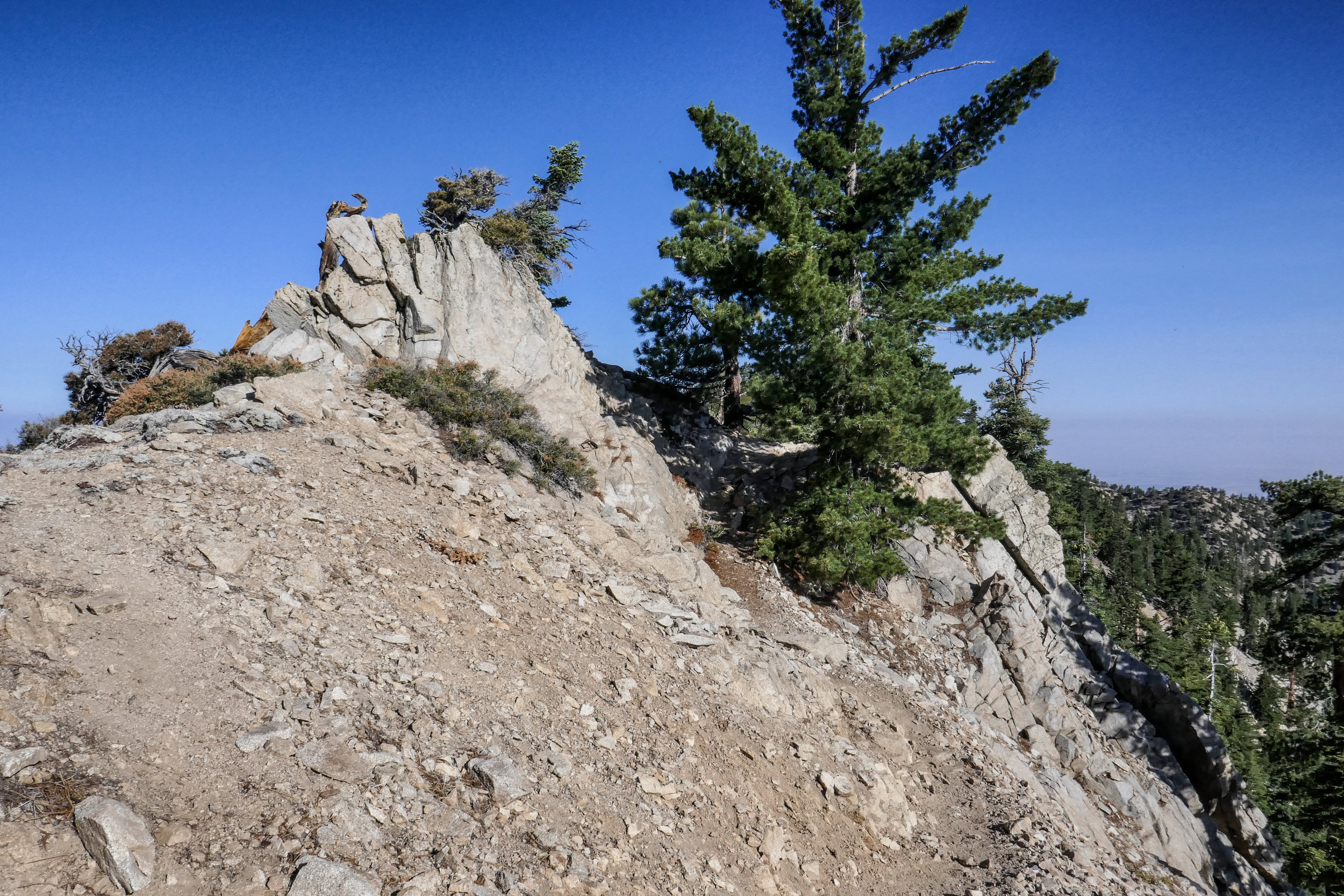
Hit the trail early Thanksgiving morning to hike Cucamonga Peak. We started up Icehouse Canyon at 5:30 am. This was our third time up this trail to Icehouse Saddle which is a gateway to other trails including Cucamonga Peak. It used to be a challenge, but it’s getting easier every time. We entered the Cucamonga Wilderness just before the sun came up, and by 8 am we were at Icehouse Saddle. We stopped for a snack, and it wasn’t long before other hikers arrived. One of them was heading to the same destination as we were. He was using the trail to train for other peaks. After the break, we hopped on the next segment to Cucamonga Peak. This is where the real hike began. From here on out we were on much more rugged terrain with narrow sections, steep cliffs and rock scrambles. It was one of those hikes where you really had to watch your footing. Next came the switchbacks. Some sections were all scree and talus. It was a hard climb and my fear of heights being on a narrow ledge with loose rock and steep drops was starting to kick in. I had to stop and take breaks to keep my zen. I could see the peak, but it seemed a million miles away. Up and up we went moving slowly, but making progress with each careful step. We were less then half a mile away from the peak when we saw the young hiker we’d met at Icehouse Saddle coming down. “Almost there.” he said. “Take short steps and use your poles.” After a few more switchbacks I spotted the marker for the spur trail leading up to the peak just ahead. What a relief! We made our final ascent up a steep but well buffed out section of trail. Finally I saw the wooden sign, “Cucamonga Peak 8,859’”. Whew! That was rough! The views from the peak were vast and sprawling overlooking the city and all the way out to the San Jacinto and Santa Ana mountain ranges. We took a long break to rest our tired legs and celebrate Thanksgiving morning with yesterday’s leftover pizza! On the way down my overactive mind calmed down. Although I still had to be careful with my footing, I was in a much better headspace. The hard part was over. I was able to soak in the incredible views of the remote wilderness and enjoy the trek down this beautiful mountain. The switchbacks seemed to go a lot faster on the way down, but we still had to negotiate our way through rugged trail back to Icehouse Saddle. Once at the saddle, we still had about 3 miles to go to get back to the trailhead. Luckily, the canyon is so pretty, it makes those last miles go quick. We finished the hike (including our breaks and all my picture taking) in about 8 hours and 50 minutes. We’ll be celebrating Thanksgiving day on Friday knowing we earned those extra slices of pumpkin pie!
This Sunday we left the unbearable heatwave looming over Los Angeles and headed to the higher altitude of the mountains in Wrightwood to hike the Acorn Trail and summit Wright Mountain. The Acorn Trail is a 2.1 mile trek with a 1,500’ elevation gain that leads to the junction of the PCT. It starts off on private property at the end of Acorn Drive in Wrightwood, so you’ll need to park your car before the private property sign (there’s a turn out just before the sign that fits two cars) and hike about 3/4 miles up the steep Acorn Drive. It’s a nice way to warm up those muscles and prep for the steady climb you’re about to take on. Once you get to the proper trail, it climbs steeply through a shaded forest of oak and pine. Some spots of the trail can be a bit precipitous, but no worries. Take your time and keep on trekking. At 2.1 miles you’ll reach a junction with the PCT. Turn left (head east) and follow it, but keep you eyes peeled for the use trail leading up to the summit of Wright Mountain. We missed this trail the first time because my original directions told me to hop on the Blue Ridge Truck Trail which parallels the PCT. The truck trail does not lead to the summit, but it still has some outstanding views of Pine Mountain, Mount San Antonio and the Sheep Mountain Wilderness. After we’d been walking for awhile with no indication that we’d be going up anytime soon, I pulled out the handy Tom Harrison map. It showed that the truck trail would soon end, and at that point we could just hop back on the PCT and head back west to where we came from. We were in no hurry, so we enjoyed the views and extra mileage. On the way back, we found our destination. Sure enough there was a use trail splitting off and leading to the summit of Wright Mountain. This ‘trail’ (if you could call it that) is not maintained. We had to bushwhack our way up through overgrown chaparral to get to the top which was actually a lot of fun. This is definitely not a trail to do in shorts! Just after we reached the top, the wind started kicking up and storm clouds started rolling in. We took in our views and began our descent. A light sprinkle began to fall and the forest became peaceful and still with only the sound and fragrance of fresh summer rain. We could not have timed it any better... Just as we got back to the car, the sky opened up and it poured! There's nothing quite as refreshing as a good mountain rain! It was a lovely day and as per our usual routine, we rewarded ourselves with a hearty lunch at the Grizzly Cafe in Wrightwood.