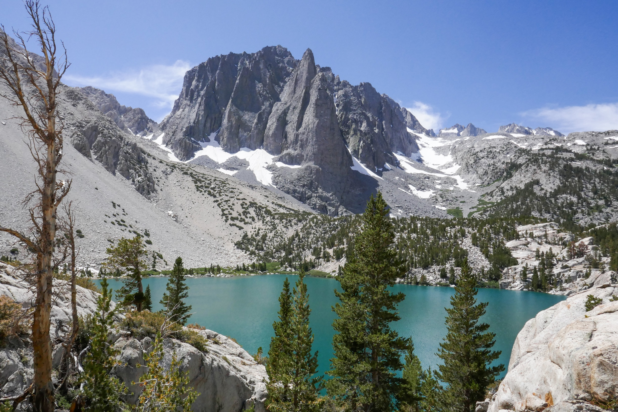
Our hike to Big Pine Lakes in the Eastern Sierra was one of the most beautiful hikes I’ve ever been on. There are seven lakes total and on this day, we hiked to the first three via the North Fork Trail. Since we weren’t backpacking, I had much less weight to carry then when we were in the Eastern Sierra last month backpacking the Mt. Whitney Trail. Most of the Big Pine Lakes hike follows along Big Pine Creek. We were next to the beautiful rushing waters most of the day. Early in the morning when we first got on the trail, we saw two doe and a fawn crossing the creek. There were plenty of wildflowers and butterflies to enjoy throughout the day as well. I took my time on this hike and spent a lot of time taking photos of it all. When we reached lake one we saw Temple Crag (popular with alpine rock climbers) towering over the incredible turquoise waters. The turquoise color comes from the glacial powder of Palisade Glacier. I also saw some trout swimming in the lake. This was a wonderful hike. We had to do some work climbing up in elevation to get to the lakes, but it was well worth the effort because the scenery was spectacular.
What a beautiful mountain. There are so many blooming wildflowers this time of year. We did this hike last year in June and the weather was very hot. This time the weather was still warm, but definitely not as bad. Again, just as last year, we saw very few people other then the PCT thru hikers passing by on their way to the Sierras. We put in quite a lot of mileage and the day was made even longer by my stopping to take photos every few minutes. The best hikes are always the ones where I take my time and don’t feel like I’m in a rush against the clock or in a big hurry to reach the summit. Now that we’ve been hiking for a few years and have hiked many of these mountains, I don’t feel such an urgency to summit and I’m taking more time to stop and really appreciate and enjoy the beauty of my surroundings. Even though Pacifico Mountain was hit hard in the 2009 Station Fire and there’s still a lot of visible damage along the route, it’s a very pretty hike. The area is incredibly beautiful with great vistas and it is full of flowers and wildlife. In fact, we can in very close proximity to a rattlesnake towards the end of the hike and only about a half a mile away from the trailhead. We didn’t see the snake, but we did hear the warning rattle. She must have been alongside the trail hidden where we couldn’t see her. It’s amazing how they can disguise themselves. As we climbed up the mountain, the trail changed from charred trees to beautiful Jeffery Pines. We had lunch at the campground on top of the summit. It would be so nice to camp here sometime. There were a good number of ravens circling and I saw several species of butterflies including painted ladies, swallowtails and duskywings. We spent good amount of time at the top before leaving. There was no one there but us. I scouted around the big boulders to see if I could find the official USGS marker, but I still couldn’t locate it. I’ll check again next time we’re here. It was a really nice day.
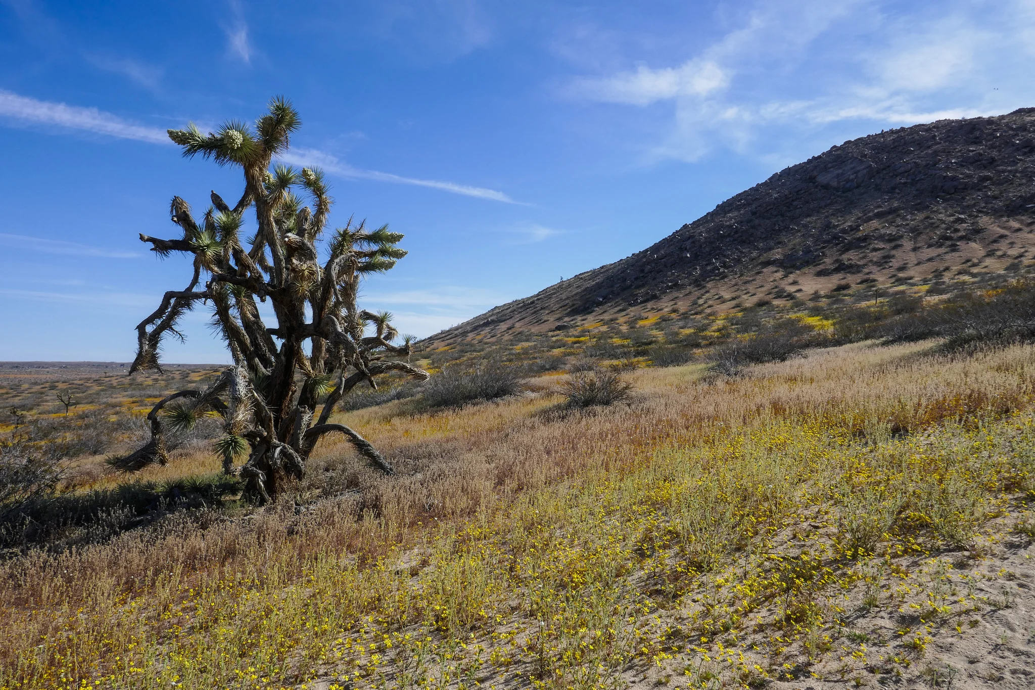
We hiked Little Butte and Saddleback Butte this weekend. I was here last year, but had not gone during the wildflower bloom. It was magical! We started our hike on the Dowen Nature Trail which connects to the Little Butte Trail and eventually the trail leading up to the top of Saddleback Butte at 3,651’. I immediately began to see carpets of wildflowers blanketing the park and the Fiddleneck flowers were covered in thousands of caterpillars. We took our time and admired all the beauty being offered to us here at the western edge of the Mojave Desert. I took note of some of the many wildflowers we observed. We saw: Coreopsis, Fiddleneck, Desert dandelion, Sun cups, Desert candles, Davy gilia, Fremont pincushions, Dune primrose, Wild Rhubarb and in addition, the Joshua Trees were in full bloom. Eventually, the sandy trail gave way to rocky terrain as it began its steep ascent up the top of Saddleback Butte. The wind was strong as we climbed and after a few easy rock scrambles, we were at the top enjoying the 360 degree views. To the south we could see the snow capped San Gabriel Mountains and further off in the distance we could make out Mt. San Gorgonio and Mt. San Jacinto. This was a really wonderful hike and being able to see the park in all it’s wildflower glory was a special treat!
I decided to take a vacation day on Monday so I could go hiking. We headed to Chantry Flats, but we weren’t sure whether or not we wanted to do a longer, more strenuous hike to Mt. Wilson or a shorter loop. We figured we’d decided when we got to the junction at Sturtevant Camp. Santa Anita Canyon was exceptionally beautiful today. There was so much water flowing in the creek. We took the Lower Winter Creek Trail that climbs up along the side of a rocky cliff to the top of Sturtevant Falls. The water was rushing strong and it looked awesome! As we hiked along the trail, we saw so many cascading pools of water. When we reached the junction near Sturtevant we made the decision to do the longer route to Mt. Wilson. I figured why not. I’d taken the day off and had no other place to be. As we started up that first steep mile, I was almost starting to regret my decision. My body was tired, but I didn’t want to turn around. We’d done this route last year, and I remember I really enjoyed it. We slowed up our pace which made it a little more bearable. It was a fun climb! Lots of beautiful scenery along the way. But I was very happy to reach to top because all I kept thinking about was sprawling out at one of the tables at the Cosmic Cafe and eating a ham and cheese croissant my husband had picked up at the donut shop before our hike! Once at the top, we had a nice rest. I took my hiking boots off to give my feet a break too. After we were finished refueling and recharging, we began the 7 mile descent back down the mountain. We took the Mt. Wilson Trail where you can still see quite a bit of fire damage to the Mt. Wilson Toll Road. There had been an avalanche since the last time we hiked on this road, and there were huge fallen boulders strewn across it. They were easy enough to get around, and I wondered what it must have sounded like when they came crashing down. We then reached the junction for the Winter Creek Trail and continued the long, steep descent on the switchbacks until we reached the bottom of the canyon. There were a lot of downed trees to hop along the way and there was also some trail erosion. The trail was still in good shape, but it does need a little TLC from the wonderful volunteers who help keep these trails passable so we can enjoy them. My knees and feet were getting tired, but the Winter Creek Trail is just so pretty. The final part of the hike was the grueling slog up the concrete road leading back to the parking lot. It seems to go on forever and it is steep! I was sweaty and tired by the time we got back to the trailhead, but it was so worth it. It’s been a while since we did any long, hard days on the trail so it felt really good to get out there and enjoy it!
We spent another day exploring Griffith Park. Our plan was to hike the North Trail from Mineral Wells Picnic Area and from there take the Mt. Chapel Trail to watch the sunrise from Mt. Lee which is where the Hollywood Sign is located. This is a non-traditional route to the sign, and I had not been able to find much much information about the Mt. Chapel Trail. We got started around 5:30 am and saw a couple of coyotes scavenging the picnic area for leftover food. As we hiked up, the city below looked really pretty. The lights were twinkling and there was a soft, warm wind blowing which made it seem kind of surreal. Up ahead I noticed the orange glow of an eye reflecting in the light of my headlamp. I wasn’t sure what kind of animal it was until I got closer and realized it was a little bird. It seemed strange to see a bird just sitting in the dirt and there was another one not far up ahead. Later, I did some research and learned that these nocturnal birds are called Common Poorwills. We continued up the hill until we reached the base of Mt. Chapel. It was about 20 minutes before sunrise, and at this point the wide trail turned into a rocky, narrow footpath hugging the hillside. We didn’t get too far on this when we realized we’d have some rock scrambling to do. I wasn’t comfortable scrambling rocks in the dark with only the light of our headlamps, especially since I didn’t know much about this trail. To play it safe, we backtracked and opted to see if we could make it to Mt. Hollywood for sunrise instead. We could always check out the trail again later when there was more light. We had about 15 minutes to reach our Plan B destination, and we made it there just in time! There were already a number of people on the summit ready to enjoy the sun coming up over Los Angeles. It was lovely. We then headed down to Captain’s Roost where you can find the “hidden palm trees” that you see in so many photos of Griffith Park. It’s just a short distance from the Mt. Hollywood summit, and it’s a great place for a photo op with it’s beautiful garden overlooking the city. From there, we continued our journey and headed toward Taco Peak. Taco Peak is a just small bump, but the climbing was a bit slippery due to all the loose little pebbles. The views at the top were nice, and from what I understand, there used to be a tea house here. After a quick snack break, we headed back towards Mt. Chapel to check out the Mt. Chapel Trail again now that there was daylight. After surveying the scrambling situation and some encouragement from my husband (I’m not a fan of rock scrambling), we made our way across the rugged trail over to Mt. Lee. I admit the rugged trail was a lot of fun and the views from the ridge were probably some of the best I’ve seen yet in Griffith Park. By this time the sun was warming things up and there were a lot of Painted Lady butterflies fluttering around the wildflowers. Eventually, the Mt. Chapel Trail intersected with Mt. Lee Drive and we met up with the crowds making their way up to enjoy the views from the summit of Mt. Lee and the back of the Hollywood sign. It was actually really fun seeing the Hollywood sign up close. I’ve lived here for so long now and never made it a point to go see it. But we didn’t stay very long since there were lots of people on top jockeying for a good view and the perfect photo. Even so, I would definitely recommending seeing the sign at least once just as long as you know what to expect as far as the amount of people you’ll be sharing the views with. After leaving Mt. Lee, we scrambled our way back across the fun Mt. Chapel Trail and back the way we came on the North Trail and to Mineral Wells. We put in about 9 miles. I am really enjoying exploring this park!
Today we headed back to Griffith Park again and this time accessed the trails from the north side. We didn’t have to get up as early to beat the crowds today, and we had much more solitude coming up from this direction. We took the Skyline Trail to the Mineral Wells Trail. From there we followed it all they way to the Bee Rock Trail. What an interesting spectacle Bee Rock is from below! We made our way up the steep single track to the top of the Bee Rock where the views, even though fenced in, were excellent! From Bee Rock we hiked a short distance on Vista Del Valle and then picked up the North Trail. From the North Trail we connected back to Mineral Wells and then back to the Skyline Trail in a lollipop loop. I have to admit I really underestimated Griffith Park. It has a very extensive trail system, and there’s a hike for ever level. You can make a whole day out of it or just a few hours if you so choose. The only problem we ran into was that there are many use trails throughout the park, so it can get confusing as to which one to take. I found myself referring to my map quite a bit. At the end of our hike, we both agreed we are very lucky to have this wonderful park within a few minutes drive from our home. We’ll definitely be coming here more often in the future.
Since moving to Burbank, we thought we’d give Griffith Park a try. It’s practically our backyard. The first time we went was last Sunday in the late afternoon where we did a short hike from Mineral Wells to Amir’s Garden. I liked it so much I wanted to come back and spend the whole weekend exploring more of the trails. I woke up early at 5 am on Saturday. I wanted to check out the southern end of the park and I knew accessing the trails from this end would be much more crowded. The parking was already starting to fill up when we arrived around 6:30 am. We hiked up the Riverside trail to the Hogback Trail to Glendale Peak and then the Mt. Hollywood Summit. The Hogback Trail was a nice workout! I really enjoyed this hike. It took a little getting used the being around so many people, but since it was a city hike, I knew that was to be expected. We had great views of DTLA and the hills were beginning to bloom with all kinds of flowers. This is going to be a great go-to place for us for hiking, especially when we aren’t able to make it up into the forest or even on a weeknight after work. After the hike today, we both agreed we wanted to come back and do some more exploring tomorrow.
The trek from Onion Valley to the top of Kearsarge Pass was a spectacular day hike! The Kearsarge Pass Trail heads west from the trailhead at Onion Valley entering the John Muir Wilderness at approximately .7 miles. On this 11 mile round trip journey, we passed through foxtail pine forests, crossed over boulder fields, hiked alongside waterfalls and aquamarine colored lakes filled with golden trout. A final rigorous high altitude ascent up a barren, rocky slope lead us to Kearsarge Pass where the trail crests the Sierra at an altitude of 11,835 breathtaking feet! We were rewarded with the most sublime views I have ever seen; the glaciated Sierra peaks, sparkling turquoise pools of water and views into Kings Canyon National Park. Here are some photos with captions below each to describe our incredible journey.
I woke up at 4:30 am excited to get started on our new adventure. We had a hearty breakfast and soon were on our way up Horseshoe Meadow Road to the Cottonwood Lakes Trailhead at 10,000’. I took my compass bearings, geared up and we were on our way by about 7 am. The trail enters the Golden Trout Wilderness and starts off on a leisurely stroll through the big pine trees. As we went along we started to gently descend. We followed along side a beautiful creek and made a few water crossings. The mosquitos were out in full force, so I was sure to break out the bug spray before becoming their early morning breakfast. We passed by lush green meadows dotted with wildflowers, corn lily and incredible views of large granite cliffs. Soon we entered the John Muir Wilderness. There was another creek crossing and more lovely meadows to enjoy before we came to the switchbacks. As we began to ascend our pace was slower than usual due to the high altitude. I did not mind stopping to take a few breaks so I could enjoy the views from above and take my photos. As we approached the top of the switchbacks, we could see some peaks coming into view. We passed a junction for Muir Lake and started to see the playful marmots poking their heads out waiting to see if we were going to give them hand out. The trail gently meandered through the meadow with a flowing stream and had incredible views of Cirque Peak and Mount Langley. It wasn’t long before the Cottonwood Lakes came into view. They were stunningly beautiful. We took a moment and sat in the shade to take a break, have a snack and enjoy the scenery, peace and quiet. We made our way to lake #3 and followed along its shore to a short climb up some switchbacks. On the other side we reached lakes 4 and 5. We felt a light breeze and could see the summer storm clouds rolling in closer, but I didn’t hear any thunder. We thought it was a good time to start heading back. We had quite a ways to go before reaching the end of our journey. As we made our way down the switchbacks we enjoyed another marvelous view of lake #3 from above. We passed a man with his two sons who were fishing, but he said they hadn’t had any luck. As we made our way back to the trailhead, I could feel some light precipitation. The cool raindrops on my skin felt refreshing after a long day and the smell of summer rain mixed with the pine was intoxicating. We got back to the trailhead around 3:30 pm and clocked about 14 miles. It was my first time hiking for that long at such a high altitude and I was both tired and exhilarated at the same time. It was an incredible experience. The Eastern Sierra has so much to offer. I have fallen in love.
We thought we’d try one of the other hikes in the Mount Baldy area this past Sunday, so we choose Stoddard Peak. This hike starts off as an easy hike along a scenic fire road, but once you arrive at Stoddard Flat, get ready to do some bushwhacking, rock scrambling and climb over two false summits to get to your final destination. Once you reach the peak, the views are awesome. We had a perfectly clear day and a spectacular view of our majestic Mount Baldy. Being this is not one of the more popular hikes in the area, we only saw a few other hikers along the way and had the peak to ourselves. It was a fun day!
We’ve been doing a lot of canyon hikes lately. Devil’s Canyon was another one I’ve had on my “to do” list since we’ve been driving past it on the way to other hikes. The trail takes you down into the rugged San Gabriel Wilderness. It follows a babbling brook into the heart of Devil’s Canyon where it opens up to flat, sandy trail next to sparkling pools, cascades and smooth boulders that make a great place to have lunch. There’s also a primitive backcountry campground that you can stay at just a little further up the trail. I liked this hike a lot. The trail is quite narrow in many spots so you need to stay focused, but it’s not sketchy. The grade is also gradual, so climbing up isn’t so bad since you’ll gain all your elevation on the way out.
It was 6:30 am Sunday morning and we were on the trail headed to Trail Canyon Falls, a beautiful waterfall cascading 30 feet down into a rugged canyon. What this hike lacks in distance, it makes up for in beautiful scenery. The trail to the falls winds through the canyon and crosses the creek several times before heading up to the top of the waterfall where you’ll have spectacular views looking straight down. If you’re feeling adventurous you can also descend a steep use trail where you can rock scramble your way down with the help of a rope tied to a tree to get to the base of the falls. Today the water was flowing beautifully, the wildflowers were blooming and butterflies were on the wing. Since we started so early, we shared the falls with only two other hikers. It was a very peaceful morning. As we headed back, I came upon a very hungry swallowtail who was so busy nectaring on Western Wallflower that he didn’t seem to mind me hovering over him with my camera to take some photos. Also, if you keep your eyes peeled, there’s a picnic table nestled away in the shade off to the side of the trail that makes for a great place for a snack break or even a picnic. We stopped there for a bite to eat before finishing up the hike. It was an absolutely perfect day with temperatures at about 65 degrees at 10:30 am when we arrived back at the trailhead.
Angeles National Forest is practically in my backyard. I’ve visited a few times in the past, but it wasn’t until recently when I discovered the work of David Horner, a Santa Monica based photographer who specializes in wild butterfly photography (solardarkroom.com) that my interest was piqued. His California Butterfly Project (over 10 years in the making) includes over 100 species that he photographed in the wild from sea level to 10,000 ft. from the border to Sonora Pass in the Sierra Nevada. I took notice that many of his sightings were located right here in the Angeles National Forest. About two years ago, I started a butterfly garden, Since then I’ve become somewhat of a butterfly enthusiast mostly observing them in my backyard and on my visits to local public gardens. When I saw the number of different butterfly species we have here in California on David’s website, I was inspired to revisit Angeles NF not only in the hopes of viewing butterflies in their natural habitats, but also to take advantage of the multitude of hiking trails. Years ago when I lived in Pennsylvania, I did quite a bit of hiking on solitary trails surrounded by nothing but the birds, the trees, the wildlife and peace and quiet. But now that I’ve been living in a big city, I didn’t really think too much about what else was available here aside from the overly populated locations such as runyon canyon or hiking up to the Hollywood sign. This past weekend I recruited my husband as my hiking partner (since you should never hike alone) and we ventured into Angeles NF. The drive alone up the winding roads offers such spectacular views. I’d planned ahead and decided our destination would be to hike from Charlton Flats to the top of Vetter Mountain. As we climbed up the trail, I was able to see first hand some of the damage done by the 2009 Station Fire which burned more than 161,000 acres. I also noticed lots of poodle dog bush which is a plant that causes skin irritation similar to poison oak if touched. Much of this was located within the burn area perimeter and as I later learned, it’s usually found in nearly all habitats that have been burned. Winding up the mountain, the trail was nothing less then spectacular with breathtaking views and wildflowers. We detoured off the main path to do an out and back trek along the Silver Moccasin trail which traversed upward and down through oak-lined canyons and high ridges. One day I’d like to take that trial a little further, as I didn’t want to get too side tracked since our goal was to reach the top of Vetter Mountain. After getting back on the main trail, we continued our journey until we reached the top of the fire lookout at Vetter Mountain. There we shared friendly conversation with forest rangers who were happy to answer our questions about the location. These people stand guard daily over our beautiful forest with nothing but a small shelter. The actual lookout tower was burned in the Station Fire. I have to give them credit for being up there all day watching out for us with the wind and colder temperatures on the 5,903 ft. sumit. We then climbed to the top of what remains of the old lookout and stood for a moment to enjoy the 360 degree view of the San Gabriel Mountains. With mission accomplished, it was time to head back. Round trip with our Silver Moccasin detour we did about a 7 mile, 2.5 hour hike. My hope for the day was to possibly photograph at least one wild butterfly. My wish was granted by a little common branded skipper who I saw fluttering along the trail as we got closer to where we started at Charlton Flats. It was a great morning and I will definitely be visiting Angeles NF more frequently to take advantage to all that it has to to offer including butterfly sightings and more hiking adventures.