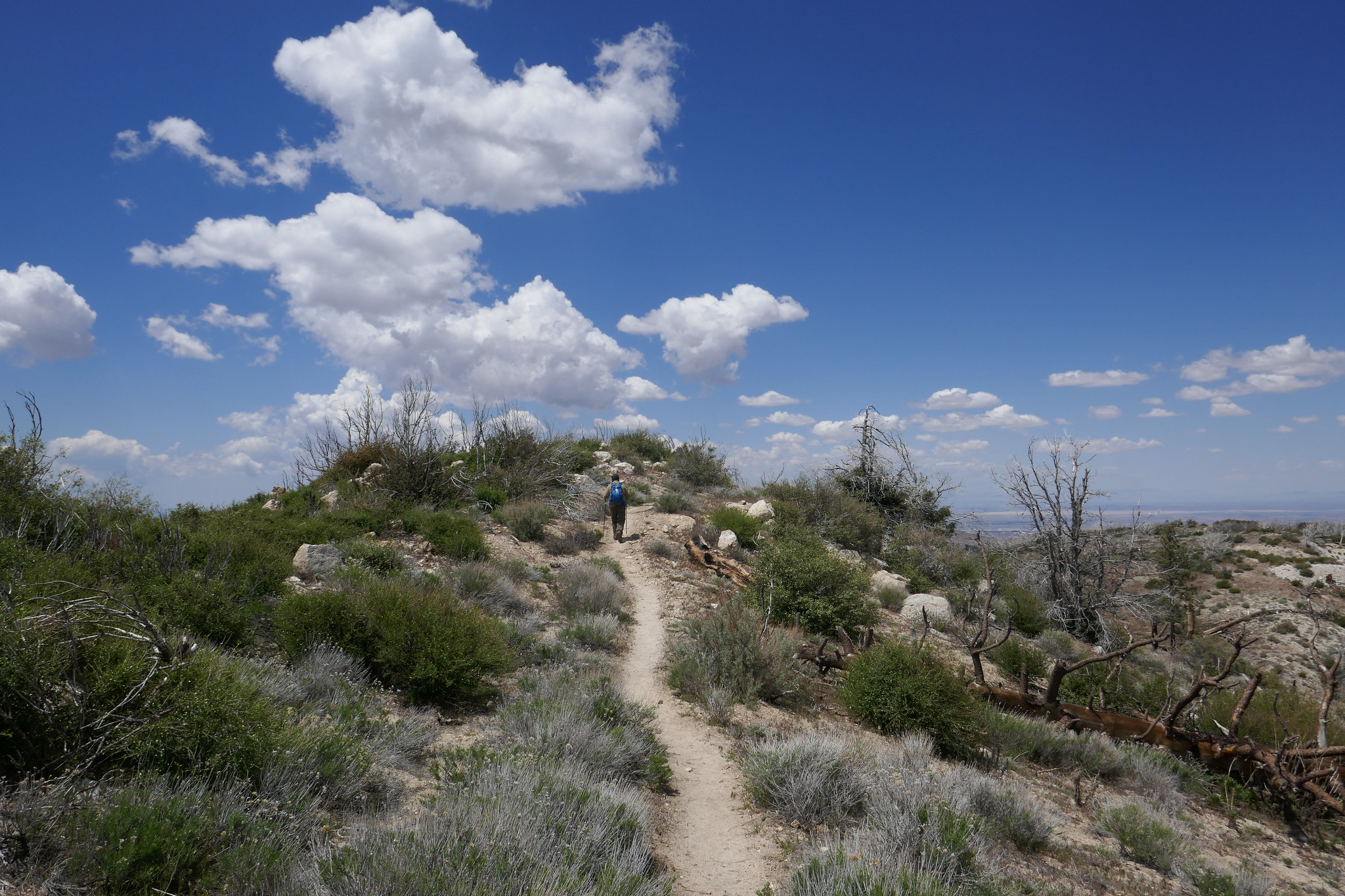
Hiking the Panorama Loop from Black Rock Campground. This hike starts in the far northwest section of Joshua Tree National Park. You can park at the Black Rock Canyon Campground where there’s a visitors center and bathrooms. From there, look for campsite #30 and you’ll find the trailhead. You’ll see a water tank and a dirt road which you will follow southeast for a short distance until you are on a dirt trail. You’ll reach a sign for the Panorama Loop and Warren Peak via Black Rock Canyon Trail. Much of the trail is hiking through a sandy wash with a moderate incline. You’ll be winding through canyon walls here and as you continue, you’ll notice the lush greenery beginning to present itself. This area is abundant with pinyon pine, juniper and oak. You’ll also discover a spring. But keep your eyes peeled because it’s easy to miss. When we were here in February it was just a trickle. However, there is plenty of wildlife to be seen in this area such as insects, birds, rabbits, and ground squirrels. It’s a very unique section of the park. At about 1.7 miles in you’ll find the signage for the start of the loop to Panorama Peak. If you hike it clockwise, you’ll have a steeper climb up, but it will save your knees on the way down the other side. As you do the work to ascend, you’ll be rewarded with views of snow capped Mt. San Gorgonio. Continue upward on the steep switchbacks for incredible panoramic views of Mt. San Jacinto, Yucca Valley, Mt. San Gorgonio and the Coachella Valley. You can even catch a glimpse of the Salton Sea. When you’re ready to return, follow the ridge and descend down into a wash where you’ll continue to enjoy the lush terrain along with majestic Joshua Trees. Eventually, you’ll be back at the start of the loop and return the way you came. It was a beautiful hike. Much different then the typical terrain I’m used to seeing in the desert.
What a beautiful mountain. There are so many blooming wildflowers this time of year. We did this hike last year in June and the weather was very hot. This time the weather was still warm, but definitely not as bad. Again, just as last year, we saw very few people other then the PCT thru hikers passing by on their way to the Sierras. We put in quite a lot of mileage and the day was made even longer by my stopping to take photos every few minutes. The best hikes are always the ones where I take my time and don’t feel like I’m in a rush against the clock or in a big hurry to reach the summit. Now that we’ve been hiking for a few years and have hiked many of these mountains, I don’t feel such an urgency to summit and I’m taking more time to stop and really appreciate and enjoy the beauty of my surroundings. Even though Pacifico Mountain was hit hard in the 2009 Station Fire and there’s still a lot of visible damage along the route, it’s a very pretty hike. The area is incredibly beautiful with great vistas and it is full of flowers and wildlife. In fact, we can in very close proximity to a rattlesnake towards the end of the hike and only about a half a mile away from the trailhead. We didn’t see the snake, but we did hear the warning rattle. She must have been alongside the trail hidden where we couldn’t see her. It’s amazing how they can disguise themselves. As we climbed up the mountain, the trail changed from charred trees to beautiful Jeffery Pines. We had lunch at the campground on top of the summit. It would be so nice to camp here sometime. There were a good number of ravens circling and I saw several species of butterflies including painted ladies, swallowtails and duskywings. We spent good amount of time at the top before leaving. There was no one there but us. I scouted around the big boulders to see if I could find the official USGS marker, but I still couldn’t locate it. I’ll check again next time we’re here. It was a really nice day.
I decided to take a vacation day on Monday so I could go hiking. We headed to Chantry Flats, but we weren’t sure whether or not we wanted to do a longer, more strenuous hike to Mt. Wilson or a shorter loop. We figured we’d decided when we got to the junction at Sturtevant Camp. Santa Anita Canyon was exceptionally beautiful today. There was so much water flowing in the creek. We took the Lower Winter Creek Trail that climbs up along the side of a rocky cliff to the top of Sturtevant Falls. The water was rushing strong and it looked awesome! As we hiked along the trail, we saw so many cascading pools of water. When we reached the junction near Sturtevant we made the decision to do the longer route to Mt. Wilson. I figured why not. I’d taken the day off and had no other place to be. As we started up that first steep mile, I was almost starting to regret my decision. My body was tired, but I didn’t want to turn around. We’d done this route last year, and I remember I really enjoyed it. We slowed up our pace which made it a little more bearable. It was a fun climb! Lots of beautiful scenery along the way. But I was very happy to reach to top because all I kept thinking about was sprawling out at one of the tables at the Cosmic Cafe and eating a ham and cheese croissant my husband had picked up at the donut shop before our hike! Once at the top, we had a nice rest. I took my hiking boots off to give my feet a break too. After we were finished refueling and recharging, we began the 7 mile descent back down the mountain. We took the Mt. Wilson Trail where you can still see quite a bit of fire damage to the Mt. Wilson Toll Road. There had been an avalanche since the last time we hiked on this road, and there were huge fallen boulders strewn across it. They were easy enough to get around, and I wondered what it must have sounded like when they came crashing down. We then reached the junction for the Winter Creek Trail and continued the long, steep descent on the switchbacks until we reached the bottom of the canyon. There were a lot of downed trees to hop along the way and there was also some trail erosion. The trail was still in good shape, but it does need a little TLC from the wonderful volunteers who help keep these trails passable so we can enjoy them. My knees and feet were getting tired, but the Winter Creek Trail is just so pretty. The final part of the hike was the grueling slog up the concrete road leading back to the parking lot. It seems to go on forever and it is steep! I was sweaty and tired by the time we got back to the trailhead, but it was so worth it. It’s been a while since we did any long, hard days on the trail so it felt really good to get out there and enjoy it!
We had quite a bit of rain over the past few days and I really wanted to try snowshoeing. We had already made plans months ago to spend the weekend in Twentynine Palms, but instead of hiking in the desert like we normally would have, we decided to take the Palm Springs Aerial Tramway up to Mt. San Jacinto. We rented snowshoes from REI in Burbank and were lucky to get the last two pairs available for the upcoming weekend. Seems everyone had the same idea: Take advantage of the snow while you can. I got up at 4 am and we were on our way by 5 am. When we arrived in Palm Springs at 7 am, the parking lot was already getting filled up; families with sleds, coolers, snowshoes, etc., all gearing up for a winter play day. We got our tickets for the 8 am tram and were on our way up the mountain in no time. The tram is a unique activity to do in and of itself. I never get tired of being hoisted up a steep cliff inside a floating bubble travelling up a cable. The transition from desert floor to sub-alpine is amazing and in just 10 minutes we went from the desert floor at 2,643’ at Valley Station to 8,516’ at the top of Mountain Station. The air at the top of the tram was in the 30s. The snow was hard packed and crunchy with some ice. We headed over to the Desert View Loop to try out snowshoeing for the first time. It was actually quite easy. To me it felt a bit like an elliptical machine. The Desert View loop is a short trail with a gentle incline and five notches overlooking wonderful views. It was the perfect place to start. After we had gotten the hang of things, we headed over to Long Valley Station where we filled out a permit and continued on into the San Jacinto Wilderness with our destination being Round Valley. By this time, more people had arrived, some wearing microspikes and there were many groups of snowshoers and winter backpackers. I really enjoyed being able to “float” on top of the snow in the snowshoes. I also liked having a sturdy grip with the snowshoes’ crampon that dug its teeth into the hard packed snow for traction. I felt very secure both ascending and descending. There were a number of people on the trail today, but we were still able to enjoy some alone time. After arriving at Round Valley, we contemplated going up one more mile up to Wellman’s Divide. But instead, we changed our minds and decided to start heading back, knowing we had a cozy room waiting for us in Twentynine Palms. The weather was warming up now, and the snow was starting to get slushy. I think it was a little after 2 pm when we arrived back at Mountain Station. We had no problems getting on the next tram down and were headed out to spend the rest of the weekend relaxing and enjoying the desert. It was a wonderful day. I think I am hooked on snowshoeing and I cannot wait for the opportunity to do it again!
My favorite part of the hike to Josephine Peak are the spectacular views. It’s a steady 4 mile climb to the peak, and today we had a nice, clear day since it had just rained. As we travelled up the fire road from Clear Creek Station just off Angeles Crest Highway, we could smell the eucalyptus trees and the yerba santa. It was even more fragrant today since it had just rained. I’m not quite sure how the eucalyptus trees got here since they’re not native, but they sure do smell nice. As we continued hiking up the trail, I started to get some great photo ops. Strawberry Peak looked quite impressive and we could see a dusting of snow covering the mountaineer’s route. We also had a nice, clear view of DTLA. The views went out all the way to the ocean. To the north, the high country was covered in fresh snow; Waterman, Baden-Powell, Twin Peaks, etc. As we neared the summit of Josephine, we crossed over a bit of snow ourselves. When we arrived at the peak, the views were even more incredible. The last time we were here we were shrouded in clouds so we didn’t get the 360 degree views that we had today. I took advantage and snapped away with my camera. It was absolutely lovely. After spending some time at the summit and greeting a few fellow hikers who’d come to enjoy the day as well, we decided it was time to begin our descent. The clouds started to roll in as we hiked back down the mountain, but we didn’t see any rain. It was an absolutely perfect day.
Our first hike of 2019 was to Mount Hillyer. I love this hike. There’s so much going on. Lots of great rock formations and change of scenery along the way. It was 39 degrees at Chilao where we picked up the Silver Moccasin Trail with wind gusts up to 50 mph expected at the summit. We had a great hike up. The breezy day was refreshing and there’s not much exposure on this trail with all the boulders, so we were protected from the wind for most of the route. There was a downed tree on the switchbacks of the Silver Moccasin trail. I’m not sure if it was caused by the winds, but luckily it was easy to maneuver over. As we continued our journey upward, the winds became stronger. My core was warm with all my layers, but for some dumb reason I didn’t wear a bottom base layer under my hiking pants. I don’t know where my head was this morning. I knew there would be a wind chill, and I’m usually the one who is over prepared with too much gear. When we reached the gusty summit, I could feel the tops of my legs getting numb. We hauled butt pretty quickly down off the exposed mountain top. I haven’t felt that numb feeling set in since Pennsylvania when I would spend the entire day at the barn riding and taking care of my horses in temperatures below zero some days! Once out of the big gusts, my legs warmed up and we continued our descent. About 1:30 pm, we heard a loud roar in the sky. As we looked up we saw two B-2 Spirit Stealth Bombers flying overhead. They were probably headed back to base after the Rose Parade. Last year we got to see one of them from the top of Waterman Mountain. I didn’t think we’d get to see that this year, but we actually got to see two of them! It was a great way to begin the New Year!
My husband and I did a sunset hike on Mt. Lowe this past Sunday. We drove up to Eaton Saddle, followed the Mt. Lowe Fire Road through the Mueller Tunnel to Markham Saddle and then picked up the trail to the Mt. Lowe summit. I really like this area a lot. There’s never very many people and you get some great views of the rugged San Gabriels. The hike to the summit is a short one, but it was perfect for a day when we didn’t have time to do a long hike. The views are pretty great too. As the sun began to sink behind the Santa Monica Mountains to the west, we started to make our way back down the mountain. We reached Markham Saddle just 10 minutes before the sunset then stopped to enjoy the show as the light faded from orange, to pink and finally inky black. It was a little spooky coming back through the Mueller Tunnel in the dark, but the city below us lit up in a romantic, sparkling glow of lights. It was a great way to wrap up the weekend!
For my upcoming birthday I asked my husband for a Jetboil cooking system. It would be the first item in a long list of backpacking gear that we’re going to need to make the crossover from day hikers to backpackers. Since I’d been looking for an excuse to make the short hike up the little bump called Mt. Akawie (aka Buckhorn Peak if you’re using a Tom Harrison map), we headed up to the mountain to test the new cooking system and spend a quiet morning together.
We hit the trail just after 6 am. After a very short distance we took the path leading up to the peak. There appeared to be a number of fire roads around to explore, but we were ready to get cooking and I couldn’t wait for a hot cup of coffee. The Jetboil system did not disappoint! For breakfast I’d packed a couple of Eggo waffles (my favorite) and brought along a freeze dried breakfast scramble from Mountain House. Overall, it was pretty good. I definitely could live on this stuff for a couple of days in the backcountry. After eating, we got comfortable on one of the large, flat bounders looking towards Waterman Mountain and Twin Peaks and napped for a short while. After a peaceful rest and stomachs full of interesting freeze dried food, we packed up our gear and did some exploring around the mountain both on and off-trail. An unmaintained road/trail took us northeast around the bump and offered views looking towards Pleasant View Ridge. We also saw a lot of deer; mostly doe and one with a young fawn. The road/trail eventually disappeared and we made a scramble up the east side of the mountain before heading back the way we came. It was around 11 am when we got back to the car. We thanked Mount Akawie for the hospitality and headed home to enjoy what was left of our weekend.
We watched the sunrise from Cloudburst Summit as we geared up and got ready to hike to Winston Ridge and Winston Peak. We’d been to Winston Peak a few times before, but we had climbed it from the north side. This time our plan was to hike to Winston Ridge first (which we had not done) and then tackle the steep ascent up the use trail on the south side of the mountain to Winston Peak. We began the hike by descending the fire road and heading northwest on the PCT. When we reached a small saddle with Bump 6903 we had a choice to climb up and over the bump or hike around it to the left or to the right. From the research I’d done it seemed taking the use trail to the left was going to be our best option. The trail was quite rugged with soft dirt and loose rock that would give way if you weren’t careful. We had a number of downed trees to negotiate as well. There was one rather large tree that was particularly challenging. (I will talk more about that later.) This rugged section of trail tested our agility for sure, but it was definitely a lot of fun. When we reached another saddle, we continued northwest to reach the high point on the ridge. The hike along the ridge was undulating and lovely with views of Squaw Canyon to the south and Pleasant View ridge on the opposite side. We could also see the transition zone from forest to desert. We hiked past the high point on the ridge and came to a rock formation that reminded me of the back of a stegosaurus sticking out of the ground. I examined it looking for a way to get around it, but it looked a little sketchy, so I opted not to continue any further. We took a long break on the ridge and chatted about how nice it was to be the only ones here. For such a fun hike I was surprised it didn’t have more people on it. But being I like my solitude, I was not complaining. I explored some of the interesting rock formations and checked out the views in all directions while my husband made some contacts on his HAM radio. Before continuing the journey, we signed the summit register which was tucked away in some rocks marked by a rock cairn. We then started heading back enjoying the views and the scenery along the ridge. As we got closer to the saddle, I had a good perspective of that very large downed tree I’d mentioned earlier. We had climbed over it on the way to the ridge and it looked awfully menacing from this angle. When we reached the downed tree, my husband went over first (as we had done on the way to the ridge) so I could hand him my backpack making it easier for me to maneuver up and over. The footing here was loose, and we had to be extra careful. We continued along the slippery slope and at one point we diverted slightly off trail after negotiating another downed tree. We could see the saddle and Winston Peak right in front of us and were able to correct ourselves right away. Once back at the junction with the PCT, we had the choice of hiking back the way we came, or we could make the steep ascent up the south side of Winston Peak on a use trail. We decided to take on the challenge! The climb showed no mercy, but it sure was fun! The ground wasn’t nearly as slippery as what we’d experienced on the way to the ridge. I turned around to look back a few times to take in the wonderful views of Winston Ridge and snap some photos. This was also a good excuse to catch my breath. The climb seemed to go on and on, but I could see the top and I knew we’d be there in no time. Once at the top of Winston Peak, we gave each other a high five. We both felt pretty accomplished! I wandered around the summit for a while climbing about the rock formations and keeping an eye out for a summit register. I never did find one. We then descended down the north side of the mountain and back to Cloudburst Summit. I had actually wanted to include the short hike to Mount Akawie (aka Buckhorn Peak) on this trip, but both of us decided what we really wanted was a bacon cheeseburger and some fries! It was well earned after this climb!
Kratka Ridge has been on my radar to hike for quite some time. We made a plan this weekend to go check it out and when mapping out the route, I added nearby Peak 7160 to the plan. The whole hike was only a little over two miles, but in that short distance we were offered amazing views, a fun, steep climb and plenty of solitude. We arrived at the trailhead at the Vista Picnic Area around 6:30 am. The route wasted no time ascending quickly and offering great views. As we continued there were sections where the ground was soft and the footing was loose making the going more challenging. It wasn’t long before we reached the ruins of an old, wooden ski lift that had been in operation from the 1950s up until 2001. Now its deteriorating structure sits abandoned with single seat ski lift chairs hanging from the cables. We spent some time exploring the structure and tried to imagine what it had been like when it was up and running. We sat inside the old ruins looking down the mountain towards the rickety lift chairs enjoying each other’s company and the quiet of the morning until it was time to continue up to the high point on Kratka ridge. Behind the ski lift I discovered what looked to be a use trail that would require some scrambling up rocks and tree roots to reach the top. I continued to explore the area looking for the best way up and just a little further past the wooden structure I found another use trail on the side of the slope that would also take us to the top. The trail was narrow and a bit loose, but I felt comfortable enough to negotiate it to reach the high point from this route. At the top of Kratka Ridge we were rewarded with some of the most excellent views of Bear Creek Canyon and the San Gabriel Wilderness I have ever seen. I could identify Mount Williamson, Waterman Mountain, Twin Peaks and many of the other surrounding mountains from the viewpoint. After we were done taking it all in, we found another faint trail which followed the wilderness boundary. I figured it would take us back to the scramble behind the lift and sure enough it did. We then began our descent down the mountain being extra careful on the slippery sections. As we descended I could see Peak 7160 right in front of us. There wasn’t much of an established way up, so we started heading towards its high point. The ascent was steep, but the footing was fine. Along the way I found a heart that someone had made out of pine cones. When we reached the summit, I found another one made out of stones. So cute! From Peak 7160 we had a great view looking back over at Kratka ridge and down into the canyon. It was a lovely day. Although it was short, this hike is definitely a favorite!
The best time for hiking during the hot summer months is EARLY! I like to be on the trail either before sunrise or shortly after so I can enjoy my time on the trail before the day heats up. This is also the time of year when I like to stick to the high country or look for higher elevation hikes which are usually a bit cooler than those at the lower altitudes. Mount Williamson was the perfect hike for today; a short 5 miles from the Islip Saddle trailhead with a little bit of an elevation gain and a fun climb. The early morning sunlight was brilliant as we headed up the trail which starts off on the PCT. It wasn’t long before views of Mount Islip opened up to the south on the opposite side of the Angeles Crest Highway. The hike to Mount Williamson is a fun one. We did this last year in September and I really enjoyed it. The climb is mostly steady until you get closer to the top where you leave the PCT and the trail to Mt. Williamson becomes quite steep and rugged. Once at the top we had wonderful 360 degree views. It was only us on the summit so we took our time, had some snacks and after orienting my map, I spread it out and secured it with some rocks so I could use it to identify some of the surrounding features of the area. Many of the surrounding peaks were visible including Mount Lewis, Mount Baden-Powell, Throop Peak, Mount Hawkins and Twin Peaks to name a few. To the north I could see all the way out to the Mojave Desert and to the southwest I had a nice view of Williamson Rock, which was once popular with rock climbers until the area was closed off to protect the mountain yellow-legged frog. It was barley 9 am and already I could feel the sun starting to heat up the day, so we headed back enjoying our time on the trail and the sweet, vanilla fragrance of the Jeffery pines along the way.
We headed into the local mountains on Sunday for a nice easy day of hiking in the Los Padres National Forest. We did a short 8 mile hike to Mt. Pinos and Sawmill Mountain. We did these peaks in May of this year and at that time we also added Grouse Mountain which completed the 3-2-1 challenge. (Check out mymountainchamber.com for info. on the challenge.) . It's a lovely area to explore. This time around the weather was much warmer then the last when it was cool and cloudy. I got to see some butterflies and the highlight of my day, a horned lizard. He blended in so well with his surroundings that I could barely see hime when looking through my camera lens. After reaching Sawmill Mountain and taking in the views from there, we decided to head back before the day got too hot. This was a nice hike to ease us back into it after an incredible 3 days spent in the Eastern Sierra.
I woke up at 4:30 am excited to get started on our new adventure. We had a hearty breakfast and soon were on our way up Horseshoe Meadow Road to the Cottonwood Lakes Trailhead at 10,000’. I took my compass bearings, geared up and we were on our way by about 7 am. The trail enters the Golden Trout Wilderness and starts off on a leisurely stroll through the big pine trees. As we went along we started to gently descend. We followed along side a beautiful creek and made a few water crossings. The mosquitos were out in full force, so I was sure to break out the bug spray before becoming their early morning breakfast. We passed by lush green meadows dotted with wildflowers, corn lily and incredible views of large granite cliffs. Soon we entered the John Muir Wilderness. There was another creek crossing and more lovely meadows to enjoy before we came to the switchbacks. As we began to ascend our pace was slower than usual due to the high altitude. I did not mind stopping to take a few breaks so I could enjoy the views from above and take my photos. As we approached the top of the switchbacks, we could see some peaks coming into view. We passed a junction for Muir Lake and started to see the playful marmots poking their heads out waiting to see if we were going to give them hand out. The trail gently meandered through the meadow with a flowing stream and had incredible views of Cirque Peak and Mount Langley. It wasn’t long before the Cottonwood Lakes came into view. They were stunningly beautiful. We took a moment and sat in the shade to take a break, have a snack and enjoy the scenery, peace and quiet. We made our way to lake #3 and followed along its shore to a short climb up some switchbacks. On the other side we reached lakes 4 and 5. We felt a light breeze and could see the summer storm clouds rolling in closer, but I didn’t hear any thunder. We thought it was a good time to start heading back. We had quite a ways to go before reaching the end of our journey. As we made our way down the switchbacks we enjoyed another marvelous view of lake #3 from above. We passed a man with his two sons who were fishing, but he said they hadn’t had any luck. As we made our way back to the trailhead, I could feel some light precipitation. The cool raindrops on my skin felt refreshing after a long day and the smell of summer rain mixed with the pine was intoxicating. We got back to the trailhead around 3:30 pm and clocked about 14 miles. It was my first time hiking for that long at such a high altitude and I was both tired and exhilarated at the same time. It was an incredible experience. The Eastern Sierra has so much to offer. I have fallen in love.
Our original plan for our trip was to hike the Mount Whitney Trail to Lone Pine Lake, but I learned the night before a fire which was caused by lightening strike had closed Whitney Portal Road at Hogsback and there was no access to the Whitney Portal Trailhead. Upon arrival, we stopped at the Eastern Sierra Interagency Visitors Center to talk to the rangers, pick up some additional maps and decide on our best "plan b" options which we gathered the night before. I had several ideas in mind, of them being a nice, long day hike to Cottonwood Lakes which was then recommended to us by the rangers. So Cottonwood Lakes it was! We already had the maps for that, so I picked up a visitor's guide and a whole slew of other maps for future trips and we were on our way to do a little sight-seeing before the next day's trek. Our first stop was the Alabama Hills where the rock outcrops frame incredible views of Mount Whitney. From here we could see the Georges Fire burning, and the smoke was pluming towards the north so the air quality seemed to be okay at our location. I took some photos and then we headed off to check out the trailhead for where we'd be hiking the next day. From Whitney Portal Road before the closure, we turned onto Horseshoe Meadow Road which is an adventure unto itself. The paved road switchbacks up the mountain 6,000 feet from Lone Pine's desert floor, all the way to an elevation of 10,000 feet with its terminus at Horseshoe Meadow. We drove around to scope out the area, make note of where our trailhead would be and then stopped off at the day use area to have a picnic lunch before heading back to check into our hotel. It was later in the afternoon by now and we could see the gray clouds forming and hear the soft sound of rolling thunder off in the distance. The threat of storms are very common in summer. If there's one thing I know about mountains at this high an elevation, they make their own weather so you have to be prepared for anything and know when to descend. It was very peaceful up there as we listened to the soft booms that were farther off in the distance. I pulled the maps out of the car to check out the terrain so we could get an idea of what to expect along our destination the next day. Later that evening after stopping in Lone Pine for a bite to eat, we head back to the Alabama Hills for a quick little stroll to Mobius Arch, a natural arch that is formed in the rock formations. A lot of people like to take photos through the arch because it frames Lone Pine Peak quite nicely. I didn't make take the classic shot at the arch since there was another photographer there who had his equipment set up and I didn't want to disturb him. Instead I walked just around the side of Mobius and found Lathe Arch and took my shot there. As the sun was setting we could see the embers from the fire burning. It was a lovely sunset, but we needed to get back to the hotel so we would be well rested for our hike to Cottonwood Lakes the next day.
Today we started out with a plan to do “just a short hike”. Well, by now I should know that it rarely ever works out that way. We didn’t feel like driving too far so we decided to stick closer to home and take a ride up to Eaton Saddle. We hiked up the Mount Lowe Road, through the Mueller Tunnel (which I think is absolutely amazing) and reached Markham Saddle. At that point we had several options to climb the peaks that we’d done before; Mt. Lowe, Mt. Disappointment, San Gabriel Peak or we could continue on the Mount Lowe Road. I pulled out the map to see where it would take us. It looked to be a little over four miles to reach the Mount Lowe Trail Camp and Inspiration Point (which we’d also been to before, but never from this direction). We decided to give it a go. What a great route! I’m so glad we did it. This area has so much history. Not only was this a very low stress, no cliff hugging ledges kind of hike, but it also had a lot of butterflies. After reaching Inspiration Point, we continued along the fire road past the crowd of people until we reached the junction to summit Muir Peak. I knew we’d have the peak all to ourselves along with the views to boot. My husband and I hung out up there for a while. I chased around the Chalcedon Checkerspot butterflies trying to get some photos while my husband talked on his HAM radio. There was a lot of California Buckwheat up on this peak, hence all the butterflies. I even got one to sit on my finger. The surrounding views were terrific; Pasadena and the city below, Mount Wilson, Occidental Peak, Mount Harvard, San Gabriel Peak, and Mount Lowe to name a few. After we were done enjoying having the place to ourselves, we started heading back. By this time it was getting pretty warm and much of the morning shade we had earlier was almost gone. Thankfully, we always come prepared with plenty of water and there was a nice, refreshing breeze every now and then to help keep us cool. As we hiked back, the road was buzzing with butterfly activity. There were plenty of Blues, Swallowtails, Chalcedon Checkerspots, Hairstreaks and I was also able to find and photograph the elusive Great Basin wood-nymph. As always, it was another great day to be in the mountains!
I’m always looking to escape weekend crowds and find new trails to explore. This Sunday our hike was to the top of Mount Pacifico in the northern part of Angeles National Forest. We planned to start the hike at Mill Creek and follow the PCT which runs through this area. It looked like the trek would be around 12 to 14 miles depending on whether or not we did an out and back on the PCT or did a loop. The day was going to be hot, but I figured since we were heading up to a higher elevation, it might not be so bad on the ascent. If it got too hot, we would descend and save it for another time. The trail was very beautiful. There were many wildflowers and so much ceanothus (California lilac) which made for a very pleasant fragrance along the way. There was lots of wildlife activity too; squirrels, chipmunks, songbirds, bees, insects and butterflies. As we climbed higher, we started to see beautiful, tall pine trees. Much of the area was burned in the 2009 Station Fire, and we could see the effects of that as we hiked this route. But the area looks as though it’s been recovering nicely. Eventually, we reached a junction where we left the PCT and headed southeast to a jeep road that took us up to the summit. There are outstanding views of the surrounding mountain ranges along the way making the road more interesting. After about a mile or so we reached the summit. Mount Pacifico Campground is also here. There are picnic tables, a fire ring and vault toilets. That’s quite a luxury to have up on a summit! There are also a lot of very interesting rock formations to explore. There wasn’t anyone here today, so we took a good long rest and relaxed and enjoyed the peace and quiet. Soon it was time to head back and get ready for the heat as we descended to a lower elevation. We opted to come back the way we came on the PCT for a more scenic and enjoyable route. Both of us had been keeping well hydrated throughout the trip and we had no problems with it being so warm. We were even gifted with an occasional breeze as we hiked back down the mountain. I found this trail to be very nicely graded so although it was long, it was very pleasant. A very enjoyable hike!
We wanted to try out a different route to Mount Baden-Powell, so we decided to start our hike from Dawson Saddle. It adds a little bit of extra mileage, but there are really great views along the route because much of this hike follows along the ridge once you reach the junction for the PCT. It's also less heavily trafficked then the route up from Vincent Gap. Since Baden-Powell was added to the Six Pack of Peaks Challenge, it's become increasingly popular. We actually only planned on hiking to Baden-Powell, but we had the time and decided to go up to Mount Burnham and Throop Peak which were close by. I should note that all of my photos were taken with my Android phone today. Somehow I managed to forget my camera which was a big disappointment because I love doing my photography along the way. I really enjoyed this route and trying out a new trail. After the hike we drove into Wrightwood for a bite to eat. On the way we passed by the trailhead at Vincent Gap and it was mobbed with cars! I couldn't believe how crowded it was. I was grateful we didn't go up that route today. Looks like we'll need to save the Vincent Gap route for a weekday when it's less busy. Baden-Powell is a lovely peak. It's also nice to say hello to the 1,500 year old Wally Waldron limber pine that sits on the ridge just below the summit. I'm sure he was pretty popular for photos today! It was another great day to be in the mountains!
I took the day off on Friday so we could revisit San Jacinto Peak. We were thinking about hiking up from Marion Mountain, but first I wanted to try it again from Long Valley, so we made a fun day out of it by taking the Palm Springs Aerial Tramway way up to start the hike out at 8,516'. Just as I remembered, the San Jacinto Wilderness was absolutely breathtaking. Also, just as I remembered, the altitude kicked my butt! It was a slow and steady climb for me today, but with the beautiful forest and the amazing scenery I wasn't complaining about taking my time. As we approached the summit, the trail disappeared into the pile of boulders that I had been so nervous to climb last time we were here. This time, knowing what to expect, I had no problem. It was actually a lot of fun climbing up those rocks this time! We spent some time at the summit, had some lunch and enjoyed the expansive views. Hardly anyone up here today. It was so pretty with all the fluffy clouds passing just below the peak. After we were done soaking in the views, we began our descent and I made sure to take plenty of photos to remember the day. We hope to be back again sometime before the year is over to try this one from Marion Mountain.
We were due for a visit to the top of good old Mount Baldy, so I took the day off on Friday to do it. This was our 3rd time to summit this mountain, and it’s always a nice challenge. We took our usual route up on the Baldy Bowl/Ski Hut Trail with a short break once we arrived at the Ski Hut. Then on we went through the Baldy Bowl boulder field and up through the steep switchbacks making our way through the pine forest and the short reprieve at the saddle. Then it was onto the manzanita maze of use trails to find our way to the top. Thankfully, the markers are all still intact since the last time I was up in December which made finding the trail easier. About a half a mile from the summit we stopped to chat and take a breather with a fellow hiker named Karen and her beautiful chocolate lab, Frankie. For the rest of the way, Frankie became my hiking buddy as she went back and forth between Karen and I. I could feel her nudge my leg with her head from time to time as if to say, “Come on lady! Hurry it up!” Soon enough, my husband who was ahead of us reached the summit and I was not too far behind along with Frankie and a moment later, Karen. No one was at the top but us! It was beautiful! The weather could not have been more perfect; sunshine and a nice breeze. I wandered around the empty summit taking my photos then sat for a bit to have a bite to eat and and chat with Karen and a few other hikers who had arrived. Eventually, all of them including Frankie headed down the Devil’s Backbone. Octavio and I were the only ones on top of Mount Baldy for a while. How cool is that considering the amount of traffic this summit sees! Soon it was time to begin our journey back. Instead of going down the Devil’s Backbone which has been our usual route, we opted for a change of scenery and decided to head back on the Baldy Bowl/Ski Hut Trail. We’d never seen it in the opposite direction before and although it’s quite steep, we wanted to give it a go. So down we went. The trek down was much harder than it was going up and definitely much steeper then going down the Devil’s Backbone. Thankfully, the scenery is so beautiful, it kind of takes your mind off your aching knees! We slowly made our way down trying as best we could to be careful not to slip on the sections of loose rock. We also had to be mindful not to lose the trail going through the manzanita maze just before reaching the saddle, as I’ve heard stories of people going off trail here and ending up in the bowl where there’s wreckage from a plane crash and then they had to climb their way back out. Finally, we made it back to the ski hut. We took a break here to rest our legs. As we sat, a very bold Stellar Jay came up pretty close to me to scope out my food situation. What a bum! You can tell the birds and also the chipmunks up at the summit are spoiled from so many people hiking here and feeding them their snacks. After our last rest, we began the final descent. It felt so good when we got back to Falls Road and I looked back up at the mountain we had just climbed. I wondered, as I often do, how we even make it up such a steep climb. I guess somehow you just do! It was another wonderful day on a most beautiful mountain!
It was a beautiful overcast day in Los Padres National Forest. The weather at this higher elevation was a nice break from the warmer than normal temperatures we’d been having back home. Our plan was to hike to Mt. Pinos then Sawmill Mountain with the possibility of also climbing up Grouse Mountain if we felt up for it. We got to the trailhead just before 7:30 am and got started. The hike to Mt. Pinos took us through beautiful pine forests and wide open high elevation meadows. I can imagine how beautiful it must look here when more wildflowers are blooming. Mt. Pinos is easy enough to get to since it’s mostly hiking up a gentle fire road. At the top, there are some radio towers, but the views are great. It’s said that the Chumash Indians thought that Mt. Pinos was actually the center of the universe. Interesting that now we have a radio tower up there. After Mt. Pinos, we continued on the road to the Condor Observation Site. We didn’t see any condors today, but the views continued as we hopped on the single track Vincent Tunamait Trail and headed to Sawmill Mountain. The trail starts off with some long, gently graded switchbacks that make the descent quite enjoyable. You’ll be able to take in the surrounding views as you make your way down. Eventually that nice easy grade changes and the trail becomes steeper as you continue downward into the forest where it levels out again. I really enjoyed all the bendy Limber pines and also the vanilla scented Jeffery pines throughout this whole hike. After reaching the saddle, the trail climbed steeply upward and we eventually reached the spur trail for Sawmill Mountain. We made our way up to its wide, flat summit where there’s a really big rock carin with prayer flags that have been tattered by the winds. It was quite windy today making it a little chilly, but the views were incredible! We could see all the way out to the Sierras and could even spot Mount Whitney! Amazing! After Sawmill, we headed back down into the shelter of the forest and decided to continue on to Grouse Mountain. The trail descended again and eventually, we crossed the junction to Sheep Camp and a few other trails. Before long we found the spur trail heading up to Grouse Mountain. (The Vincent Tunamait Trail keeps on going and heads downward.) The spur trail to Grouse was steep and the trail was covered in soft pine needles, but it was easy enough to follow. At the summit, there’s a register hidden in the rocks that you can sign if you so choose. It was a lovely, peaceful place to break for lunch. After our break, it was time to start heading back. We knew we had a lot of up and down climbing left to do to get back to the car. It was an extremely relaxing day in this peaceful scenic forest and a very enjoyable hike.