Los Angeles

Waterman Mountain, Angeles National Forest, 6.5 Miles RT, 1,322' +/-, Max Elevation 8,038', November 6, 2023

Waterman Mountain, Angeles National Forest, 6.5 Miles RT, 1,322' +/-, Max Elevation 8,038', November 6, 2023

Once again we are back home in Southern California. It is here that I feel more like myself. The mountains and desert terrain is what I know best, and to start our adventures, we chose one of our favorite trails, Waterman Mountain.

Waterman Mountain was named after Liz Waterman, the wife of Bob Waterman who explored the area in 1889 along with Commodore Ferry Switzer. The mountain was originally named “Lady Waterman Mountain” after Liz. Later, when the U.S. Geological Survey mapped the mountain, they removed the “Lady” and the mountain is referred to as “Waterman Mountain”.

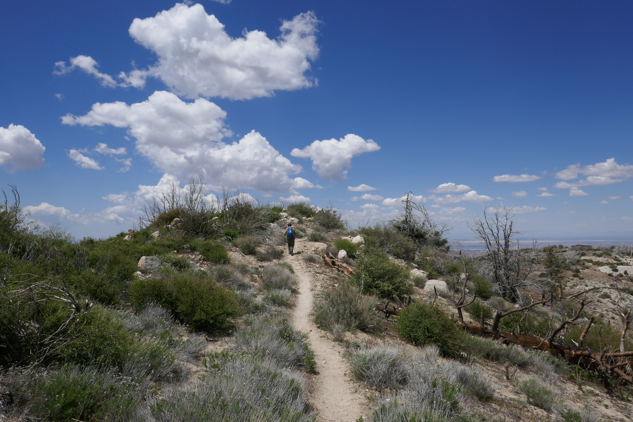
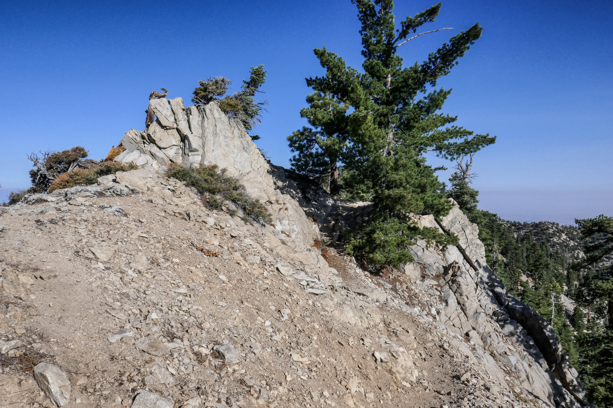
We took the trail from Buckhorn off the ACH climbing south through tall stands of Jeffrey Pine, Ponderosa Pine and Incense Cedars. This section took a hit from the Bobcat fire in 2020, and there are many charred trees, but the trail is still beautiful nonetheless. The vanilla smell of Jeffrey pines and dry sand along the trail was familiar and welcoming. I felt a sense of comfort. All worries and troubles from the past year were swept away on the fresh mountain air as we stepped onto the trail and began our climb. Once we reached the saddle on Waterman’s east ridge, we enjoyed the spectacular views down into Bear Canyon and out to Twin Peaks. Wildflowers were still blooming along the ridge. We took a short break before heading westward and up to the summit where we sat amongst the large rock formations and enjoyed our lunch. I reminisced how one year on New Year’s day we sipped champagne from the rocks and watched the stealth bomber fly over from the Pasadena Rose Parade. This mountain has always held special meaning to us and the San Gabriel High Country will always be one of my favorite sections of the Angeles.

Click “Read More” below to view more photos from this hike.

Read More

San Gabriel Peak, 3 miles RT, 1,030' +/-, Max Elevation 6,161', October 13, 2019

San Gabriel Peak, 3 miles RT, 1,030' +/-, Max Elevation 6,161', October 13, 2019

This weekend we did a late afternoon/early evening hike up to San Gabriel Peak. It was a full moon and I wanted to watch the sunset from the forest and see the moon come up over the San Gabriels. We started the hike from Eaton Saddle and through the Mueller Tunnel. When we reached Markham Saddle, we took the trail towards San Gabriel Peak. I’d forgotten how steep and rugged it is. The views along the way were wonderful. We took a short break at the top, enjoyed the views and then started back down. The sun was beginning to set and it would soon be dark. When we arrived back at Eaton Saddle, we saw a HUGE harvest moon coming up over Mt. Baldy. It was such a beautiful site! It was a short, but sweet evening.

Read More

Jackson Lake, Boy Scout Trail, 7 Miles RT, 1,378' +/-, Max Elevation 7,462', Camping Table Mountain, June 1 and 2, 2019

Jackson Lake, Boy Scout Trail, 7 Miles RT, 1,378' +/-, Max Elevation 7,462', Camping Table Mountain, June 1 and 2, 2019

This weekend was our first camping trip of the season! It was time to pull all our gear out and get familiar with it again since we’ll be backpacking the Mt. Whitney trail this year. I love camping. It’s so nice after a day of hiking to be able to build a fire and sleep out under the stars. We headed out of the gloomy cloud covered city up to sunny Wrightwood. There were, however, some scattered storm clouds hanging around, but the rains held off and the clouds passed us by. Our hike today started at Jackson Lake. There were people here fishing and families picnicking. We got on the Jackson Lake trail to the Boy Scout Trail. There’s plenty of shade on this trail as you pass through a forest of beautiful black oaks and towering pine trees. I’d like to come back here in the fall when the leaves are changing. It’s a lovely trail and we didn’t see another person. The Boy Scout Trail eventually ends at a junction for two service roads. You can head southwest on the Pinyon Ridge Truck trail, or southeast on service road 3N26. This road winds around the mountain as it climbs upward with nice views of Mt. Baden-Powell which is still covered in snow at the top. The road eventually takes you to a junction for the PCT, so we headed north here to loop back to the Jackson Lake Trail. We passed about 6 thru hikers on this section heading towards Baden-Powell. Hope they all made it up safely with the snow. It was about 2:30 pm when we got back to the trailhead and headed to camp at Table Mountain. After we set up camp, we went into town and brought back some Grizzly Burgers from the Grizzly Cafe. That’s the nice thing about camping at Table Mountain. You’re about a 10 minute drive from food! Why cook when you can get a burger to go, right? As the sunset and the weather cooled down, we built a fire, toasted marshmallows and enjoyed the outdoors. We had a peaceful night and slept comfortably under the stars. The next morning welcomed us with a beautiful sunrise and birdsong. We had breakfast and then headed home. The weekend was way too short, but I’m so grateful for the times we have like this when we get to be away from the city, traffic, electronics, etc. and enjoy the beauty of the forest.

Read More

Pacifico Mountain from Mill Creek, 14 miles RT, 2,316' +/-, Max Elevation 7,124', May 12, 2019

Pacifico Mountain from Mill Creek, 14 miles RT, 2,316' +/-, Max Elevation 7,124', May 12, 2019

What a beautiful mountain. There are so many blooming wildflowers this time of year. We did this hike last year in June and the weather was very hot. This time the weather was still warm, but definitely not as bad. Again, just as last year, we saw very few people other then the PCT thru hikers passing by on their way to the Sierras. We put in quite a lot of mileage and the day was made even longer by my stopping to take photos every few minutes. The best hikes are always the ones where I take my time and don’t feel like I’m in a rush against the clock or in a big hurry to reach the summit. Now that we’ve been hiking for a few years and have hiked many of these mountains, I don’t feel such an urgency to summit and I’m taking more time to stop and really appreciate and enjoy the beauty of my surroundings. Even though Pacifico Mountain was hit hard in the 2009 Station Fire and there’s still a lot of visible damage along the route, it’s a very pretty hike. The area is incredibly beautiful with great vistas and it is full of flowers and wildlife. In fact, we can in very close proximity to a rattlesnake towards the end of the hike and only about a half a mile away from the trailhead. We didn’t see the snake, but we did hear the warning rattle. She must have been alongside the trail hidden where we couldn’t see her. It’s amazing how they can disguise themselves. As we climbed up the mountain, the trail changed from charred trees to beautiful Jeffery Pines. We had lunch at the campground on top of the summit. It would be so nice to camp here sometime. There were a good number of ravens circling and I saw several species of butterflies including painted ladies, swallowtails and duskywings. We spent good amount of time at the top before leaving. There was no one there but us. I scouted around the big boulders to see if I could find the official USGS marker, but I still couldn’t locate it. I’ll check again next time we’re here. It was a really nice day.

Read More

Eaton Saddle, Mt. Lowe Road, Mt. Lowe Trail Camp, Tom Sloan, Mt. Lowe East, 6.4 Miles RT, 1,434' +/-, 5,421' Max Elevation, April 21, 2019

Eaton Saddle, Mt. Lowe Road, Mt. Lowe Trail Camp, Tom Sloan, Mt. Lowe East, 6.4 Miles RT, 1,434' +/-, 5,421' Max Elevation, April 21, 2019

The weather is still cool so I’m trying to make the best of the front range before it gets too hot. Today we drove up to Eaton Saddle with no specific plan in mind since there are plenty of routes you can take to make a great hike. We hiked up the Mt. Lowe Road through the Mueller Tunnel which experienced an avalanche over the winter, but some of the rocks were cleared so you can get around it safely. At Markham saddle, we decided to continue down the Mt. Lowe Road to Mt. Lowe Trail Camp and the ruins of Ye Alpine Tavern where we’d take a break and enjoy the ham and cheese croissants we’d picked up from the donut shop before starting our hike. I really love this area and enjoy walking the Mt. Lowe Fire Road. The views are great down into Bear Canyon and you can really see just how rugged the San Gabriels are. As we hiked the sun was trying very hard to break through the clouds, but we were soon engulfed in them as they wrapped around the mountain and our views disappeared in a heavy mist of white. When we reached the junction with the Tom Sloan Saddle trail, we branched off to explore it for about a quarter mile. It descended steeply and since we didn’t want to lose too much elevation, we decided to save that adventure for another day. I was really enjoying being surrounded by all the cloud cover. When we arrived at the Mt. Lowe Trail Camp, I noted that there was water flowing. This is the first time I’d seen it there. There were a few people enjoying the solitude of the camp, and we stopped for a while to appreciate the silence and eat lunch. I pulled out the map while we were eating to check out the Mt. Lowe East Trail. It would be a shorter, but steeper route back, so we decided to explore it. We got on the trail and began climbing up the switchbacks on Mt Lowe’s southern slope. There were some loose rocky, sections that were narrow and exposed so we had to be careful on those, but nothing too terrible. At one point, two mountain bikers almost collided into us as they were racing down the mountain on the switchbacks that didn’t give them much visibility to see what was around the corner. Thankfully, they saw us and we moved to the side so they could continue their way down the mountain. I worked up a pretty good sweat climbing up, but soon we reached the junction with the summit trail to Mt. Lowe. I considered continuing up since we were already here, but then we both decided since there would be no views today, that we’d just head back to Eaton Saddle and enjoy an early day.

Read More

Santa Anita Canyon to Mt. Wilson, 14.5 miles RT, 4,426' elevation +/-, 5,712' max elevation, April 1, 2019

Santa Anita Canyon to Mt. Wilson, 14.5 miles RT, 4,426' elevation +/-, 5,712' max elevation, April 1, 2019

I decided to take a vacation day on Monday so I could go hiking. We headed to Chantry Flats, but we weren’t sure whether or not we wanted to do a longer, more strenuous hike to Mt. Wilson or a shorter loop. We figured we’d decided when we got to the junction at Sturtevant Camp. Santa Anita Canyon was exceptionally beautiful today. There was so much water flowing in the creek. We took the Lower Winter Creek Trail that climbs up along the side of a rocky cliff to the top of Sturtevant Falls. The water was rushing strong and it looked awesome! As we hiked along the trail, we saw so many cascading pools of water. When we reached the junction near Sturtevant we made the decision to do the longer route to Mt. Wilson. I figured why not. I’d taken the day off and had no other place to be. As we started up that first steep mile, I was almost starting to regret my decision. My body was tired, but I didn’t want to turn around. We’d done this route last year, and I remember I really enjoyed it. We slowed up our pace which made it a little more bearable. It was a fun climb! Lots of beautiful scenery along the way. But I was very happy to reach to top because all I kept thinking about was sprawling out at one of the tables at the Cosmic Cafe and eating a ham and cheese croissant my husband had picked up at the donut shop before our hike! Once at the top, we had a nice rest. I took my hiking boots off to give my feet a break too. After we were finished refueling and recharging, we began the 7 mile descent back down the mountain. We took the Mt. Wilson Trail where you can still see quite a bit of fire damage to the Mt. Wilson Toll Road. There had been an avalanche since the last time we hiked on this road, and there were huge fallen boulders strewn across it. They were easy enough to get around, and I wondered what it must have sounded like when they came crashing down. We then reached the junction for the Winter Creek Trail and continued the long, steep descent on the switchbacks until we reached the bottom of the canyon. There were a lot of downed trees to hop along the way and there was also some trail erosion. The trail was still in good shape, but it does need a little TLC from the wonderful volunteers who help keep these trails passable so we can enjoy them. My knees and feet were getting tired, but the Winter Creek Trail is just so pretty. The final part of the hike was the grueling slog up the concrete road leading back to the parking lot. It seems to go on forever and it is steep! I was sweaty and tired by the time we got back to the trailhead, but it was so worth it. It’s been a while since we did any long, hard days on the trail so it felt really good to get out there and enjoy it!

Read More

Griffith Park: Wisdom Tree, Burbank Peak, 1.7 Miles RT, 761' +/-, 1,690' Max Elevation, March 18, 2019

Griffith Park:  Wisdom Tree, Burbank Peak, 1.7 Miles RT, 761' +/-, 1,690' Max Elevation, March 18, 2019

Since I began hiking in Los Angeles, I’d always seen photos of the Wisdom Tree. But since I’d never really been interested in city hiking until now, I never considered hiking up to see him for myself. He’s kind of a celebrity to Los Angeles city hikers. There’s a huge trunk that sits underneath the tree where hikers can leave their “Wisdom Tree Wishes” in the hopes they’ll be granted. This tree is the only tree that survived the 2007 Hollywood Hills fire. Now that our days are getting longer, there’s more time for hiking on weekdays after work. We decided to make the short climb up Burbank Peak where the famous Wisdom Tree is located. This is a very popular trail and there was a consistent flow of all kinds people going up and down the entire time. In front of us, a girl who was wearing only chucks and hiking with a handbag was slipping and sliding on the rocky trail trying to make her way up. She finally realized that this may not be the best idea and asked my advice on whether or not she should continue. I politely let her know it would probably be better to come back another day with a pair of hiking boots. She took my advice and turned around. I felt relieved she did so that she wouldn’t twist an ankle. The climb up was a lot of fun. It was a warm day and I worked up a decent sweat. As we made our way to the top, I saw a few people trying to come down on the rocks wearing sandals. Yikes. In just a short time we reached the top and the Wisdom Tree came into view. I walked up to him, made my introduction and then explored all around the summit taking in the 360 degree views of Burbank, Griffith Park, DTLA, Warner Bros. Studios, Universal Studios and the surrounding mountain ranges. To the east, there was a trail to continue on to Cahuenga Peak and Mt. Lee. We’ll try that one another day. After taking it all in, we carefully began our descent down the rocky trail. Now when I look up at the Wisdom Tree which I can see from the studio where I work, I can finally say that I have met him in person.

Read More

Griffith Park: Mt. Hollywood, Captain's Roost, Mt. Chapel Trail, Mt. Lee, 9 Miles RT, 2,110' +/-, 1,708' Max Elevation, March 17, 2019

Griffith Park:  Mt. Hollywood, Captain's Roost, Mt. Chapel Trail, Mt. Lee, 9 Miles RT,  2,110' +/-, 1,708' Max Elevation, March 17, 2019

We spent another day exploring Griffith Park. Our plan was to hike the North Trail from Mineral Wells Picnic Area and from there take the Mt. Chapel Trail to watch the sunrise from Mt. Lee which is where the Hollywood Sign is located. This is a non-traditional route to the sign, and I had not been able to find much much information about the Mt. Chapel Trail. We got started around 5:30 am and saw a couple of coyotes scavenging the picnic area for leftover food. As we hiked up, the city below looked really pretty. The lights were twinkling and there was a soft, warm wind blowing which made it seem kind of surreal. Up ahead I noticed the orange glow of an eye reflecting in the light of my headlamp. I wasn’t sure what kind of animal it was until I got closer and realized it was a little bird. It seemed strange to see a bird just sitting in the dirt and there was another one not far up ahead. Later, I did some research and learned that these nocturnal birds are called Common Poorwills. We continued up the hill until we reached the base of Mt. Chapel. It was about 20 minutes before sunrise, and at this point the wide trail turned into a rocky, narrow footpath hugging the hillside. We didn’t get too far on this when we realized we’d have some rock scrambling to do. I wasn’t comfortable scrambling rocks in the dark with only the light of our headlamps, especially since I didn’t know much about this trail. To play it safe, we backtracked and opted to see if we could make it to Mt. Hollywood for sunrise instead. We could always check out the trail again later when there was more light. We had about 15 minutes to reach our Plan B destination, and we made it there just in time! There were already a number of people on the summit ready to enjoy the sun coming up over Los Angeles. It was lovely. We then headed down to Captain’s Roost where you can find the “hidden palm trees” that you see in so many photos of Griffith Park. It’s just a short distance from the Mt. Hollywood summit, and it’s a great place for a photo op with it’s beautiful garden overlooking the city. From there, we continued our journey and headed toward Taco Peak. Taco Peak is a just small bump, but the climbing was a bit slippery due to all the loose little pebbles. The views at the top were nice, and from what I understand, there used to be a tea house here. After a quick snack break, we headed back towards Mt. Chapel to check out the Mt. Chapel Trail again now that there was daylight. After surveying the scrambling situation and some encouragement from my husband (I’m not a fan of rock scrambling), we made our way across the rugged trail over to Mt. Lee. I admit the rugged trail was a lot of fun and the views from the ridge were probably some of the best I’ve seen yet in Griffith Park. By this time the sun was warming things up and there were a lot of Painted Lady butterflies fluttering around the wildflowers. Eventually, the Mt. Chapel Trail intersected with Mt. Lee Drive and we met up with the crowds making their way up to enjoy the views from the summit of Mt. Lee and the back of the Hollywood sign. It was actually really fun seeing the Hollywood sign up close. I’ve lived here for so long now and never made it a point to go see it. But we didn’t stay very long since there were lots of people on top jockeying for a good view and the perfect photo. Even so, I would definitely recommending seeing the sign at least once just as long as you know what to expect as far as the amount of people you’ll be sharing the views with. After leaving Mt. Lee, we scrambled our way back across the fun Mt. Chapel Trail and back the way we came on the North Trail and to Mineral Wells. We put in about 9 miles. I am really enjoying exploring this park!

Read More

Griffith Park: Skyline Trail, Mineral Wells, Bee Rock, North Trail, 7.9 Miles, RT, 1,647' +/-, March 10, 2019

Griffith Park:  Skyline Trail, Mineral Wells, Bee Rock, North Trail, 7.9 Miles, RT, 1,647' +/-, March 10, 2019

Today we headed back to Griffith Park again and this time accessed the trails from the north side. We didn’t have to get up as early to beat the crowds today, and we had much more solitude coming up from this direction. We took the Skyline Trail to the Mineral Wells Trail. From there we followed it all they way to the Bee Rock Trail. What an interesting spectacle Bee Rock is from below! We made our way up the steep single track to the top of the Bee Rock where the views, even though fenced in, were excellent! From Bee Rock we hiked a short distance on Vista Del Valle and then picked up the North Trail. From the North Trail we connected back to Mineral Wells and then back to the Skyline Trail in a lollipop loop. I have to admit I really underestimated Griffith Park. It has a very extensive trail system, and there’s a hike for ever level. You can make a whole day out of it or just a few hours if you so choose. The only problem we ran into was that there are many use trails throughout the park, so it can get confusing as to which one to take. I found myself referring to my map quite a bit. At the end of our hike, we both agreed we are very lucky to have this wonderful park within a few minutes drive from our home. We’ll definitely be coming here more often in the future.

Read More

Griffith Park: Riverside Trail, Glendale Peak, Mt. Hollywood, 5.1 Miles RT, 1,155' +/-, March 9, 2019

Griffith Park:  Riverside Trail, Glendale Peak, Mt. Hollywood, 5.1 Miles RT, 1,155' +/-, March 9, 2019

Since moving to Burbank, we thought we’d give Griffith Park a try. It’s practically our backyard. The first time we went was last Sunday in the late afternoon where we did a short hike from Mineral Wells to Amir’s Garden. I liked it so much I wanted to come back and spend the whole weekend exploring more of the trails. I woke up early at 5 am on Saturday. I wanted to check out the southern end of the park and I knew accessing the trails from this end would be much more crowded. The parking was already starting to fill up when we arrived around 6:30 am. We hiked up the Riverside trail to the Hogback Trail to Glendale Peak and then the Mt. Hollywood Summit. The Hogback Trail was a nice workout! I really enjoyed this hike. It took a little getting used the being around so many people, but since it was a city hike, I knew that was to be expected. We had great views of DTLA and the hills were beginning to bloom with all kinds of flowers. This is going to be a great go-to place for us for hiking, especially when we aren’t able to make it up into the forest or even on a weeknight after work. After the hike today, we both agreed we wanted to come back and do some more exploring tomorrow.

Read More

Upper Las Virgenes Canyon Open Space Preserve, 4.8 Miles RT, 594' +/-, 1,404 Max Elevation, February 18, 2019

Upper Las Virgenes Canyon Open Space Preserve, 4.8 Miles RT, 594' +/-, 1,404 Max Elevation, February 18, 2019

There have been a number of rock slides in our local forests due to heavy rain and snow, so we decided to stick to lower ground and explore Upper Las Virgenes Open Space Preserve in Calabases. I’d see pictures of this place with its rolling hills, grassy meadows and majestic oak trees, but I never had the opportunity to visit and right now, it is so incredibly green! This area is a habitat for the San Fernando Valley Spineflower and the endangered Red-Legged Frog.

We started our hike at the Victory Trailhead. As soon as we left the parking area, I felt like I was in a movie set for “The Sound of Music” This place makes you feel so far away from LA, but it’s quite a different feel then the wilderness hikes we are so used to doing. We did an easy 5 miles on the Lasky Mesa Loop. It was a pleasant walk with just a little bit of up and down. We saw quite a few dogs on this trail too. I’m always happy to see people out hiking with their pups. It was a nice change of pace, and I was grateful to be able to see this location while it’s looking so vibrant. In the summer, the hills will lost their green radiance and turn to earthy brown.

Read More

Josephine Peak, 8 miles RT, 5,558' max elevation, 1,866' +/-, January 13, 2019

Josephine Peak, 8 miles RT, 5,558' max elevation, 1,866' +/-, January 13, 2019

My favorite part of the hike to Josephine Peak are the spectacular views. It’s a steady 4 mile climb to the peak, and today we had a nice, clear day since it had just rained. As we travelled up the fire road from Clear Creek Station just off Angeles Crest Highway, we could smell the eucalyptus trees and the yerba santa. It was even more fragrant today since it had just rained. I’m not quite sure how the eucalyptus trees got here since they’re not native, but they sure do smell nice. As we continued hiking up the trail, I started to get some great photo ops. Strawberry Peak looked quite impressive and we could see a dusting of snow covering the mountaineer’s route. We also had a nice, clear view of DTLA. The views went out all the way to the ocean. To the north, the high country was covered in fresh snow; Waterman, Baden-Powell, Twin Peaks, etc. As we neared the summit of Josephine, we crossed over a bit of snow ourselves. When we arrived at the peak, the views were even more incredible. The last time we were here we were shrouded in clouds so we didn’t get the 360 degree views that we had today. I took advantage and snapped away with my camera. It was absolutely lovely. After spending some time at the summit and greeting a few fellow hikers who’d come to enjoy the day as well, we decided it was time to begin our descent. The clouds started to roll in as we hiked back down the mountain, but we didn’t see any rain. It was an absolutely perfect day.

Read More

Mt. Pinos Snow Hike, 3.8 miles RT, max elevation 8,848', 515' +/-, December 30, 2018

Mt. Pinos Snow Hike, 3.8 miles RT, max elevation 8,848', 515' +/-, December 30, 2018

Today was a nice, low key snow hike around Mt. Pinos.  The weather was predicted to be in the upper 30s with wind gusts up to 30 mph.  We put on our layers and headed to Los Padres National Forest, which is just about an hour and thirty minute drive from Burbank.  We arrived at the Nordic Base around 9:30 am. This is actually a lot later then I usually like to be on the trail, but since this was going to be an easy day with not much mileage to cover, I didn’t mind sleeping in and waiting for the weather to warm up a few degrees.  Los Padres is absolutely beautiful in the snow. There was about 2 to 4 inches on the ground. We hiked the trail to the junction with the Vincent Tumamait Trail. The wind was pretty strong on the exposed switchbacks, and we did not continue on to Sawmill Mountain as we’ve done in the warmer months.  I took a lot of photos of the twisted limber pines in the snow and enjoyed the views and the crisp, winter air before heading back. It was a perfect winter day and great hike to close out the year.

Read More

Devil's Chair, 6.7 miles RT, 1, 260' +/-, 5,396' max. elevation, December 27, 2018

Devil's Chair,  6.7 miles RT, 1, 260' +/-, 5,396' max. elevation, December 27, 2018

I love the hike to Devil’s Chair. We did it in October of 2017 and it’s a beautiful part of the San Gabriels hidden away to the far north. The geological formations that have been formed throughout the years by the San Andreas and Punchbowl Faults are an incredible spectacle to witness firsthand. This area is also a transition zone between high desert and subalpine, and it’s interesting to see how the plants change as you travel the undulating trail. This time it seemed the trail was a bit more eroded in sections then the last time we hiked it, but it was still easily passable without being unsafe. As we approached the Devil’s Chair we descended the switchbacks and navigated the over narrow, rocky cliffs. Thankfully, there’s a metal fence put in place here that allows you to go all the way out to the edge. Otherwise you would not be able to hike here. The views from the Chair were spectacular. Once we’d taken it all in, we climbed back up and had a quick snack break before starting our return. The clouds were starting to roll in and it looked pretty chilly up in the higher elevations on Pleasant View Ridge and Mt. Lewis. The temperature dropped to about 43 degrees as we made our way back and the wind kicked up making it a chilly end to a beautiful winter day.

Read More

Warm and Cozy on Table Mountain, October 7 & 8, 2018

Warm and Cozy on Table Mountain, October 7 & 8, 2018

We hiked along the PCT in Wrightwood from Inspiration Point and across Blue Ridge to kill time before checking in at our campsite at Table Mountain. This section of the PCT has great views of Mt. Baden-Powell and Mt. San Antonio (aka Mt. Baldy). It passes by Mountain High Ski Resort and continues on past the Blue Ridge Campground. Some of the oaks were starting to change color, and it finally felt like fall. We did just over two miles on the trail before it was time to head to camp and get set up so we could settle in and enjoy the evening.

The weather in Wrightwood was chilly! I knew we’d be in for a cold night, but I was looking forward to snuggling up inside the tent in our sleeping bags. After we made camp, we headed into town to pick up a pizza and bring it back to camp for dinner. No point in cooking when you have a pizza shop 10 minutes away! Wrightwood is such a cute little town. It’s a nice change compared to the chaos and sprawl of Los Angeles. All the shops were decorated for Halloween and I even spotted a pumpkin growing outside the Wrightwood Market. As we walked around town waiting for the pizza, I felt that warm and cozy feeling I used to get growing up in Pennsylvania when the seasons would change from summer to fall. This is exactly how it should be this time of year.

When we arrived back at camp, we got the fire going right away. The autumn days are getting shorter and it wouldn’t be long before sunset. We spent the rest of the evening enjoying each other’s company and the warmth of the crackling fire. As the daylight faded and darkness set in, the night sky filled with endless stars. We were almost ready to call it a night when we noticed a bright white light appear in the sky. We watched it as it continued to travel in a southwest direction until finally disappearing. Neither of us knew what it was, but guessed it might have been a comet or some sort of rocket. We didn’t find out until we got back to the city and had cell service that it was, in fact, the SpaceX Falcon 9 rocket launch. What a sight to see from on top of a mountain in the middle of a forest!

The next morning we were in no hurry to get up from our warm sleeping bags. We slept in until well after sunrise. When we did finally get up, we built a fire to keep warm in the chilly morning air, then made coffee and breakfast. There was no rush to be anyplace else, so we took our time and later did a walk around the campground and enjoyed the views from high up on the mountain before it was eventually time to check out and head back to civilization.

Read More

Mt Lowe, 3 miles RT, 5,604' Max Elevation, 548' +/-, September 30, 2018

Mt Lowe, 3 miles RT, 5,604' Max Elevation, 548' +/-, September 30, 2018

My husband and I did a sunset hike on Mt. Lowe this past Sunday. We drove up to Eaton Saddle, followed the Mt. Lowe Fire Road through the Mueller Tunnel to Markham Saddle and then picked up the trail to the Mt. Lowe summit. I really like this area a lot. There’s never very many people and you get some great views of the rugged San Gabriels. The hike to the summit is a short one, but it was perfect for a day when we didn’t have time to do a long hike. The views are pretty great too. As the sun began to sink behind the Santa Monica Mountains to the west, we started to make our way back down the mountain. We reached Markham Saddle just 10 minutes before the sunset then stopped to enjoy the show as the light faded from orange, to pink and finally inky black. It was a little spooky coming back through the Mueller Tunnel in the dark, but the city below us lit up in a romantic, sparkling glow of lights. It was a great way to wrap up the weekend!

Read More

Red Box to Valley Forge Trail Camp, Gabrielino Trail, 6 Miles RT, 4,868' Max Elevation, 1,276' +/-, September 23, 2018

Red Box to Valley Forge Trail Camp, Gabrielino Trail, 6 Miles RT, 4,868' Max Elevation, 1,276' +/-, September 23, 2018

Today we hiked the Gabrielino Trail East from Red Box to Valley Forge Trail Camp with the option to continue on to West Fork and Devore Trail Camps if we felt up to it. With the cool morning temperatures and the trail covered in falling leaves from the towering oaks that surrounded us, it was finally starting to feel like fall. The first part of the trail descended the steep stone steps from the Red Box picnic area then continued down some exposed switchbacks. It wasn’t long until we were in the cool shade of the oaks following the trail along the South Fork of the San Gabriel River. The stream was dry at this time of year, but that didn’t stop the gnats from bothering us. Luckily, we were prepared and always have our bug nets with us which prevented the pesky insects from flying into our eyes.

On our route we passed by some cabins and the ruins of an old, stone chimney. After about two miles, we reached the junction for the Valley Forge Trail Camp that was marked with a sign at the spur. We descended the spur to the camp to check it out and see if it was a place we’d like to stay as a future backpacking trip. The camp was lovely with plenty of shade, fire rings, picnic tables and primitive bathrooms. We set up at one of the picnic tables and decided to stay a while. I made friends with a Steller’s Jay who invited himself to our breakfast table. It was a very nice day and we were thoroughly enjoying the peace and quiet! This hike along this section of the Gabrielino Trail reminded me a bit of Santa Anita Canyon sans the crowds. We will definitely be coming back when the weather cools down a bit more to hike the longer routes to West Fork and Devore Trail Camps, and perhaps enjoy an overnight stay.

Read More

Mount Williamson 8,214', 5 miles RT, 1,552 +/-, July 29, 2018

Mount Williamson 8,214', 5 miles RT, 1,552 +/-, July 29, 2018

The best time for hiking during the hot summer months is EARLY! I like to be on the trail either before sunrise or shortly after so I can enjoy my time on the trail before the day heats up. This is also the time of year when I like to stick to the high country or look for higher elevation hikes which are usually a bit cooler than those at the lower altitudes. Mount Williamson was the perfect hike for today; a short 5 miles from the Islip Saddle trailhead with a little bit of an elevation gain and a fun climb. The early morning sunlight was brilliant as we headed up the trail which starts off on the PCT. It wasn’t long before views of Mount Islip opened up to the south on the opposite side of the Angeles Crest Highway. The hike to Mount Williamson is a fun one. We did this last year in September and I really enjoyed it. The climb is mostly steady until you get closer to the top where you leave the PCT and the trail to Mt. Williamson becomes quite steep and rugged. Once at the top we had wonderful 360 degree views. It was only us on the summit so we took our time, had some snacks and after orienting my map, I spread it out and secured it with some rocks so I could use it to identify some of the surrounding features of the area. Many of the surrounding peaks were visible including Mount Lewis, Mount Baden-Powell, Throop Peak, Mount Hawkins and Twin Peaks to name a few. To the north I could see all the way out to the Mojave Desert and to the southwest I had a nice view of Williamson Rock, which was once popular with rock climbers until the area was closed off to protect the mountain yellow-legged frog. It was barley 9 am and already I could feel the sun starting to heat up the day, so we headed back enjoying our time on the trail and the sweet, vanilla fragrance of the Jeffery pines along the way.

Read More

Cucamonga Peak, 8,859', 12 miles RT, (4,252' +/-), November 23, 2017

Cucamonga Peak, 8,859', 12 miles RT, (4,252' +/-), November 23, 2017

Hit the trail early Thanksgiving morning to hike Cucamonga Peak.  We started up Icehouse Canyon at 5:30 am.  This was our third time up this trail to Icehouse Saddle which is a gateway to other trails including Cucamonga Peak.  It used to be a challenge, but it’s getting easier every time.  We entered the Cucamonga Wilderness just before the sun came up, and by 8 am we were at Icehouse Saddle.  We stopped for a snack, and it wasn’t long before other hikers arrived.  One of them was heading to the same destination as we were.  He was using the trail to train for other peaks.  After the break, we hopped on the next segment to Cucamonga Peak.  This is where the real hike began.  From here on out we were on much more rugged terrain with narrow sections, steep cliffs and rock scrambles.  It was one of those hikes where you really had to watch your footing.  Next came the switchbacks.  Some sections were all scree and talus.  It was a hard climb and my fear of heights being on a narrow ledge with loose rock and steep drops was starting to kick in.  I had to stop and take breaks to keep my zen.  I could see the peak, but it seemed a million miles away.  Up and up we went moving slowly, but making progress with each careful step.  We were less then half a mile away from the peak when we saw the young hiker we’d met at Icehouse Saddle coming down.  “Almost there.” he said.  “Take short steps and use your poles.”  After a few more switchbacks I spotted the marker for the spur trail leading up to the peak just ahead.  What a relief!  We made our final ascent up a steep but well buffed out section of trail.  Finally I saw the wooden sign, “Cucamonga Peak 8,859’”.  Whew!  That was rough!  The views from the peak were vast and sprawling overlooking the city and all the way out to the San Jacinto and Santa Ana mountain ranges.  We took a long break to rest our tired legs and celebrate Thanksgiving morning with yesterday’s leftover pizza!  On the way down my overactive mind calmed down.  Although I still had to be careful with my footing, I was in a much better headspace.  The hard part was over.  I was able to soak in the incredible views of the remote wilderness and enjoy the trek down this beautiful mountain.  The switchbacks seemed to go a lot faster on the way down, but we still had to negotiate our way through rugged trail back to Icehouse Saddle.  Once at the saddle, we still had about 3 miles to go to get back to the trailhead.  Luckily, the canyon is so pretty, it makes those last miles go quick.  We finished the hike (including our breaks and all my picture taking) in about 8 hours and 50 minutes.  We’ll be celebrating Thanksgiving day on Friday knowing we earned those extra slices of pumpkin pie!

Read More

Icehouse Canyon, Cucamonga Wilderness, Icehouse Saddle, Timber Mountain, 8,303' (3,325 +/-), 9.03 miles RT, August 27, 2017

Icehouse Canyon, Cucamonga Wilderness, Icehouse Saddle, Timber Mountain, 8,303' (3,325 +/-), 9.03 miles RT, August 27, 2017

Our destination today was to hike Icehouse Canyon through the Cucamonga Wilderness to Icehouse Saddle and then summit Timber Mountain via the Three Tee’s Trail.  Icehouse Canyon has quite a bit of history.  In the 1800s, there was an icehouse here that serviced Los Angeles.  The ice was brought down from the mountains by mules and sold door to door.  There was also a resort here that was built in 1880.  You can find more info. on all of this by searching it on Google.  It’s very interesting and really makes you appreciate the area in which you are hiking.  

Icehouse Canyon is a popular destination among Angelenos, so in order to beat the crowds, I was out of bed by 3:30 am, on the road and at the Old Baldy Ranger Station to collect our wilderness permits just after 5:30 am.  We arrived at the trailhead in the dark, but soon dawn broke and the sun rose to turn pitch black skies to moody blue.  As we began our ascent on the rocky terrain of the trail, we could hear the running creek off to our right.  It followed us through the canyon until we we reached the beautiful Cucamonga Wilderness where the trail opened up to towering trees.

Much of this trail is walking on rock and uneven terrain, so you have to pay attention here.  Then once you hit the switchbacks, get ready to party even harder!  It’s a slow burn all the way to the saddle but I guarantee the scenery will make you forget about your fatigued leg muscles.

The saddle is a junction for a number of different hikes.  Knowing the weather was going to heat up, we had already planned to summit Timber Mountain and be back down before it got too hot.

We took a short snack break at the saddle and then headed straight up the Three Tee’s Trail to summit Timber Mountain.  It was a short one mile climb, but that was no easy trek.  Once at the peak were were rewarded with the most beautiful mountain top covered in a forest of trees and huge, fallen pinecones.  I now understand why it’s called Timber.  We had a little lunch (sandwiches taste so good at over 8,000’), and took in the scenery until it was time to head back.  

With the cardio work out of the way, I could now enjoy myself by taking photos of… EVERYTHING.  Every which way I turned, it was a picture perfect landscape.  Coming back was definitely another challenge.  All those rocks we climbed up on had to be negotiated carefully on the way back down.  I could feel my quads working hard.  It was definitely something you had to pay attention to.  When we arrived back in the canyon, the sunlight peaked through the shady canopy of trees to create magical hues of green and gold.  Coupled with the sound of rushing water, I had to keep stopping and standing there saying, “Wow.  Oh Wow!  This is so pretty!”  

We passed quite a few people on the way back down, but not nearly as many as I had originally anticipated.  I guess not everyone likes getting up at 3:00 in the morning to beat the heat.  Personally, I would not have it any other way.  
 

Read More