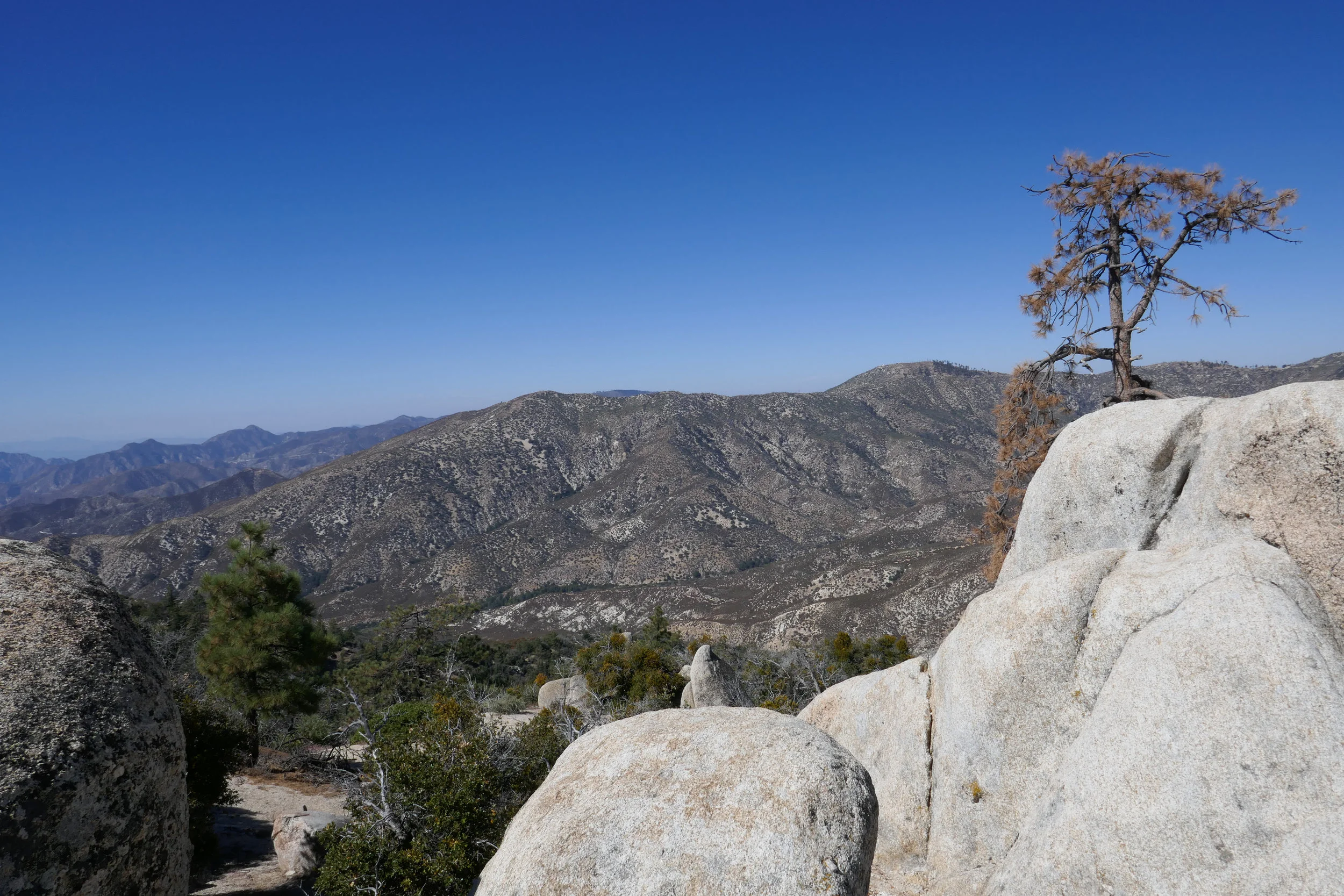
The beautiful Pacifico Mountain stands at 7,124’. It’s located in the central San Gabriels and the climb up on the PCT offers expansive views that sweep across the Antelope Valley and the Mojave Desert. This hike is about 6 miles one way. We’ve done it in its entirety in the past, but today our goal was to reach the PCT mile marker, break for lunch and then turn around and head back. With the shorter days, we wanted to make sure we were back down the mountain before darkness fell. We began the hike from Mill Creek Summit heading up the PCT. The aroma of chaparral was comforting and familiar and there was plenty of Manzanita on the trail. The charred trees burned in the Station Fire still held fast. As the trail hugged the north face of Mt. Pacifico, we passed large Spanish Bayonet. The trail is easy graded, but it is narrow and parts have now eroded since we were last here in 2019. We stopped to watch a group of ravens call and croak to one another as they danced and dived on the wind in tandem before landing on the precipitous ledges. I’ve always loved this hike because of those birds. The views to the PCT marker did not disappoint. The clouds decorated the blue sky only adding to the dramatic scenery of this incredible hike. After our break, we began making our way back. It was a nice way to end our time in the Angeles, until we return again next year.
Click “Read More” below for more photos from this hike.
Today we headed back to one of our favorite trails in Wrightwood, the Blue Ridge Trail. I was so happy to be back again and seeing the gorgeous golden color of the black oaks in autumn. We hiked the trail up to the campground and from there traversed northwest along the PCT. We soaked in the spectacular views of Mt. Baden-Powell and listened to the winds blowing through the big pines. I was in my happy place! Along the way we met a group of happy PCT hikers. We shared trail stories and then parted ways to continue to our own destinations. The day was simply perfect and my heart was filled with joy. At about three miles in we turned around and made our way back. We had another destination to cover that day and it was to our favorite diner in Wrightwood, the Grizzly Cafe!
Today we headed up the ACH with our maps, but no solid commitment to a particular trail. I really just wanted to bird watch. We ended up stopping at Cloudburst Summit and hiking down into Cooper Canyon. This is a beautiful section of Angeles National Forest. We’d hike this last year on the PCT in the summer. This time there was a lot of snow. The weather was perfect. It was cool, but the sun was warming. We took a break at Cooper Canyon Trail camp and both of us dozed off lying on top of a log. We saw lots of ladybugs near the stream and there were a lot of butterflies on the trail which was surprising since there was still so much snow on the ground. I was able to get a few photos of the butterflies and I believe they were California Tortoiseshells. My bird sighting list for today included plenty of Mountain Chickadees, Dark-eyed Juncos, Common Ravens and a new one to add to my list, a Clark’s Nutcracker. It was a perfectly beautiful day.
We had a nice hike on Mt. Hillyer this past Sunday. The weather was a bit on the warm side, and we started a little later than usual, but it was a lovely day. The last time we hiked this was on New Year’s Day and there was a cold wind chill. The ACH is still closed from the slide that happened in February. Now they’re saying it will be open at the end of October. It adds so much extra drive time to get up into the middle and high country of Angeles NF. Since it was a warmer day, the gnats were extra pesky. We had to wear our bug nets. One of the highlights of this hike in addition to the incredible boulder formations are the Coulter Pines on top of Mt. Hillyer. Their pine cones are about the size of my head! I brought along my tree identification book today and made use of it as we hiked. We put in a little over six miles today. It felt great to get back to the mountains after a few weeks away.
Today we made the drive to Wrightwood to hike the Blue Ridge Trail. We’ve been slacking the past couple of weeks since we got back from Mt. Whitney. The Blue Ridge Trail is a nice, mellow climb up to Blue Ridge in the welcoming shad of Oak and Pine. When we got to the ridge we decided to go a little bit further to enjoy the views. We hiked southeast along the PCT towards Guffy Campground and Wright Mountain for just a short while. It was a lovely day and much cooler than at the lower elevations. There are still plenty of wildflowers in bloom and the bees were buzzing all around them. Afterwards, we headed over to my favorite place to eat in Wrightwood, The Grizzly Cafe. It was a nice way to end the weekend.
We got up late today and decided to take our time getting anywhere. We weren’t really decided upon any one hike, so I stuffed my backpack with maps, downloaded a bunch of different trails onto the Garmin and headed up the ACH. The rock slide still hasn’t been repaired, so we had to take the detour to get to the high country. We then decided today would be a good day to hike Devil’s Canyon. The weather was cool, and I remembered last year when we did this hike in April there was lots of water flowing. I knew with all the rain and snow this year, there would be plenty of water now too. The trail hadn’t changed much. The views down into the canyon overlooking the San Gabriel Wilderness were beautiful. The trail could definitely use some love though. It was pretty brushy in some areas, and there were some trees down across the trail. There was also more erosion. Still, it was nothing too difficult to get around. We followed the creek most of the way and eventually reached the backcountry campsite. We saw a family on their way out who had spent the night. They had their kids who were carrying backpacks bigger then they were and two dogs. I asked them how their night was, and they told me it rained all night. We made our way over to this really great rock I found last year right next to the stream. It’s nice and smooth and shaped like a recliner. We got comfortable and ate our lunch (ham and cheese croissants from the donut shop... yum!). The sound of the running water was so relaxing and the clouds were billowing across blue sky. We took a nice nap until eventually the sky turned to gray and the sun was covered by the clouds. We packed up our stuff and began the hike up out of the canyon. I took a lot of photos on the way back. There were lots of wildflowers, and at one of the creek crossings there was a ton of ladybugs (and also poison oak). The cloud cover made the hike up and out pleasant since it kept us cool on the exposed sections of the trail. It was a very peaceful, relaxing day.
The weather is still cool so I’m trying to make the best of the front range before it gets too hot. Today we drove up to Eaton Saddle with no specific plan in mind since there are plenty of routes you can take to make a great hike. We hiked up the Mt. Lowe Road through the Mueller Tunnel which experienced an avalanche over the winter, but some of the rocks were cleared so you can get around it safely. At Markham saddle, we decided to continue down the Mt. Lowe Road to Mt. Lowe Trail Camp and the ruins of Ye Alpine Tavern where we’d take a break and enjoy the ham and cheese croissants we’d picked up from the donut shop before starting our hike. I really love this area and enjoy walking the Mt. Lowe Fire Road. The views are great down into Bear Canyon and you can really see just how rugged the San Gabriels are. As we hiked the sun was trying very hard to break through the clouds, but we were soon engulfed in them as they wrapped around the mountain and our views disappeared in a heavy mist of white. When we reached the junction with the Tom Sloan Saddle trail, we branched off to explore it for about a quarter mile. It descended steeply and since we didn’t want to lose too much elevation, we decided to save that adventure for another day. I was really enjoying being surrounded by all the cloud cover. When we arrived at the Mt. Lowe Trail Camp, I noted that there was water flowing. This is the first time I’d seen it there. There were a few people enjoying the solitude of the camp, and we stopped for a while to appreciate the silence and eat lunch. I pulled out the map while we were eating to check out the Mt. Lowe East Trail. It would be a shorter, but steeper route back, so we decided to explore it. We got on the trail and began climbing up the switchbacks on Mt Lowe’s southern slope. There were some loose rocky, sections that were narrow and exposed so we had to be careful on those, but nothing too terrible. At one point, two mountain bikers almost collided into us as they were racing down the mountain on the switchbacks that didn’t give them much visibility to see what was around the corner. Thankfully, they saw us and we moved to the side so they could continue their way down the mountain. I worked up a pretty good sweat climbing up, but soon we reached the junction with the summit trail to Mt. Lowe. I considered continuing up since we were already here, but then we both decided since there would be no views today, that we’d just head back to Eaton Saddle and enjoy an early day.
I decided to take a vacation day on Monday so I could go hiking. We headed to Chantry Flats, but we weren’t sure whether or not we wanted to do a longer, more strenuous hike to Mt. Wilson or a shorter loop. We figured we’d decided when we got to the junction at Sturtevant Camp. Santa Anita Canyon was exceptionally beautiful today. There was so much water flowing in the creek. We took the Lower Winter Creek Trail that climbs up along the side of a rocky cliff to the top of Sturtevant Falls. The water was rushing strong and it looked awesome! As we hiked along the trail, we saw so many cascading pools of water. When we reached the junction near Sturtevant we made the decision to do the longer route to Mt. Wilson. I figured why not. I’d taken the day off and had no other place to be. As we started up that first steep mile, I was almost starting to regret my decision. My body was tired, but I didn’t want to turn around. We’d done this route last year, and I remember I really enjoyed it. We slowed up our pace which made it a little more bearable. It was a fun climb! Lots of beautiful scenery along the way. But I was very happy to reach to top because all I kept thinking about was sprawling out at one of the tables at the Cosmic Cafe and eating a ham and cheese croissant my husband had picked up at the donut shop before our hike! Once at the top, we had a nice rest. I took my hiking boots off to give my feet a break too. After we were finished refueling and recharging, we began the 7 mile descent back down the mountain. We took the Mt. Wilson Trail where you can still see quite a bit of fire damage to the Mt. Wilson Toll Road. There had been an avalanche since the last time we hiked on this road, and there were huge fallen boulders strewn across it. They were easy enough to get around, and I wondered what it must have sounded like when they came crashing down. We then reached the junction for the Winter Creek Trail and continued the long, steep descent on the switchbacks until we reached the bottom of the canyon. There were a lot of downed trees to hop along the way and there was also some trail erosion. The trail was still in good shape, but it does need a little TLC from the wonderful volunteers who help keep these trails passable so we can enjoy them. My knees and feet were getting tired, but the Winter Creek Trail is just so pretty. The final part of the hike was the grueling slog up the concrete road leading back to the parking lot. It seems to go on forever and it is steep! I was sweaty and tired by the time we got back to the trailhead, but it was so worth it. It’s been a while since we did any long, hard days on the trail so it felt really good to get out there and enjoy it!
Today we set out to hike from Mill Creek Summit on the Pacific Crest Trail and up to the Pacifico Mountain Campground. I knew this mountain was a north face, and I had a feeling we might encounter some icy patches on the trail, but we decided to give it a go. I knew there would be some snow up at the campground after the recent rain, and I wanted to take advantage of that since we never know what kind of winter we’ll have here in Southern California. We were about two miles into the hike and we started to come across patches of hard packed ice. We had microspikes to slip onto our boots for traction, but if we were to continue, coming down would be sketchy. Neither one of us wanted to risk spraining an ankle, so we decided to turn around and head back. Since it was still early in the day, we drove to Charlton Flats, had some lunch and then drove up to Waterman Mountain which I knew would be reliable for a nice snow hike. It was about 12:30 when we started on the trail and I expected to see many more people hiking, but it was actually very quiet. Most of the snow play folks stayed on the fire road or over at the Buckhorn day use area and there were very few people hiking up the Waterman Mountain trail. The few people we past were hiking with dogs in tow, or rather I should say they were in tow of their dogs. That’s the one thing I love about hiking… seeing all the happy dogs on the trail. As we got higher up, we seemed to be the only people on the trail. The sky was gray with overcast clouds and the mountain seemed still and peaceful. It was around 2:15 when we reached the Twin Peaks junction which is about 3/4 miles away from the Waterman Mountain summit. At this point we both decided it was time to head back to make sure we returned safely before the sun set and the temperatures dropped and turned the melting snow to ice. We both went home satisfied after spending another beautiful day in our Southern California mountains.
Sunday was our first hike in about a month since my husband and I were busy moving most of November. Late Sunday morning we headed up Angeles Crest Highway with a bunch of maps, but no real commitment to any particular trail. As we passed by the entrance to Switzer Camp the overflow parking along the highway didn’t look too busy. We turned in and headed down to see how it was looking. Surprisingly, it wasn’t too packed for a weekend. Some of the oaks were still holding onto their color, so it was a nice treat since we didn’t get to experience much of the fall weather this year. The stroll along the Arroyo Seco was very pleasant, and we crossed the stream a number of times. I think the last time we hiked this all the way to Bear Canyon Trail Camp last March, I counted a total of 50-something crossings round trip. It was a beautiful day. Perfect hiking weather; a little chilly to start, but we warmed up as we kept going. On the cliffs we passed by the ruins of the old Switzer-land chapel and then descended down towards Switzer Falls. We decided to forgo the falls this time and continue on to the Bear Canyon Trail knowing there’d be lots of pretty cascades along the way and a lot less traffic. We hiked in as far as the junction where the two streams intersect, and then continued on a bit farther to where the going becomes less maintained. We stopped about a mile short of the campground this time. It was getting later in the day and we wanted to make sure we got back before the sun started to set. It was a nice way to ease back into the hiking routine again, and we could not have asked for a more perfect day.
My husband and I did a sunset hike on Mt. Lowe this past Sunday. We drove up to Eaton Saddle, followed the Mt. Lowe Fire Road through the Mueller Tunnel to Markham Saddle and then picked up the trail to the Mt. Lowe summit. I really like this area a lot. There’s never very many people and you get some great views of the rugged San Gabriels. The hike to the summit is a short one, but it was perfect for a day when we didn’t have time to do a long hike. The views are pretty great too. As the sun began to sink behind the Santa Monica Mountains to the west, we started to make our way back down the mountain. We reached Markham Saddle just 10 minutes before the sunset then stopped to enjoy the show as the light faded from orange, to pink and finally inky black. It was a little spooky coming back through the Mueller Tunnel in the dark, but the city below us lit up in a romantic, sparkling glow of lights. It was a great way to wrap up the weekend!
I had my mind made up about wanting to transition from day hiking to backpacking. Once I get my mind set on something, I obsess over it until it happens. After spending a couple of weeks doing research, I felt confident enough to head over to REI and make the investment. We spent the following day setting up camp in the living room and practicing packing our backpacks. Sunday morning (also my birthday), we headed out with all our new gear to Wrightwood to hike the Blue Ridge Trail. The Blue Ridge trail was a perfect trail to get a feel for the new packs with the additional weight we’d be carrying on a backpacking trip. I picked this trail because it’s well maintained, it’s not too steep and there is no scree which makes it a great place for a worry free trial run. There’s also a bit of altitude (over 8,000’ at the ridge) and about 1,000’ of gain in two miles. Both of us carried over 20% of our bodyweight which slowed us down from our normal day hiking pace. But backpacking, to me, is a different mindset. It’s not about rushing to bag a peak or hiking to be at a certain place by a certain time. This is a quote from one of my hiking books that could not sum up how I feel about backpacking any better:
“Once you realize that the road is the goal and that you are always on the road, not to reach a goal, but to enjoy its beauty and its wisdom, life ceases to be a task and becomes natural and simple, in itself an ecstasy.” - Sri Nisargadatta Maharaj
I believe backpacking is going to take us on exciting new journeys into the wilderness and offer us amazing experiences that will make our lives even richer. In a few weeks, we’ll be setting up camp for the first time to enjoy our first overnight in the forest. I’m really excited about all of this and looking forward to many adventures to come!
The best time for hiking during the hot summer months is EARLY! I like to be on the trail either before sunrise or shortly after so I can enjoy my time on the trail before the day heats up. This is also the time of year when I like to stick to the high country or look for higher elevation hikes which are usually a bit cooler than those at the lower altitudes. Mount Williamson was the perfect hike for today; a short 5 miles from the Islip Saddle trailhead with a little bit of an elevation gain and a fun climb. The early morning sunlight was brilliant as we headed up the trail which starts off on the PCT. It wasn’t long before views of Mount Islip opened up to the south on the opposite side of the Angeles Crest Highway. The hike to Mount Williamson is a fun one. We did this last year in September and I really enjoyed it. The climb is mostly steady until you get closer to the top where you leave the PCT and the trail to Mt. Williamson becomes quite steep and rugged. Once at the top we had wonderful 360 degree views. It was only us on the summit so we took our time, had some snacks and after orienting my map, I spread it out and secured it with some rocks so I could use it to identify some of the surrounding features of the area. Many of the surrounding peaks were visible including Mount Lewis, Mount Baden-Powell, Throop Peak, Mount Hawkins and Twin Peaks to name a few. To the north I could see all the way out to the Mojave Desert and to the southwest I had a nice view of Williamson Rock, which was once popular with rock climbers until the area was closed off to protect the mountain yellow-legged frog. It was barley 9 am and already I could feel the sun starting to heat up the day, so we headed back enjoying our time on the trail and the sweet, vanilla fragrance of the Jeffery pines along the way.
Today we started out with a plan to do “just a short hike”. Well, by now I should know that it rarely ever works out that way. We didn’t feel like driving too far so we decided to stick closer to home and take a ride up to Eaton Saddle. We hiked up the Mount Lowe Road, through the Mueller Tunnel (which I think is absolutely amazing) and reached Markham Saddle. At that point we had several options to climb the peaks that we’d done before; Mt. Lowe, Mt. Disappointment, San Gabriel Peak or we could continue on the Mount Lowe Road. I pulled out the map to see where it would take us. It looked to be a little over four miles to reach the Mount Lowe Trail Camp and Inspiration Point (which we’d also been to before, but never from this direction). We decided to give it a go. What a great route! I’m so glad we did it. This area has so much history. Not only was this a very low stress, no cliff hugging ledges kind of hike, but it also had a lot of butterflies. After reaching Inspiration Point, we continued along the fire road past the crowd of people until we reached the junction to summit Muir Peak. I knew we’d have the peak all to ourselves along with the views to boot. My husband and I hung out up there for a while. I chased around the Chalcedon Checkerspot butterflies trying to get some photos while my husband talked on his HAM radio. There was a lot of California Buckwheat up on this peak, hence all the butterflies. I even got one to sit on my finger. The surrounding views were terrific; Pasadena and the city below, Mount Wilson, Occidental Peak, Mount Harvard, San Gabriel Peak, and Mount Lowe to name a few. After we were done enjoying having the place to ourselves, we started heading back. By this time it was getting pretty warm and much of the morning shade we had earlier was almost gone. Thankfully, we always come prepared with plenty of water and there was a nice, refreshing breeze every now and then to help keep us cool. As we hiked back, the road was buzzing with butterfly activity. There were plenty of Blues, Swallowtails, Chalcedon Checkerspots, Hairstreaks and I was also able to find and photograph the elusive Great Basin wood-nymph. As always, it was another great day to be in the mountains!
Today we did a short hike in the front range from the Grizzly Flat Trailhead past the locked gate along 2N79. 2N79 splits off and you can continue northwest to Grizzly Flat or you can follow it north and then east as it makes a turn towards Hoyt Mountain. The later was our destination. We’ve hiked this trail many times before because it’s a hot spot for several different species of butterflies. This was the first time we followed it all the way to Hoyt Mountain. The trail continues to climb until it reaches a saddle after just a little over two miles. Here there’s a split to continue on a rugged use trail up to the summit of Hoyt, or you can continue onto the very overgrown Telephone Trail which descends to Clear Creek. We climbed up on the use trail about halfway to the false summit and decided it was too overgrown and steep to continue. I was actually more interested in going back down to photograph all the Chalcedon Checkerspots that I saw at the base of the mountain. I photographed Chalcedon Checkerspots near this area last year, but this year there were so many that they were practically landing on me as I took my photos! It was about 9 am and the sun was really starting to warm things up. We decided to descend before it got too hot and finish up the hike with a visit to DISH in LaCanda for some hot coffee, eggs, bacon and my favorite... pancakes!
We wanted to try out a different route to Mount Baden-Powell, so we decided to start our hike from Dawson Saddle. It adds a little bit of extra mileage, but there are really great views along the route because much of this hike follows along the ridge once you reach the junction for the PCT. It's also less heavily trafficked then the route up from Vincent Gap. Since Baden-Powell was added to the Six Pack of Peaks Challenge, it's become increasingly popular. We actually only planned on hiking to Baden-Powell, but we had the time and decided to go up to Mount Burnham and Throop Peak which were close by. I should note that all of my photos were taken with my Android phone today. Somehow I managed to forget my camera which was a big disappointment because I love doing my photography along the way. I really enjoyed this route and trying out a new trail. After the hike we drove into Wrightwood for a bite to eat. On the way we passed by the trailhead at Vincent Gap and it was mobbed with cars! I couldn't believe how crowded it was. I was grateful we didn't go up that route today. Looks like we'll need to save the Vincent Gap route for a weekday when it's less busy. Baden-Powell is a lovely peak. It's also nice to say hello to the 1,500 year old Wally Waldron limber pine that sits on the ridge just below the summit. I'm sure he was pretty popular for photos today! It was another great day to be in the mountains!
We were due for a visit to the top of good old Mount Baldy, so I took the day off on Friday to do it. This was our 3rd time to summit this mountain, and it’s always a nice challenge. We took our usual route up on the Baldy Bowl/Ski Hut Trail with a short break once we arrived at the Ski Hut. Then on we went through the Baldy Bowl boulder field and up through the steep switchbacks making our way through the pine forest and the short reprieve at the saddle. Then it was onto the manzanita maze of use trails to find our way to the top. Thankfully, the markers are all still intact since the last time I was up in December which made finding the trail easier. About a half a mile from the summit we stopped to chat and take a breather with a fellow hiker named Karen and her beautiful chocolate lab, Frankie. For the rest of the way, Frankie became my hiking buddy as she went back and forth between Karen and I. I could feel her nudge my leg with her head from time to time as if to say, “Come on lady! Hurry it up!” Soon enough, my husband who was ahead of us reached the summit and I was not too far behind along with Frankie and a moment later, Karen. No one was at the top but us! It was beautiful! The weather could not have been more perfect; sunshine and a nice breeze. I wandered around the empty summit taking my photos then sat for a bit to have a bite to eat and and chat with Karen and a few other hikers who had arrived. Eventually, all of them including Frankie headed down the Devil’s Backbone. Octavio and I were the only ones on top of Mount Baldy for a while. How cool is that considering the amount of traffic this summit sees! Soon it was time to begin our journey back. Instead of going down the Devil’s Backbone which has been our usual route, we opted for a change of scenery and decided to head back on the Baldy Bowl/Ski Hut Trail. We’d never seen it in the opposite direction before and although it’s quite steep, we wanted to give it a go. So down we went. The trek down was much harder than it was going up and definitely much steeper then going down the Devil’s Backbone. Thankfully, the scenery is so beautiful, it kind of takes your mind off your aching knees! We slowly made our way down trying as best we could to be careful not to slip on the sections of loose rock. We also had to be mindful not to lose the trail going through the manzanita maze just before reaching the saddle, as I’ve heard stories of people going off trail here and ending up in the bowl where there’s wreckage from a plane crash and then they had to climb their way back out. Finally, we made it back to the ski hut. We took a break here to rest our legs. As we sat, a very bold Stellar Jay came up pretty close to me to scope out my food situation. What a bum! You can tell the birds and also the chipmunks up at the summit are spoiled from so many people hiking here and feeding them their snacks. After our last rest, we began the final descent. It felt so good when we got back to Falls Road and I looked back up at the mountain we had just climbed. I wondered, as I often do, how we even make it up such a steep climb. I guess somehow you just do! It was another wonderful day on a most beautiful mountain!
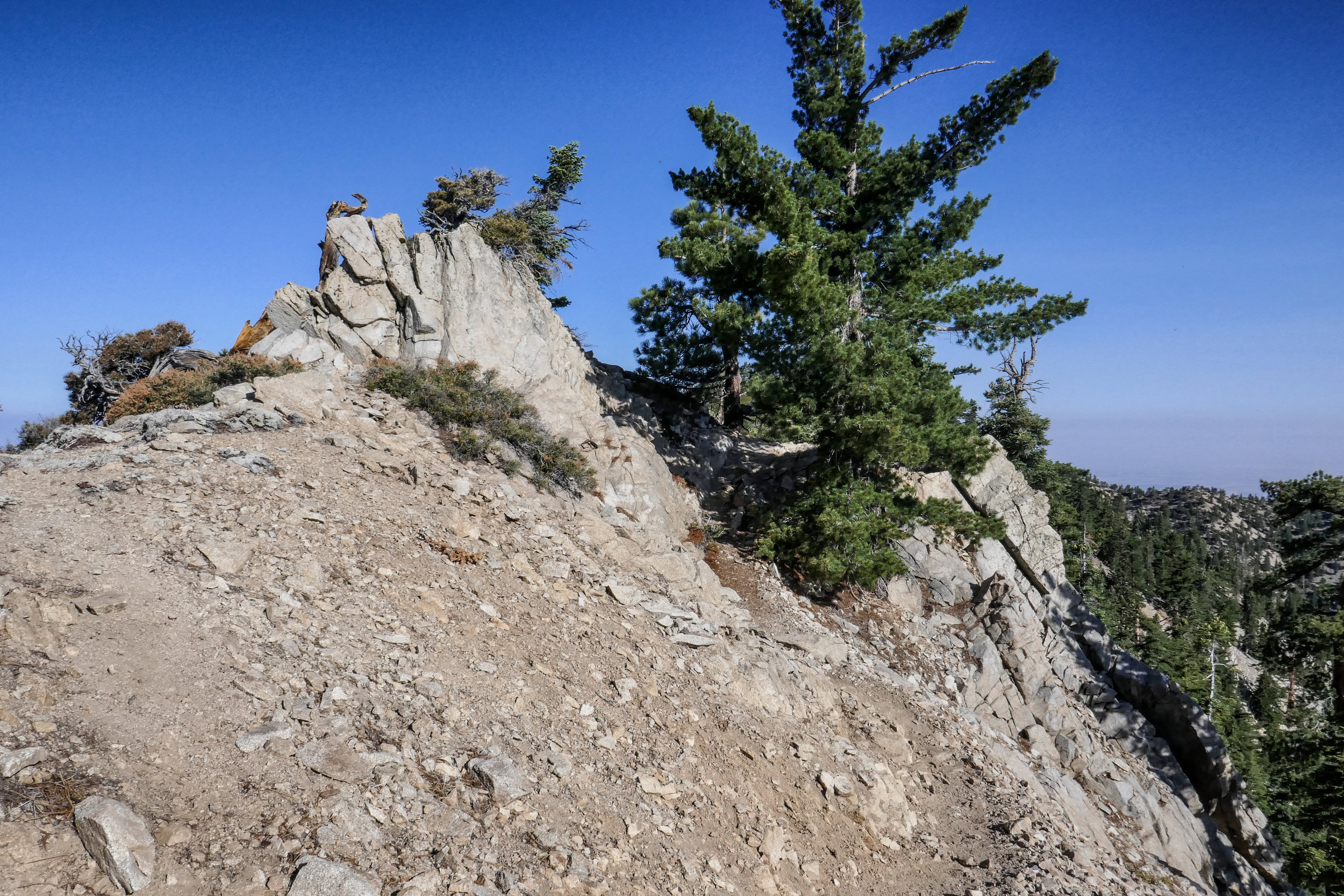
I was super excited to explore a new part of the Angeles National Forest this past Sunday! One of the first hiking books I’d ever purchased was “Trails of the Angeles” by the late John W. Robinson. This hike is hike #1 in his book. In addition, Casey Schreiner of ModernHiker.com, recently posted a trail report about this hike, making it sound even more appealing.
The trailhead is about an hour and 20 minute drive from our home and is in the northwestern section of the Angeles NF. It starts off on the PCT, and we did pass a number of thru hikers headed to the Sierras as we ascended the mountain southbound.
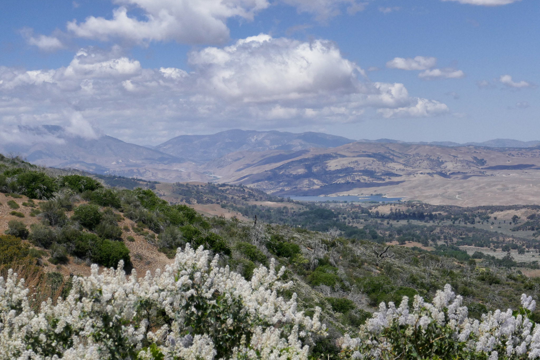
The first part of the trail took us up switchbacks that were surrounded by blooming ceanothus (wild lilac) as well as patches of yerba santa. As we made our way up, we had wonderful views of the Antelope Valley, the Ventura mountain ranges, the San Andres rift zone and the Tehachapis. It’s a very interesting contrast considering the mountain we were hiking on was so lush and green.
As we continued, we passed through an incredibly beautiful pine grove filled with purple lupines. Various wildflowers were numerous along the entire route. As we climbed upward, Liebre mountain turned into a sprawling oak savanna and the clouds began to roll over us as they made their way across the mountaintop. We reached a junction where the PCT headed east, but continued along the trail (which was now more of a fire road then a single track) to reach the highest point of Liebre Mountain. To find the high point which is marked with a wooden stake and a pile of large rocks, we had to leave the road and do a little searching. We stopped here to relax, have a snack and enjoy the scenery. We also did a some exploring around the top of the mountain before making our way back taking our time as we did. As we descended, the temperatures had warmed up a bit and there was more wildlife activity; lizards warming themselves in the sun and insects enjoying the wildflower blooms. I stopped for a while to get some photos of a Clearwing Hummingbird Moth nectaring on the yerba santa at about 4,300’. It was quite a sight! I’d never seen one of these before! This was a lovely hike and another great day to be in the mountains!
On the way back from Devil’s Canyon today, we stopped off at Grizzly Flat so I could take some butterfly photos with my DSLR. I don’t hike with my DSLR anymore because it’s too cumbersome on strenuous hikes. I also don’t want to ruin it when I need to climb up rocks or navigate through tall brush. I brought it along today just for this hike since it’s an easy one up a nice, wide trail. The sun was in and out so it was mostly cloudy, but the hike was very nice. There were lots of wildflowers in bloom, hence the butterflies were around them. I didn’t see a lot of activity today, but I did see a few as well as some other critters in the short time we were on the trail. One of these days I’d like to hike up this trail a little further although it’s hard when you’re searching for butterflies because you end up spending a lot of time just in one spot waiting for that perfect shot!
It was 6:30 am Sunday morning and we were on the trail headed to Trail Canyon Falls, a beautiful waterfall cascading 30 feet down into a rugged canyon. What this hike lacks in distance, it makes up for in beautiful scenery. The trail to the falls winds through the canyon and crosses the creek several times before heading up to the top of the waterfall where you’ll have spectacular views looking straight down. If you’re feeling adventurous you can also descend a steep use trail where you can rock scramble your way down with the help of a rope tied to a tree to get to the base of the falls. Today the water was flowing beautifully, the wildflowers were blooming and butterflies were on the wing. Since we started so early, we shared the falls with only two other hikers. It was a very peaceful morning. As we headed back, I came upon a very hungry swallowtail who was so busy nectaring on Western Wallflower that he didn’t seem to mind me hovering over him with my camera to take some photos. Also, if you keep your eyes peeled, there’s a picnic table nestled away in the shade off to the side of the trail that makes for a great place for a snack break or even a picnic. We stopped there for a bite to eat before finishing up the hike. It was an absolutely perfect day with temperatures at about 65 degrees at 10:30 am when we arrived back at the trailhead.