Today we headed up the ACH with our maps, but no solid commitment to a particular trail. I really just wanted to bird watch. We ended up stopping at Cloudburst Summit and hiking down into Cooper Canyon. This is a beautiful section of Angeles National Forest. We’d hike this last year on the PCT in the summer. This time there was a lot of snow. The weather was perfect. It was cool, but the sun was warming. We took a break at Cooper Canyon Trail camp and both of us dozed off lying on top of a log. We saw lots of ladybugs near the stream and there were a lot of butterflies on the trail which was surprising since there was still so much snow on the ground. I was able to get a few photos of the butterflies and I believe they were California Tortoiseshells. My bird sighting list for today included plenty of Mountain Chickadees, Dark-eyed Juncos, Common Ravens and a new one to add to my list, a Clark’s Nutcracker. It was a perfectly beautiful day.
Read Morecreek
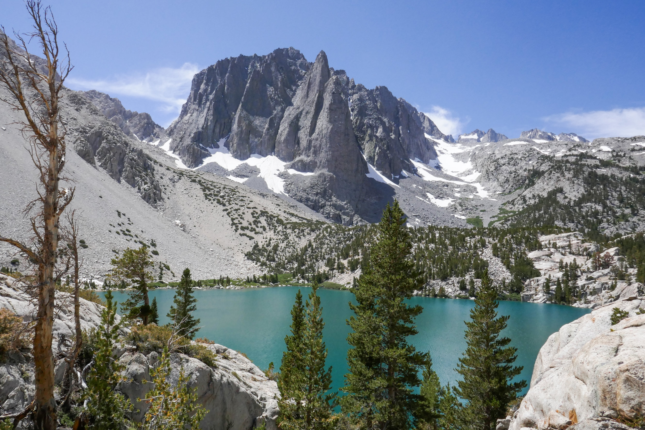
Big Pine Lakes, North Fork Trail, Eastern Sierra, 13.6 Miles RT, 2,385' +/-, 10,427' Max Elevation, August 19, 2019
Our hike to Big Pine Lakes in the Eastern Sierra was one of the most beautiful hikes I’ve ever been on. There are seven lakes total and on this day, we hiked to the first three via the North Fork Trail. Since we weren’t backpacking, I had much less weight to carry then when we were in the Eastern Sierra last month backpacking the Mt. Whitney Trail. Most of the Big Pine Lakes hike follows along Big Pine Creek. We were next to the beautiful rushing waters most of the day. Early in the morning when we first got on the trail, we saw two doe and a fawn crossing the creek. There were plenty of wildflowers and butterflies to enjoy throughout the day as well. I took my time on this hike and spent a lot of time taking photos of it all. When we reached lake one we saw Temple Crag (popular with alpine rock climbers) towering over the incredible turquoise waters. The turquoise color comes from the glacial powder of Palisade Glacier. I also saw some trout swimming in the lake. This was a wonderful hike. We had to do some work climbing up in elevation to get to the lakes, but it was well worth the effort because the scenery was spectacular.
Read MoreCottonwood Lakes, 14 miles RT, Max elevation 11,384', 1,660 +/-, Inyo National Forest, Eastern Sierra Trip, July 10, 2018
I woke up at 4:30 am excited to get started on our new adventure. We had a hearty breakfast and soon were on our way up Horseshoe Meadow Road to the Cottonwood Lakes Trailhead at 10,000’. I took my compass bearings, geared up and we were on our way by about 7 am. The trail enters the Golden Trout Wilderness and starts off on a leisurely stroll through the big pine trees. As we went along we started to gently descend. We followed along side a beautiful creek and made a few water crossings. The mosquitos were out in full force, so I was sure to break out the bug spray before becoming their early morning breakfast. We passed by lush green meadows dotted with wildflowers, corn lily and incredible views of large granite cliffs. Soon we entered the John Muir Wilderness. There was another creek crossing and more lovely meadows to enjoy before we came to the switchbacks. As we began to ascend our pace was slower than usual due to the high altitude. I did not mind stopping to take a few breaks so I could enjoy the views from above and take my photos. As we approached the top of the switchbacks, we could see some peaks coming into view. We passed a junction for Muir Lake and started to see the playful marmots poking their heads out waiting to see if we were going to give them hand out. The trail gently meandered through the meadow with a flowing stream and had incredible views of Cirque Peak and Mount Langley. It wasn’t long before the Cottonwood Lakes came into view. They were stunningly beautiful. We took a moment and sat in the shade to take a break, have a snack and enjoy the scenery, peace and quiet. We made our way to lake #3 and followed along its shore to a short climb up some switchbacks. On the other side we reached lakes 4 and 5. We felt a light breeze and could see the summer storm clouds rolling in closer, but I didn’t hear any thunder. We thought it was a good time to start heading back. We had quite a ways to go before reaching the end of our journey. As we made our way down the switchbacks we enjoyed another marvelous view of lake #3 from above. We passed a man with his two sons who were fishing, but he said they hadn’t had any luck. As we made our way back to the trailhead, I could feel some light precipitation. The cool raindrops on my skin felt refreshing after a long day and the smell of summer rain mixed with the pine was intoxicating. We got back to the trailhead around 3:30 pm and clocked about 14 miles. It was my first time hiking for that long at such a high altitude and I was both tired and exhilarated at the same time. It was an incredible experience. The Eastern Sierra has so much to offer. I have fallen in love.
Read MoreDevil's Canyon, 5.3 miles RT, 1,357 +/-, April 15, 2018
We’ve been doing a lot of canyon hikes lately. Devil’s Canyon was another one I’ve had on my “to do” list since we’ve been driving past it on the way to other hikes. The trail takes you down into the rugged San Gabriel Wilderness. It follows a babbling brook into the heart of Devil’s Canyon where it opens up to flat, sandy trail next to sparkling pools, cascades and smooth boulders that make a great place to have lunch. There’s also a primitive backcountry campground that you can stay at just a little further up the trail. I liked this hike a lot. The trail is quite narrow in many spots so you need to stay focused, but it’s not sketchy. The grade is also gradual, so climbing up isn’t so bad since you’ll gain all your elevation on the way out.
Read MoreSanta Anita Canyon, Chantry Flat, Gabrielino Trail, Sturtevant Falls, Sturtevant Camp, Mount Zion, Winter Creek Trail, 8 miles RT, 2,336 +/-, December 1, 2017
Today was an epic day full of history! We arrived at the locked gate at Chantry Flat Road about 10 minutes ‘til 6 just before the sheriff arrived to open it. We then drove up the windy road to the parking area at Chantry Flats, displayed our Adventure Pass and off we went into the Big Santa Anita Canyon. This place was beautiful! I immediately forgot I was only 25 minutes from our house in the city; towering oaks, a village of rustic cabins along a creek and lush, green ivy cascading the canyon walls. We trekked creekside along the Gabrielino Trail enjoying the scenery before we reached Fiddler’s Crossing where we followed a short spur trail to Sturtevant Falls. We then backtracked to the Lower Gabrielino trail and traveled onward and upward towards Sturtevant Camp. The Lower Gabrielino trail took us up above the falls which was pretty cool since I’d never actually been on top of a waterfall before. But be warned, the trail here is mostly jagged rock cut into the canyon wall, and there was one section in particular where it got a little sketchy due to erosion from the rains. Besides that section, the rest of the trip is on a lovely, well maintained path. Next, we headed up towards Spruce Grove camp and picked up the Sturtevant Trail to the historic Sturtevant Camp, established in 1893. When we arrived, Brad, the host, greeted us welcomingly. We chatted with him for quite a while and he showed us around the buildings which date back to “The Great Hiking Era”. He also gave us a little history about the place and showed us inside the Sturtevant Lodge which has a kitchen, a dining hall and a fireplace room with an old piano. On the walls, you can see photos of Mr. Wilbur Sturtevent himself. At the turn of the century there were five resorts built here. Sturtevant Camp is the only one that remains, and it’s still functioning! You can rent the cabins, but there is no wifi, cell phone service, computers or TV, and your things will have to be brought up by mules from Adam’s Pack Station. How cool is that! For more information, you can check out this link: http://sturtevantcamp.com/ After leaving camp, we got back on the Sturtevant Trail to the Upper Zion trail which took us to the spur for Mount Zion. In just a short climb we were at the summit looking back at Mount Wilson. After enjoying the view, we headed down and continued on the Upper Zion trail. This section didn’t have much shade and the switchbacks were steep. I was glad we were going down and not up! Eventually, the trail dropped us back into the cool, shady canyon passing through Hoegee’s camp and onto the Winter Creek Trail before reaching our car parked at Chantry Flats. We ended our adventure with ice cream from Adam’s Pack Station General store. I would have loved to have seen the mules, but they were busy working today and making a delivery to Sturtevant Camp. This was a really great hike with a little bit of everything; beautiful scenery, a waterfall, unique history and even a peak. We will definitely take this route again through Sturtevant Camp when we hike to Mount Wilson!
Read MoreSolstice Canyon: Rising Sun Trail to Solstice Canyon Falls to Sostomo Trail to Deer Valley Loop to Solstice Canyon Trail, gain 1,100 ft. Approx. 7 miles RT, August 6, 2017
So far our summer hikes have been at the higher elevations where it’s usually cooler. But this weekend we opted to head towards Malibu and explore Solstice Canyon. I knew this was a popular spot with some of the trails being on exposed hills, so we got there early before the crowds and the heat.
We arrived just before 7 am and there was still plenty of parking. Our options were to head straight to the falls via the Solstice Canyon Trail, an easy walk down a paved fire road, or to head up the stairs to the right and take the Rising Sun Trail which climbs upward on more rugged terrain. We opted for the later. Just a few feet in we were already getting some nice views of the pacific. The morning light was gorgeous and it reflected a beautiful golden hue on the summer wildflowers along the trail. It was still early in the morning, but the exposed hills had us working up a good sweat. As we reached the crest, the first view of what remains of Tropical Terrace mansion became visible down in the canyon. This mansion was built in the 1950s, but it burned down in 1982 in a wildfire. As we began to descend down into the canyon towards the ruins, we could hear the waterfall and the vegetation became noticeably greener.
We spent some time exploring Tropical Terrace and the small but very pretty Solstice Canyon waterfall. Afterwards, we walked south along the paved Solstice Canyon trail for a quick minute to pick up the Sostomo Trail. The Sostomo Trail took us straight up on a less maintained more difficult trail to some very pretty views of the whole canyon and the pacific ocean. We passed the ruins of a few more cabins along the way, dropped down in the the canyon and rock hopped over the creek a few times and eventually reached the junction of the Deer Valley Loop. The Deer Valley Loop took us up even higher where we were able to get a birdseye view of Point Dume. There were some parts of the loop that leveled off and opened up to meadows full of golden wildflowers and also beautiful Oaks. This area was covered in white butterflies. I believe they were Cabbage Whites, but they kept us company almost our entire time on these two trails. I should note some of the other butterflies I saw here which were Swallowtails, Skippers and Marine Blues.
After finishing the loop, we met back up with the Sostomo Trail and headed back the way we came. It was about 10:30 am and now the crowds were starting to arrive. We passed a few sweaty hikers who asked us if the climb was worth it. It was actually pretty hot by this time, so a few of them decided to turn back.
Once back down, we finished the hike on the Solstice Canyon Trail. (I actually don’t have any photos from this part of the hike because when I was downloading the images, some of the files got corrupted. Not sure what happened there, but thankfully the rest of the photos were fine.)
Overall, I really enjoyed this hike and the change of scenery. I would definitely like to come back and do this one in the spring when everything is green, as I’m sure it would be full of different species of butterflies and the hills would be even prettier.