Today we headed back to one of our favorite trails in Wrightwood, the Blue Ridge Trail. I was so happy to be back again and seeing the gorgeous golden color of the black oaks in autumn. We hiked the trail up to the campground and from there traversed northwest along the PCT. We soaked in the spectacular views of Mt. Baden-Powell and listened to the winds blowing through the big pines. I was in my happy place! Along the way we met a group of happy PCT hikers. We shared trail stories and then parted ways to continue to our own destinations. The day was simply perfect and my heart was filled with joy. At about three miles in we turned around and made our way back. We had another destination to cover that day and it was to our favorite diner in Wrightwood, the Grizzly Cafe!
After we left Big Morongo Canyon Preserve and started heading back to Los Angeles, we decided to make a pit stop at Whitewater Preserve. I’ve been by this area many times on our way to and from Joshua Tree, but never made a point to stop even though I’ve always been curious. Today we decided to check it out. I’m so glad we did! It’s incredibly beautiful and the flowing river is amazing. You wouldn’t think there’s be water like this flowing in a desert. Whitewater Preserve is also part of the Sand to Snow National Monument and it is another wildlife corridor between the San Bernardino and San Jacinto Mountains. Another birding hot spot, its wetlands attract more then 216 bird species. The preserve also has a population of bear, bighorn sheep and deer. As we hiked along the trail towards the river access, I heard plenty of frogs too. The wind was really kicking up by this time of day and the passing storm clouds coming from the direction of Mt. San Jacinto was causing some light rain showers. You’ll notice the rain spots on my camera lens in the photos. While I didn’t have time to do a proper hike today, Whitewater Preserve is definitely on my list to return. I highly recommend exploring this incredibly unique area.
This weekend we did a late afternoon/early evening hike up to San Gabriel Peak. It was a full moon and I wanted to watch the sunset from the forest and see the moon come up over the San Gabriels. We started the hike from Eaton Saddle and through the Mueller Tunnel. When we reached Markham Saddle, we took the trail towards San Gabriel Peak. I’d forgotten how steep and rugged it is. The views along the way were wonderful. We took a short break at the top, enjoyed the views and then started back down. The sun was beginning to set and it would soon be dark. When we arrived back at Eaton Saddle, we saw a HUGE harvest moon coming up over Mt. Baldy. It was such a beautiful site! It was a short, but sweet evening.
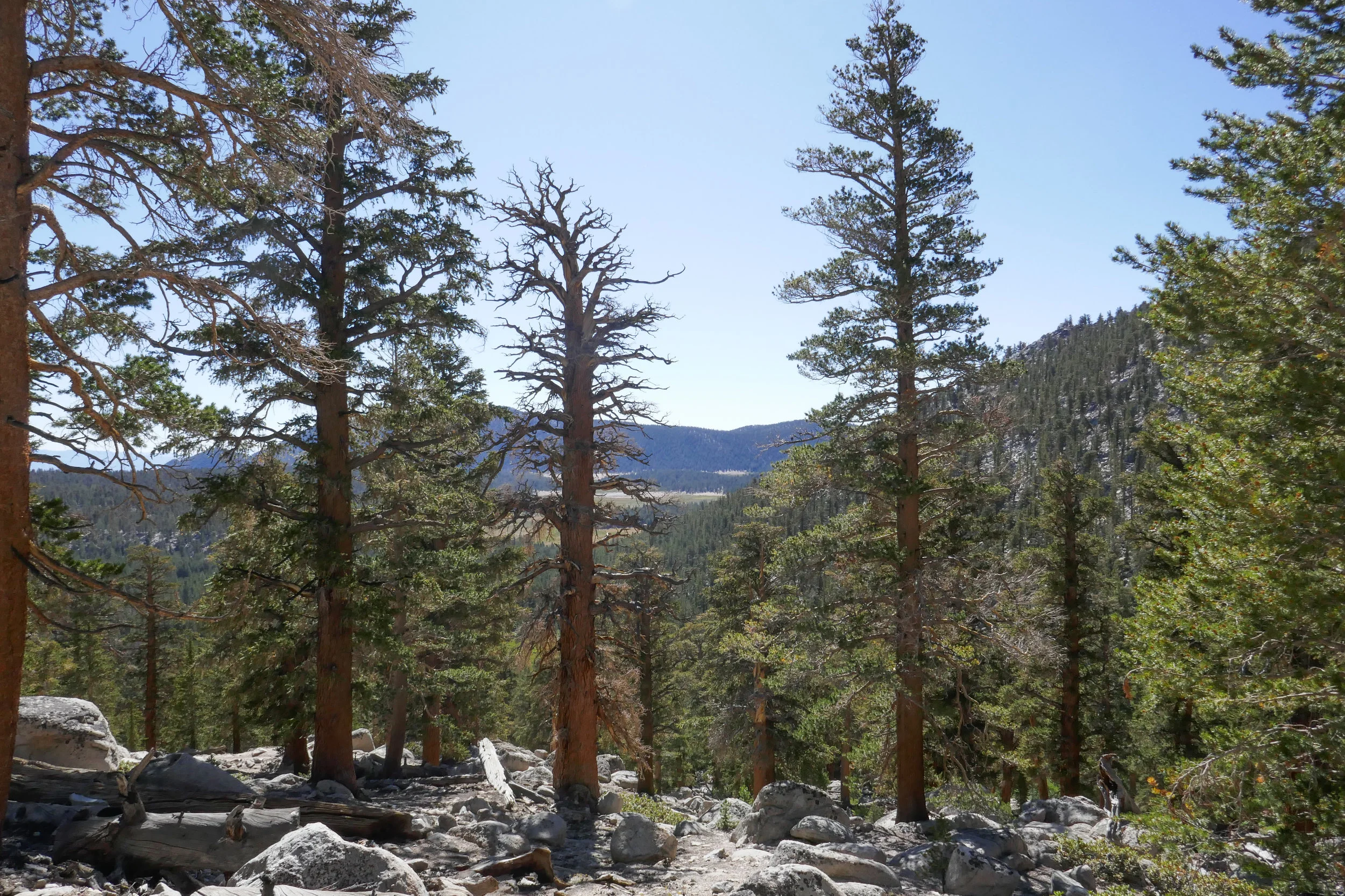
We didn’t really have a plan for our second day in the Eastern Sierra, but I did some quick research after we got back from Big Pine Lakes and decided upon the Cottonwood Pass Trail out of Horseshoe Meadow. Horseshoe Meadow is only about a 30 minute drive from Lone Pine where we were staying. Our plan was to hike up to the pass and then over to Chicken Spring Lake, but when we got started my husband was a lot more tired than usual. I think he may have been feeling the altitude (over 10,000’) and also a little lack of sleep the night before. The hike started out fairly flat winding in and out of tall pine trees until we got to the rocky switchbacks where we started to climb up and up. We passed through incredible alpine meadows covered with wildflowers and under the shade of towering foxtail and lodgepole pines. We were just short of the pass when my husband decided it was time to turn around. It’s really odd for him to be affected by altitude because he’s usually fine, but it just goes to show you altitude does not discriminate. It can happen to anyone on any given day without warning and when that happens, the best thing to do is descend. I would have loved to continue on, but we are a team and so I had no problems turning back and doing the hike again on another day when we could both enjoy it.
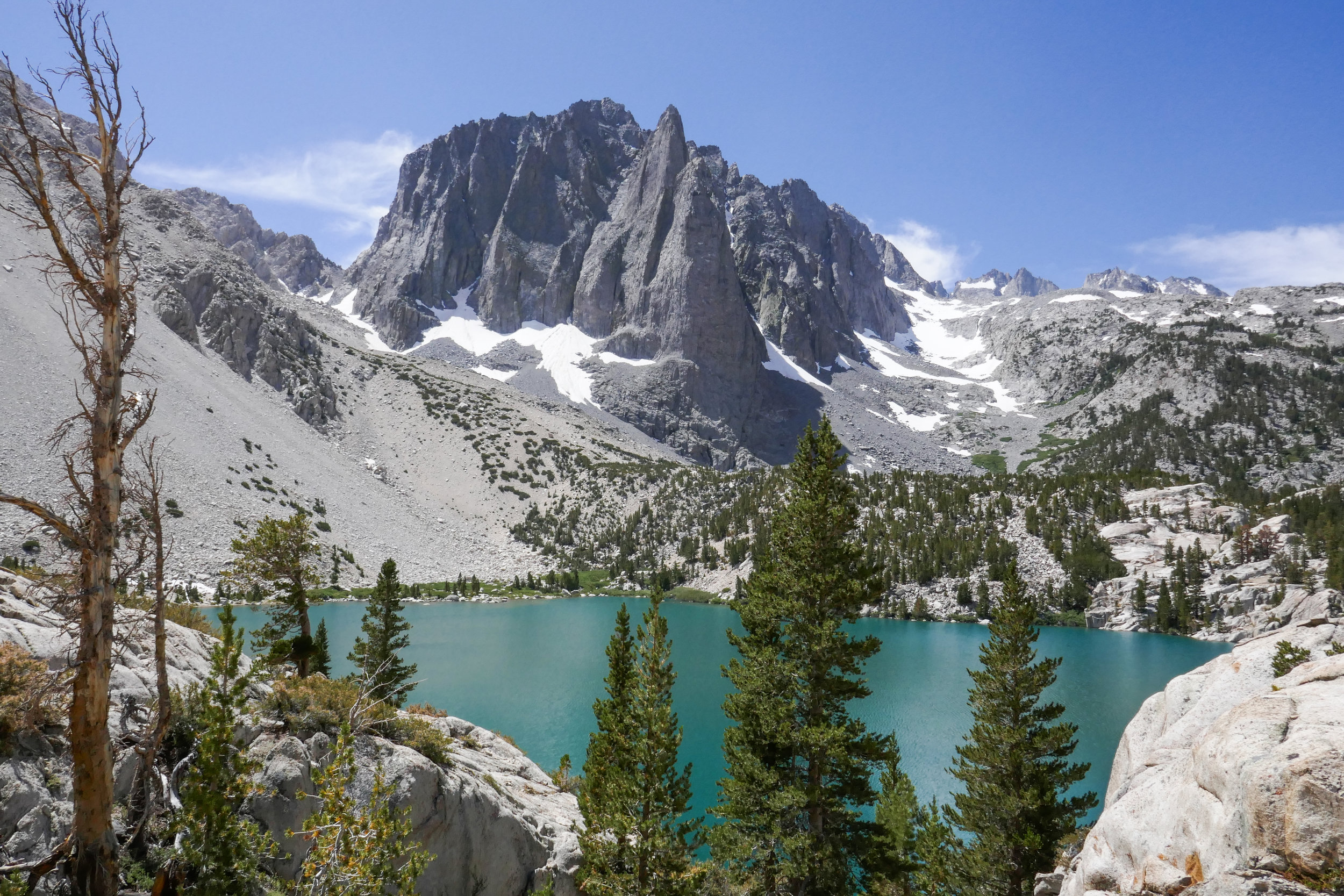
Our hike to Big Pine Lakes in the Eastern Sierra was one of the most beautiful hikes I’ve ever been on. There are seven lakes total and on this day, we hiked to the first three via the North Fork Trail. Since we weren’t backpacking, I had much less weight to carry then when we were in the Eastern Sierra last month backpacking the Mt. Whitney Trail. Most of the Big Pine Lakes hike follows along Big Pine Creek. We were next to the beautiful rushing waters most of the day. Early in the morning when we first got on the trail, we saw two doe and a fawn crossing the creek. There were plenty of wildflowers and butterflies to enjoy throughout the day as well. I took my time on this hike and spent a lot of time taking photos of it all. When we reached lake one we saw Temple Crag (popular with alpine rock climbers) towering over the incredible turquoise waters. The turquoise color comes from the glacial powder of Palisade Glacier. I also saw some trout swimming in the lake. This was a wonderful hike. We had to do some work climbing up in elevation to get to the lakes, but it was well worth the effort because the scenery was spectacular.
The mountains are filled with snow! I wanted to take advantage of it while I could sans the crowds of people I knew would be heading up over the weekend. I took the day off on Friday and my husband and I drove to Palm Springs where we took the Aerial Tramway to Long Valley Station to go snowshoeing. We loved it so much the first time we went a few weeks ago, that we purchased our own snowshoes. There was over three feet of snow on top of the mountain and the conditions for snowshoes were excellent. We spoke with the rangers as we filled out our permit before taking off into the wilderness, and they advised to not go any further than Round Valley due to the potential of avalanche. I’d originally planned to go to Wellmans Divide, but since the rangers know these mountains a lot better then we do, we of course, took their advice. The weather was fantastic! It was a bluebird day with not a cloud in the sky. The fresh mountain air felt great and the snow was fresh powder most of the way. We took our time and savored the journey soaking in the beautiful winter scenery. These are the moments I live for! It seemed we reached Round Valley much faster this time. We ventured into the meadow floating atop three feet of powdery snow and breaking trail. It was my favorite part of the day. Just glorious! All too soon it was time to start heading back. We were about a half a mile from Long Valley when my husband’s snowshoe broke. Somehow the rivets popped out and he was left with just the crampon strapped to his left foot. Luckily, we were not too far away from the trailhead, and he was able to hike back without a problem. Lesson learned -- Always carry a field repair kit. Although we both had microspikes with us, they wouldn’t have been very useful with the depth of the snow. Aside from that minor mishap, it was peaceful day to be out on the trails. I left the big mountain with a feeling of gratitude; so happy to have been able to enjoy another perfect day in this beautiful wilderness!
We had quite a bit of rain over the past few days and I really wanted to try snowshoeing. We had already made plans months ago to spend the weekend in Twentynine Palms, but instead of hiking in the desert like we normally would have, we decided to take the Palm Springs Aerial Tramway up to Mt. San Jacinto. We rented snowshoes from REI in Burbank and were lucky to get the last two pairs available for the upcoming weekend. Seems everyone had the same idea: Take advantage of the snow while you can. I got up at 4 am and we were on our way by 5 am. When we arrived in Palm Springs at 7 am, the parking lot was already getting filled up; families with sleds, coolers, snowshoes, etc., all gearing up for a winter play day. We got our tickets for the 8 am tram and were on our way up the mountain in no time. The tram is a unique activity to do in and of itself. I never get tired of being hoisted up a steep cliff inside a floating bubble travelling up a cable. The transition from desert floor to sub-alpine is amazing and in just 10 minutes we went from the desert floor at 2,643’ at Valley Station to 8,516’ at the top of Mountain Station. The air at the top of the tram was in the 30s. The snow was hard packed and crunchy with some ice. We headed over to the Desert View Loop to try out snowshoeing for the first time. It was actually quite easy. To me it felt a bit like an elliptical machine. The Desert View loop is a short trail with a gentle incline and five notches overlooking wonderful views. It was the perfect place to start. After we had gotten the hang of things, we headed over to Long Valley Station where we filled out a permit and continued on into the San Jacinto Wilderness with our destination being Round Valley. By this time, more people had arrived, some wearing microspikes and there were many groups of snowshoers and winter backpackers. I really enjoyed being able to “float” on top of the snow in the snowshoes. I also liked having a sturdy grip with the snowshoes’ crampon that dug its teeth into the hard packed snow for traction. I felt very secure both ascending and descending. There were a number of people on the trail today, but we were still able to enjoy some alone time. After arriving at Round Valley, we contemplated going up one more mile up to Wellman’s Divide. But instead, we changed our minds and decided to start heading back, knowing we had a cozy room waiting for us in Twentynine Palms. The weather was warming up now, and the snow was starting to get slushy. I think it was a little after 2 pm when we arrived back at Mountain Station. We had no problems getting on the next tram down and were headed out to spend the rest of the weekend relaxing and enjoying the desert. It was a wonderful day. I think I am hooked on snowshoeing and I cannot wait for the opportunity to do it again!
My favorite part of the hike to Josephine Peak are the spectacular views. It’s a steady 4 mile climb to the peak, and today we had a nice, clear day since it had just rained. As we travelled up the fire road from Clear Creek Station just off Angeles Crest Highway, we could smell the eucalyptus trees and the yerba santa. It was even more fragrant today since it had just rained. I’m not quite sure how the eucalyptus trees got here since they’re not native, but they sure do smell nice. As we continued hiking up the trail, I started to get some great photo ops. Strawberry Peak looked quite impressive and we could see a dusting of snow covering the mountaineer’s route. We also had a nice, clear view of DTLA. The views went out all the way to the ocean. To the north, the high country was covered in fresh snow; Waterman, Baden-Powell, Twin Peaks, etc. As we neared the summit of Josephine, we crossed over a bit of snow ourselves. When we arrived at the peak, the views were even more incredible. The last time we were here we were shrouded in clouds so we didn’t get the 360 degree views that we had today. I took advantage and snapped away with my camera. It was absolutely lovely. After spending some time at the summit and greeting a few fellow hikers who’d come to enjoy the day as well, we decided it was time to begin our descent. The clouds started to roll in as we hiked back down the mountain, but we didn’t see any rain. It was an absolutely perfect day.