pine

Josephine Peak, 8 Miles RT, 1,898' +/-, 6,161' Max Elevation, December 24, 2019

Josephine Peak, 8 Miles RT, 1,898' +/-, 6,161' Max Elevation, December 24, 2019

Headed up Josephine Peak today. With storms predicted, I wanted to get in a quick hike before we’d be stuck at sea level for a couple of days. If we get the amount of snow they’re calling for, CalTrans will have their work cut out for them. This next storm is supposed to be bigger than the one we had on Thanksgiving. If that’s the case, the next time we’re up here we’ll be donning the snow gear (and believe me, I can’t wait!). It was a perfect day for this hike. The clouds were rolling past Strawberry Peak making for great photography. The sun was in and out for most of the afternoon. As we wrapped around to the north, it got much cooler and the wind picked up slightly. There were plenty of ravens to watch as they put on their aerial displays, diving and twisting in the sky. They are fascinating birds to watch, and I’ve become enamored with them through the years. We didn’t see one other person on this hike today. I guess everyone is out Christmas shopping. As we headed back, the sun began to lower on the horizon and the clouds started to roll in and wrap around the mountain. Glad we got one in before the weather hits tomorrow!

Read More

Snowshoeing Angeles National Forest, November 30, 2019

Snowshoeing Angeles National Forest, November 30, 2019

It had been raining the past few days, but we got out for a bit on Thanksgiving to do rain hike in Griffith Park. But what I’d really been waiting for was to get up into the forest. The snow levels came down to about 3,000’! We headed up Angeles Crest around 8:30 am and started seeing snow just past Clear Creek Station. We went as far the 6,000’ Day Use Area (just before Winston Peak and Cloudburst Summit) which is where they had the snow gates closed. The road was clear until that point with just little patches of snow/ice here and there, and although we carried chains we didn’t need to use them. We parked the car, geared up in our snowshoes and got to climbing up the hill. There was no trail so we broke our own. We snowshoed up to a high point near John Henge rocks. Our elevation top out was 6,600’. It was a steep, but short climb and enough to give us a good work out. The snow was super deep. We were both in awe of seeing the forest covered in snow at such low elevations. We took in all in and thoroughly enjoyed this gift of an amazingly beautiful early snowfall. I hope this is a precursor of what’s to come this winter!

Read More

Big Pine Lakes, North Fork Trail, Eastern Sierra, 13.6 Miles RT, 2,385' +/-, 10,427' Max Elevation, August 19, 2019

Big Pine Lakes, North Fork Trail, Eastern Sierra, 13.6 Miles RT, 2,385' +/-, 10,427' Max Elevation, August 19, 2019

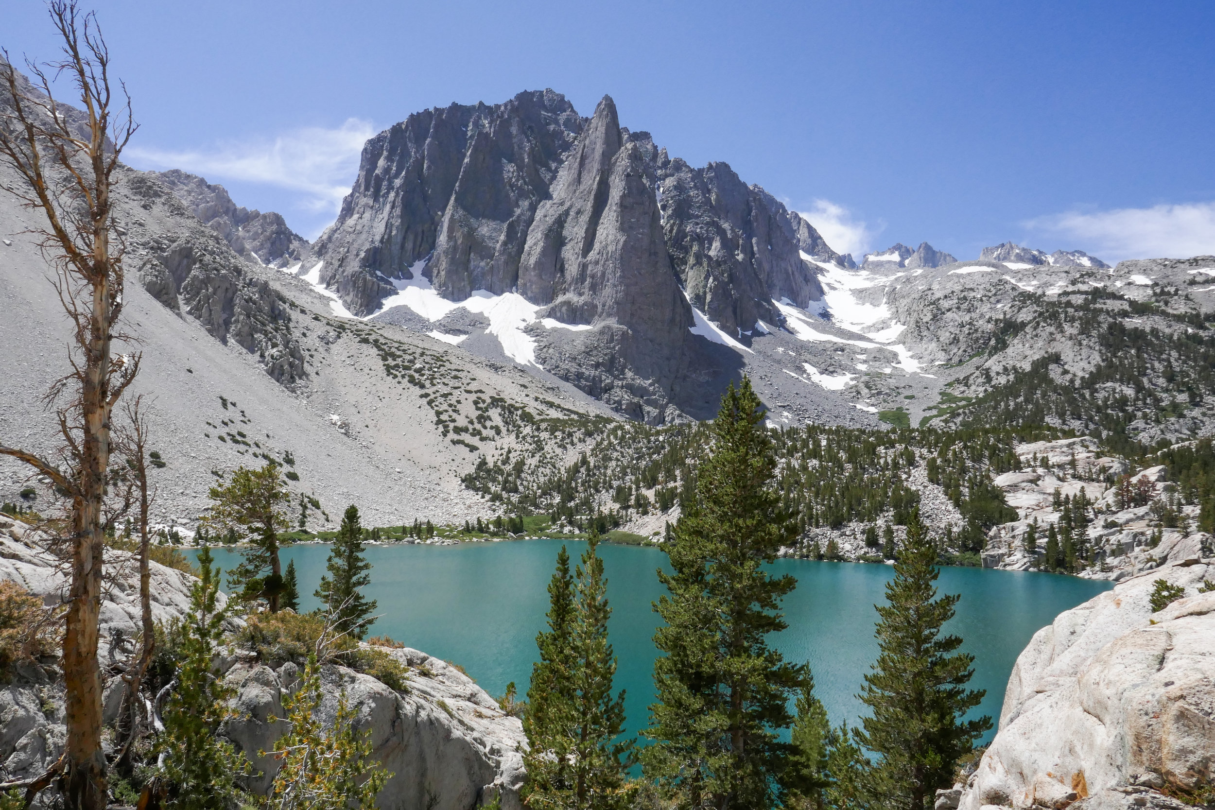
Our hike to Big Pine Lakes in the Eastern Sierra was one of the most beautiful hikes I’ve ever been on. There are seven lakes total and on this day, we hiked to the first three via the North Fork Trail. Since we weren’t backpacking, I had much less weight to carry then when we were in the Eastern Sierra last month backpacking the Mt. Whitney Trail. Most of the Big Pine Lakes hike follows along Big Pine Creek. We were next to the beautiful rushing waters most of the day. Early in the morning when we first got on the trail, we saw two doe and a fawn crossing the creek. There were plenty of wildflowers and butterflies to enjoy throughout the day as well. I took my time on this hike and spent a lot of time taking photos of it all. When we reached lake one we saw Temple Crag (popular with alpine rock climbers) towering over the incredible turquoise waters. The turquoise color comes from the glacial powder of Palisade Glacier. I also saw some trout swimming in the lake. This was a wonderful hike. We had to do some work climbing up in elevation to get to the lakes, but it was well worth the effort because the scenery was spectacular.

Read More

Waterman Mountain, June 23, 2019, 7 Miles RT, 1,371' +/-, 8,038' Max Elevation

Waterman Mountain, June 23, 2019, 7 Miles RT, 1,371' +/-, 8,038' Max Elevation

Every Sunday I wake up at the crack of dawn to hike. This past Sunday when my alarm went off at 5 am, my husband persuaded me to stay in bed. It was nice sleeping in for a change. Once we got up, we went out for breakfast then came home and relaxed until the afternoon. Around 2ish we headed up the ACH and into the Angeles National Forest to hike Waterman Mountain. We had our backpacking gear, and this time I was trying out a new Gregory backpack. My Osprey Kyte was bothering my shoulders, so I thought I should check into another pack. The Gregory seems to be a much better fit on my back. I was carrying around 27 lbs. We did approximately 7 miles taking the Waterman Trail up to the summit at 8,038’ feet and then heading back down on the fire road past the ski lifts to make a loop. We passed by the seasonal pond just below the summit. I’d never seen water in it before, but we’ve had so much snow this year that it looks like the pond may be around for a little while longer. Just as we were approaching the pond we saw a Search and Rescue chopper circling low. This was followed by a vehicle coming up the mountain with a team of rescuers. They showed us a photo and description of a hiker who’d gone missing on Saturday. They asked if we’d seen him, but unfortunately, we had not. We then continued our descent. The forest was quiet and the light was much different then I’m used to seeing it in the early morning. It felt very peaceful. The weekend crowd had cleared out and when we got back to the parking turnout, our car was the only one there. It was so nice I really didn’t want to leave! We got to see the sunset as we drove back on the ACH. It was a really nice afternoon. I think we need to do more late afternoon hikes in the future. It’s a nice change from waking up so early.

Read More

Jackson Lake, Boy Scout Trail, 7 Miles RT, 1,378' +/-, Max Elevation 7,462', Camping Table Mountain, June 1 and 2, 2019

Jackson Lake, Boy Scout Trail, 7 Miles RT, 1,378' +/-, Max Elevation 7,462', Camping Table Mountain, June 1 and 2, 2019

This weekend was our first camping trip of the season! It was time to pull all our gear out and get familiar with it again since we’ll be backpacking the Mt. Whitney trail this year. I love camping. It’s so nice after a day of hiking to be able to build a fire and sleep out under the stars. We headed out of the gloomy cloud covered city up to sunny Wrightwood. There were, however, some scattered storm clouds hanging around, but the rains held off and the clouds passed us by. Our hike today started at Jackson Lake. There were people here fishing and families picnicking. We got on the Jackson Lake trail to the Boy Scout Trail. There’s plenty of shade on this trail as you pass through a forest of beautiful black oaks and towering pine trees. I’d like to come back here in the fall when the leaves are changing. It’s a lovely trail and we didn’t see another person. The Boy Scout Trail eventually ends at a junction for two service roads. You can head southwest on the Pinyon Ridge Truck trail, or southeast on service road 3N26. This road winds around the mountain as it climbs upward with nice views of Mt. Baden-Powell which is still covered in snow at the top. The road eventually takes you to a junction for the PCT, so we headed north here to loop back to the Jackson Lake Trail. We passed about 6 thru hikers on this section heading towards Baden-Powell. Hope they all made it up safely with the snow. It was about 2:30 pm when we got back to the trailhead and headed to camp at Table Mountain. After we set up camp, we went into town and brought back some Grizzly Burgers from the Grizzly Cafe. That’s the nice thing about camping at Table Mountain. You’re about a 10 minute drive from food! Why cook when you can get a burger to go, right? As the sunset and the weather cooled down, we built a fire, toasted marshmallows and enjoyed the outdoors. We had a peaceful night and slept comfortably under the stars. The next morning welcomed us with a beautiful sunrise and birdsong. We had breakfast and then headed home. The weekend was way too short, but I’m so grateful for the times we have like this when we get to be away from the city, traffic, electronics, etc. and enjoy the beauty of the forest.

Read More

Snowshoeing on Waterman Mountain, 3.8 Miles RT, 948' +/-, 7,713' Max Elevation, February 24, 2019

Snowshoeing on Waterman Mountain, 3.8 Miles RT, 948' +/-, 7,713' Max Elevation, February 24, 2019

I am really enjoying this snowshoeing thing! It was a beautiful day, so we decided to venture back into Angeles National Forest taking an alternative route around the recent rock slide on the ACH near Red Box and check out the conditions on Waterman Mountain. The ski lifts had recently been opened, so we knew there would be a good amount of snow. We past the lifts as skiers and snowboarders were just heading into the parking area and parked our car at the usual spot for the Mt. Waterman Trailhead. There was only one other car in the turnout when we arrived, and the air was chilly with an occasional gust of wind. We geared up (There’s a lot more to gear to deal with in winter.) and started up the Mt. Waterman Trail. At the junction with the Fire Road, we decided to head in that direction instead of our usual route. The snow conditions were mixed with sections of crusty ice on top of snow in the shade and a powdery mix in the sun. The snow was deep but packed and the fire road was a bit steep. We got a good workout as we enjoyed the views of snow capped Mt. Baden-Powell in the distance. We took our time and had the route mostly to ourselves. About two miles up we reached the junction with the ski runs. We stopped and watched some of the skiers and snowboarders do their thing. We could have continued on, but decided to take our time and head back. I thoroughly enjoyed every single second of another beautiful winter day!

Read More

Snowshoeing on Mt. San Jacinto, 4.6 Miles RT, Max Elevation 9,229', 961' +/-, February 8, 2019

Snowshoeing on Mt. San Jacinto, 4.6 Miles RT, Max Elevation 9,229',  961' +/-, February 8, 2019

The mountains are filled with snow! I wanted to take advantage of it while I could sans the crowds of people I knew would be heading up over the weekend. I took the day off on Friday and my husband and I drove to Palm Springs where we took the Aerial Tramway to Long Valley Station to go snowshoeing. We loved it so much the first time we went a few weeks ago, that we purchased our own snowshoes. There was over three feet of snow on top of the mountain and the conditions for snowshoes were excellent. We spoke with the rangers as we filled out our permit before taking off into the wilderness, and they advised to not go any further than Round Valley due to the potential of avalanche. I’d originally planned to go to Wellmans Divide, but since the rangers know these mountains a lot better then we do, we of course, took their advice. The weather was fantastic! It was a bluebird day with not a cloud in the sky. The fresh mountain air felt great and the snow was fresh powder most of the way. We took our time and savored the journey soaking in the beautiful winter scenery. These are the moments I live for! It seemed we reached Round Valley much faster this time. We ventured into the meadow floating atop three feet of powdery snow and breaking trail. It was my favorite part of the day. Just glorious! All too soon it was time to start heading back. We were about a half a mile from Long Valley when my husband’s snowshoe broke. Somehow the rivets popped out and he was left with just the crampon strapped to his left foot. Luckily, we were not too far away from the trailhead, and he was able to hike back without a problem. Lesson learned -- Always carry a field repair kit. Although we both had microspikes with us, they wouldn’t have been very useful with the depth of the snow. Aside from that minor mishap, it was peaceful day to be out on the trails. I left the big mountain with a feeling of gratitude; so happy to have been able to enjoy another perfect day in this beautiful wilderness!

Read More

Mt. Hillyer, 5.6 miles RT, 1,112' +/-, max elevation 6,207', January 1, 2019

Mt. Hillyer, 5.6 miles RT, 1,112' +/-, max elevation 6,207', January 1, 2019

Our first hike of 2019 was to Mount Hillyer. I love this hike. There’s so much going on. Lots of great rock formations and change of scenery along the way. It was 39 degrees at Chilao where we picked up the Silver Moccasin Trail with wind gusts up to 50 mph expected at the summit. We had a great hike up. The breezy day was refreshing and there’s not much exposure on this trail with all the boulders, so we were protected from the wind for most of the route. There was a downed tree on the switchbacks of the Silver Moccasin trail. I’m not sure if it was caused by the winds, but luckily it was easy to maneuver over. As we continued our journey upward, the winds became stronger. My core was warm with all my layers, but for some dumb reason I didn’t wear a bottom base layer under my hiking pants. I don’t know where my head was this morning. I knew there would be a wind chill, and I’m usually the one who is over prepared with too much gear. When we reached the gusty summit, I could feel the tops of my legs getting numb. We hauled butt pretty quickly down off the exposed mountain top. I haven’t felt that numb feeling set in since Pennsylvania when I would spend the entire day at the barn riding and taking care of my horses in temperatures below zero some days! Once out of the big gusts, my legs warmed up and we continued our descent. About 1:30 pm, we heard a loud roar in the sky. As we looked up we saw two B-2 Spirit Stealth Bombers flying overhead. They were probably headed back to base after the Rose Parade. Last year we got to see one of them from the top of Waterman Mountain. I didn’t think we’d get to see that this year, but we actually got to see two of them! It was a great way to begin the New Year!

Read More

Devil's Chair, 6.7 miles RT, 1, 260' +/-, 5,396' max. elevation, December 27, 2018

Devil's Chair,  6.7 miles RT, 1, 260' +/-, 5,396' max. elevation, December 27, 2018

I love the hike to Devil’s Chair. We did it in October of 2017 and it’s a beautiful part of the San Gabriels hidden away to the far north. The geological formations that have been formed throughout the years by the San Andreas and Punchbowl Faults are an incredible spectacle to witness firsthand. This area is also a transition zone between high desert and subalpine, and it’s interesting to see how the plants change as you travel the undulating trail. This time it seemed the trail was a bit more eroded in sections then the last time we hiked it, but it was still easily passable without being unsafe. As we approached the Devil’s Chair we descended the switchbacks and navigated the over narrow, rocky cliffs. Thankfully, there’s a metal fence put in place here that allows you to go all the way out to the edge. Otherwise you would not be able to hike here. The views from the Chair were spectacular. Once we’d taken it all in, we climbed back up and had a quick snack break before starting our return. The clouds were starting to roll in and it looked pretty chilly up in the higher elevations on Pleasant View Ridge and Mt. Lewis. The temperature dropped to about 43 degrees as we made our way back and the wind kicked up making it a chilly end to a beautiful winter day.

Read More

Warm and Cozy on Table Mountain, October 7 & 8, 2018

Warm and Cozy on Table Mountain, October 7 & 8, 2018

We hiked along the PCT in Wrightwood from Inspiration Point and across Blue Ridge to kill time before checking in at our campsite at Table Mountain. This section of the PCT has great views of Mt. Baden-Powell and Mt. San Antonio (aka Mt. Baldy). It passes by Mountain High Ski Resort and continues on past the Blue Ridge Campground. Some of the oaks were starting to change color, and it finally felt like fall. We did just over two miles on the trail before it was time to head to camp and get set up so we could settle in and enjoy the evening.

The weather in Wrightwood was chilly! I knew we’d be in for a cold night, but I was looking forward to snuggling up inside the tent in our sleeping bags. After we made camp, we headed into town to pick up a pizza and bring it back to camp for dinner. No point in cooking when you have a pizza shop 10 minutes away! Wrightwood is such a cute little town. It’s a nice change compared to the chaos and sprawl of Los Angeles. All the shops were decorated for Halloween and I even spotted a pumpkin growing outside the Wrightwood Market. As we walked around town waiting for the pizza, I felt that warm and cozy feeling I used to get growing up in Pennsylvania when the seasons would change from summer to fall. This is exactly how it should be this time of year.

When we arrived back at camp, we got the fire going right away. The autumn days are getting shorter and it wouldn’t be long before sunset. We spent the rest of the evening enjoying each other’s company and the warmth of the crackling fire. As the daylight faded and darkness set in, the night sky filled with endless stars. We were almost ready to call it a night when we noticed a bright white light appear in the sky. We watched it as it continued to travel in a southwest direction until finally disappearing. Neither of us knew what it was, but guessed it might have been a comet or some sort of rocket. We didn’t find out until we got back to the city and had cell service that it was, in fact, the SpaceX Falcon 9 rocket launch. What a sight to see from on top of a mountain in the middle of a forest!

The next morning we were in no hurry to get up from our warm sleeping bags. We slept in until well after sunrise. When we did finally get up, we built a fire to keep warm in the chilly morning air, then made coffee and breakfast. There was no rush to be anyplace else, so we took our time and later did a walk around the campground and enjoyed the views from high up on the mountain before it was eventually time to check out and head back to civilization.

Read More

Mt Lowe, 3 miles RT, 5,604' Max Elevation, 548' +/-, September 30, 2018

Mt Lowe, 3 miles RT, 5,604' Max Elevation, 548' +/-, September 30, 2018

My husband and I did a sunset hike on Mt. Lowe this past Sunday. We drove up to Eaton Saddle, followed the Mt. Lowe Fire Road through the Mueller Tunnel to Markham Saddle and then picked up the trail to the Mt. Lowe summit. I really like this area a lot. There’s never very many people and you get some great views of the rugged San Gabriels. The hike to the summit is a short one, but it was perfect for a day when we didn’t have time to do a long hike. The views are pretty great too. As the sun began to sink behind the Santa Monica Mountains to the west, we started to make our way back down the mountain. We reached Markham Saddle just 10 minutes before the sunset then stopped to enjoy the show as the light faded from orange, to pink and finally inky black. It was a little spooky coming back through the Mueller Tunnel in the dark, but the city below us lit up in a romantic, sparkling glow of lights. It was a great way to wrap up the weekend!

Read More

Exploring Mt. Akawie (aka Buckhorn Peak) 7,283' Max Elevation, 3.5 miles RT, 768 +/-, August 26, 2018

Exploring Mt. Akawie (aka Buckhorn Peak) 7,283' Max Elevation, 3.5 miles RT, 768 +/-, August 26, 2018

For my upcoming birthday I asked my husband for a Jetboil cooking system. It would be the first item in a long list of backpacking gear that we’re going to need to make the crossover from day hikers to backpackers. Since I’d been looking for an excuse to make the short hike up the little bump called Mt. Akawie (aka Buckhorn Peak if you’re using a Tom Harrison map), we headed up to the mountain to test the new cooking system and spend a quiet morning together.

We hit the trail just after 6 am. After a very short distance we took the path leading up to the peak. There appeared to be a number of fire roads around to explore, but we were ready to get cooking and I couldn’t wait for a hot cup of coffee. The Jetboil system did not disappoint! For breakfast I’d packed a couple of Eggo waffles (my favorite) and brought along a freeze dried breakfast scramble from Mountain House. Overall, it was pretty good. I definitely could live on this stuff for a couple of days in the backcountry. After eating, we got comfortable on one of the large, flat bounders looking towards Waterman Mountain and Twin Peaks and napped for a short while. After a peaceful rest and stomachs full of interesting freeze dried food, we packed up our gear and did some exploring around the mountain both on and off-trail. An unmaintained road/trail took us northeast around the bump and offered views looking towards Pleasant View Ridge. We also saw a lot of deer; mostly doe and one with a young fawn. The road/trail eventually disappeared and we made a scramble up the east side of the mountain before heading back the way we came. It was around 11 am when we got back to the car. We thanked Mount Akawie for the hospitality and headed home to enjoy what was left of our weekend.

Read More

Onion Valley to Kearsarge Pass, 11 miles RT, Max elevation 11,835', 2,972' +/- August 19, 2018

Onion Valley to Kearsarge Pass, 11 miles RT, Max elevation 11,835', 2,972' +/- August 19, 2018

The trek from Onion Valley to the top of Kearsarge Pass was a spectacular day hike! The Kearsarge Pass Trail heads west from the trailhead at Onion Valley entering the John Muir Wilderness at approximately .7 miles. On this 11 mile round trip journey, we passed through foxtail pine forests, crossed over boulder fields, hiked alongside waterfalls and aquamarine colored lakes filled with golden trout. A final rigorous high altitude ascent up a barren, rocky slope lead us to Kearsarge Pass where the trail crests the Sierra at an altitude of 11,835 breathtaking feet! We were rewarded with the most sublime views I have ever seen; the glaciated Sierra peaks, sparkling turquoise pools of water and views into Kings Canyon National Park. Here are some photos with captions below each to describe our incredible journey.

Read More

Ancient Bristlecone Pine Forest, Methuselah Walk, 4.5 miles RT, 10,183' max elevation, 1,000' +/-, July 11, 2018

Ancient Bristlecone Pine Forest, Methuselah Walk, 4.5 miles RT, 10,183' max elevation, 1,000' +/-, July 11, 2018

On Wednesday morning we drove up to the White Mountains/Big Pine area to spend a day exploring the land of the ancients at the Ancient Bristlecone Pine Forest where a 4.5 mile hike journeys through the oldest living trees in the world. This is a high altitude hike starting out at over 10,000’ feet where the gnarled and twisted trees that look like something out of a Tim Burton movie cling to steep, arid, rocky slopes. The trees thrive in this severe environment and usually survive for over 2,000 years. Incredible! The trail makes its way down a canyon and into a grove of the ancient trees. As you hike down the south facing slope, you’ll note a dramatic transition where there is a wider variety of plants including sagebrush and mountain mahogany. Eventually you will enter the Methuselah Grove. This is where Edmund Schulman in 1957 discovered the Methuselah Tree which is over 4,600 years old. How amazing is that?!

Methuselah’s exact location is not disclosed to keep the tree protected from vandalism, but if you ask the rangers they’ll tell you that the best place to hide something is right in plain sight so you will walk right by the Methuselah Tree along the trek, but you may never figure out exactly which one he is. After the hike we stopped into the Schulman Grove Visitor Center to get some souvenirs and check out the interpretive exhibits. Ranger Dave gave us an informative talk about the Ancient Bristlecone Pines and I am pretty sure I learned more about trees in that 30 minute chat then I ever did when I was in school! I highly recommend stopping in if you want to learn more about these magnificent ancient trees.

Read More

Cottonwood Lakes, 14 miles RT, Max elevation 11,384', 1,660 +/-, Inyo National Forest, Eastern Sierra Trip, July 10, 2018

Cottonwood Lakes, 14 miles RT, Max elevation 11,384', 1,660 +/-, Inyo National Forest, Eastern Sierra Trip, July 10, 2018

I woke up at 4:30 am excited to get started on our new adventure. We had a hearty breakfast and soon were on our way up Horseshoe Meadow Road to the Cottonwood Lakes Trailhead at 10,000’. I took my compass bearings, geared up and we were on our way by about 7 am. The trail enters the Golden Trout Wilderness and starts off on a leisurely stroll through the big pine trees. As we went along we started to gently descend. We followed along side a beautiful creek and made a few water crossings. The mosquitos were out in full force, so I was sure to break out the bug spray before becoming their early morning breakfast. We passed by lush green meadows dotted with wildflowers, corn lily and incredible views of large granite cliffs. Soon we entered the John Muir Wilderness. There was another creek crossing and more lovely meadows to enjoy before we came to the switchbacks. As we began to ascend our pace was slower than usual due to the high altitude. I did not mind stopping to take a few breaks so I could enjoy the views from above and take my photos. As we approached the top of the switchbacks, we could see some peaks coming into view. We passed a junction for Muir Lake and started to see the playful marmots poking their heads out waiting to see if we were going to give them hand out. The trail gently meandered through the meadow with a flowing stream and had incredible views of Cirque Peak and Mount Langley. It wasn’t long before the Cottonwood Lakes came into view. They were stunningly beautiful. We took a moment and sat in the shade to take a break, have a snack and enjoy the scenery, peace and quiet. We made our way to lake #3 and followed along its shore to a short climb up some switchbacks. On the other side we reached lakes 4 and 5. We felt a light breeze and could see the summer storm clouds rolling in closer, but I didn’t hear any thunder. We thought it was a good time to start heading back. We had quite a ways to go before reaching the end of our journey. As we made our way down the switchbacks we enjoyed another marvelous view of lake #3 from above. We passed a man with his two sons who were fishing, but he said they hadn’t had any luck. As we made our way back to the trailhead, I could feel some light precipitation. The cool raindrops on my skin felt refreshing after a long day and the smell of summer rain mixed with the pine was intoxicating. We got back to the trailhead around 3:30 pm and clocked about 14 miles. It was my first time hiking for that long at such a high altitude and I was both tired and exhilarated at the same time. It was an incredible experience. The Eastern Sierra has so much to offer. I have fallen in love.

Read More

Mount Pacifico 7,134', 2,398' +/-, 14 miles on the PCT from Mill Creek, June 3, 2018

Mount Pacifico 7,134', 2,398' +/-, 14 miles on the PCT from Mill Creek, June 3, 2018

I’m always looking to escape weekend crowds and find new trails to explore. This Sunday our hike was to the top of Mount Pacifico in the northern part of Angeles National Forest. We planned to start the hike at Mill Creek and follow the PCT which runs through this area. It looked like the trek would be around 12 to 14 miles depending on whether or not we did an out and back on the PCT or did a loop. The day was going to be hot, but I figured since we were heading up to a higher elevation, it might not be so bad on the ascent. If it got too hot, we would descend and save it for another time. The trail was very beautiful. There were many wildflowers and so much ceanothus (California lilac) which made for a very pleasant fragrance along the way. There was lots of wildlife activity too; squirrels, chipmunks, songbirds, bees, insects and butterflies. As we climbed higher, we started to see beautiful, tall pine trees. Much of the area was burned in the 2009 Station Fire, and we could see the effects of that as we hiked this route. But the area looks as though it’s been recovering nicely. Eventually, we reached a junction where we left the PCT and headed southeast to a jeep road that took us up to the summit. There are outstanding views of the surrounding mountain ranges along the way making the road more interesting. After about a mile or so we reached the summit. Mount Pacifico Campground is also here. There are picnic tables, a fire ring and vault toilets. That’s quite a luxury to have up on a summit! There are also a lot of very interesting rock formations to explore. There wasn’t anyone here today, so we took a good long rest and relaxed and enjoyed the peace and quiet. Soon it was time to head back and get ready for the heat as we descended to a lower elevation. We opted to come back the way we came on the PCT for a more scenic and enjoyable route. Both of us had been keeping well hydrated throughout the trip and we had no problems with it being so warm. We were even gifted with an occasional breeze as we hiked back down the mountain. I found this trail to be very nicely graded so although it was long, it was very pleasant. A very enjoyable hike!

Read More

Mount San Jacinto 10,834', 11 miles RT, 2,437' +/-, May 25, 2018

Mount San Jacinto 10,834', 11 miles RT, 2,437' +/-, May 25, 2018

I took the day off on Friday so we could revisit San Jacinto Peak.  We were thinking about hiking up from Marion Mountain, but first I wanted to try it again from Long Valley, so we made a fun day out of it by taking the Palm Springs Aerial Tramway way up to start the hike out at 8,516'.  Just as I remembered, the San Jacinto Wilderness was absolutely breathtaking.  Also, just as I remembered, the altitude kicked my butt!  It was a slow and steady climb for me today, but with the beautiful forest and the amazing scenery I wasn't complaining about taking my time.  As we approached the summit, the trail disappeared into the pile of boulders that I had been so nervous to climb last time we were here.  This time, knowing what to expect, I had no problem.  It was actually a lot of fun climbing up those rocks this time!  We spent some time at the summit, had some lunch and enjoyed the expansive views.  Hardly anyone up here today.  It was so pretty with all the fluffy clouds passing just below the peak.  After we were done soaking in the views, we began our descent and I made sure to take plenty of photos to remember the day.  We hope to be back again sometime before the year is over to try this one from Marion Mountain. 

Read More

Burkhart Trail from Devil's Punchbowl, 12 miles RT, 3,038' +/-, April 1, 2018

Burkhart Trail from Devil's Punchbowl, 12 miles RT, 3,038' +/-, April 1, 2018

The Burkhart Trail from Devil’s Punchbowl has been on my bucket list ever since the first time we hiked to Devil’s Chair and the Punchbowl loop.  I wanted to get this one out of my system before the weather got too hot knowing that much of the trail is exposed.  This hike is kind of like two for the price of one.  It has a lot of diversity along the way taking you from the desert floor to the alpine zone.  The first part of this hike drops you down to Cruthers Creek which is lower then the elevation from which you started at the trailhead.  This section is a beautiful trek unto itself, but you have to remember to save some fuel in the tank since you’ll have to hike back up out of the canyon later on.  Next, you cross over Cruthers Creek and from here on out it’s a long, steep haul toward Burkhart Saddle.  Personally, I didn’t find the climb all that difficult.  BUT… what I didn’t expect were the lengthy sections of trail with loose rock on sometimes very narrow and mostly exposed slopes.  This trail has all kinds of terrain to hold your attention from beginning to end.  We encountered soft sand, loose scree, talus, and pine needle covered track.  I really enjoyed hiking through the different plant communities in this unique transition zone.  As we continued onward and upward, there was a nice, cool breeze coming up out of the canyon to keep us comfortable.  The higher we went, the more the temperature cooled and trail seemed to become more and more rocky with very few breaks in between.  At about 6 miles in, just one mile short of the saddle, we hit our turn around time.  We looked over at the saddle which seemed so close, yet so far!  Then we looked at the trail ahead of us...  More rock!  Ugh.  We contemplated making the final push anyway, but we both agreed it would be even more slow going on the way down and decided we should start heading back.  We also still had to make the climb up out of the canyon.  Carefully we negotiated our way down the slope.  My trekking poles came in handy here.  When we arrived back at the creek, I got distracted by all the little Lotus Hairstreak butterflies.  I spent some time chasing them around trying to get a good photo.  (Or maybe I was just procrastinating the climb back up.)  As I tried to focus my camera on the tiny green butterfly who was posing so patiently on a leaf, a hummingbird mistook my bright fuchsia tee shirt for a flower.  He swooped so close I could feel the flutter of his tiny wings.  He swiftly flew away when I looked over my shoulder at him and he realized he was mistaken.  As we began the final climb up out of the canyon a hazy cloud cover kept the sun at bay, and I enjoyed snapping photos of the ever changing scenery on the trek back to the trailhead.  Overall, I really enjoyed this hike and would do it again.  Perhaps next time we’ll start a little earlier now that we know what to expect with the rugged terrain.

Read More

Snow Hiking on Waterman Mountain, 2018-03-04

Snow Hiking on Waterman Mountain, 2018-03-04

What an incredible day in Angeles National Forest!  I was hoping to get to see more snow before the winter was over, and today I got my wish!  I woke up at 5 am and we headed up Angeles Crest Highway just after the sunrise.  I didn’t want to leave too early not knowing what the driving conditions would be like.  As we got higher up in elevation, we started to see the snow.  The roads still had a very light covering, but the driving was fine and there was no ice.  It was beautiful just driving along the highway.  Our destination was Waterman Mountain.  This trail is one of my favorites in the summer and seeing it for the first time in winter was a treat!  The pine trees were heavy with snow and icicles.  The forest was incredibly serene and peaceful.  The only sounds we heard were the birds singing and the ice melting off the majestic pine trees.  The air was fresh and the sky was crystal clear.  It was a bluebird day for sure.  Today was also the first time I’ve ever had the opportunity to photograph snow.  When I lived in Pennsylvania, I hadn’t gotten into photography yet.  Also, I was just so used to having snow in winter, that I really didn’t think much of it.  Well that sure changes when you don’t get to see it anymore.  I could not have asked for a more perfect day.
 

Read More

Mount Hillyer, 6,215', 6 miles RT (1,129 +/-), January 21, 2018

Mount Hillyer, 6,215', 6 miles RT (1,129 +/-), January 21, 2018

The trek to Mount Hillyer in the central San Gabriels is a meandering hike through impressive boulder formations and flat sections of beautiful pine meadows.  This land was once used by horse thieves, the most notorious was Tiburcio Vasquez.  This area was the perfect hideout for bandits to escape from the law and pasture stolen horses.  The trail starts off at Chilao just past the visitors’ center on the Silver Moccasin Trail.  The first section is a series of switchbacks through rocky terrain.  After about a mile, it smooths out and you’ll reach Horse Flats Campground.  It’s a beautiful camp equipt with corrals and hitching posts for equestions who ride in and want to stay the night with their horses.  From here you pick up the Mount HIllyer trial and this is where you’ll start a steady ascent through the ginormous boulders.  We took our time on this hike and had a lot of fun climbing around the various rock formations.  As for the summit, there are actually two.  The unofficial summit stands at 6,215’ and the second official summit is 6,162’.  You’ll come upon the unofficial first.  Once you’re done enjoying the views from there, you can hike just a little further up the trail and find a short use trail off to your right that goes to the official summit.  We stopped there and had some breakfast.  There was absolutely no one on the trail today.  After we were done enjoying the peace and quiet of the forest, we headed back down towards Santa Clara Divide Road.  We followed the road back to Horse Flats and then back to the Silver Moccasin Trail and Chilao.  Loved this hike today.  Short on the mileage, but very big on the scenery!

Read More