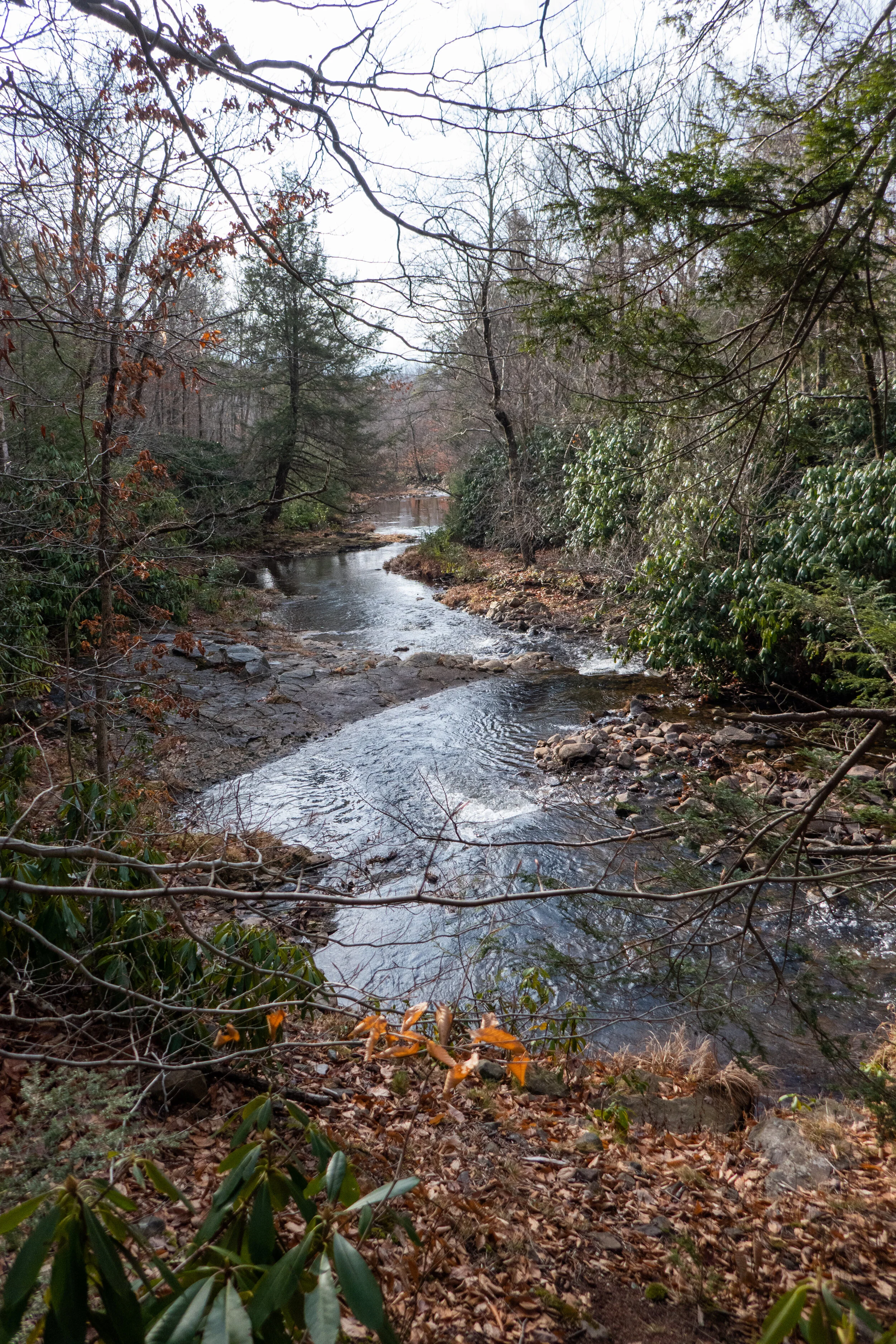
Today we spent the day exploring the Bald Mountain tract of Lehigh Gorge State Park near Rockport. Bald Mountain looked interesting to me because the access point isn’t located near any of the popular areas of the park. We found the turn off to the trailhead which wasn’t signed and if you blinked, you’d miss it. We parked the car and right away I heard the clack, clack, clack of the ravens above. I knew it was going to be a good hike. I have such a soft spot for these birds. They remind me of my hikes in California because they were always around when I was hiking in the higher elevations. We began the trek near Indian Run and crossed over the bridge which lead us into a beautiful forest of pitch pine and hemlock. The wide trail headed east with a steady incline up to the top of Penn Haven Mountain with the Lehigh River flanking us to the north, east and south. There was a junction here and signage for the Bald Mountain Loop. We followed the trail northeast in a clockwise direction being careful not to slip on the ice that was hidden under a thin layer of snow. It was about 30 degrees with about a 12 mph wind which made it seem much colder then it was. The loop dropped us down in elevation and eventually gave us a nice climb back up. It was a beautiful section of trail, although there was a lot of water we had to navigate around in addition to the ice. Once back at the top we found signage for the Vista Trail. The trail narrowed and lead us out to the rocky south facing cliff side of Bald Mountain. Here we had nice view down into the deep gorge and across to Scrub Mountain. We sat for a bit in the sun to warm up, but even in the sun it was still quite chilly. As we made our way back, the winds continued and we kept moving. The afternoon sunlight coming through the trees was absolutely gorgeous! I really enjoyed this hike. It was such a beautiful day despite the wind and I will definitely be back to explore more of this beautiful area.
Beautiful day in the Delaware State Forest. We started the day by stopping off in Promised Land to check out the Little Falls trail along East Branch Wallenpaupack Creek. It was 18 degrees in the morning, and as I walked I could feel the ice underneath the frozen leaves cracking beneath my boots. The creek was moving fast and there were icicles clinging to the trees. I took a few photos and headed out to the trailhead for Egypt Meadow Lake off the 390. We started the trail heading east in a clockwise direction, but soon came upon an area where the water from the lake had breeched the trail making it impassable. There’s been so much rain over the past few days that it’s caused the snow to wash away and the rivers and creeks to swell. We backtracked and took the trail in the opposite direction. It was a beautiful walk through the forest with rock outcroppings lending spectacular views of frozen Egypt Meadow Lake. The trail undulated gently up and down over the typical rocky Pennsylvania terrain until we reached the junction for Bruce Lake. From here we continued eastward on a wide road with a lot of icy sections that were easy enough to navigate around. We arrived at Bruce Lake which was also frozen over. I tested the water with my boot and it felt solid. I could see footprints of a person and their dog who had ventured out onto the icy lake. We took a short break here to enjoy the scenery, but with the below freezing temperatures we didn’t stay too long before we needed to get moving again. On the way back we took the Panther Swamp trail to reconnect with the Egypt Meadow Trail and returned to the trailhead. The parking lot at the trailhead was still a sheet of ice. It didn’t go above freezing the whole day, but there were no winds which made it a perfect day for winter hiking.
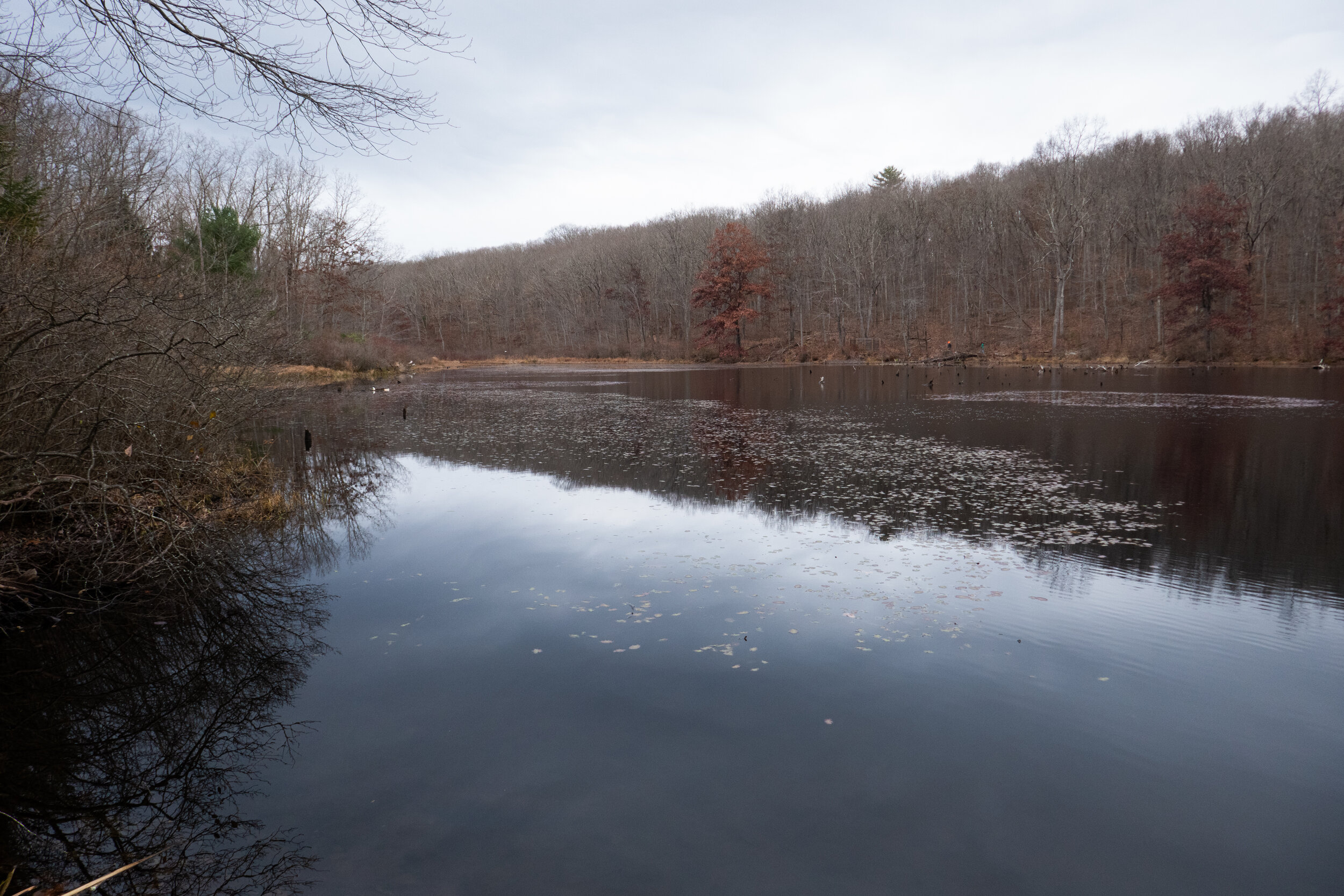
Another cold day here in the Keystone state. Today I was up and out earlier then yesterday and heading up north to the Pocono Mountains to Nescopeck State Park. The temperature this morning was in the 20s and expected to climb to about 30. The DCNR page was reporting a higher snow level at Nescopeck, and I was looking forward to snowshoeing in a bit more snow. I’m still uncertain how well they plow the roads so venturing out is a bit of an unknown adventure. We turned the car onto Honey Hole Road and it was clear. None of the turnouts were plowed, but the main lot for the lake paring was completely open. We arrived to find only one other car. I was completely baffled where everyone was? Why aren’t people out enjoying this winter wonderland? I can only conclude that where I have lived in California, snow is a novelty. Every time it would snow, Angelenos (myself included) couldn’t wait to drive up into the forests and mountain towns for outdoor recreation. Maybe winter in Pennsylvania is just an inconvenience to those who’ve lived here all their lives winter after winter. I honestly can’t say but regardless of the reason, I was not complaining about having the place pretty much to ourselves. We donned our snowshoes and headed over to Lake Frances which was just beginning to ice over. Winter is such a different world. We snowshoed around the Lakeside Trail and made our way onto the Nescopeck Trail being careful not to step onto the tracks that had been made by the cross-country skiers (outdoor winter etiquette). The snow conditions here were perfect! We had soft powder and each step was a joy to take. We trekked along until we reached the Creekside Loop Trail which crossed over Nescopeck Creek by way of a rickety, wooden bridge. The sound of the running creek and the chirp of a chickadee were all I heard in the quiet of the forest. As we continued south, I remembered we were going to end up at a trail washout that we’d encountered over the summer and would have to loop back on the Fern Trail. I made my way through the snow and along the edge of the creek enjoying every moment. The giant hemlocks heavy with snow leaned in over the partially frozen water. On our way back, we passed a couple of cross-country skiers. Again, another great place to cross-country ski with the mostly level terrain. We took our time going back and soaked in the beauty of winter. We arrived back at the frozen lake with my Garmin clocking us at about 4.8 miles. I checked the temperature just before heading home and it had reached 30 degrees by about 1:30. It was a lovely day on the eve of the winter solstice to enjoy the outdoors!
It was Saturday morning, two days after the snow storm and it was time to test out snowshoeing in Pennsylvania. Not really knowing how well the roads would be plowed further north, I decided it was best to stay somewhat local. I checked the DCNR State Parks Winter Reports page for the conditions and snow levels at Jacobsburg State Park. The reports showed 11 inches of snow which was enough for snowshoeing. It was 7 degrees when I woke up. I wasn’t quite sure how that was going to feel. I’m used to Southern California weather. In SoCal this time of year the temperature might (and that is a big MIGHT) drop into the 30s, and then I’d drive to higher elevations for snow and colder weather. In Pennsylvania winter is right outside my door. I suited up in my winter hiking gear and headed out. When I arrived at Jacobsburg, I was surprised to see there were very few cars in the well plowed lot. I thought for sure since this park is so close to town that there would be families with children sledding and many more people enjoying the winter wonderland. There was hardly anyone, and I was not going to complain. I suited up and headed out along the blue trail to get the blood flowing. The snow was more of a hard pack because during the storm, it was mixed with sleet. I followed the blue trail which loops around the edge of the park. I passed a group of cross-country skiers which I’m learning is a popular sport here. I can see why with the wide trails and easy going terrain. I reached the junction for the trail that would loop me around to the bridge that crosses over Bushkill Creek and headed into Henry’s Woods. The creek was starting to freeze over with icicles clinging to the rock walls along the creek. The giant hemlocks towered above. It was just beautiful. I finished the loop with about 3 miles RT. It was a nice warm up hike and introduction of what to expect after experiencing my first Pennsylvania snow storm in 20 years.
Beautiful creekside hiking at Bear Creek Preserve this weekend! This has been my favorite hike in NEPA thus far. We started from the trailhead at Rabbit Run Lane on the red trail and connected to the gray tail heading south along Shades Creek. This section of trail was just beautiful with many cascades flowing into deep, clear pools, waterfalls and undulating trail through rhododendron jungles, in and out of hemlock forest and mossy wetland. Before reconnecting to the red trail and heading back north, we crossed over Shades Creek on a really cool suspension bridge. The terrain for most of this hike was rocky and slippery with wet leaves, but I'm getting used to my feet taking a beating on these east coast trails and learning to slow down a bit and take my time. East coast hiking is very different from out west. There may not be much elevation to gain, but I’m starting to find some locations that feel a little more remote where we can track some decent mileage. We followed the red trail back to the trailhead and closed the loop at about 7 miles RT. Absolutely beautiful place to explore.
Foggy weather made for an eerie day of photos at St. Michael’s Cemetery in Bethlehem, PA. The land for this cemetery that sits on a northern, eroding slope was donated in 1867 by Asa Packer to create the first burial place in Bethlehem for immigrants who worked and died here. At that time, families staked out their own burial plots and maintained them without help of the church. There are first-hand stories of people who witnessed middle-of-the-night burials without permission from the church or formal services for their beloved dead. There is only one noted existing map of the burial locations created by William Sinnott in 1930. Sinnott tried to establish some sort of order to St. Michael’s by mapping out the graves using data he found on the ground. The records are incomplete and many of the grave sites, especially those located higher up the hillside and deeper into the woods are missing. Over the years, severe erosion, wall failure and exposure to poor weather conditions caused many of the headstones to fall over, slide down the slope or become buried. The evidence of this was very apparent as I traversed higher up the hillside and farther back into the woods through leaf debris, decaying vegetation and deep ruts in the uneven ground that exposed broken or mostly buried gravestones. Many gravestones were lost until recent times when volunteers unearthed over 500 stones that had been hidden beneath the sod for decades. Today St. Michael’s is cared for by a group of folks who run a Facebook page called Friends of Saint Michaels. It is their hope to raise awareness of the historic and cultural value of the cemetery and they’re always looking for volunteers to help them with their efforts. It is a huge project to take on and vandalism, eroding soil and harsh weather do not make this an easy task.
The D&L Trail is a 165-mile multi-use trail running from Wilkes-Barre to Bristol. The northern terminus is located in Mountain Top, Luzerne County with its highest point being 1,785’. The trail follows the same route that the anthracite coal once took from mine to market and winds along the Lehigh and Delaware Rivers. As you walk the towpath, there are interpretive signs that mark points of interest on the trail. Since the trail runs along the river, there’s lots of wildlife to be seen here. I walk this path some days in the early mornings and there’s plenty of species of birds including Bald Eagles which are making a comeback in the area. Bald Eagles are listed as protected and no longer considered endangered or threatened. Last week I happened to see one flying upstream along the canal. I didn’t see any Bald Eagles today, but I did catch a glimpse of a Red Fox making its way across the trail. I walked about 2 miles to Hope Road where there’s a washout apparently left over from Tropical Storm Isaias. It’s not impassable, but I made this my turnaround point since I was short on time this morning. The D&L National Heritage Corridor is full of history and is a great place to come for fresh air and exercise when you just need to get out for an easy walk on the trail.
Wednesday was the first snowfall of 2020 in Bethlehem, Pennsylvania, and I was not going to let the beauty of it pass by without getting some local photos. The Monocacy Nature Trail is a place I sometimes like to come to in the mornings to take in the fresh air and enjoy the wildlife before getting my day started. I was so excited to see it covered in a fresh of dusting snow. While I’m not really sure what to expect here in NEPA, winter in SoCal was my favorite time of year to drive up to the mountains and enjoy the weather. I’m looking forward to seeing what the months ahead will bring and hopefully getting in some snowshoeing.
Today we spent a few hours exploring Bear Creek Preserve in the Lehigh River Watershed. The preserve is part of a network of protected lands and the hiking trails here are pristinely beautiful. There are about nine miles of rolling trails leading to waterfalls, crystal clear cascades, rocky ledges and through hemlock, pine and rhododendron. It was about 30 degrees with a wind chill today, and we had some snow flurries. The ground had just the slightest dusting of snow. Winter is finally setting in. There are three streams running through the preserve: Shades Creek, Bear Creek and Stony Run. We hiked the yellow and green trails which took us to an overlook and then stream side along Shades Creek to the top of a flowing cascade. We didn’t have time to hike much more today, but I am looking forward to coming back here and exploring more of the preserve
Ended the four day weekend with a hike around the Trexler Nature Preserve. It was the last Sunday with hunting allowed in Pennsylvania, so we kept to the safer areas for outdoor recreation. I have to say there were some pretty decent hills to go up (and down). I have yet to see very many switchbacks here in Pennsylvania. When the trail goes up it’s pretty much just a straight shot. So while there really isn’t much in the way of altitude, these hills don’t mess around with their steepness.
I watched the sunrise the morning from the shores of Leaser Lake located near the Village of Jackson in Lynn Township, Pennsylvania. The 117 acre lake is named after Frederick Leaser who was an American patriot. Leaser transported the Liberty Bell from Philadelphia to Allentown in the year 1777 for protection during the Revolutionary War. There’s a four mile loop that goes around the entire lake with great views and variation in scenery from lake views to woods to meadows. I hiked the loop today and the lighting and scenery was beautiful. There’s plenty of wildlife to see here. It’s a great place to come if you’re a bird watcher and there’s an information board near the south parking area listing which birds to look for. I really enjoyed the morning here and will definitely be back again.
Today was Black Friday and as per usual I did not participate in any sort of shopping madness, but instead headed for the outdoors. Yesterday, Thanksgiving Day, began a four day weekend for me, and I was looking forward to taking advantage of the time off. This morning I started my day with a hike around Jacobsburg State Park. There weren’t many cars in the lot when I arrived which surprised me being it was the day after a holiday, but it was still very early. I grabbed the camera and headed into the old growth forest of Henry’s Woods and followed along Bushkill Creek. From here I looped around up through the meadow just outside the perimeter of the no hunting zone. It was the first day of rifle season, and I didn’t want to take any chances venturing off alone into the hunting areas. It was a beautiful, crisp morning and a perfect day to #optoutside. I’ve never really been big on shopping anyway, unless of course it’s REI.
Today I hiked around the Trexler Nature Preserve. Pennsylvania is doing a thing this year where they are allowing hunting on three Sundays, this past Sunday being one of those weekends. It’s very odd to me that the state lets people hunt and hike in the same areas, but many of the state parks here seem to be on state game lands. Regardless, I wanted to play it safe and not have my head mounted on someone’s wall, so I stuck to the nature preserve where most of the trail was on open lands and did not allow hunting. I started on the Border Trail which actually goes around the entire preserve and then crossed over Jorden Creek to make a loop back to the trail head. During the hike I crossed path with a deer and saw plenty of birds in the open fields. It was a short hike, just a little over 5 miles with a lot of ups and downs in the hills. I was happy to get out for a bit and enjoy the outdoors.
It was a beautiful, cloudy day for a hike around Nescopeck State Park. I started the hike at the Creekside trailhead off Honey Hole Road. Less then a mile into the hike I had to detour on the Fern Trail because there was a washout across the creek. From there I took the junction to the Nescopeck trail over to Lake Frances. As I approached the lake I could feel the cool mountain breeze across the lake. It was still early and the place was deserted. My husband and I sat at one of the picnic tables by the lake and had a snack before moving on. We took the Woodland Way trail over to a pond that had an area for turtle viewing. Much too cold for turtles today, but the pond was beautiful in its stillness. As we started the trek back, the dark clouds started to roll in. They were calling for rain around 12 noon and we got back to the trailhead in plenty of time before it started to sprinkle. It was a lovely day in the Pennsylvania woods.
Big Pocono State park sits atop the summit of Camelback Mountain at about 2,100’. You can drive your car up to the top and enjoy a day of picnicking with views below of Eastern Pennsylvania, New Jersey and New York. There are hiking trails that start at the summit and traverse down the mountain and then back up. Today we hiked the North Trail to its lower loop and then circled back up the south face on the South Trail. The trail was surprisingly steep with about a 600’ change in elevation in under a mile. I haven’t needed to use my hiking poles since I left California, but I could have used them today. At the bottom, the trail flattens out and is paved with gravel. It passes through an old railroad grade and through a rock cut in the mountain. I saw a lot of rhododendron along the way so I’m sure this is a beautiful place to be in the spring when the flowers are blooming. The loop is just a short 4.6 miles, but there was enough of a challenge to get the heart pumping.
Today I had a quiet morning walk around Mariton Wildlife Sanctuary. It looks much different now with the trees changing colors and losing their leaves. The meadow that was so vibrant with wildflowers and active with wildlife was still except for a lone late season butterfly. The morning was crisp and it felt good to get out and walk up and down the steep hills to warm up. At the end of the hike I stopped at the bird blind to watch some birds on the feeders. This is always a quiet place to come and it’s nearby so I don’t have to drive too far. I suspect once all the leaves fall there will be some views down to the Delaware River. I’ll have to come back in December (if not before) and see.
I recently discovered the Graver Arboretum, a hidden gem located in Bushkill Township, Pennsylvania while my husband and I were out for a drive. He noticed a sign, and we decided to stop. The arboretum is used as an outdoor classroom by the biology and other science departments of Muhlenberg College. There are a few trails here and it’s a quiet place to walk and relax. This was our second visit to the arboretum. The first time I didn’t have my camera with me. This time I brought it along. It was a cloudy, overcast day. There were a number of Canada Geese on the pond and the leaves were falling as we walked along the quiet path. It’s a nice place to come to visit when I just want to relax in nature without a long day of hiking.
This morning I went to Promised Land State Park. It looks so different then when I was here at the end of September before the leaves started changing. I still can’t get over the amazing colors. I started the morning with a walk around Conservation Island. It was very peaceful early in the morning and I sat down at one of the benches that are conveniently placed along the path to enjoy the views of Promised Land Lake. As I gazed across the water at the lakeside cabins, it gave me the feeling of being in an old town in New England. The walk around the island was short, but packed with spectacular color. When I returned to the trailhead, I got back in the car and made my way to Lower Lake Road. I pulled into the turnout for the Village Trail, but there were two hunters getting out of their truck with their rifles which is not something I’m used to or comfortable with. I decided to go to a different trailhead instead. I continued a little further up the road and parked at the turnout for the Loggers Trail. After consulting the park map I decided to hike over to Little Falls which on the East Branch of Wallenpaupack Creek. I really enjoyed this section of the hike. It was gorgeous hiking along the creek. Eventually I left the beauty of the creek and made my way west on the Spike Trail. I followed the Spike Trail to the Saw Mill Trail which ran alongside a deer enclosure. Deer enclosures are used to prevent deer “browsing” which is basically eating and killing vegetation. The weather was warm today, but there was a light mountain breeze. Even even though there are no dramatic mountain summits with views here like there are in California, I got the sense that we were at a high point on top of the mountain with a little bit of elevation. After looking at the topography, we were at about 1,700 feet. It was a quiet day to hike around the Pocono Mountains. I imagine it will be a busy weekend with everyone coming up to see the fall foliage.
The colors are really starting to show in Pennsylvania. Today I went to Jacobsburg State Park and walked from Henrys Woods over to the the National Historic District Site to check out the Henry Homestead/PA Longrifle Museum. I also took some time today to check out the birding area across Belfast Road near Henrys Forge. I didn’t have my birding camera with me, but I was able to get some decent photos of a tufted titmouse, black capped chickadee and a nuthatch. The day was cloudy and a little on the warm side for October. Now is the best time to enjoy the fall color before the leaves fall. It’s a beautiful time of year here on the east coast.
It was a perfect day to explore more of Hickory Run State Park. This is a beautiful park with so much history. We started the day off by hiking past the Manor House, the former dwelling of Samuel Gould. In the 1800s, the Goulds were the primary landholders of the region and owned many sawmills here. We past the Manor House and headed onto the Fourth Run Trail. This is the longest trail in the park, but today we diverted onto the Stage Trail which was once a stagecoach road that went from Bethlehem to Wilkes-Barre. The Stage trail took us to to the Saylorsville Dam where we followed the winding paved road across the ford and then back to the parking area. It was a lovely walk and I enjoyed meandering along enjoying the fall foliage. Once back at the trailhead I wanted to check out the old Hickory Run Cemetery. This small cemetery in the woods sits on top of a hill and most people aren't even aware that it's here. The cemetery is a place of rest for the unfortunate folks who lost their lives in a flood that devastated the community of Hickory Run on October 30, 1849. The story goes that the woods are haunted by Elizabeth Gould who lost her life on that tragic night when a dam gave way. "Lizzie" was just 11 years old. She was the daughter of Isaac and Susan Gould who were early settlers of the area. The family lived in a small cabin built along side the stream. When the dam broke the cabin was lifted up off its foundation, carried downstream and submerged in the rushing waters. When the water passed Susan was able to break a hole in the roof to get all of her children out except for one... Lizzie. When rescuers arrived, Susan claimed she heard Lizzie calling out, but no one else could hear the cries. Lizzie was later found deceased beneath a pile of rubble near the house. In the weeks ahead, Lizzie's brother Winefield would also pass away due to exposure from the night of the flood. Winefiled is also buried here next to Lizzie. The Legend goes that Lizzie is not at rest and park visitors have reported seeing her ghost roaming through the park or playing along Hickory Run. Others claim to still hear her cries. I paid my respects and headed back to the trailhead. It was such a lovely day and I wasn’t ready to leave just yet. I did one last trail which was a short loop on the Sand Springs Trail and returned back via the Hickory Run Trail. It was another great day to be outside enjoying nature and the fresh mountain air.